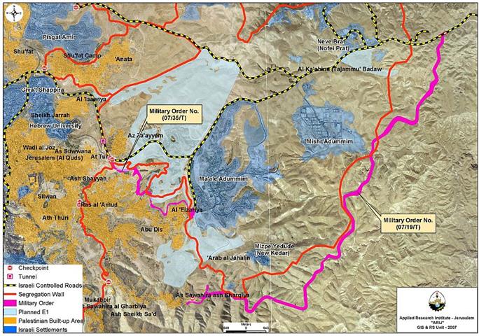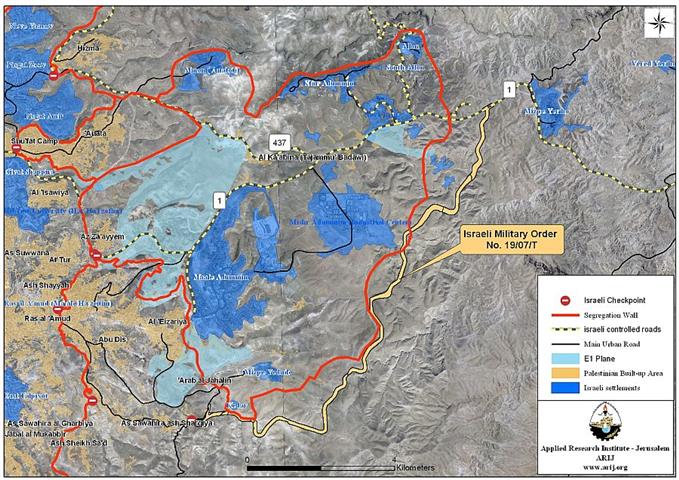
On October 4, 2007, the Israeli army revealed yet another part of the plan to isolate East Jerusalem from the West Bank. It happened with the issuance of a new military order under number no. (07/19/T), which states the confiscation of 1129 dunums of Palestinian lands in Abu Dis, Arab Al Sawahreh, An Nabi Musa and Al Khan Al Ahmar east of occupied Jerusalem. The order that was issued under the pretext of 'military purposes' showed a plan to construct a road to link the Palestinian governorates at the southern part of the West Bank with Jericho city east of the West Bank. ), which states the confiscation of 1129 dunums of Palestinian lands in Abu Dis, Arab Al Sawahreh, An Nabi Musa and Al Khan Al Ahmar east of occupied Jerusalem. The order that was issued under the pretext of 'military purposes' showed a plan to construct a road to link the Palestinian governorates at the southern part of the West Bank with Jericho city east of the West Bank.
According to the map attached to the military order, the planned road will extend from the Israeli checkpoint known as 'Al Container' located at the southeastern part of Abu Dis city east of Jerusalem Governorate, and then continue toward the east parallel to the south and eastern boundary of Ma'ale Adumim settlement bloc. After which, the road continues north to connect with bypass Road No. 1, which leads to Jericho city. It is worth mentioning that the road is routed in parallel to the Segregation wall's route, which will surround Ma’ale Adumim settlement bloc to annex it to Jerusalem.
An analysis conducted by the Geo-informatics Department at the Applied Research Institute-Jerusalem (ARIJ) showed that the targeted land for confiscated to build the road occupies an area of 1722, which is much more than what is stated in the Israeli Army’s military order by 593 Dunums. Table 1 shows the distribution of the land targeted for confiscation in the military order.
|
Table 1: Distribution of lands according to the Military Order |
|||
|
Palestinian Community |
Block |
Area |
Area Confiscated (Dunum) |
|
Abu Dis |
8 |
Al Zar'a, 'Arqoob El Jamal |
678.5 |
|
|
3 |
Satah Al Jazal, Al Majri, Al Qalla |
|
|
Arab As Sawahra |
6 |
Jouret Al Shardeh |
|
|
|
5 |
Marj Al Sultan, Sha'b Musa, Al Jinjis, Al Ratqa, Sha'b Arnaq, Jal Badawi, Jabal Al Dahda, Wadi Al Hakbar, Thahret Al Matraha |
350.3 |
|
An Nabi Mus (Jericho) |
6 |
Tal'et Ad Dub, Wadi Qteif |
148.5 |
|
Al Khan Al Ahmar |
1 |
Tabaq Qteif, Mukassar Al Huson, 'Aqbet Al Sukkar, Khallet Maser, Deir Al Mudawwara |
544.6 |
|
Total |
|
|
1721.9 |
Source: ARIJ GIS – September 2007
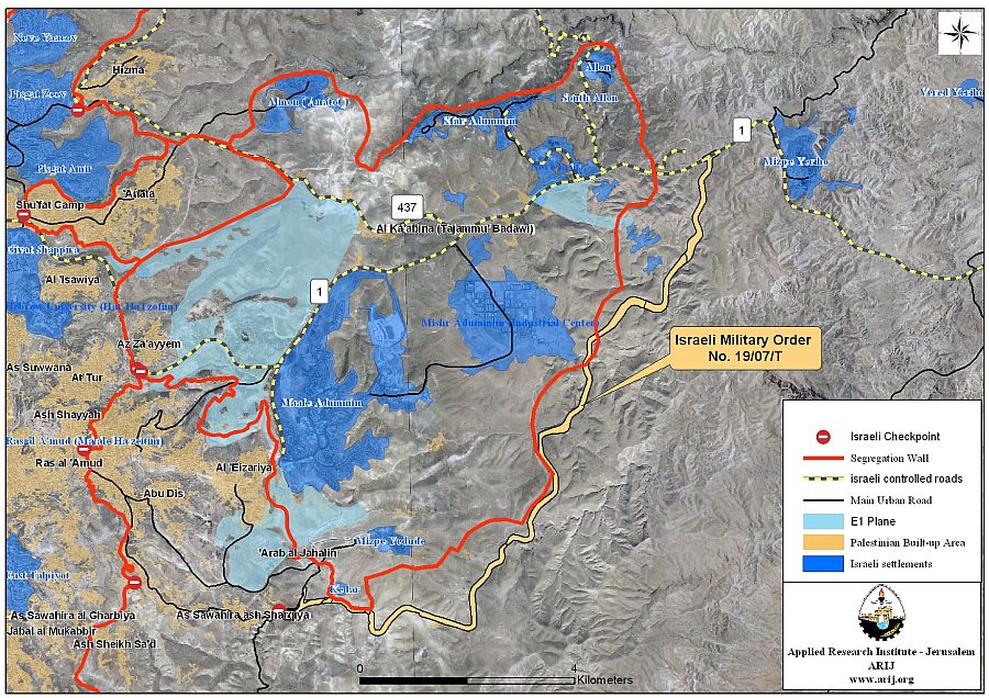
It is clear that the Israeli military order aims at preventing Palestinians from using the Israeli controlled Bypass Road No. 1, which passes by Ma'ale Adumim settlement bloc from its western side. This was the first step that the Israeli Army takes after announcing about the construction of the Segregation Wall around Ma’ale Adumim. This rerouting of roads used by Palestinians comes at a time when the Israeli government is showing determination to commence construction of the Jewish neighborhood known as 'E1' which was announced about in 1995 and was only approved in 2004; however, construction has been on hold due to constant international criticism about it.
The 'E1' neighborhood plan includes 3500 housing units in addition to public buildings. It will link Ma'ale Adumim settlement bloc with settlements in East and inside Jerusalem city at the expense of lands confiscated from several Palestinian villages east of the city such as Abu Dis, Al Ezariyeh, At Tur, Al 'Esawiyeh and Anata, who will be deprived from the lands designated for future expansion of their built-up areas.
Ma'ale Adumim settlements bloc is the largest of a total 6 Israeli settlements bloc in the West Bank that Israel intends to keep control of and annex to Israel under any peace negotiations with the Palestinians. Moreover, Ma'ale Adumim settlements bloc is one of three settlements blocs (Ma'ale Adumim settlement Bloc, Giv'at Ze'ev settlement Bloc, and Gush Etzion settlement bloc) to be included within the 'Greater Jerusalem' plan, creating geographical continuity between these settlements blocs and with settlements inside Jerusalem and Israel. On the other hand, the 'Greater Jerusalem' plan will exclude 13 Palestinian communities east of the city and deprive them their rights as residents their.
Back to the Israeli military order no. (07/19/T), it stated that the Palestinian residents of the four communities whose lands are targeted by the military order has 21 days to file their objections to the Israeli High Court against the Military order starting from the date of the field visit which will be carried out by the District Coordination Office in Jerusalem or by the Office of the juridical advisor in the region to specify the route of the road according to the Israeli Military order. This order is valid from the date it was signed and until 31/12/2011.), it stated that the Palestinian residents of the four communities whose lands are targeted by the military order has 21 days to file their objections to the Israeli High Court against the Military order starting from the date of the field visit which will be carried out by the District Coordination Office in Jerusalem or by the Office of the juridical advisor in the region to specify the route of the road according to the Israeli Military order. This order is valid from the date it was signed and until 31/12/2011.
The Israeli Minister of Public Security Avi Dieter, told Israeli sources (as published by Ha'aretz newspaper on the first of October 2007) that the head of Israeli police in the Jerusalem area (situated in Ras al-Amud neighborhood) will relocate its headquarter from Jerusalem to the “E1” planned neighborhood by the end of this year despite the United States' opposition to this step which clearly shows Israel's intention to move forward with implementing the E1 neighborhood despite international criticism.
Since 1993, right at the time when the peace process started, Israel has made several changes in the network of roads in the West Bank and the term bypass roads came to be, to classify roads designated for the Israeli settlers’ and Army’s use. Furthermore, the Israeli Army started to restrict Palestinians’ access to Jerusalem, and later on prevented them from entering Jerusalem. Palestinians were designated a different road system to use, to conform to the new coerced reality of the Segregation Wall in the occupied Palestinian territory. Israel has also made changes to the road network in the northern & southern West Bank areas during the past years and prepared a network of new roads for Palestinians to use ever since it announced about the construction of the segregation wall based on the facts on the ground including the segregation wall, the Israeli settlements, the closed military areas and so on.
Whatever work Israel carryout in the occupied territory, is done using military order and security purposes” as a pretext to do so, but contrary to what the international law states that any work carried out by the occupation forces must be on a temporary bases, but the facts on the ground shows otherwise.
Prepared by
The Applied Reserach Institute – Jerusalem