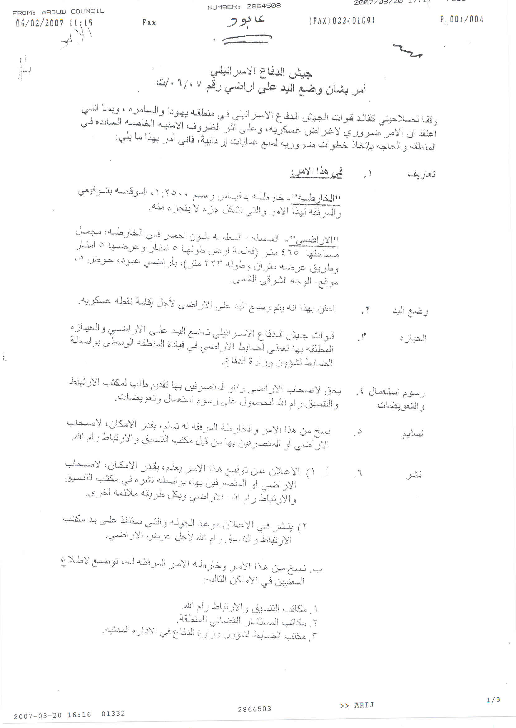
On February 6, 2007, the Israeli army handed out 'Aboud village council a new military order stating the confiscation of 465 square meters (0.465 km²) of 'Aboud village lands to construct a military observation point (watch tower) at the main entrance of the village. The affected residents were given a period of three days from the issuance date of the military order to put forward their objections. See translation of Military order.
|
Israel Defense Forces Order to Seize lands n0 07/06/T
According to my authorities as a Military Chief Commander in the Region of Judea and Samaria, and as I believe that it is imperative for military reasons due to the special security situation in the region, I order the following:
1- In This Order:
The 'Map' – signed in scale 1:2500 and attached to the order is an essential part of this order.
The 'Lands' – An area of land which is 465 meters marked in red in the map ( a piece of land of 5 meters long and 5 meters wide and a road of 2 meters wide and 223 meters long) and is located in lands of:
'Aboud · parcel 5, The eastern Shami Face 2- I announce by that the above mentioned lands are seized for installing a military observation point.
3- The IDF seize the lands and an absolute control of the land is given to the Military Chief Commander of the Central Region through the Ministry of Defense Chief Officer in the Civil Administration Office.
4- Land Owners have the right to go to the District Coordination Office in Ramallah Area to get usage expenses and compensation.
5- Copies of this military order and the attached map are handed out to Land owners or to the District Co-ordination Office in Ramallah Area.
6A-1 This military order is to be notified to Land Owners or those who act on behalf of them by posting it at the District Coordination Office in Ramallah Area and dispersing it on the lands by any possible mean.
6A-2: In this order, an announcement of the date of the field visit that will be carried out by the District Coordination Office in Ramallah is published.
6B- Copies of the military order and the attached map are available for interested parties at the following places: 1. DCO of Ramallah Area. 2. Offices of the juridical advisor in Judea and Samaria. 3. Office of Chief Commander in the ministry of defense at the Civil Administration. 4. Chief Office of the Absentee and Public Properties in the Civil Administration. 6C- Copy of the military order and the attached map is set at Ramallah area District Coordination Office Board for 10 days from the issuance date of the military order, as mentioned in Part (6A).
7- Land owners or those who act on behalf of ownership have the right to object the military order through the District Coordination Office in Ramallah or at the Office of the juridical advisor in the region. Works in installing the Military Observation point will be delayed for 3 days, starting from the date of the site visit.
8- This order is valid for 60 days from the date it was signed.
9- This order is called: 'Order to seize lands n0 07/06/T (Judea & Samaria) 5765-2005.
Ya'er Naveh Alof |
Copy of Military Order n0 07/06/T (Judea & Samaria)
The Israeli military order was issued on January 31, 2007, but was not handed out to Aboud council until 6 days later, hence denying the council the right to submit the objection as the three days opening allowed for the council to fight the military order had already passed by, which is to say that the order became a de facto reality.
According to 'Aboud village council, the construction of the military observation point (watch tower) at the village's main entrance will only add up to the daily dosage of suffering of the residents particularly that the targeted entrance where the Israeli Army plans to rig the watch tower is the only entrance leading to the village after as the Israeli Army closed all other entrances leading to the village during the past years since the eruption of the second Intifada in September 2000.
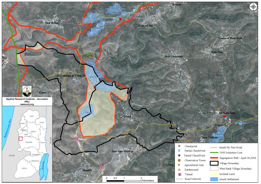
'Aboud Village : (location & population)
'Aboud village is located about 6.5 km of the 1949 Armistice Line (Green Line) and about 18 Km northwest of Ramallah city. The village spread on a total land area of 14928 dunums (14.928 km²); out of which 389 dunums comprise the built-up area. The village is a home to 2458 inhabitants according to the Palestinian Central Bureau of Statistics – 2006; most of whom work in agriculture.
The Israeli Segregation Wall in 'Aboud village
According to the April 30, 2006 revised Segregation Wall map, the wall will extend a length of 6.8 Km on lands of 'Aboud village, eating up 32 percent, some 4825 dunums of the village's land area (14928 dunums), the open spaces and the agricultural lands at the northwestern parts of the village, which will consequently become out of Aboud’s residents’ reach. See table 1 below.
Table 1: Land Use Land Cover of Aboud Village lands and lands isolated by the Israeli Segregation Wall.
|
Land use Land cover of 'Aboud Village lands (LULC) |
Total Land Area |
Land isolated by the Wall |
% from total village boundary |
|
Agricultural Lands |
6884 |
1221 |
8 |
|
Mine, dump and construction sites |
291 |
0 |
0 |
|
Open Spaces and Forests |
6673 |
2998 |
20 |
|
Palestinian Built-up area |
474 |
0 |
0 |
|
Israeli Settlements |
606 |
606 |
4 |
|
Total Area |
14928 |
4825 |
32 |
Source: ARIJ GIS Database 2006
Additional and significant annexation by the Segregation Wall aside from the Palestinian land; from an Israeli perspective are two Israeli settlements built on the lands of 'Aboud village, Ofarim (Est. in 1988) and Beit Arye (Est. in 1981) to Israel's proper. See Table 2
Table 2: Israeli settlements established on lands of 'Aboud Village
|
Settlement Name |
Establishment Date |
Area in dunums – 2005 |
Population – 2006 |
|
Ofarim |
1988 |
203 |
800 |
|
Beit Arye |
1981 |
401 |
3400 |
|
Total |
|
604 |
4200 |
Source: ARIJ GIS Database 2006
One Israeli bypass road (bypass road number 465) penetrates lands of 'Aboud village at its southern part and run a length of 6.082 km inside the village boundary. This bypass road is classified as 'Restricted use road', a road that can only be reached via an intersection manned by the Israeli soldiers at a checkpoint, due to the fact that other accesses from Palestinian villages adjoining this road are blocked by the Israeli Army. Palestinian residents are not required to posses a permit to use these checkpoints. However, the Israeli Soldiers require anyway checking people and vehicles before they are allowed to pass through the checkpoints.
The Israeli bypass 465 intersects with another Israeli bypass road holding number 446 (which is a completely prohibited road)at the southwestern part of 'Aboud village which run a total length of 1.183 km across Aboud village’s lands. See Map 1
To Conclude
The Israeli Army’s plan to construct a Military observation point (watchtower) will contribute only to increase the pestering of Aboud village residents and further tighten their movement in and out of the village to overall affecting all aspects of life in the village. It's construction is a clear violation to Article 12 of the International Covenant on Civil and Political Rights (ICCPR) which states that ''Everyone lawfully within the territory of a State shall, within that territory, have the right to liberty of movement and freedom to choose his residence.' Furthermore, it violates many basic human rights as codified in the Fourth Geneva Convention of 1949, of which, the right to education (Article 50), healthcare (Article 56), work and others, which are all compromised by setting up Israeli checkpoints and military points.
References:
1- 'Aboud, the city of flowers, threatened by the Israeli Segregation Wall , June 2005.
2- New Military Orders in 'Aboud Village – Ramallah District, October 2005.
:::::::::::::::___
[1] Forbidden Roads: The Discriminatory West Bank Road Regime. B’Tselem ( The Israeli Information Center for Human Rights in the Occupied Territories) – October 2004.
[2] Roads on which Israel completely forbids Palestinian vehicles. Forbidden Roads: The Discriminatory West Bank Road Regime. B’Tselem ( The Israeli Information Center for Human Rights in the Occupied Territories) – October 2004
Prepared by
The Applied Research Institute – Jerusalem
ARIJ