Israeli Occupation forces handed out residents of Beit Iksa, Nabi Samuel and Beit Surik a new military order stating the confiscation of 565 dunums of their lands for the construction of a section of the Segregation Wall that runs on their villages’ lands. The new military order holds number 89/06/T and will confiscate lands from Block 2 in An Nabi Samuel, Block 3 in Beit Surik village and Blocks,2,3,4,5,6,,7,8,9,11,13 of Beit Iksa. See copy and a translation of the military order.

|
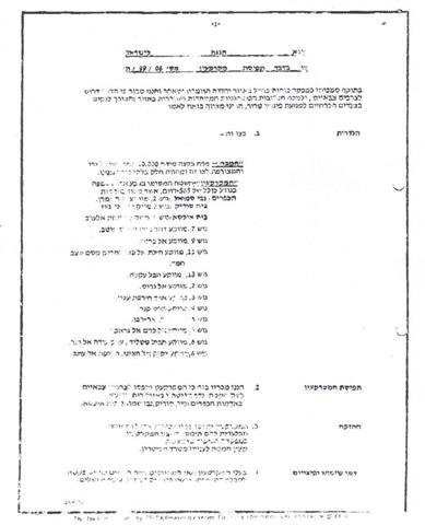
Israel Defense Forces Order to Seize lands n0 84/06/T
According to my authorities as a Military Chief Commander in the Region of Judea and Samaria, and as I believe that it is imperative for military reasons due to the special security situation in the region, I order the following:
1- In This Order:
The 'Map' – signed in scale 1: 10000 and attached to the order is an essential part of this order.
The 'Lands' – An area of land which is 565 dunums marked in red in the map and is located in lands of:
An Nabi Samuel
Beit Surik
Beit Iksa
2- I announce by that the above mentioned lands are seized for imperative military purposes, to construct the Wall on lands of Beit Surik, Beit Iksa and An Nabi Samuel.
3- The IDF seize the lands and an absolute control of the land is given to the Military Chief Commander of the Central Region through the Ministry of Defense Chief Officer in the Civil Administration Office.
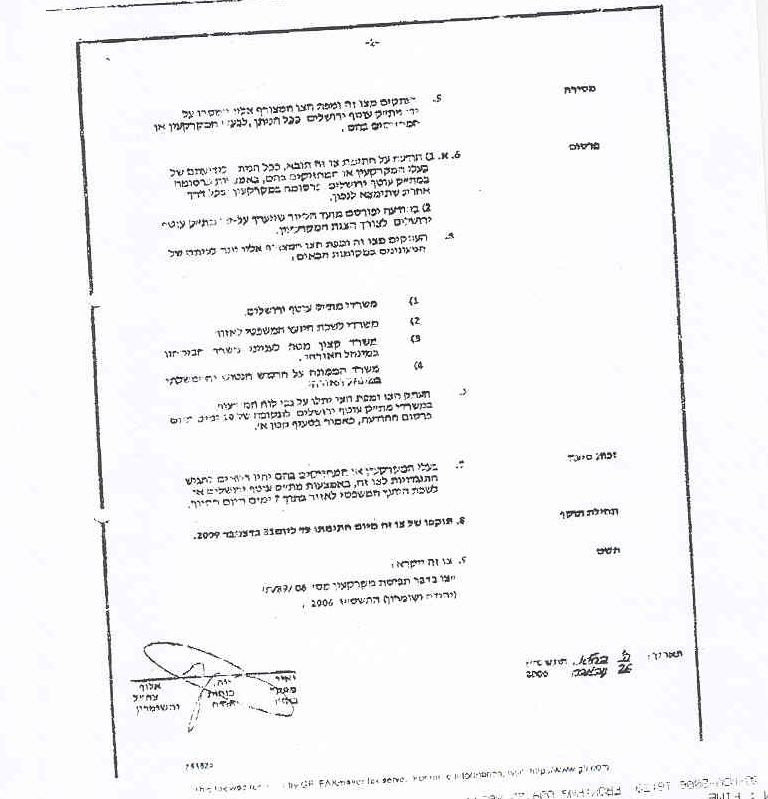
4- Land Owners have the right to go to the District Coordination Office in Jerusalem Area to get usage expenses and compensation.
5- Copies of this military order and the attached map are handed out to Land owners or to the District Co-ordination Office in Jerusalem Area.
5A-1 This military order is to be notified to Land Owners or those who act on behalf of them by posting it at the District Coordination Office in Jerusalem Area and dispersing it on the lands by any possible mean.
5B- Copies of the military order and the attached map are available for interested parties at the following places:
5C- Copy of the military order and the attached map is set at Jerusalem area District Coordination Office Board for 10 days from the issuance date of the military order, as mentioned in Part (5A).
6- Land owners or those who act on behalf of ownership have the right to object the military order in 7 days from the date of the field visit as mentioned in Part (5A) above through the District Coordination Office in Jerusalem area or at the Office of the juridical advisor in the region.
7- Land Owners have the right to go to the District Coordination Office in Jerusalem Area to get usage expenses and compensation.
8- This order is valid from the date it was signed and until 31/12/2009.
9- This order is called: 'Order to seize lands n0 84/06/T (Judea & Samaria) 5765-2005.
Ya'er Naveh
|
According to the military order, the village of Beit Iksa is to suffer the bulk of the confiscation order with 9 parcel Blocks of the village lie within the Segregation Wall path; in addition to above mentioned blocks from the other two villages.
The Segregation Wall in Beit Iksa Village
On April 30, 2006, the Israeli ministry of defense published on its web site an updated map of the Segregation Wall route in the West Bank; the map illustrated several changes on several parts of the Wall at various locations, the most significant of which in Ariel Settlements Bloc in Salfit, Al Jab'a village south of Bethlehem, Al Walajeh Village northwest of Bethlehem, and Beit Iksa village, northwest of Jerusalem city;
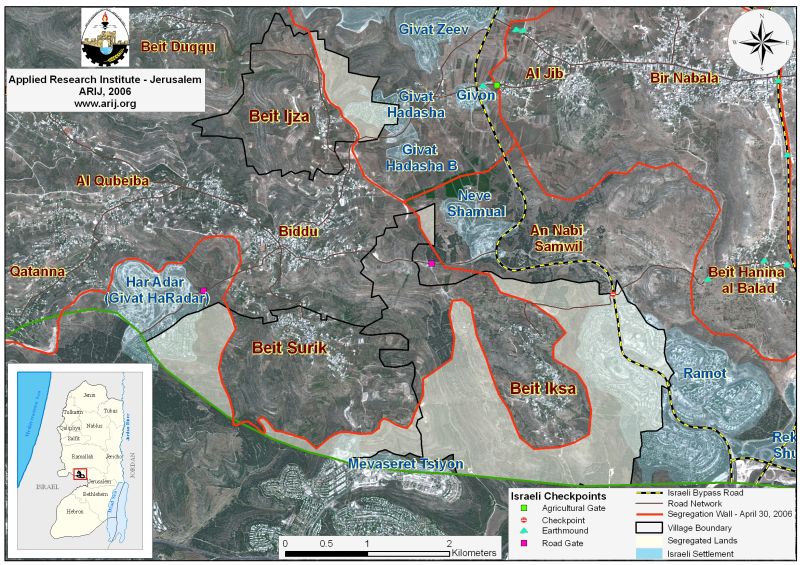
According to the updated Wall map of April 2006, the Segregation Wall in Beit Iksa was rerouted to take the village of Beit Iksa outside of the Wall enclave as was planned according to previously declared route in February 2005 where the village was totally separated from the neighboring Palestinian villages of Beit Surik, Biddu and the remaining Palestinian villages located west of Jerusalem City; See Map of February 20, 2005 Wall Path.

Today, with the new alterations, the new route of the Segregation Wall stands to cost the village of Beit Iksa about 60% (4556 dunums) of its total land area (7734 dunums), most of which are agricultural lands and open space area reserved for the village to expand its built-up area in the future. See Map of the wall in Beit Iksa Village.
The Segregation Wall in Beit Surik Village
According to the Wall map of April 2006, the village of Beit Surik, located northwest Jerusalem city stand to lose 1296 Dunums (31%) of its total land area (4244 dunums) for the construction of the Israeli Segregation Wall, which will surround the village from three sides, east, west and south and will snatch most of its agricultural lands and other natural resources; but more relatively, the Segregation Wall route will annex the settlements of Har Adar to Israel's proper. For more information, click here.
An Nabi Samuel and the Israeli Segregation Wall
The village of An Nabi Samuel is located to the northwest of Jerusalem city. It is bordered by the village of Beit Iksa and Ramot settlement from the south, Beit Hanina and Beit Hanina Al Balad villages from the east, the Israeli settlement Neve Samuel from the west, Al Jib, Al Judera and Beir Nabala villages from the north. The village occupies a total land area of 2142 dunums, out of which, 65 are classified Palestinian Built-up area.
The village of An Nabi Samuel lost a considerable portion of its lands for the construction of the Israeli Settlement Neve Samuel in 1996. Today the settlement occupies a total land area of 384 dunums, all inside the village boundary of An Nabi Samuel.
The Israeli Bypass Road number 436 dissects the western and southern terrains of the village. This bypass road connects the settlements of Ramot Allon, Reckhes Shu'fat and the rest of the Israeli settlements located to the south of An Nabi Samuel with those settlements located at its northern and northeastern sides; such as Neve Samuel, Giv'at Hadasha, Giv'at Hadasha B, Giv'on and with Giv'at Ze'ev settlements Bloc. See annex 1
The Israeli Segregation Wall on lands of An Nabi Samuel village
Today, residents of the An Nabi Samuel village (219 according to PCBS Population projection 2006) are facing the threat of the Israeli Segregation Wall, which stand to isolate most of the village's fertile lands including parts of the village’s built-up area, which will become isolated from the rest of the village and from the surrounding Palestinian villages as it will fall behind the designated route of the Segregation Wall that is set to encompass the settlement of Neve Samuel and Ramot towards Israel. See classification of Land Use Land Cover of An Nabi Samuel Village.
|
Table 1: Classification of Land Use Land Cover of An Nabi Sameul Vllage |
|||
|
Land Use Land Cover type |
Land Use Land Cover of An Nabi Samuel Village lands |
Land Use Land Cover of An Nabi Samuel Segregated Lands (dunums) |
Percent of the Total village area |
|
Arable land & Heterogeneous agricultural areas &Permanent crops |
645 |
602 |
28.1% |
|
Israeli Settlement |
300 |
300 |
14 % |
|
Palestinian Built-up Area |
65 |
65 |
3% |
|
Forests & Open spaces with little or no vegetation & Shrub and/or herbaceous vegetation associations |
1132 |
976 |
45.6 % |
|
Total Area |
2142 |
1943 |
90.7 % |
Source: ARIJ GIS DATABASE 2006
Table 1 above shows that An Nabi Samuel village will lose more than 90% of its lands once the Segregation Wall is completed. More than that, the village will be set in an enclave, totally segregated from the nearby Palestinian villages located to its west, east and northeastern sides such as the villages of Beit Hanina & Beit Hanina AL Balad, Al Jib Al Judera and Beir Nabala, villages of Beit Surik, Biddu and the rest western villages.
To conclude
Israel continues with the construction of the Segregation Wall with no regard to Palestinians' civil and humanitarian rights, which are totally and explicitly violated. The Palestinians are losing more than their lands and natural resources as Israel continues to oppress their freedom and their rights to movement, freedom of religion and to proper education and health services, right to work and to live adequately in houses and areas of their choice without restrictions, all of which guaranteed to them under International laws and Human rights conventions.
Annex 1: Bypass Road Number 436 originates from Giv'at Ze'ev settlement junction west of Jerusalem city and connects with Giv'on and Ramot Alon settlements, which lie on the same road. The bypass road then extends southwest to penetrate Al Walajeh village lands (west of Bethlehem) from its western side and moves eastwards to the Settlement of Har Gilo, southeast Al Walajeh village, where it finally connect with bypass Road number 60. Palestinians aren't allowed to travel on this road unless they are in possession of special permits issued from the Israeli civil administration.
Prepared by
The Applied Research Institute – Jerusalem
ARIJ