Jerusalem is the heart of the Palestinian state and is the focal point for the three monotheistic religions. Since 57 years Jerusalem has been suffering from the Israeli occupation which aimed at Israelizing the city; erasing its Arabic culture and history and evacuating the city from its Arab inhabitants. The paper at hand touches briefly on the historic conditions that played role in the formation of the current Jerusalem landscape, then will discuss the unilateral Israeli actions that preceded in the eastern part of the city after the 1967 war and the current Israeli plans in the city.
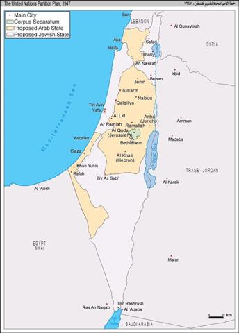
On November 1947, the United Nations General assembly Resolution No. 181, endorsed the partition of Mandate Palestine into two states, an Arab (Palestinian) state and a Jewish one, see map 1.

The Jews who owned only 6% of the land were allocated 55.5% of the land, while the Arabs who owned 94 % of the land were allocated only 44.5% of the land. Jerusalem under this partition plan was to be a Corpus Seperatum; that is a separate body run by an international administration, see Map 2 and Map 3.

Map 2: Corpus Seperatum
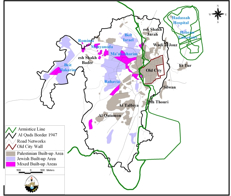
Map 3: Divided Jerusalem post 1948
The boundaries of this Corpus Separatum reached till beyond Bethlehem in the south and till Shuâ??ufat in the north and had an area of 186 km2. The Arabs at that time rejected the plan as it ignored the rights of the majority of the Arab Palestinian inhabitants. However, the 1948 war broke out and Israel took control of 78% of mandate Palestine, destroyed around 419 Palestinian villages and around 900,000 Palestinians became refugees. Jerusalem was divided into two separate entities: An Israeli West Jerusalem and an Arab East Jerusalem, see map 3.
On the 6th of June 1967, Israel launched a war that ended in the Israeli occupation of the rest of mandate Palestine, the Syrian Golan Heights and the Egyptian Sinai Peninsula. Soon after the occupation, the Israeli government expanded east Jerusalem municipal boundaries and increased the municipal area in east Jerusalem from 6.5 km2 to 71 km2 to include areas from 28 surrounding Palestinian villages. On the 11th of June 1967, the Israeli government annexed Jerusalem to the Israeli state. When the Israeli government redrew the municipal boundaries it included as much empty land as possible and excluded the highly populated Palestinian neighborhoods, see map 4. As a result the Palestinians in Jerusalem made up 25.8% of the population. . As a result the Palestinians in Jerusalem made up 25.8% of the population.
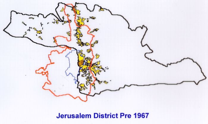
Map 4: Jerusalem post 1967
1- Impediments to Palestinian development in Jerusalem
Since 38 years, Israel had not hesitated from implementing its colonization project in the West Bank, especially in and around Jerusalem. Additionally the Israeli government imposed restrictions on the Palestinian development in Jerusalem from all aspects: the economic development, the physical and urban development the social development and the human development. Following are the procedures the Israeli government pursued to reinforce the impediments to the physical and urban development:
-
Land confiscation
-
Impose restrictions on land use
-
Constructing Israeli settlements and bypass roads
-
Segregate Jerusalem from the rest of the occupied Palestinian territory
1.1: Land confiscation
More than 32% of the lands inside the municipal boundary in east Jerusalem were confiscated. Jewish settlements were constructed on these lands.
1.2: Restrictions on land use
The Israeli government has imposed planning and zoning restrictions in East Jerusalem and enforced impediments on land use. Israel formulated policies that restricted land development and construction. These policies had the aim of imposing the Jewish supremacy in the city and undermining the Palestinian presence in it. The processes of obtaining building permits became long, tedious, expensive and disadvantages Palestinian residents of East Jerusalem. Buildings constructed without permits are usually demolished by Israeli authorities.
Following are some of the policies that were adopted by the government in East Jerusalem:
-
Confiscating the Palestinian land; nearly one third of the lands in east Jerusalem were confiscated to construct Jewish settlements.
-
Decreasing the area zoned as residential in the Palestinian neighborhoods in the city.
-
Imposing restrictions on the volume of construction and the floor area ratios.
-
The Palestinian areas lacked a town planning scheme or zoning plans, were only 38% of the remaining two thirds had an approved zoning plan.
-
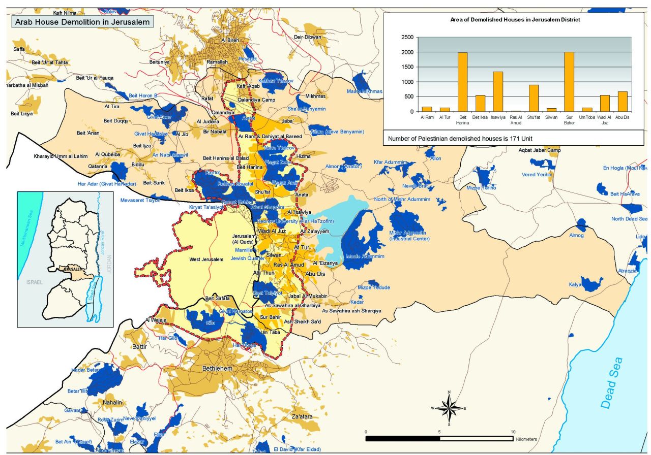
House demolition under the pretext of having no building permits or for security reasons. According to a study conducted by ARIJ, a total of 629 Palestinian houses have been demolished in Jerusalem during the last ten years.
-
13% of the areas were zoned as green areas where construction is prohibited. The green areas will be released to build Jewish settlements as was the case with Reches Shuâ??ufat and Abu Ghneim (Har Homa) settlements, see photo 1. settlements, .
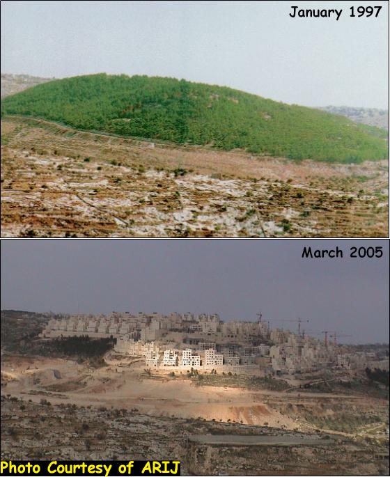
Abu Ghneim (Har Homa) settlements
-
Services and infrastructure lacked in the Palestinian neighborhoods resulting in under serviced and unhealthy living environment, the pressure on Jerusalem's land and natural resources has been devastating as well.
In the year 1945 the biggest five villages in the Jerusalem governorate were within the municipal boundary, while in the year 1995 the biggest villages were outside the municipal boundary; that is, the Israeli policies in Jerusalem have managed to reduce the urban growth within the city and forced it to the cityâ??s fringes. An example would be Al-Ram village that lies just on the outskirts of the municipal boundary whose population increased by 84 times during the fifty years.
1.3: Constructing Israeli settlements and bypass roads
Israel planned to strangulate the Holy city with Israeli settlements and highways, thus decrease the possibility of Palestinian development in the city and limit the prospects for East Jerusalem to be the capital of the future Palestinian state. Illegal Israeli settlements are being built in East Jerusalem in order to increase the Jewish Israeli population, maintain the demographic majority of Jewish Israelis within the municipal boundaries and strengthen the Israeli sovereignty over East Jerusalem, see map 5.

Map 5: Israeli settlements inside the municipal boundaries
The Israeli government had constructed settlement blocks that grow towards each other circumventing the Palestinian neighborhoods and isolating the Palestinian city from the rest of the West Bank. The first Israeli colonization activity in Jerusalem was soon after the 1967 war where the Israeli bulldozers entered the old city and demolished a whole neighborhood to expand the Jewish neighborhood from 7 dunoms to 130 dunoms. Furthermore, Israel was able throughout the past 38 years to get hold of 78Palestinian properties in the old city outside the Jewish quarter. Today there are 16 Israeli settlements inside the municipal boundary, these are:
|
Settlement name |
Date of establishment |
Area in 2005 (in dunom) |
|
Mamilla |
1997 |
52.7 |
|
Jewish Quarter |
1968 |
135.7 |
|
Atarot |
1970 |
1377.5 |
|
East Talpiyot |
1973 |
1829.4 |
|
Gilo |
1971 |
2749.8 |
|
Givat Hamatos |
1991 |
287.7 |
|
Givat Shappira |
1968 |
687.6 |
|
Hebrew University (Har HaTzofim) |
1968 |
957.5 |
|
Neve Yaacov |
1972 |
1240.9 |
|
Pisgat Amir |
1985 |
2515.9 |
|
Pisgat Zeev |
1985 |
1545.6 |
|
Ramat Eshkol |
1968 |
1118.3 |
|
Ramot |
1973 |
3343.4 |
|
Rekhes Shuafat |
1990 |
1624.9 |
|
Ras al A'mud (Ma'ale Ha zeitim) |
1998 |
10.8 |
|
Har Homa |
1997 |
2205 |
There are 32 settlements within the Jerusalem governorate boundaries, see map 6, these are:
|
Settlement name |
Date of establishment |
Area in 2005 (in dunom) |
|
Sha'ar Benyamin |
1999 |
574.4 |
|
Mamilla |
1997 |
52.7 |
|
Jewish Quarter |
1968 |
135.7 |
|
Kalya |
1968 |
867.7 |
|
Settler Houses in Old City |
|
19.9 |
|
Allon |
1990 |
294.7 |
|
Almon ( Anatot ) |
1983 |
807.1 |
|
Atarot |
1970 |
1377.5 |
|
East Talpiyot |
1973 |
1829.4 |
|
Givat Hadasha |
1980 |
313.3 |
|
Givat Hadasha B |
1991 |
63.7 |
|
Givat Shappira |
1968 |
687.6 |
|
Givat Zeev |
1982 |
1545.6 |
|
Har Adar (Givat HaRadar) |
1986 |
1192.8 |
|
Hebrew University (Har HaTzofim) |
1968 |
957.5 |
|
Kedar |
1984 |
53.6 |
|
Kfar Adummim |
1979 |
751.5 |
|
Maale Adummim |
1975 |
6510.4 |
|
Mizpe Yedude |
1980 |
310.2 |
|
Neve Shamual |
1996 |
391.9 |
|
Neve Yaacov |
1972 |
1240.9 |
|
Pisgat Amir |
1985 |
2515.9 |
|
Pisgat Zeev |
1985 |
1545.6 |
|
Ramat Eshkol |
1968 |
1118.3 |
|
Ramot |
1973 |
3343.4 |
|
Rekhes Shuafat |
1990 |
1624.9 |
|
Givon |
1978 |
118.4 |
|
Mishr Adummim (Industrial Center) |
1974 |
3377.7 |
|
Neve Brat |
1992 |
871.3 |
|
Kokhav Yaacov |
1984 |
2311.6 |
|
Adam ( Geva Benyamin) |
1983 |
1194.6 |
|
Ras al A'mud (Ma'ale Ha zeitim) |
1998 |
10.8 |
Map 6: Israeli settlements inside Jerusalem Govornorate
The range of these colonizing activities is far greater than the unilateral Israeli declared borders of Jerusalem. Behind these activities is the Israeli intention to widen the area of Jerusalem and to envelop further lands of the West Bank into its domain. An examination of the Israeli colonizing activities in and around Jerusalem reveals the gradual application of Israel's 'Greater Jerusalem' scheme, which includes the Givâ??at Zeâ??ev block, Maâ??ale Adumim block and the Gosh Etzyon block.
1.4: Settlement expansions
Between August 2002 and August 2004, Israel constructed around 32,632 new housing units in 58 settlements in the West Bank. The bulk of this Israeli construction occurred in settlements in the East Jerusalem and Bethlehem regions in the region known as the 'Greater Jerusalem,' which includes the Maale Adumim block, Gosh Etziyon Block, Givaat Zeev and Giv'at Binyamin blocks. Approximately 15,400 units (47%) were added to Jerusalem settlements and nearly 10,500 units (32%) were constructed in the Bethlehem settlements. The largest expansion projects occurred in the following five settlements (most of them are within 'Greater Jerusalem' region):
-
Ma'ale Adumim (Jerusalem): 5,712 new housing units
-
Betar Illit (Bethlehem): 4,832 new housing units
-
Har Homa (Bethlehem): 3,692 new housing units
-
Har Adar (Jerusalem): 2,832 new housing units
-
Giv'at Binyamin or Adam (Jerusalem): 1,536 new housing units
Current Israeli plans call for continued settlement expansion in the West Bank, particularly within the â??Greater Jerusalemâ?? area. A report released by the Israeli daily Yedoit Aharonot on February 25, 2005 revealed that the Israeli government has planned at least 6, 391 new housing units as part of Israel Lands Administration (ILA) settlement plans for 2005. A list of settlements and expansion plans printed in the article, however, places the planned expansion at 7,891 units. Furthermore the ILA plan for 2005 includes also the consolidation of 120 illegal outposts in the West Bank, 'for which planning and contractual arrangements' will be made. Table 3 details these proposed expansions:
| Planned SettlementExpansion in the West Bank (2005) | |||
| Name | New Housing UnitsPlanned | West BankDistrict | Planned Units byDistrict |
| Ma'aleAdumim | 3,600 | Jerusalem | 4,002 units |
| Geva Binyamin (Adom) | 200 | ||
| GivatZe'ev | 132 | ||
| GivatZe'ev | 70 | ||
| BetarIllit | 500 | Bethlehem | 559 units |
| HarGilo | 35 | ||
| AlonShvut | 24 | ||
| Modi'inIllit | 1,500 | Ramallah | 1,500 units |
| Zufin | 1,500 | Qalqilya | 1,500 units |
| EtzEphraim | 240 | Salfit | 330 units |
| Elkana |
90 |
||
| Total PlannedExpansion in the West Bank (2005) | 7,891 units | ||
58% of the planned constructions are in the 'Greater Jerusalem' region. The expansion of these settlements consolidates Israeli control over the area, see map 7.

Map 7: Greater Jerusalem
The E1 plan
The largest expansion project currently planned, however, is the E1 expansion project adjacent to the sprawling Ma'ale Adumim settlement in East Jerusalem. The E1 Plan calls for the largest single settlement construction project in recent history. Bulldozers begun to clear Palestinian land north of the large Israeli settlement of Ma'ale Adumim in December 2004 but it was only on February 28 that the Israeli government announced its intention of building at least 3,500 new housing units on the site. The E1 Plan intends to appropriate approximately 12,500 dunums (125 km2) of Palestinian lands belonging to the Palestinian villages of Al-Tur, â??Anata, Al Eizaryieh, Abu Dis, Al Essawyieh and Hizma, see map 8.
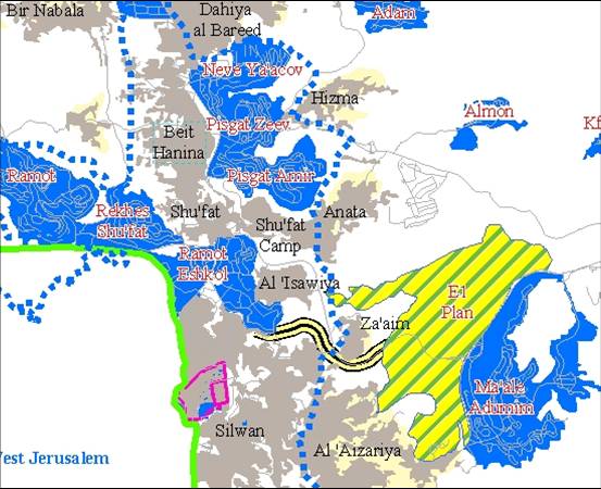
Map 8: E1 plan
Ma'ale Adumim is the largest Israeli settlement in the Occupied Palestinian Territory with a population of approximately 30,000 and more than 22,000 dunums (220 km2) of expropriated Palestinian lands (of which only about 3,000 dunums (3 km2) constitute the built up area. The E1 Plan will increase this area by more than 50% and will link Ma'ale Adumim to other settlements in East Jerusalem including Pisgat Ze'ev, Pisgat Omer, Neve Yaa'acov and French Hill.
The new expansion plays a crucial role in Israel's goal of isolating Jerusalem from the rest of the West Bank and encircling the Palestinian neighborhoods of East Jerusalem with Jewish settlements. The E1 expansion also drives a deep wedge through the center of the West Bank, cutting of the northern Districts from the south and allowing Israel to control Palestinian movement between the disconnected cantons. Paired with already existing settlements in the Jerusalem region, the E1 plan also makes a geographically contiguous and viable Palestinian State impossible.
The Segregation Wall around Jerusalem (the so called Jerusalem envelope)
The segregation wall around Jerusalem is planned to extend for 190 km, extending from the settlement of Har Adar, encompassing the Givaâ??at Zeâ??ev settlement block, slicing between Palestinian communities, extending eastwards and encompassing the Maâ??ale Adumim settlement block, and stretching toward the south and encompassing the Gosh Etzion settlement block. 40 kilometers of the Segregation Wall were completed by mid 2005, 40 km are under construction while 110 km are planned sections, of which 40 km are for the Maâ??ale Adumim settlement block envelope. The segregation wall will isolate 230km2 (4% of the total area of the west bank). The isolated area includes 30 km2 of Palestinian built-up area, 50 km2 of Israeli settlements built-up area while 65% of the isolated area in Jerusalem is an open area. The Jerusalem envelope will segregate 45% of the Jerusalem Governorate area and 13% of the Bethlehem Governorate area. There will be around 230,000 Palestinians in Jerusalem that will be cut from the rest of the West Bank and will be segregated by the Wall, see map 9.
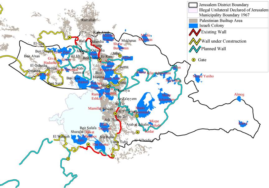
Map 9: Jerusalem Envelope

The wall aims in East Jerusalem, as in the rest of the West Bank, to appropriate as much Palestinian land as possible and sever the traditional connection between Jerusalem and the rest of the West Bank. The route of the Wall reinforces the settlement blocks and appropriates additional lands for the settlement expansions and other development projects.
Policies to drive the Palestinian outside of Jerusalem
Meanwhile, Palestinian Jerusalemites have witnessed a set of discriminatory measures gradually adopted and codified in the legal and bureaucratic policies of the Israeli government. Israel has used these measures to limit the natural growth of Jerusalem's Palestinian population and force them to move out of the city. Some of these policies include: restriction of residency rights and discriminatory tax systems.
In addition to the governmental policies, the various Jewish organizations, operating in Jerusalem, have played a critical role in increasing and strengthening the Jewish existence in the city. Over the years, these Jewish organizations have raised tens of millions of dollars from wealthy Jews to reinforce the Jewish presence in the heart of East Jerusalem, especially inside the old city and in the area known as the Holy Basin; among the projects:
1. The Project for the Restoration of Jerusalem which was founded in 1977 with the help of Canadian millionaire Mark Belzberg, and Prime Minister Netanyahu.
2. In 1989, the Ateret Kohanim Jewish Organization attained St. John's Hospice in the Christian Quarter which had belonged to the Greek Orthodox Church.
3. The Construction of a Jewish neighborhood in Ras al-Amud in Jerusalem administered by Yossi Kaufman, Head of Ateret Kohanim Yeshiva and the Jerusalem Municipality who approved the plan to build 132 apartments on the 15-dunam site in 1998).
4. ELAD foundation was established in 1986 with the aim of constructing what is called 'city of David' in the place that is home to the Silwan residents for hundreds of years. At least 10 houses in Wadi Hilweh were taken by force by Israeli settlers (were 25 families are currently living, additionally a Talmudic center and a visitor's center -that is responsible for conducting tours along the old cisterns and tunnels that lie beneath Silwan- were founded.
Additionally, residents of East Jerusalem are also subject to increased taxation. Israeli authorities collect an 'Arnona tax' on both residential and business spaces based on building, office and apartment size. The Arnona tax in Jerusalem is regressive and does not take into consideration differences in income level, family size or other factors. The tax falls most heavily on Jerusalem's Palestinian population, including residents of the Old City. Those who are unable to pay the taxes face punitive measures such as fines, imprisonment and/or seizure of property.
Conclusion
Measures leading to major demographic shifts have been staged by Israel in order to create an exclusive Jewish population in East Jerusalem. Strategies have been adopted to restrict the natural expansion of the city's Palestinian communities. The Israeli government has not stopped its unilateral practices in Jerusalem by which it creates de facto realities on the ground. These de facto realities are clearly affecting the outcome of the negotiations on the final status of Jerusalem, in Israelâ??s favor, an action that is in total violation to United Nationsâ?? resolutions, particularly 298, 465 and 242, as well as standing Palestinian-Israeli Oslo Agreements.
An examination of the current Israeli activities in and around East Jerusalem reveals a systematic plan which aims at Israelizing and strangulating the Palestinian city and separating it from the West Bank. The intensity and multi-location of these activities shows the Israeli persistence to change the physical and demographic structure of Jerusalem before proceeding with the stalled negotiations on Jerusalem.
-
[1] ELAD foundation website, http://www.cityofdavid.org.il/itiashvut-eng.htm
-
[i] Jerusalem: Heritage and Life. Welfare Association
-
[i] Yedoit Aharonot (Hebrew). February 25, 2005. See also ' APN Attacks Plan for 6,000+ New Settlement Houses, Authorization for 120 Illegal Outposts.' Americans for Peace Now. February 25, 2005 (http://www.peacenow.org/pr.asp?rid=&cid=337).).
-
ARIJ GIS Unit 2005.
Prepared by:
The Applied Research Institute – Jerusalem