Israeli occupying forces began to construct additional sections of the Segregation Wall in East Jerusalem last week. The new construction is closing existing gaps between Al Ram and the neighboring towns of Beir Nabala and Beit Hanina and stretching around the eastern side of Al Ram. When complete, the Wall will encircle Al Ram (with a population of 25,215 inhabitants) on four sides leaving only two exits. The first, at the Al Ram checkpoint south of the city, will be controlled by Israeli soldiers and only accessible to those holding special permits. The second, will lead away from Jerusalem towards Ramallah, and may also be controlled and monitored by Israeli soldiers. The Segregation Wall cutting close around Al Ram is rapidly turning the town into another Palestinian ghetto.
The Segregation Wall in East Jerusalem
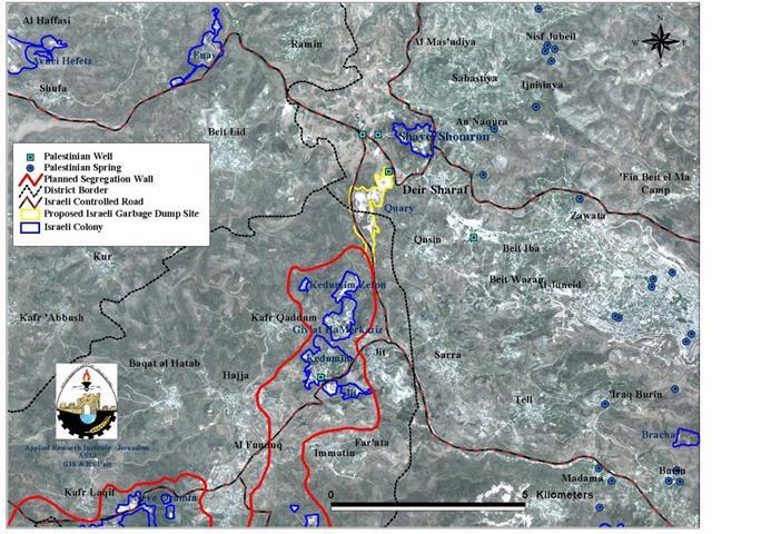
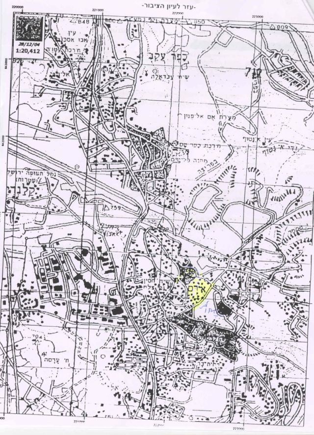
The Segregation Wall in East Jerusalem facilitates Israel's colonization plans for the city. This strategy aims to limit the Palestinian areas and appropriate additional lands for illegal Israeli settlement construction and other development projects. When complete, the Wall in East Jerusalem will stretch for more than 113 km, separating Israeli settlements in the area, grabbing open areas, and slicing between Palestinian towns. The goal in East Jerusalem, as in the rest of the West Bank, is to appropriate as much Palestinian land as possible and sever the traditional connection between occupied East Jerusalem and the rest of the West Bank (see Map One).).
Map One: Al Ram in a Regional Context
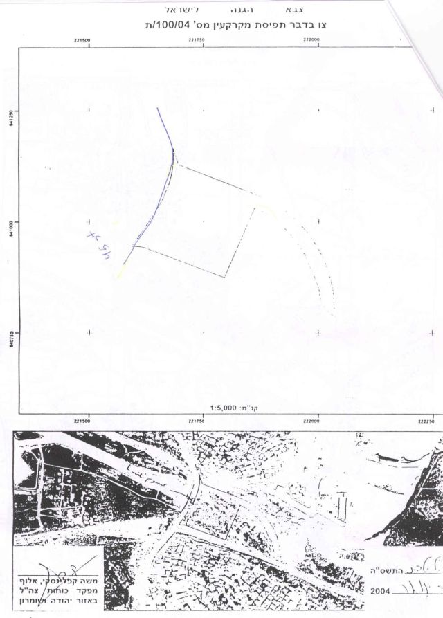
The Segregation Wall around Al Ram and Dahyet Al Barid
Al Ram is one of the most densely populated neighborhoods in Jerusalem. It is located in the northeastern part of the city. The built-up area of the town is approximately 3,289 dunums (3.3 km2). The Wall stretches for six km around Al Ram, encircling the built-up area, controlling the movement of its residents and appropriating large areas of Palestinian lands for the expansion of illegal Israeli settlements. When the Wall is finished, Al Ram will be cut off from the rest of East Jerusalem and isolated in a tiny ethnic Palestinian ghetto.
Israeli occupying forces began construction of the Segregation Wall around Al Ram in May 2004.
-
On May 17, Israeli bulldozers started razing land in the Dahyet Al Barid neighborhood and the 'Ayad neighborhood (home to a large portion of Palestine's Coptic Christian population) on the outskirts of Al Ram.
-
On May 25, Israeli occupying forces served residents of Al Ram, Hizma and Beit Hanina military orders (numbered 04/06/T) and land seizure documents detailing the path of the Segregation Wall in the area.
-
Three days later, on May 28, Israeli bulldozers started to clear land along the western edge of Al Ram and the main road leading between Jerusalem and Ramallah. From May 2004 through March 2005, Israeli occupying forces continued to erect the 6-8 meter cement panels composing the Segregation Wall around Al Ram.
-
On March 3, 2005, Israeli occupying forces served two additional military orders to the village. The military orders (numbered 5/34/T and 5/36/T) specified that an additional 6 dunums of Al Ram land would be confiscated for construction of the Wall. The orders also confiscated more than 15 dunums from the neighboring localities of Jaba' and Hizma (See Appendix for an example of Israeli military orders served to residents of Al Ram).
The current phase of construction to the south of Al Ram cuts close to Palestinian homes in Jabal al Sumood neighborhood near an Israeli military base and comes up directly against Palestinian homes in the39;Al Aqbat39; neighborhood adjacent to the illegal Israeli settlement of Neve Ya39;acov (see Photo One). The home of Qawasmeh family is only one meter away from the Wall39;s path and is in danger of imminent demolition (See Photo Two). The Wall also cuts around a stone quarry in this area; annexing the entire region to Neve Ya39;acov settlement and opening it to continued settlement expansion (see Photo Three and Charts One and Two).). The Wall also cuts around a stone quarry in this area; annexing the entire region to settlement and opening it to continued settlement expansion (see and Charts One and Two).). The home of Qawasmeh family is only one meter away from the Wall39;s path and is in danger of imminent demolition (See ). The Wall also cuts around a stone quarry in this area; annexing the entire region to settlement and opening it to continued settlement expansion (see and Charts One and Two).
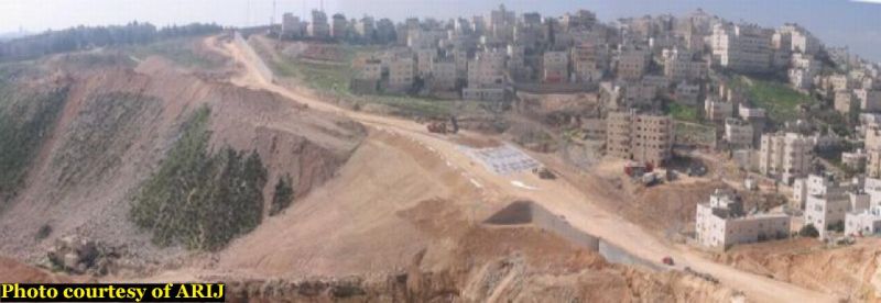
Photos One: Construction of the Wall East of Al Ram
The Segregation Wall cuts close to Al Ram on its Eastern edge, appropriating large areas to the illegal Israeli settlement of Neve Ya'acov, which sits on the opposite hill, left of the Wall.

Photo Two: Qawasmeh Home, threatened with Demolition: Qawasmeh Home, threatened with Demolition
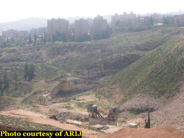
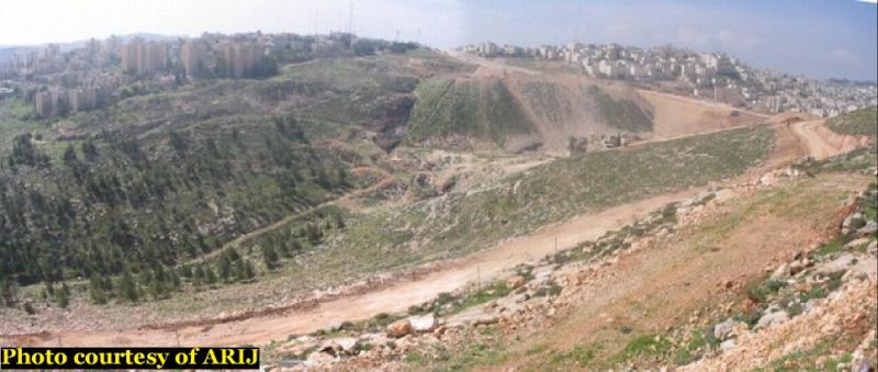
Photo Three: Appropriated Stone Quarry with Neve Ya'acov behind: Appropriated Stone Quarry with behind
East of Al Ram, the Wall slices into the Dahyet Al Barid neighborhood, appropriating open areas and rolling hills. Several Palestinian homes in the neighborhood have already been demolished to clear space for the Wall. North of Al Ram, the town is limited by an Israeli by-pass road that cuts deep into the hillside. The steep cliffs of the roadside make the gap impassible and the only bridge (leading to the village of Jaba') has been blocked by earth mounds placed by Israeli occupying forces (see Photos Four and Five).
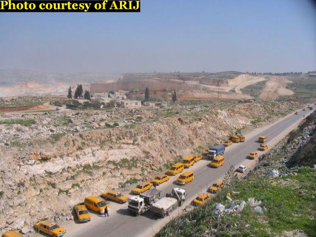
Photo Four: By-Pass Road along Al Ram's Northern Edge: By-Pass Road along Al Ram's Northern Edge
Photo Five: Roadblock Between Al Ram and Jaba': Roadblock Between Al Ram and Jaba'
In the northwest corner of Al Ram, Israeli bulldozers are busy constructing what is believed to be a new road leading to Ramallah. This will be the only exit most Al Ram residents will be allowed to use. It will most likely be monitored by an additional Israeli checkpoint. The current checkpoint of Qalandyia may be moved as the Wall is extended along the northern border of Al Ram beside what is now an Israeli military camp. Israel is also reportedly planning to build a new DCO (District Coordinating Office) on this site. Palestinians will have to apply to the DCO for any permits needed to access areas controlled by Israel, including Jerusalem.
The Western edge of Al Ram is marked by a long section of the Segregation Wall stretching north to south along the main road from Jerusalem to the Qalandyia checkpoint and Ramallah beyond. The Wall separates Al Ram from the Israeli industrial zone of 'Atarot, which is partially constructed on Al Ram lands and the Palestinian towns of Beir Nabala and Beit Hanina (see Photo Six and Map Two).
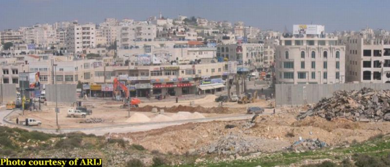
Photo Six: Israeli Construction Crews Close Gaps in the Wall Between Al Ram (behind) and Beir Nabala: Israeli Construction Crews Close Gaps in the Wall Between Al Ram (behind) and Beir Nabala

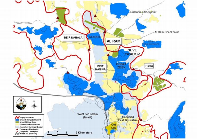
Map Two: The Segregation Wall in Al Ram: The Segregation Wall in Al Ram
Beit Hanina, Beir Nabala and Al Ram
Residents of the neighboring Palestinian towns of Beir Nabala and Beit Hanina have come to depend on Al Ram as a commercial center providing much needed services. Al Ram's commercial sector provides goods at more affordable prices than the high prices in Jerusalem's downtown stores. Students from Beir Nabala and Beit Hanina also attend schools in Al Ram which will now be isolated behind the Wall. The two towns, however, face very different circumstances.
Beit Hanina is part of the illegally annexed Jerusalem municipality. Residents of the town therefore are forced to pay high taxes leveled by the municipality (including social services fees and water, electricity, etc.) and the discriminatory arnona property tax. Beit Hanina, however, will have an open link to Jerusalem and residents will be able to access the downtown markets. Beir Nabala, on the other hand, will be severed from both Al Ram and Jerusalem. According to Israel's 'finalized' plan for the Wall, Beir Nabala will inhabit an additional ghetto with a single link to Ramallah via a road through the town of Rafat which will be monitored by Israeli occupying forces. Under normal circumstances a trip from Beir Nabala to Al Ram would take 2-3 minutes. When the Wall is complete, this trip will take 2-3 hours.
Many residents of both Beit Hanina and Beir Nabala have family living in Al Ram. The Wall will sever these family connections. When complete, it will be nearly impossible for many people to visit family in Al Ram. This aspect of segregation has been repeated wherever the Wall cuts through the urban fabric of Palestinian areas, especially in East Jerusalem.
The Wall in Al Ram and Restrictions on Freedom of Movement
The restraints on freedom of movement are reflected in the case of Al Ram's residents as well. Many of Al Ram's residents possess East Jerusalem ID, allowing them to live and work within the illegally expanded municipal boundaries of Jerusalem. When the Wall is complete, however, the city will be severed from Jerusalem and travel may be difficult. Many Palestinians with East Jerusalem ID, moreover, have kept properties inside the city but live in the cheaper suburbs, such as Al Ram.
Israel's recent threat to impose its Absentee Property Law in East Jerusalem targeted these individuals, who hold East Jerusalem ID but are unable to afford the costs of living in the city. If the Absentee property Law is applied to East Jerusalem, these residents will be relegated permanently to the West bank and will not be able to access Jerusalem.
Residents of Al Ram who hold West Bank ID are not allowed by Israel to travel to Jerusalem without a special permit (Tayfer). Holders of Tayfer permits must apply for a new permit at least once a year. It will become much more difficult for Al Ram's residents to obtain these permits and move freely to Jerusalem after the Wall is closed around their city. They risk being cut off from much needed social services (including schools and healthcare facilities) and family living on the other side of the Wall.
The Segregation Wall will also isolate a group of homes in Dahyet Al Barid which will be left outside the Wall and cut off from Al Ram. Israeli occupying forces have issued one-year temporary permits to residents of the area. The permits allow them to stay in their homes but do not allow them access to any other areas in Jerusalem. Presumably, there will be a gate in the Wall, monitored by Israeli occupying forces, allowing residents access to the area. If the gate ismanaged in the same manner as other Wall gates, it will only be open two or three times a day for a total of 2 or 3 hours and access will be arbitrarily granted by Israeli soldiers at the gate.
Settlement Expansion
East of Al Ram the Segregation Wall appropriates additional lands adjacent to Neve Ya'acov settlement. The settlement is partially built on Al Ram lands and the Wall will open up vast areas for the expansion of Neve Ya39;acov or the construction of a new settlement in the region (see Charts One and Two for information on the expansion of Neve Ya39;acov). Israeli peace group, Gush Shalom, reports that Israel plans to build additional settlement units in the area, although that reports cannot be verified at this time.
The lands appropriated east of Al Ram and the neighborhood of Dahyet al Barid are the only open spaces in Al Ram. The Wall will segregate these lands from the densely populated urban area, further affecting the population density inside the town. The Wall also appropriates a Palestinian stone quarry and stone cutting equipment.
|
Chart One: Expansion of Neve Ya'acov (selected years) |
||||
|
|
199o |
1996 |
2000 |
2003 |
|
|
|
|
|
|
|
dunums |
929 |
99 |
1,229 |
1,280 |
|
kilometers2 |
0.93 |
1.0 |
1.23 |
1.28 |
|
|
|
|
|
|
|
Increase (% of previous area) |
N/A |
7% |
19% |
4% |
|
Chart Two: Population Growth of Neve Ya39;acov (1996-2003) |
||||||||
|
|
1996 |
1997 |
1998 |
1999 |
2000 |
2001 |
2002 |
2003 |
|
Pop. |
16,150* |
17,408* |
17,850* |
18,304* |
18731* |
19,245* |
20,316 |
20,300 |
* Exact data is unavailable. These numbers are a projection taken from the combined population of Neve Ya'acov and the neighboring settlement of Pisgat Ze'ev.
The Segregation Wall in International Law
Israel39;s Segregation Wall violates numerous United Nations Security Council and General Assembly Resolutions. United Nations Security Council Resolution 242 (1967), drafted immediately after Israel occupied the West Bank and Gaza Strip, demands 'the withdrawal of all Israeli armed forces from the territories occupied' in the war.
The requirements of Resolution 242 are re-enforced and strengthened by UN Security Council Resolutions 452 (1979) and 465 (1980). Resolution 465 states categorically that: 'all measures taken by Israel to change the physical character, demographic composition, institutional structure of status of the Palestinian and other Arab territories occupied since 1967, including Jerusalem, or any part thereof, have no legal validity and that Israel's policy and practices of setting parts of its population and new Immigrants in those territories constitute a flagrant violation of the Fourth Geneva Convention Relative to the Protection of Civilian Persons in Time of War and also constitute a serious obstruction to achieving a comprehensive, just and lasting peace in the Middle East. 39;
Israel39;s Wall is also a flagrant violation of international humanitarian law, specifically the Hague Regulations of 1907 and the Fourth Geneva Convention of 1949:
-
The Hague Regulations expressly forbids an occupying power 39;to destroy or seize the enemy39;s property, unless such destruction or seizure be imperatively demanded by the necessities of war' (Article 23).
-
The Fourth Geneva Convention, the primary document of international law governing instances of military occupation, states in Article 49 that:39;The occupying power shall not deport or transfer parts of its own population into the territories it occupies39;
-
Article 53 of the Fourth Geneva Convention is also clear that:39;any destruction by the Occupying Power of real or personal property belonging individually or collectively to private persons, or to the State, or to other public authorities, or to social or cooperative organizations, is prohibited, except where such destruction is rendered absolutely necessary by military operations.39;
-
The appropriation and destruction of Palestinian land is an especially serious violation of the Fourth Geneva Convention, Article 147 of which clearly prohibits, 39;39;extensive destruction and appropriation of property, not justified by military necessity and carried out unlawfully and wantonly.39;39; Violations of Article 147 constitute grave breaches of the Convention and should be prosecuted as War Crimes.
In addition, the Segregation Wall also violate the prohibition against discrimination as defined by the Convention on the Elimination of All Forms of Racial Discrimination (1969). The first article of the Convention defines 39;racial discrimination39; as:39; Any distinction, exclusion, restriction or preference based on race, color, descent, or national or ethnic origin which has the purpose or effect of nullifying or impairing the recognition, enjoyment or exercise, on an equal footing, of human rights and fundamental freedoms in the political, economic, social, cultural or any other field of public life.39;
Many Israeli policies in the OPT discriminate against Palestinians. The Segregation Wall is a concrete example of the systematic nature of this discrimination. The Wall forcefully separates illegal Israeli settlements from Palestinian areas, consolidating the freedoms of Israeli settlers and violating the rights of Palestinian residents of the OPT.
The systematic nature of Israel39;s occupation policies (including the Segregation Wall) also submit it to a further section of international law. Israel39;s military occupation and the accompanying policies it enforces in the OPT comprise a crime of apartheid according to the International Convention on the Suppression and Punishment of the Crime of Apartheid (1973). The Convention defines apartheid as: 39;the imposition of various legislative measures on different racial groups while injuring the rights of one. Moreover, the crime of Apartheid comprises a39;crime against humanity39; and 39;a serious threat to international peace and security.
Conclusion
The Segregation Wall in Al Ram is highly illegal. The Wall's violation of UN Security Council Resolutions 242, 452 and 465 cannot be reconciled and its failure to comply with the Fourth Geneva Convention requires that it be completely dismantled. In fact, the International Court of Justice ruled on July 2004 that the Wall should be immediately destroyed. Israel, however, has continued to flout international law and the international consensus by continuing with the Segregation Wall project.
The Wall in Al Ram is being used to ghettoize the community and appropriate vast portions of land for settlement expansion. Israel has used the wall to take control of additional Palestinian lands and has already begun constructing new settlements in northern districts of the West Bank such as the Qalqilya District (see Jayyus case study). Evidence suggests that Israel has similar plans for the lands appropriated from Al Ram. ). Evidence suggests that Israel has similar plans for the lands appropriated from Al Ram.
The Wall will also severely affect the standards of living for residents of the area. Al Ram is a commercial center and neighboring localities such as Beit Hanina and Beir Nabala will be cut-off from the city. Residents of Al Ram will also be segregated from the educational, health and other social services they depend on in East Jerusalem. In the final analysis, the Segregation Wall will create additional difficulties for Palestinians, placing additional restrictions on freedom of movement, contributing to the impoverishment of the civilian population and facilitating the large-scale appropriation of Palestinian land by Israeli occupying forces. This situation can only inflame tensions in the region and stoke the flames of conflict between the occupied Palestinian population and Israeli occupying forces.

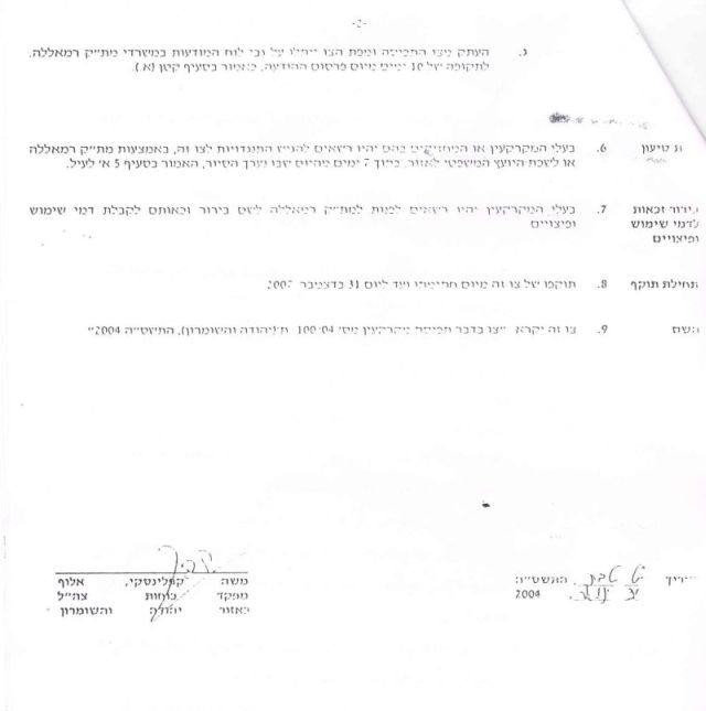
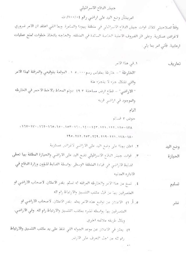
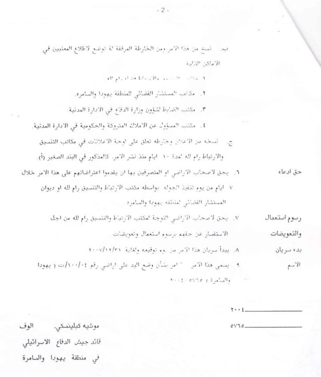
Appendix: Example of Israeli military orders in Al Ram
[1] The Palestinian Central Bureau of Statistics, 2004.
[2] Israel ratified the Convention in 1979.
[3] The International Convention on the Suppression and Punishment of the Crime of Apartheid (1973), Article II, Sections (c) and (d). See also the Convention on the Elimination of Racial Discrimination, Articles 2, 3 and 5.
[4] Ibid (Article 1).
Prepared by:
The Applied Research Institute – Jerusalem