Introduction
Bethlehem is historically an area of religious importance to the three monotheistic religions, especially to the Christian faith. It was known as Beit Ello in the fourteenth century B.C., which is the Canaanite God of Wheat, and as Ephrata in the Old Testament. It is most famously known, however, as the birthplace of Jesus Christ.
This rich history has attracted pilgrims from around the world throughout the millennia. It is estimated that during the upcoming Bethlehem 2000 celebrations the city will be host to 3-4 million pilgrims and tourists. Although this will be a tremendous boost to the local economy and a great opportunity to share Palestinian culture with the world, it has also attracted the attention of the Israeli government. In an attempt to benefit from the coming of the millennium at the expense of the Palestinian people, the Israeli government has recently initiated a wave of aggression within the Bethlehem District.
This report documents the ongoing infringements against the human rights and personal property of the Palestinian population of Bethlehem by the State of Israel. It also highlights the recent increase in Israeli colonization activity within the Bethlehem District.
The Geography of the Bethlehem District
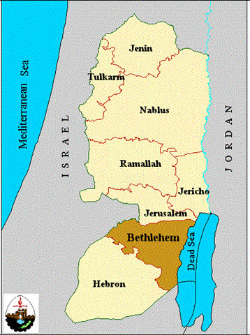
The Bethlehem District is located eight kilometers south of Jerusalem City, in the southern part of the West Bank. It is bounded by the Hebron District to the south and south-west, the Dead Sea to the east, and Israel to the west (Figure 1). ).
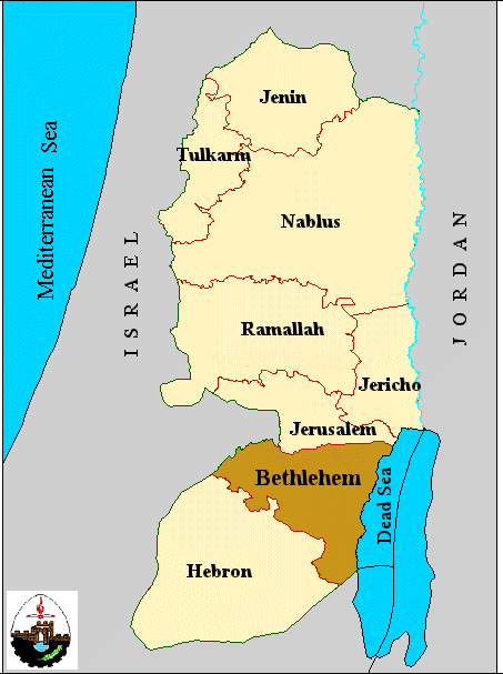
.Figure 1: Map showing location of Bethlehem District
The Bethlehem District has a total area of 605 km², and includes the major municipalities of Bethlehem, Beit Jala, and Beit Sahour, 65 Palestinian towns and villages, the three refugee camps of 'Aida, El-Daheisha, and Beit Jebren, and 27 Israeli settlements. It also includes Israeli-designated closed military areas, military bases, and nature reserves (Table 1). According to the 1997 Palestinian Census, the district's total population is 136,517, including 4,905 refugees, as well as around 50,000 Israeli settlers (Figure 2) .) .
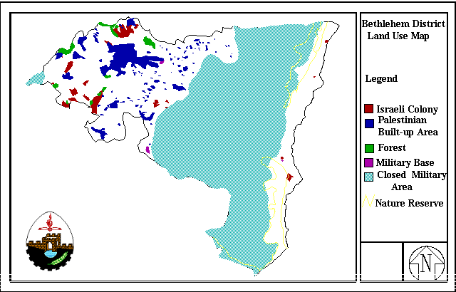
Figure 2: Land use map for Bethlehem district
|
Table 1: Land use classification for the Bethlehem District. |
||
|
Land Use |
Area (Dunums) |
% of Land |
|
Palestinian Built-up Area |
35,900 |
5.9% |
|
Israeli Settlements |
10,730 |
1.7% |
|
Closed Military Area |
310,000 |
51.0% |
|
Military Bases |
4,850 |
0.8% |
|
Nature Reserves |
48,000 |
8.0% |
|
Forests |
3,800 |
0.6 % |
|
Cultivated Area |
43,000 |
7.2% |
|
Other |
125,810 |
21.0% |
|
Confiscated Land |
22,690 |
3.8% |
|
Total |
604,780 |
100% |
As is characteristic of the West Bank, the Bethlehem District has great variation in its topography and climate. The Central Highlands of the West Bank cross the area from south to north in the western portion of the district. Beit Jala claims the highest elevation of around 900 m above sea level. From this peak, the elevation drops drastically over the Eastern Slopes reaching a low of 400 m below sea level at the district's eastern border of the Dead Sea. The climate follows the topography, with a semi-arid climate in the west (700 mm annual rainfall) and an arid climate in the east (less than 100 mm annual rainfall). The vast majority of the population lives in the more hospitable western portion of the district.
The unemployment rate in the Bethlehem District is very high, estimated at 40.5%. The major industries in the district are stone cutting, quarrying, agriculture, and tourism. The upcoming Bethlehem 2000 celebrations have led to a heavy investment in infrastructure and hotel construction. This promises to increase the already large role that tourism plays in the local economy.
Since the signing of 1993 Oslo Accords, the Bethlehem District has been divided into three areas:
-
'Area A' means Bethlehem City, Beit Jala, and Beit Sahour, where the Palestinian Authority controls internal security and civil functions;
-
'Area B' means populated villages, camps and other Palestinian built-up areas, where the Palestinian Authority controls civil functions only;
-
'Area C' means all other areas in the district, where Israel still exercises full authority.
|
Table 2: Bethlehem Areas Regarding Oslo Agreement |
||
|
Areas name |
Area (in Dunum) |
% of Land |
|
Area 'A' |
17,500 |
2.9% |
|
Area 'B' |
48,370 |
8.1% |
|
Area 'C' |
538,910 |
89% |
Bethlehem district is not subjected for any areas expansion regarding phase(I) of wye memorandum (For more detail Click Here) . The further redeployment phase is frozen by the Israeli Government.
Occupation and Colonization in the Bethlehem District
As with the rest of the West Bank, the Bethlehem District was under Jordanian Authority following the 1948 War until the 1967 War brought Israeli military occupation to the Palestinians. Following this occupation, the Israeli government began settling its own citizens within the Green Line boundary which demarcates the West Bank. This move to establish a Jewish presence in the Palestinian Territories was in clear violation of international law, specifically the Fourth Geneva Convention, Article 49, item 6, which states: 'The occupying power shall not deport or transfer part of its own civilian population into the territory it occupies.'
There are currently 27 Israeli settlements in the Bethlehem District. The majority of these (63%) were established under Likud governments, whereas the other 37% were established under Labor governments (Table 2). One of these was established as recently as late-January 1999. The majority of these settlements are located to the north, west, and south of the tri-city area of Bethlehem, Beit Jala, and Beit Sahour.
|
Table 3: Israeli settlements in the Bethlehem District. |
|||||
|
Settlement |
Year Established |
Government |
Location |
Area (Dunums) |
Population |
|
Allon Shevut |
1971 |
Labor |
South-West |
1,500 |
1,600 |
|
Avenat |
No Data |
No Data |
East |
21 |
No Data |
|
Betar |
1982 |
Likud |
West |
1,075 |
8,500 |
|
Betar Illit |
1989 |
Likud |
West |
875 |
711 |
|
Efrat |
1979 |
Likud |
South-West |
1,083 |
5,700 |
|
'Ein Fashkha |
No Data |
No Data |
North-East |
59 |
No Data |
|
El'Azar |
1975 |
Labor |
South-West |
358 |
450 |
|
El David |
1982 |
Likud |
Central |
30 |
175 |
|
Geva'ot |
1982 |
Likud |
West |
50 |
No Data |
|
Gilo |
1970 |
Labor |
North |
2,150 |
30,200 |
|
Giv'at HaDajan |
1997 |
Likud |
South-West |
No Data |
No Data |
|
Giv'at Hahesh |
1998 |
Likud |
South-West |
No Data |
No Data |
|
Giv'at Hamatos |
No Data |
No Data |
North |
172 |
No Data |
|
Giv'at Hazayit |
1997 |
Likud |
South-West |
No Data |
No Data |
|
Giv'at Yitmar |
1997 |
Likud |
South-West |
No Data |
No Data |
|
Hadar Betar |
1978 |
Likud |
West |
10 |
300 |
|
Har Gilo |
1976 |
Labor |
North |
325 |
350 |
|
Kefar 'Ezyon |
1967 |
Labor |
South-West |
933 |
470 |
|
Ma'ale 'Amos |
1981 |
Likud |
South |
175 |
400 |
|
Mizpe Deragot |
1991 |
Labor |
East |
100 |
No Data |
|
Mizpe Shalem |
1977 |
Labor |
East |
383 |
175 |
|
Neve Daniyal |
1982 |
Likud |
South-West |
3,000 |
327 |
|
Noqedim |
1982 |
Likud |
Central |
242 |
263 |
|
Rosh Zuirm |
1969 |
Labor |
South-West |
625 |
260 |
|
Teqo'a |
1977 |
Labor |
Central |
300 |
1,000 |
|
near Bet Iyen |
1998 |
Likud |
South-West |
No Data |
No Data |
|
near Ma'ale Amos |
1999 |
Likud |
South |
No Data |
No Data |
Strangulation of Bethlehem City
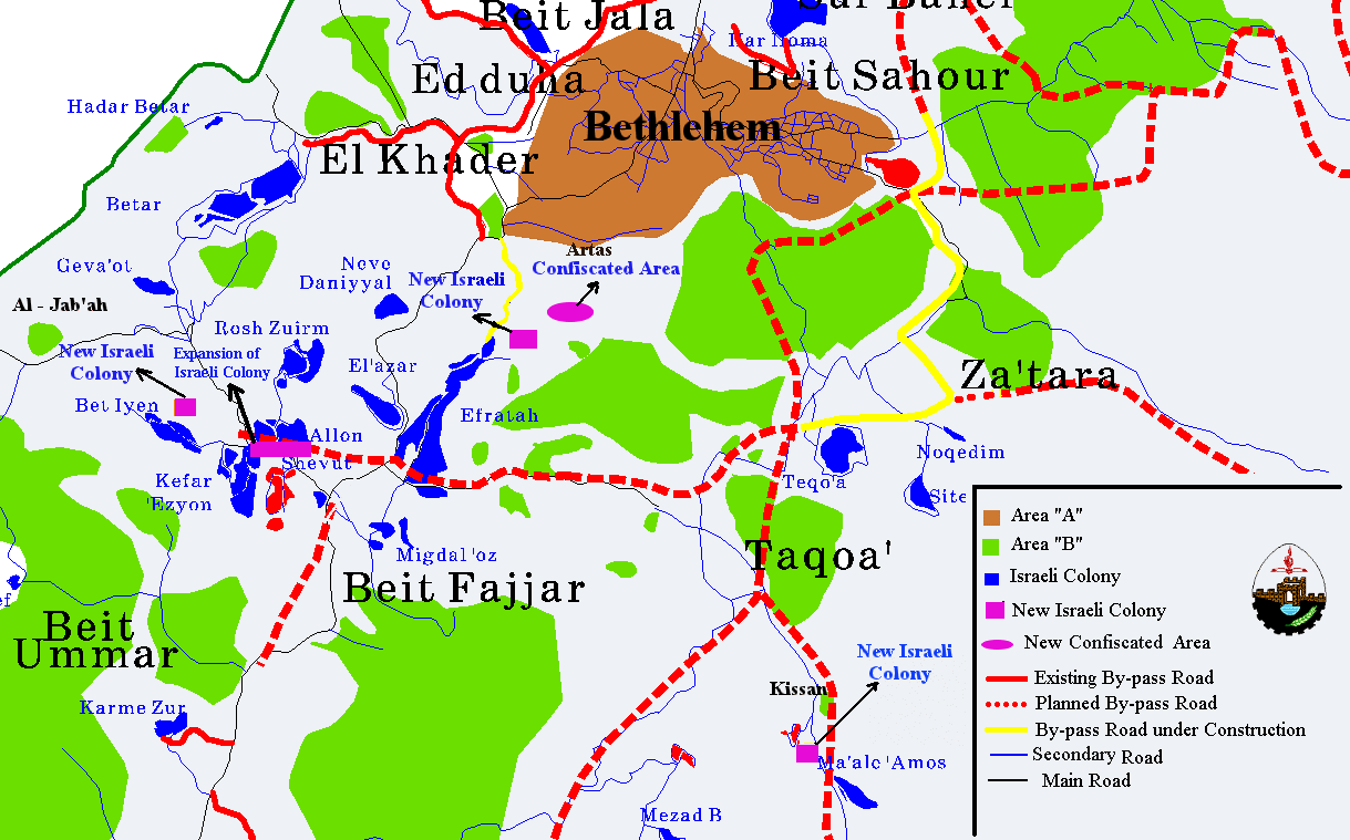
Due to its proximity to Jerusalem and its obvious touristic appeal, the city of Bethlehem has been the subject of massive colonization by the Israelis. Numerous Israeli settlements encircle the tri-city area, essentially strangling the city. Bethlehem is therefore prohibited from expanding to account for natural population growth, as well as being cut off from the surrounding Palestinian communities (Figure 3). ).

Figure 3: The Strangulation of Bethlehem.
This encroachment is led by a block of 13 settlements, called the Gush Etzion Block, to the south-west of the city. Westward expansion is prohibited by several settlements, including Betar, Betar Illit, and Hadar Betar, as well as by three by-pass roads.
Directly north of the city are the settlements of Gilo, Har Gilo, and Giv'at Hamatos. These sprawling suburban settlements are part of the Israeli plan to expand West Jerusalem into the Bethlehem District as part of 'Greater Jerusalem.' The infamous Har Homa settlement is also being planned by the Israelis on Abu Ghnaim mountain to the north of Bethlehem. If this settlement is allowed to be created, along with the fenced military road that is being built to connect it to the other settlements, the entire northern border of Bethlehem will be cut off from Jerusalem.
The areas to the east and south of Bethlehem are occupied by the settlements of Teqo'a, Noqedim, and El David, and a planned by-pass road that has recently begun construction promises to eliminate any possibility of Palestinian growth.
These Israeli settlements and by-pass roads are creating facts on the ground which will enable Israel to carve most of this area from the West Bank and annex it to Israel (Figure 4) .) .
This measure will diminish the area available for the sustainable development of Bethlehem and eliminate large stretches of agricultural and grazing areas which Palestinian farmers depend on as a major source of income.
Gush Etzion
The Gush Etzion block of settlements includes Allon Shevut, Efrat, El'Azar, Geva'ot, Kefar 'Ezyon, Neve Daniyal, Rosh Zuirm, the new settlements of Giv'at Hazayit, Giv'at HaDajan, Giv'at Hahesh, and Giv'at Yitmar, and Bet Iyen and Migdal 'Oz in the northern Hebron District (For more detail click here). This large settlement block houses over 35,000 Israeli settlers, and is threatening to expand (Figure 5) .

Figure 5: Continuous Expansion of Gush 'Etzion Block.
The Gush Etzion colonization first began with the construction of Kefar 'Ezyon following the 1967 War. Colonization activity in this area has continued throughout the occupation due to the abundant water resources in the region and its location between the major Palestinian city of Bethlehem and the Green Line. Most of the Gush Etzion block is built on land originally belonging to the Palestinian villages of Al-Khader and Nahalin.
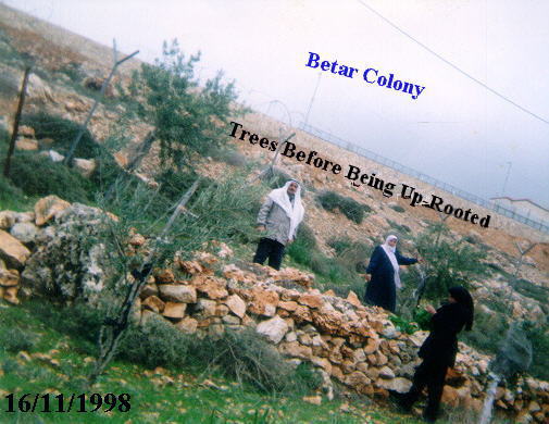
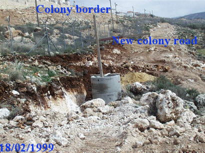
Nahalin, situated 20 kilometers south-west of Bethlehem, originally comprised an area of 12,000 dunums. Since 1967, 60% of this area has been confiscated by the Israeli authorities in order to build more illegal settlements. With the Gush Etzion block of settlements to the south and the growing Betar and Betar Illit settlements to the north, Nahalin, and the nearby villages of Wadi Fukin and Husan, are under increasing threat of being completely encircled (Figure 6) .) .
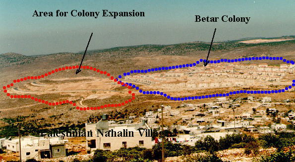
Figure 6: Growth of Betar settlement toward Nahalin Village.
This will result in the Palestinian people being forced to use vital agricultural land in order to extend the village, ultimately resulting in the creation of an urban, rather than agricultural, community. The end result of land confiscation and the building of settlements will be the complete isolation of the village of Nahalin (Figure 7) .) .

Figure 7a: Satellite image showing the encirclement of Nahalin Village.
More over , On February 17 , Jewish settlers from Betar settlement Guarded by Israeli army uprooted approximately 200 olive trees owned by Nahailn farmers in order to facilitate a road which serves the settlement infrastructure. All the uprooted trees were later on confiscated to efface the settlers criminal activities.
Figure 7 (a, b & c): Recent Colonist activity in Nahalin Village

The expansion of the Gush Etzion block could impose a similar fate upon Bethlehem, preventing any contiguity between Bethlehem, Hebron, and the many smaller Palestinian communities in the southern West Bank.
Abu Ghnaim
Abu Ghnaim mountain is located less than two kilometers north of the city of Bethlehem. The mountain has been historically owned by Palestinians from Bethlehem and Beit Sahour, as well as from the villages of Um Tuba and Sur Baher. The geographical location of the mountain gave it such importance that Israel decided in 1967 to unilaterally carve it out of the Bethlehem District, extending the Jerusalem Municipal boundaries in such a jagged manner as to include Abu Ghnaim .
Abu Ghnaim represents an ecological reserve in an area characterized by a deteriorating environment and increasing desertification. For many years, Abu Ghnaim and its surrounding areas were designated by the Israeli Jerusalem Municipality as a 'Green Area.' This designation prohibits development so that the beauty of the landscape, as well as ecological diversity, might be preserved. Israel often uses this designation to restrict Palestinian construction and prevent the expansion of Palestinian communities located in the vicinity of settlements.
On 6 June 1991, the Israeli government ordered the expropriation of Abu Ghnaim for the construction of the Har Homa settlement. This settlement was expected to accommodate thirty to forty thousands Jewish settlers. Despite the Israeli 1962 Forest Ordinance which protects forested areas similar to that of Abu Ghnaim and declares pine trees as protected trees, Har Homa settlement was approved by the Israeli government without consideration of performing an environmental impact assessment.
The construction of Har Homa has been repeatedly delayed due to Palestinian legal objections and disputes between Israeli contractors (Figure 8 A). The infrastructure for the settlement, however, has already been constructed. The roads criss-crossing through this former ecological haven stand as a symbol of Israeli destruction of Palestinian land (Figure 8 B). The Israeli government has also begun construction of a fenced military by-pass road to provide access to Abu Ghnaim mountain. The lengthy by-pass road awkwardly winds its way around Palestinian built-up areas, and consumes large tracts of fertile Palestinian agricultural land.). The Israeli government has also begun construction of a fenced military by-pass road to provide access to Abu Ghnaim mountain. The lengthy by-pass road awkwardly winds its way around Palestinian built-up areas, and consumes large tracts of fertile Palestinian agricultural land.). The infrastructure for the settlement, however, has already been constructed. The roads criss-crossing through this former ecological haven stand as a symbol of Israeli destruction of Palestinian land (). The Israeli government has also begun construction of a fenced military by-pass road to provide access to Abu Ghnaim mountain. The lengthy by-pass road awkwardly winds its way around Palestinian built-up areas, and consumes large tracts of fertile Palestinian agricultural land.
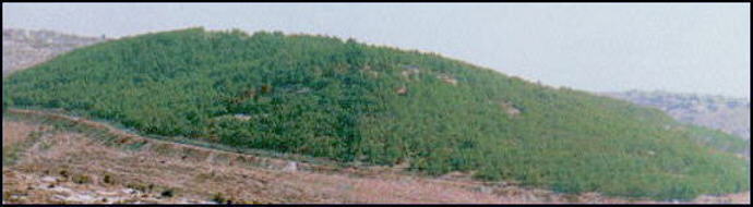
Figure 8 a: Abu Ghnaim mountain before starting any colonizing activity
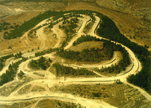
Figure 8 b: Settlement roads criss-crossing Abu Ghnaim mountain.
Abu Ghnaim previously hosted around 60,000 pine trees and provided an oasis for several hundreds of precious wild animals and plants. It also has religious significance, hosting many Christian holy sites, including St. Theodore's Well, the 5th and 6th century Byzantine monastery and church of Bir Qadisum, which marks the place where St. Mary dismounted before giving birth to Jesus, and is very close to the Christian traditional site of the Shepherd's Fields. Some even believe that Abu Ghnaim itself is the site of the Shepherd's Fields.
The Israeli government, under the leadership of Prime Minister Benjamin Netanyahu, has recently ordered the construction of Har Homa to continue. Tenders for the construction of the settlement went out on 12 November 1998. This announcement occurred despite the signing of the Wye Agreement three weeks earlier which denounced any such activity.
The tri-city of Bethlehem, Beit Jala, and Beit Sahour will be left with little land to accommodate natural population growth if Har Homa settlement is constructed. The building of Har Homa and the fenced military by-pass road which will connect it with the neighboring Gilo settlement will deprive Bethlehem of the only land left for its future development. This by-pass road will also shift the border of Jerusalem further south and deeper into the Bethlehem area. The Har Homa settlement will also ensure that Israel deprives the Palestinians of Bethlehem of their main source of income: tourism. The Har Homa project includes the building of a tourist village, Bethlehem Israel, to attract the Christian tourists who come to visit the Church of Nativity in Bethlehem (Figure 9).).
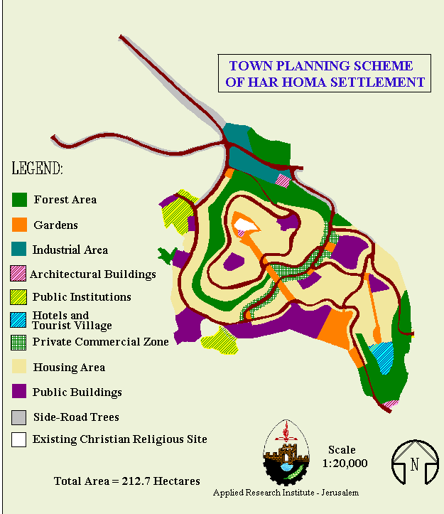
Figure 9: Planning scheme of Har Homa.
By-pass Roads
By-pass roads are built for the use of Israeli settlers, to link Israeli settlements to each other and with Israel, and to avoid contact with Palestinians. A 75 m 'safety zone' on either side of these roads restricts Palestinians from any type of construction activity. The construction of these roads also serves the purpose of fragmenting Palestinian land and people (Figure 10). ).
Figure 10: Israeli by-pass roads in the southern part of West Bank.
There are numerous existing by-pass roads in the Bethlehem District, and many more being planned by the Israeli government. 42 homes that sit along existing or planned bypass roads in the district are already slated for demolition. Road 60 is the largest and most invasive of these roads. It cuts through and encircles Palestinian built-up areas, threatening to cut off communities from each other and consuming large tracts of land. The largest tunnel in the Middle East was dug through the center of Beit Jala as part of Road 60 so that Gush Etzion settlers could avoid any contact with Palestinians from Bethlehem.
The Palestinian village of Al-Khader, situated 3 kilometers south of Bethlehem, is under increasing threat from the expansion of road 60. A 3 km expansion of the road which began construction in November 1998 will completely destroy 4,000 dunums (1 dunum = 1/10 hectare) of Al-Khader land, with another 1,000 dunums being lost to the buffer zone. More than 10,000 trees will be uprooted and 500 dunums of agricultural landwill be bulldozed due to this construction (Figure 11).
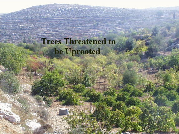
Figure 11: The Threatened Agricultural Land
The original area of the village was 22,000 dunums, but, since 1967, 55% of this area has been confiscated by the Israeli authorities to build more illegal settlements or to construct by-pass roads. The Israeli High Supreme Court of Justice told the municipality of Al-Khader that they would have to pay 30,000 NIS in order to lodge an appeal to this road construction. Past precedent indicates that any such appeal would be destined to fail.
In addition to Road 60, there are two other by-pass roads west of Bethlehem which serve Israeli settlers and cut off Palestinians from their land. Three new by-pass roads are also planned to the south and east of Bethlehem (Figure 10). Route 369, directly to the east of the city, is to begin construction in early 1999. One of these planned by-pass roads, Route 80, has been in the planning stage for years, but was only approved by the Israeli security cabinet in November 1998, two weeks after the signing of the Wye Memorandum. Although Israeli environmentalists, traffic experts, and settlers alike do not support the construction of this road which will traverse all of Israel from north to south, it is a favorite of Israeli Foreign Minister Ariel Sharon. Mr. Sharon developed the plan for this road when he was Defense Minister in the early 1980's, and pushed for its construction after becoming the Foreign Minister shortly before the Wye talks. He sees this as the eastern border for any Palestinian State. ). Route 369, directly to the east of the city, is to begin construction in early 1999. One of these planned by-pass roads, Route 80, has been in the planning stage for years, but was only approved by the Israeli security cabinet in November 1998, two weeks after the signing of the Wye Memorandum. Although Israeli environmentalists, traffic experts, and settlers alike do not support the construction of this road which will traverse all of Israel from north to south, it is a favorite of Israeli Foreign Minister Ariel Sharon. Mr. Sharon developed the plan for this road when he was Defense Minister in the early 1980's, and pushed for its construction after becoming the Foreign Minister shortly before the Wye talks. He sees this as the eastern border for any Palestinian State.
The construction of these by-pass roads, along with the completion of the half-finished military road connecting Abu Ghnaim to other settlements, will completely encircle the Bethlehem tri-city area. This action will severely limit the development and endanger the future of this historic city.
House Demolition
The demolition of Palestinian homes has been an Israeli policy since the 1948 War. Following the establishment of the State of Israel, the Israeli government passed a series of discriminatory zoning and ownership laws allowing for hundreds of 'illegal' Palestinian homes to be demolished. These policies carried over to the West Bank after the 1967 War (Figure 12).).

Figure 12: Palestinian child stands over the debris of her home in Al-Khader Village.
Palestinian homes in the West Bank are demolished under the pretext of one or more of three reasons: security violation, zoning violation, or the lack of a proper building license. Since the signing of the Oslo Accords in September 1993, the rate of demolition has increased dramatically. According to official figures from the Israeli Ministry of Defense, demolition of homes has stepped up drastically since the election of Prime Minister Benjamin Netanyahu, with demolitions in 1997 alone surpassing the total number from the signing of Oslo until the defeat of the Labor party in 1996 (Table 3).
|
Table 4: House demolitions by year and government in the West Bank including Jerusalem. |
||||
|
Government |
September 1993 – June 1998 |
1997 |
January – June 1998 |
|
|
Labor |
197 |
– |
– |
|
|
Likud |
372 |
249 |
101 |
|
|
Total |
569 |
249 |
101 |
|
|
(Data compiled from Defense Minister Yitzhak Mordechai and LAW) |
||||
In 1997 and 1998, every home demolished in the West Bank was located within Area C. The fact that there is no known instance of the Israeli government issuing a building permit to a Palestinian living in Area C seriously undermines any Israeli claim to the legal legitimacy of its zoning and demolition policies.
From the signing of the Oslo Accords in 1993 until the end of 1998, 77 houses have been demolished in the Bethlehem District. Every Monday and Thursday Israeli helicopters survey the district for any new buildings that fall outside of area A (Figure 13). ).

Figure 13: Map showing demolished houses in the southern part of the West Bank.
It seems that the Israeli government is initiating a new house demolition campaign in the Bethlehem District for 1999 . On 27 January 1999, the Israeli government issued demolition notices to 16 houses in the town of Al-Khader south of Bethlehem. The demolitions are to take place on March 1. One of the threatened buildings is a Palestinian school which promotes Jewish-Arab coexistence. The Hope Flowers school was founded in 1984, and was visited by Hillary Clinton, wife of U.S. President Bill Clinton, when she came to Israel in December 1998. The top two floors of the school, the kitchen, and the front yard are scheduled for destruction due to being built without a permit.
The village of Kissan in the southern Bethlehem District is under an even heavier threat. All of the houses in the village are threatened to be demolished. This is the second time the village has been under such a threat. In 1987, the entire village was destroyed and moved across the road. Kissan is predominantly populated by Bedouin families who have been forced into settling in the village by the Israeli military. Palestinian Bedouins are frequently targeted by the Israeli military due to their traditional nomadic way of life. The small Bedouin community of Al-Rawa'in outside of Kissan is commonly harassed by the Israeli military. Israeli soldiers from the nearby military base have taken their sheep without any reason, and perform military exercises amidst their houses.
Loss and Pollution of Agricultural Land
In 1967 Israel unilaterally expanded the borders of East Jerusalem to include about 16 km² from Bethlehem. This practice of land confiscation has been an ongoing policy of the Israeli government. From the signing of the Oslo Accords in 1993 until the end of 1998, 22,694 dunums of land have been confiscated and 12,276 trees have been uprooted in the Bethlehem District by the Israeli military. Most recently, in December 1998, hundreds of dunums were confiscated from the town of Artas, south of Bethlehem, in order to expand the settlement of Efrat.
In order to justify these illegal confiscations, the Israeli military uses the rational of security reasons or the Absentee Law. This law is a re-working of former Ottoman, British, and Jordanian laws, which the Fourth Geneva Convention states must be used by the occupying force. Whereas the original laws stated that those who settle and utilize an area of land for ten years or more are entitled to possession of that area of land, the Israeli government has twisted them around to declare any land which has not been used for ten consecutive years as property of the state.
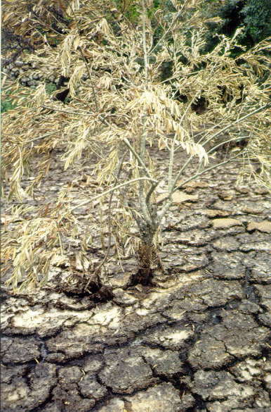
Much of the land that Israel declares as 'not in use' is actually used for rainfed farming by a large percentage of the Palestinian population. The confiscation of this land and the removal of its olive trees has taken away the livelihood of many Palestinian families. Furthermore, much agricultural land is being polluted by the disposal of untreated wastewater from Israeli settlements (Figure 14). The location of most of the settlements on hilltops overlooking Palestinian towns has meant that their waste and sewage flows into the Palestinian agricultural land found in the soil-rich valleys below them (Figure 15). ). The location of most of the settlements on hilltops overlooking Palestinian towns has meant that their waste and sewage flows into the Palestinian agricultural land found in the soil-rich valleys below them .
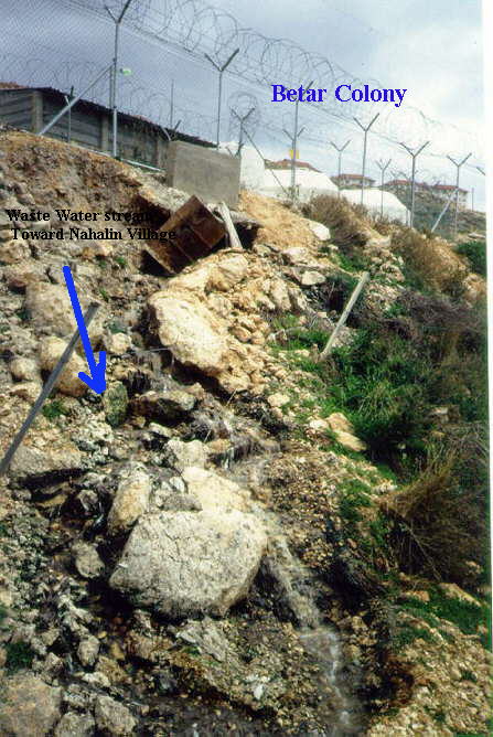
Figure 14: Sewage stream from Betar settlement through Palestinian land.
Water Shortages
Palestinian Water Authority (PWA) officials report that the southern portion of the West Bank is experiencing a water shortage whereby the need for water is three times that which is being provided by Israel. This has largely been caused by the failure of the Israeli water corporation, Mekerot, to supply water per the amounts agreed to in the Water Annex of the Oslo Accords. The Oslo II Agreement stipulates that the future water needs of Palestinians in the West Bank are between 70-80 MCM/year of fresh water. It was also agreed that the immediate need of the Palestinians for domestic water use during the interim period is 28.6 MCM/year. After more than three years since the signing of the agreement, Israel has only supplied an additional 7 MCM of water per year of the 80 million to which it has committed itself.
While Palestinians are struggling to connect the remaining 20% of the population in Palestine to household water-distribution systems, Jewish settlers in the West Bank receive continuous water supply, largely from groundwater wells in Palestine. The PWA has stated that the amount of water supplied by Israel to the Bethlehem and Hebron Districts has decreased from 33,000 CM a day to 20,000 CM a day in order to meet settler needs. During the dry summer periods, Palestinian communities are left without water for extended periods of time. In contrast, nearby settlements have enough water to keep their lawns green and their swimming pools full of fresh water. Average annual per-capita water consumption for West Bank settlers is 650 CM, as opposed to 107 CM in Palestinian areas.
This water shortage has caused the development of a black market in water during the summer months. Water is stolen from wells and springs and sold to needy families at the exorbitant price of 25 NIS per CM. Palestinian families in Bethlehem, some of whom only receive water in trucks once every ten days during the summer, are forced out of desperation to pay such prices.
Over-Exploitation of the Eastern Slopes and Dead Sea
The sparsely populated eastern section of the Bethlehem District, comprising the Eastern Slopes and the Jordan Valley, are also undergoing harsh treatment by the Israeli government. The reason for this small population is that the vast majority of the land is declared as a closed military area or nature reserve by the Israeli government. Although this area has traditionally been used as the major grazing land for Palestinian herders, it has been closed to all types of Palestinian use since 1967. This has caused the massive desertification of the remaining 15% of grazing land which the herders are now forced to use.
Although the designation of part of this land as a nature reserve is an important step in preserving this ecologically sensitive area, it appears that these decisions are frequently made without the environment in mind. These nature reserves are almost exclusively found in the Jordan Valley, an area which Israel has long attempted to keep as a buffer zone between Palestinians and Jordan, in exclusion of the many other environmentally sensitive areas of the West Bank. Meanwhile, the rest of this area is being used as a training site for destructive military practices. Nature reserves have also been used to hold back Palestinian construction until such time that Israeli settlers are ready to build. This has been observed at Abu Ghnaim, as well as at several sites in the Jordan Valley. Most recently, the peace process has been delayed due to the Israeli insistence that a large portion of the eastern Bethlehem District remain designated as a nature reserve. This issue served as a stalling tactic for the Israeli government until the U.S. brokered Wye talks laid it to rest.
The Dead Sea itself is also the subject of abuse. Over the past year alone the water level of the Dead Sea has dropped by one full meter. The southern basin of the Dead Sea has been destroyed over the past 30 years through industrial mineral extraction by the Israeli Dead Sea Works and the Jordanian Arab Potash Company. This process involves the construction of large evaporation ponds which have turned extensive portions of the Dead Sea into mud flats. Meanwhile, the northern basin, which is largely located in the Bethlehem District, is being developed by the Israeli government into one large tourist complex. This high rate of industrialization and construction, combined with the diversion of 90% of the waters from the Jordan River, are threatening the very existence of this globally unique environment.
After the Wye Memorandum
Since the signing of the Wye River Memorandum on 23 October 1998, the Israeli government has not stopped its unilateral practices in the West Bank of creating de facto realities on the ground. These unilateral actions are against the word and the spirit of the Wye Agreement, as well as being in total violation to United Nations' resolutions 298 and 242, and other standing Palestinian-Israeli Agreements.
Chapter two, Article 31, item 7 of the Israeli-Palestinian Interim Agreement on the West Bank and the Gaza Strip (Oslo II) states that:
'neither sides shall initiate or take any step that will change the status of the West Bank and the Gaza Strip pending the outcome of the permanent status negotiations.'
Article V of the Wye Agreement on Unilateral Actions states:
'Recognizing the necessity to create a positive environment for the negotiations, neither side shall initiate or take any step that will change the status of the West Bank and the Gaza Strip in accordance with the Interim Agreement.'
As reported above, the State of Israel has committed numerous infractions of these agreements in the Bethlehem District during recent months, including:
-
Issuing tenders for the construction of the infamous Har Homa settlement on Abu Ghnaim mountain, north of Bethlehem.
-
Expanding Road 60 at the expense of Palestinian land in the town of Al-Khader, south of Bethlehem.
-
Initiating a house demolition campaign within the town of Al-Khader, south of Bethlehem.
-
Initiating construction of by-pass road 369, east of Bethlehem.
-
Approving the construction of Route 80.
-
Confiscating hundreds of dunums from the town of Artas, south of Bethlehem.
In addition, three new settlements have recently been erected within the Bethlehem District. After signing the Wye River Agreement, Jewish settlers seized dozens of strategic hilltops to keep land out of Palestinians hands. The confiscated land is predominantly on hilltops near existing settlements, in areas that are likely to become subject to negotiation in final status talks. On 26 January 1999, nine caravans were set-up on Palestinian land near Kissan in southern Bethlehem District (Figure 16). This new settlement is located strategically between the settlement of Ma'ale Amos and an Israeli military base, as well as being near the proposed by-pass road 80. ). This new settlement is located strategically between the settlement of Ma'ale Amos and an Israeli military base, as well as being near the proposed by-pass road 80.
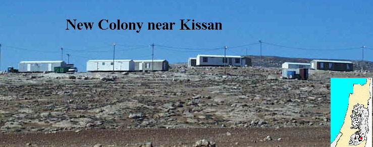
Figure 16: New settlement near the Palestinian village of Kissan.
On 9 November 1998, settlers from Gush Etzion took over land south-west of Bethlehem near Allon Shevut to construct a settlement called Giv'at Hahesh. Seven mobile homes were set up on a hill one kilometer east of the Allon Shevut settlement. Jewish settlers also erected three caravans on a hilltop near the Israeli settlement of Bet Iyen on 22 November 1998 (Figure 17). This recent colonization activity further expands the Gush Etzion Block of settlements, and threatens to completely separate the surrounding Palestinian communities. ). This recent colonization activity further expands the Gush Etzion Block of settlements, and threatens to completely separate the surrounding Palestinian communities.
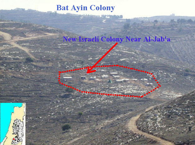
Figure 17: New settlement south-west of the city of Bethlehem.
Conclusion
With the coming 2000th anniversary of the birth of Jesus Christ, the Bethlehem District is alive with activity. Unfortunately, much of this activity involves the confiscation of Palestinian land, demolition of Palestinian houses, and creation of new Israeli settlements. Although such illegal activities on the part of the Israeli government have been occurring throughout the occupation, their efforts in the Bethlehem District have intensified in recent months.
The signing of the Wye Memorandum on 23 October 1998, instead of initiating a new era of peace, has heightened Israeli attempts to colonize the Palestinian Territories. In the Bethlehem District this has meant the construction of more by-pass roads, the demolition of Palestinian houses, the confiscation of Palestinian land, and the creation of four new settlements, including the infamous Har Homa settlement.
If these Israeli actions are allowed to continue as they are currently planned, the city of Bethlehem will be completely cut off from its neighboring communities and historic ties. In what should be a year of peace and celebration in Bethlehem, the Israeli government is turning into a year of aggression and worry for the Palestinian people.
Prepared by:
The Applied Research Institute – Jerusalem