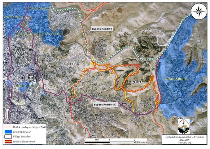
An Israeli Road Network to be constructed on lands of Al Ezariyeh and At-Tur communities
The Israeli Occupation Army handed out residents of El Ezariyeh and At-Tur cities, Palestinian suburbs southeast of occupied East Jerusalem ...
The Israeli Occupation Army handed out residents of El Ezariyeh and At-Tur cities, Palestinian suburbs southeast of occupied East Jerusalem ...
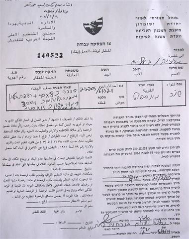
The reason stated in the demolition notices is that the residential houses were built in area C (where Israel has ...
The Israeli occupation authorities handed over two demolition notifications against agricultural installations in the village of Jinsafut, Qalqiliya governorate under ...
Photo 1: Ar Ras quarter- Idhna- Hebron: an Israeli bulldozers demolishing a poultry farm) One poultry farm ...
(Photo 1: Farsh Al Hawa-Hebron: A piece of land Palestinian owned land confiscated & leveled for the erection of watch ...
Since the midnight of February 6th, 2007, Israeli security forces (including Police, Border Police, Intelligence, etc) have placed a strict ...
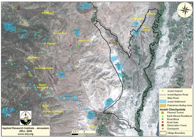
Location & Population Al Jiftlik, a Palestinian village located to the north of Jericho Governorate at the central part of ...
On December 19, 2006 the Israeli Occupation Army commenced constructions at Tayaseer checkpoint located to the east of Tubas city ...
A repository of the trash where Israeli settlers get rid of their garbage is arousing peoples' concern in the village ...
A repository of the trash where Israeli settlers get rid of their garbage is arousing peoples' concern in the village ...
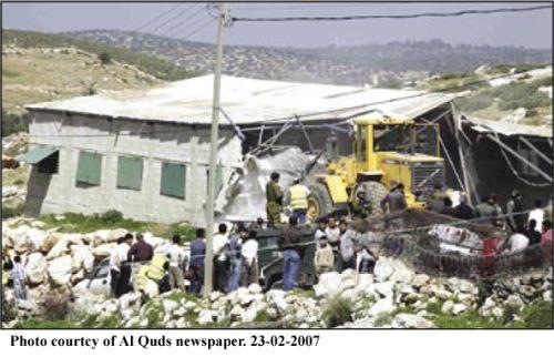
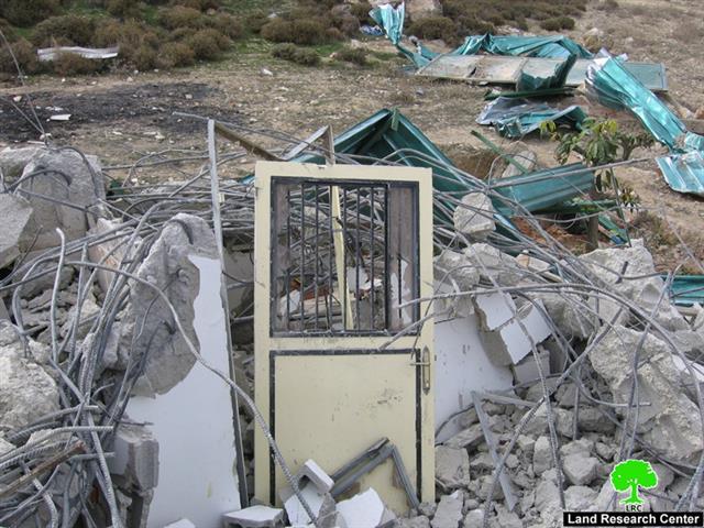
(Photo 1: Mt. of Olives-Jerusalem: the ruins of the demolished house of Mrs. Malook Kazem Abdullah, a mother of 11) ...
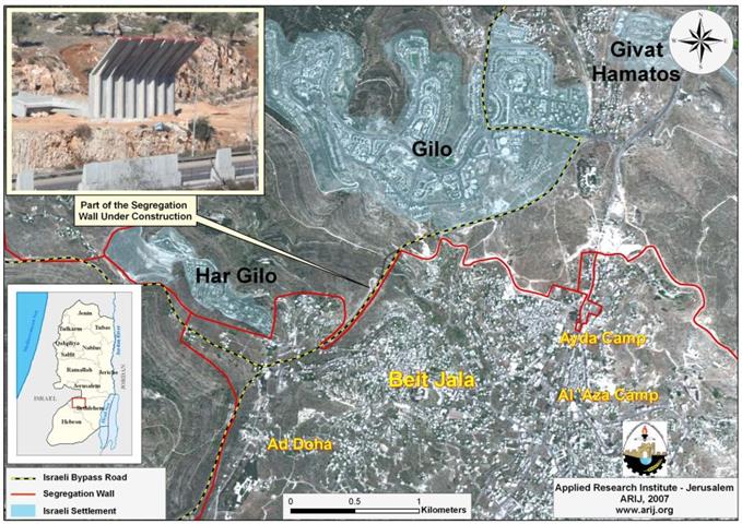
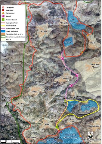
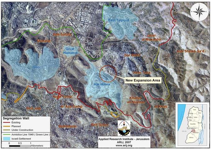
The Israeli occupation bulldozers commenced last month 2007 the construction of the Segregation Wall north of Beit Jala city at ...
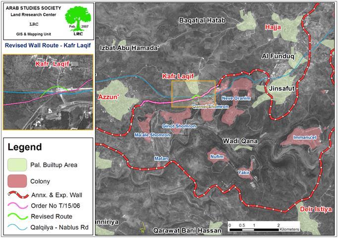
The Israeli occupation army issued an a amendment for the military order number T/15/06 stating the confiscation of an additional ...
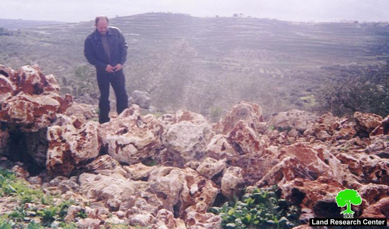
(Photo 1: A resident of Kafr Qaddum standing atop a pile of rocks blocking an agricultural road in the village ...
Right after the time of the Annapolis meeting, which was held in the US state of Maryland in November 26, ...
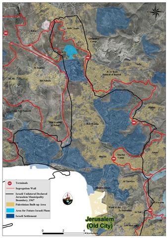
On February 1, 2007, the Israeli Prime Minister Ehud Olmert, has approved a plan to reroute a section of the ...
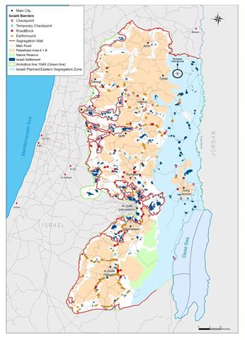
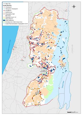
General Glance When Israel and the PLO (Palestinian Liberation Organization) signed the Declaration of Principles DOP back in 1993, Israel ...
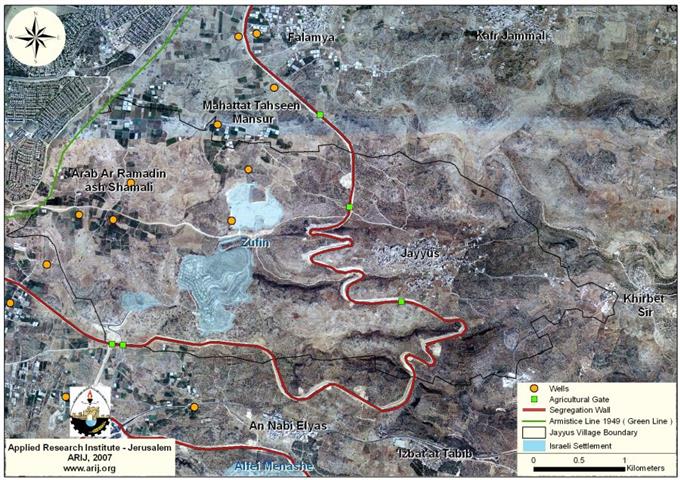
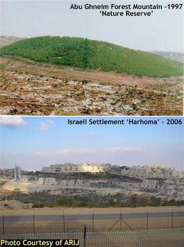
Qalqiliya, 1970, 1997 & 2005 Following the Israeli Attack on Palestinian residential Territory in the 1948 war, in which Israel ...
Qalqiliya, 1970, 1997 & 2005 Following the Israeli Attack on Palestinian residential Territory in the 1948 war, in which Israel ...
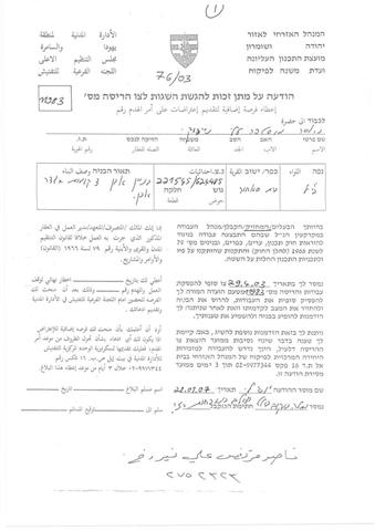
بتاريخ 29 , كانون الثاني, 2007 , قامت سلطات الاحتلال الاسرائلي بتسليم 11 اخطارا لهدم بيوت و بركسات ...
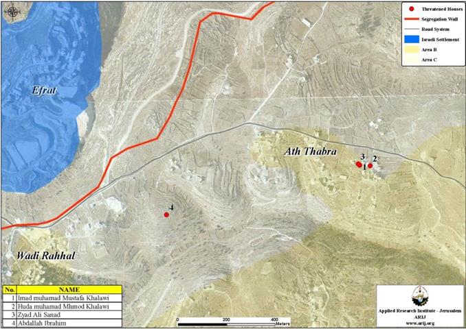
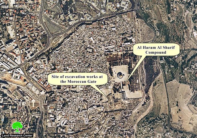
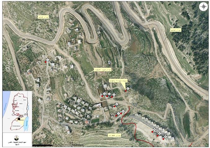
On January 28, 2007, the Israeli Occupation Army handed out 11 military notices to residents of the Orthodox Housing Complex project ...
لا تزال قوات الاحتلال الاسرائيلي و منذ احتلالها للضفة الغربية و قطاع غزة في العام 1967 ...
After people, trees and all kinds of plantations are considered the worst of enemies to any occupation, in our case ...
Israeli Occupation forces handed out residents of Beit Iksa, Nabi Samuel and Beit Surik a new military order stating the ...
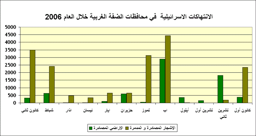
This report highlights the chronology of events concerning the Israeli Colonizing Activities in the West Bank, Jerusalem and the Gaza ...

........................................................

........................................................

........................................................

........................................................

This website and its content were initiated in 1993 by the Applied Research Institute – Jerusalem (ARIJ) and the Land Research Center (LRC) with the support from the European Union up until 2023. Since then, the Applied Research Institute – Jerusalem (ARIJ) has taken over the continued development and maintenance of the website. The views expressed remain solely those of ARIJ) and do not necessarily reflect those of the European Union.