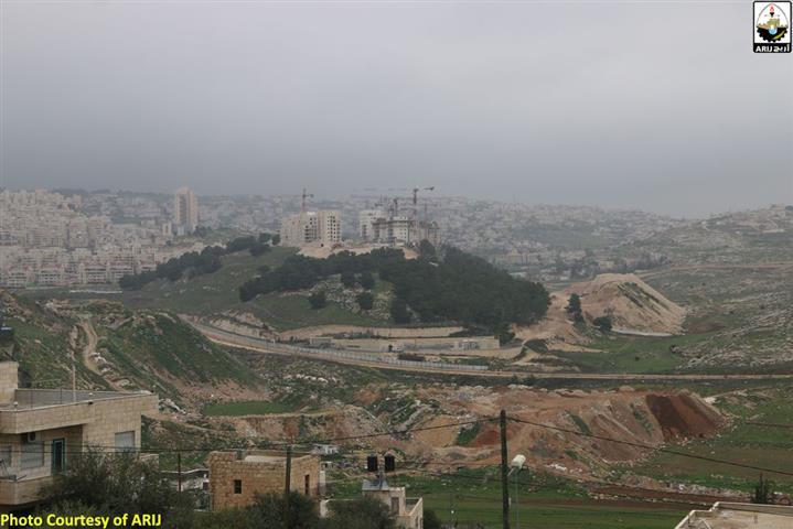
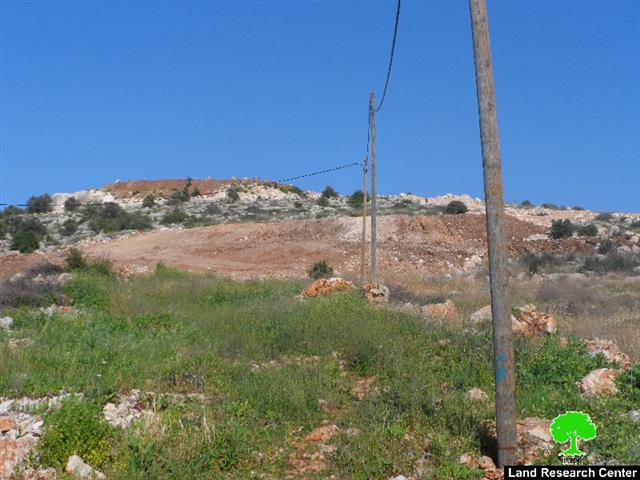
Since the beginning of 2016, Israeli machinery and bulldozers started leveling lands to the southeast of Har Homa settlement (locally known Abu Ghneim mountain) belonging to Palestinian families in Beit Sahour city for the favor of expanding the settlement. The expansion activity comes as par of town planning scheme No. 10310 which states the construction of a new neighborhood to the southeast of Har Homa, on 303 dunums of lands, with a total of 930 new[1] settlement units. The targeted land is isolated behind the Israeli segregation Wall and is undergoing extensive construction.
Implementation and construction of Plan No. 10310 started in mid-2014 and continues until this day. Huge buildings can be seen in the site of construction. So Far, around 15 huge buildings were built in the site and several roads were also constructed to allow access within the neighborhood. It is planned that the area around the new neighborhood from the east, west and south will be preserved as open spaces for public. See Photos 1-2
Photos 1-3: Expansion undergoing in Har Homa Settlement
“Expanding Har Homa settlement westwards”
Har Homa west settlement plan
The Jerusalem Municipality website indicated that Israel is planning for a new settlement to the west of Har Homa settlement, identified as “ Har Homa West ”. The new settlement is planned to include 1600 new settlement units over total land area of 445 dunums, to the south of Saint Elias Monastery. See Map 1
During the past few years, Israel started constructing a new bypass road which extends from the northwest end point of Har Homa settlement towards Bethlehem-Jerusalem Road, to connect with the Tantour Junction. The construction of this new bypass road serves the Israeli plans in the area, which is to establish the aforementioned new settlement.
The construction of the road comes as part of TPS number 12626 which states the confiscation of 141.7 dunums of land for the construction of the aforementioned bypass road. The plan was first deposited on the 26th of September 2011 and construction work commenced right after it gained the approval of the designated Israeli Authorities.
Note that TPS No. 5053 was the first town planning scheme (TPS) issued for Har Homa settlement on the 2nd of March 1997. The plan included the development of an urban residential with all issues related to it on lands of Beit Sahour, Bethlehem, Sur Baher and Um Tuba in Bethlehem and Jerusalem Governorate, on the part located within the illegally and unilaterally declared Jerusalem Municipality boundary of 1967. The plan stated the construction of a new settlement (Har Homa) over 1992.3 dunums of land to encompass up to 6,500 settlement apartments that time. Several plans were issued afterwards commencing the building in the settlement. Today, the settlement stands on 2204 dunums of land and is home to 39382 Israeli settlers. See Table 1 and Map 2 of plans issued in Har Homa Settlement
|
Table 1: Israeli tendered plans in Har Homa settlement south of Jerusalem |
||||
|
No. |
TPS No. |
Area (Dunums) |
No. of Housing Units |
Date of Deposit |
|
1 |
5053 |
1992.3 |
6500 |
2/3/1997 |
|
2 |
7509 |
977.521 |
2653 |
13/3/2003 |
|
3 |
7509B |
10.371 |
Sewage Treatment Plant |
29/12/2005 |
|
4 |
9142A |
34.303 |
Archeological Site |
9/2/2012 |
|
5 |
9701 |
107 |
Construction of Road |
9/7/2006 |
|
6 |
10310 |
303.3 |
930 |
26/9/2011 |
|
7 |
10766 |
85.36 |
Change in Land Uses |
8/7/2010 |
|
8 |
12552 |
65.746 |
|
11/7/2012 |
|
9 |
12626 |
141.7 |
Construction of Road |
26/9/2011 |
|
10 |
12825 |
179.56 |
104 |
26/9/2011 |
|
11 |
12982 |
4.875 |
Change in Zoning |
6/10/2011 |
|
12 |
במ/5053א |
673.6 |
2341 |
30/3/1997 |
|
Source (1): The Israeli Land Administration website |
||||
|
Source (2):TABANOW website |
||||
Map 1: Israeli plans issued for the construction of Har Homa settlement since 1997
Fortifying the path of the Israeli Segregation Wall near Har Homa settlement
On the 28th of October 2015, the Israeli daily newspaper, “Israel Hayom”, published on its website three announcements stating the confiscation of 102 dunums of Palestinian lands in Bethlehem Governorate for public purposes, of which 28 dunums of Beit Sahour city land, the part located within the illegally and unilaterally defined Jerusalem Municipal boundary of 1967.
The announcements, which were signed by the Israeli Finance Minister, Moshe Kahlon, on the 4th of August 2015, were cited as “announcement of the intention to acquire the rights of land and land ownership, required under emergency regulations, for public purposes (with reference to section 5 and section 7 of the Land (Acquisition for Public purposes) Ordinance No. 24 of 1943)”. According to the military order, the acquisition of land is “necessary due to the continuous attacks against the Israeli security in the area around Jerusalem, and to maintain the separation wall which addresses the security threats, and to protect the national security”. Table 2 below gives more details of the published Announcement.
|
Table 2: Targeted locations in Bethlehem Governorate as stated in the published Ads |
||||||
|
No. |
Community Name |
Area (Dunums) |
Targeted location |
Period of land Acquisition |
Plan No. |
|
|
1 |
Beit Sahour |
28.15 |
Har Homa settlement – Beit Sahour city |
10 |
הפ/א/ 322/156 |
|
Plan No. הפ/א/322/156 targets Palestinian owned lands near Har Homa settlement, from its southeastern side, on lands of Beit Sahour. The plan intends to fortify the section of the Israeli Segregation Wall that separates Har Homa settlement from Beit Sahour city. The Israeli finance minister plans to obtain the right of possession and use of the targeted land for ten years.
Photos 5-6: The announcement and map regarding the acquisition of land in Beit Sahour city
Map 2: The the acquisition of land in Beit Sahour, Bethlehem and Beit Jala cities
To conclude,
The process of enhancing settlement building in the occupied West Bank and in particular those located within the illegally declared Jerusalem Municipality Boundary of 1967 contravenes the demographic balance in the city for the favor of Jewish majority in the city and imposes a new reality on the ground that cannot be squared if negotiations over final status issues begin.
Israel is also upholding its illegal claim over the occupied city of Jerusalem as being part of what it calls 'the unified city' and seeks to translate its claim into tangible steps with settlement building in areas that are considered significant to Israel and with the construction of the Segregation Wall around the city to isolate it from the surrounding Palestinian communities.
The existence of the Israeli settlements in the occupied Palestinian Territory including East Jerusalem and their expansions are Illegal and contradicts with the international law rules. United Nations Security Council Resolutions such
Security Council Resolution 465 (1980):
- Determines that all measures taken by Israel to change the physical character, demographic composition, institutional structure or status of the Palestinian and other Arab territories occupied since 1967, including Jerusalem, or any part thereof, have no legal validity and that Israel's policy and practices of settling parts of its population and new immigrants in those territories constitute a flagrant violation of the Fourth Geneva Convention relative to the Protection of Civilian Persons in Time of War and also constitute a serious obstruction to achieving a comprehensive, just and lasting peace in the Middle East;
- Strongly deplores the continuation and persistence of Israel in pursuing those policies and practices and calls upon the Government and people of Israel to rescind those measures, to dismantle the existing settlements and in particular to cease, on an urgent basis, the establishment, construction and planning of settlements in the Arab territories occupied since 1967, including Jerusalem;
- Calls upon all States not to provide Israel with any assistance to be used specifically in connexion with settlements in the occupied territories;
Security Council Resolution 446 of 1979:
- calls on Israel to rescind its previous measures and to desist from taking any action which would result in changing the legal status and geographical nature and materially affecting the demographic composition of the Arab territories occupied since 1967, including Jerusalem and, in particular, not to transfer parts of its own civilian population into the occupied Arab territories'
Security Council Resolution 452 of 1979:
- calls upon the Government and people of Israel to cease, on an urgent basis, the establishment, construction and planning of settlements in the Arab territories occupied since 1967, including Jerusalem.”
Furthermore and in May 2001, the head of the International Red Cross delegation to Israel and the Occupied Territories said that settlements are 'equal in principle to war crimes'. (Note: 'The transfer, the installation of population of the occupying power into the occupied territories is considered as an illegal move and qualified as a 'grave breach.' It's a grave breach, formally speaking, but grave breaches are equal in principle to war crimes', Rene Kosirnik, head of the ICRC delegation to Israel and the OPT, press conference 17 May 2001.)
- Article XXXI of the 1995 Oslo agreement indicates that Israelis forbidden from building or planning to any project or settlements or any colonial expansion or any plan that lead to change the status of the West Bank and Gaza Strip. The article provides “Neither side shall initiate or take any step that will change the status of the West Bank and the Gaza Strip pending the outcome of the permanent status negotiations”.
[1] On the 7th of August 2011, the Israeli regional committee for building and planning and in cooperation with the Israeli ministry of Housing and construction and the Israeli Land Administration, approved plan No. 10310 to build 930 new settlement units in Homa settlement. The plan was given the name “Har Homa C”.
Prepared by:
The Applied Research Institute – Jerusalem


