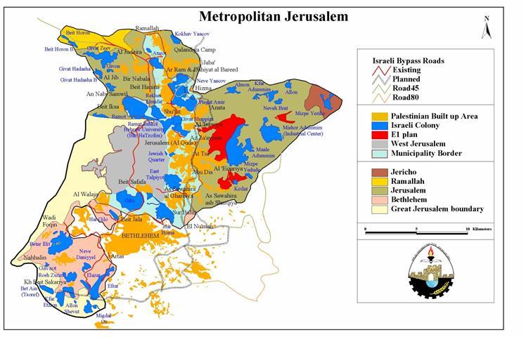
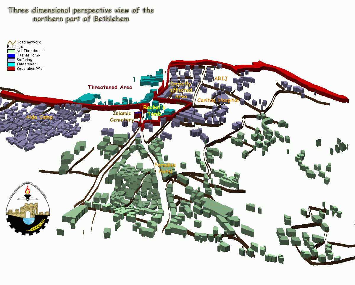
The Israeli government started recently to construct the Separation Wall around Jerusalem, which is 22 Km in length. The wall will physically separate the city of Jerusalem with its two parts, East and west, from the West Bank. The Separation Wall will be an indirect implementation of the Israeli unilateral vision of ''Metropolitan Jerusalem plan''. In addition, the wall will lead to the preemption of the two states vision living side by side with East Jerusalem as the Capital of the future Palestinian State. The Israeli plan of Metropolitan Jerusalem will annex more lands from the West Bank, as the annexation of Rachel's Tomb area that will result in erecting the so-called Envelope of Jerusalem See Map 1.

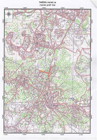
While the drums of war are beating against Iraq, the Israeli occupation forces – IOF- handed the residents on the 16th of February 2003 military orders that are definitely showing the plan to strangulate the city of Bethlehem by confiscating its northern entrance and annexing it to Israel. The plan was discussed in the media in September 11th 2002, where the Israeli security cabinet approved to keep Rachel's Tomb under Israeli control by including the tomb within the Separation zone. The military order number (03/14/T Judea & Samaria 2003) that was distributed shows the blocks and parcels of land seized to be confiscated which are classified in the following table: See Table & Military Order.
Table-1 Parcels of the blocks of land seized at the entrance of Bethlehem City
|
Block n 0 |
parcel n 0 |
Owner |
|
28103 |
20 |
Anton Jeries Anostas/Saleh Elias |
| 68 | Ali Ahmad Shakhtor Mo'ti | |
|
28029 |
19 |
Rougina Handal |
| 32 | Said Murad Al-Siriani | |
| 29 | Waqef Islamique | |
|
28106 |
20 |
Anton Anostas/Shokri Nasser |
| 21 | Maire Hanna Nasser et ses frères | |
| 22 | Victoria Elias Freij | |
| 23 | Sa'dy Barakat | |
| 53 | Monastère Arménien | |
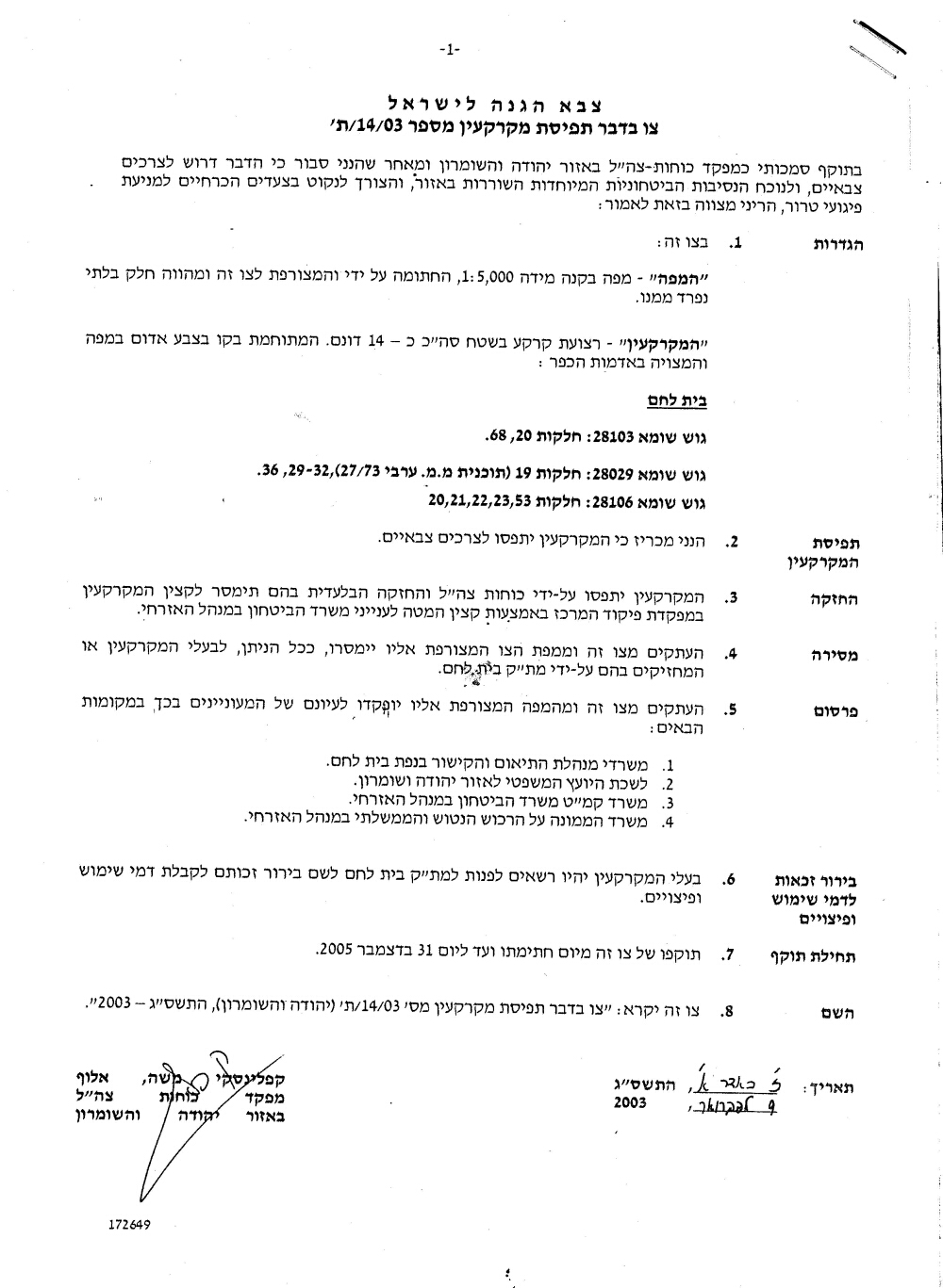
Military order number 03/14/ T Issued by Military Chief Commander Of the IOF in the West Bank: Mosheh Kaplenski
|
Israel Defense Forces Order to Seize lands n0 03/14/T
According to my authorities as a Military Chief Commander in the Region of Judea and Samaria, and as I believe that it is imperative for military reasons due to the special security situation in the region, I order the following: 1. The ''Map'' signed with a scale of 1: 5000 and attached to the order is an essential part of this order. The ''Lands'' : An area of land which is 18 dunums marked in red in the map that exists in Bethlehem:
2. I announce by that the above mentioned lands are seized for military reasons 3. The IDF seize the lands and have an absolute control over it that is given to the officer of the central command officer of lands who is responsible in the ministry of defense. 4. These copies are to be given by the District Co-ordination Office ''The DCO'' of Bethlehem to the owners of land. 5. Copies are found with maps for those who are interested in the following places :
6. The owners of land have the right to go to the DCO in Bethlehem in order to get more information about their right of land use expenses and compensation. 7. The Validity of this order starts at the date signed till 31/12/2005 8. The name of this order is: '' Order to seize lands n0 03/14/T (Judea & Samaria ) 2003 Mosheh Kaplenski
|
Military Order's Translation
According to the Israeli military order, the validity of seizing the land started at the date of signing the order which was the 9th of February 2003 till the 31st of December 2005. However, it is an action of direct confiscation as the IOF has the right to use the land for any purpose. The real aim of this action is to erect the so-called Envelope of Jerusalem which is a part of the Separation wall that Israel is currently constructing in the northern districts of the West Bank and around Jerusalem. The unilateral actions that the Israeli government is applying as a part of its de facto policy contradict directly with the Oslo II. Agreement signed in 1995 as it clearly mentions the following:
''a. Arrangements regarding Rachel's Tomb, which will be considered a special case during the Interim Period:
1. While the Tomb, as well as the main road leading from Jerusalem to the Tomb, as indicated, will be under the security responsibility of Israel, the free movement of Palestinians on the main road will continue.
2. For the purpose of protecting the Tomb, three Israeli guard posts may be located in the Tomb, the roof of the Waqf building, and the parking lot.
b. The present situation and existing practices in the Tomb shall be Preserved''. (Oslo II Agreement, Annex 1, Article V, section 7)
The map handed to the residents by the IOF shows that only 18 dunums are seized and confiscated by the state of Israel, while around 3000 dunums of land will be isolated behind the Wall. The area contains 35 Buildings with a population of 500 people who will be isolated within the future Wall borders. Agricultural lands are already bulldozed and shaved in this area to create trenches with razor wires so as to prevent Palestinians from reaching Jerusalem and many olive trees were uprooted for different Security reasons. See Map 2

Map 2: distributed by The Israeli Occupation Forces in order to seize lands at the northern entrance of Bethlehem District. The red marks shows the lands seized.
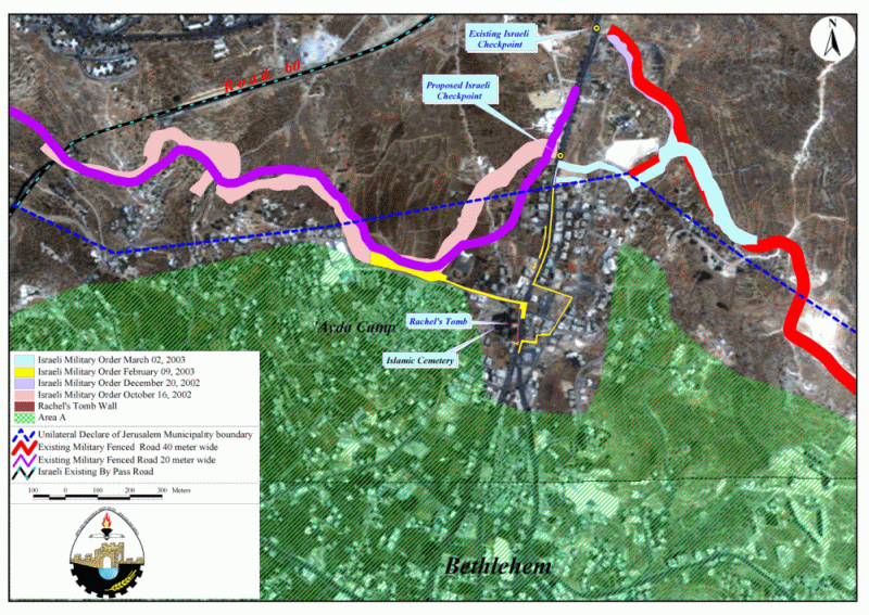
Map 3: Satellite images show the Israeli intentions to construct a part of the Separation Wall at the Northern
entrance of Bethlehem City Annexing by that Rachel's Tomb and the surrounding area.
Map 4: 3 D representation of the future wall in Bethlehem near Rachel's Tomb
Rachel's Tomb was always a part of Bethlehem city, and a pilgrimage place for people of different cultures and religions. Toady the tomb is becoming a military camp and open only for Jews. As planned by the Israeli government it is going to be annexed to Israel. This de facto policy that the Israeli government is applying, costs the Palestinians a lot of their land, homes and heritage that they have conserved throughout history in addition to the damages in Bethlehem tourist industry and the Palestinian economy in general.
This is an urgent appeal from the people of Bethlehem to the world to interfere and stop Israeli actions to strangulate the city of Nativity. This action will result in condensing the people of Bethlehem in ''Ghettos'' and giving them no open space to expand in the future. A genuine intervention by the international community could be done in order to stop Israeli acts of land theft under the pretext of security reasons in Bethlehem and in other districts of the West Bank. See Photo 1 & Photo 2.


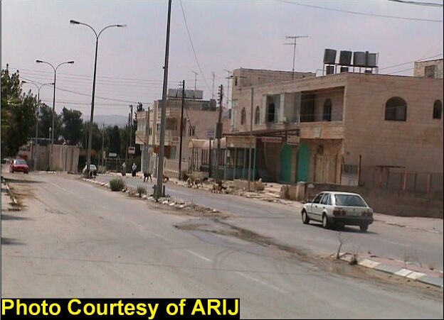
Photo 3: Homes and shops will be Isolated behind the future Wall close to Rachel's Tomb
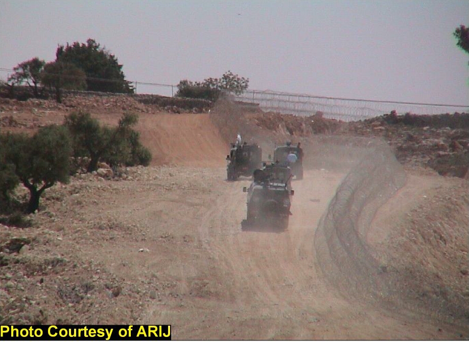
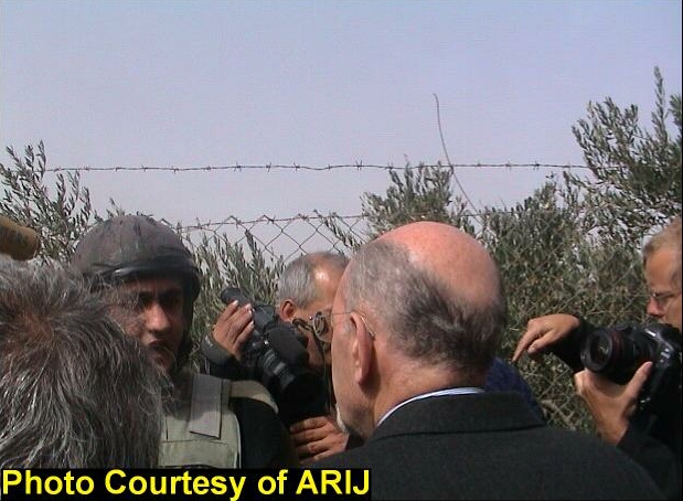
Photo 5: Mayor of Bethlehem Mr. Hanna Nasser, Arguing with the Israeli Military Officer about the
illegitimacy of constructing the Separation Wall at the northern entrance of Bethlehem city.

Photo 6: Dr. Jad Isaac, Director of the Applied Research Institute-Jerusalem (ARIJ)
is explaining to the Media about the proposed plan of the Wall in Bethlehem District.
Prepared by:
The Applied Research Institute – Jerusalem