• About The Project
  • Palestine in Century
  • Selected Maps
  • Glossary
  • About ARIJ
  • About LRC
  • By Year
    • Case Studies By Year
    • Daily Report By Year
Sunday, June 7, 2026
POICA
No Result
View All Result
  • Home
  • Settlements
    • New Israeli Settlements
    • Settlement Expansion
  • Israeli Violations
    • Agriculture
    • Confiscation
    • Demolition
    • Environment
    • Eviction of Palestinians
    • Settlers Attacks
  • Bypass Roads
  • Israeli Plans
  • Segregation
    • Checkpoints
    • Closure
    • Separation Plans
  • Military Orders
  • Reports
    • Daily Report
    • Monthly Report
    • Quarterly Report
No Result
View All Result
POICA
No Result
View All Result

World Silence is an Incentive for new Israeli violations

January 29, 2004
in Military Orders
World Silence is an Incentive for new Israeli violations


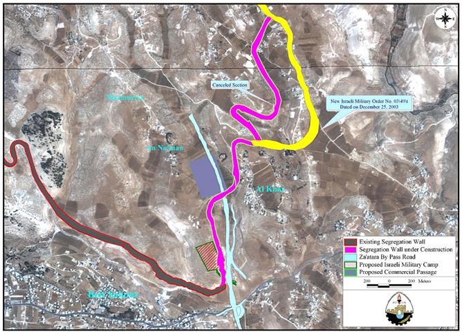
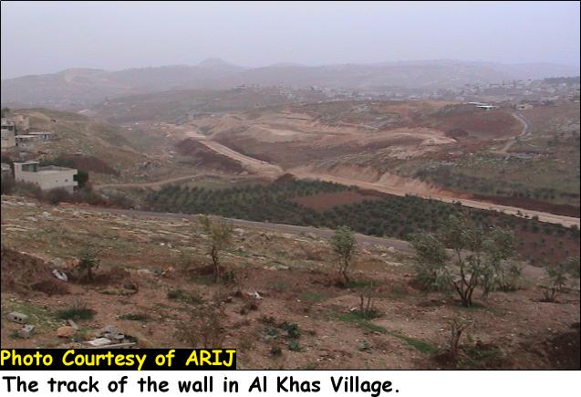
On December 25, 2003, the Israeli Offense Army (IOA) issued a seize order # 03/49T (Judea & Samaria) 2003 ''effective immediately''. The order relocates the route of the Segregation Wall in Al-Khas village east of Beit Sahour in Bethlehem District and in Sur Baher southeast Jerusalem District. See map of military order and Photo 1, Photo 2 & Photo 3


Photo 1, Photo 2 & Photo 3

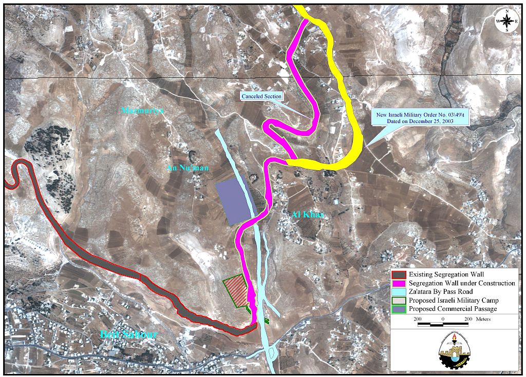
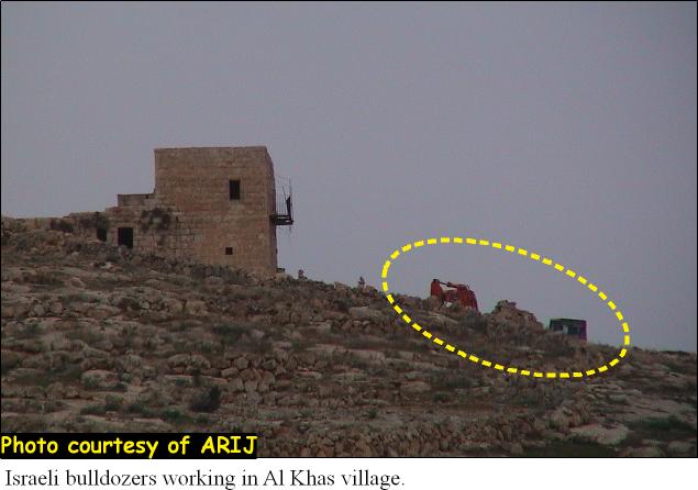
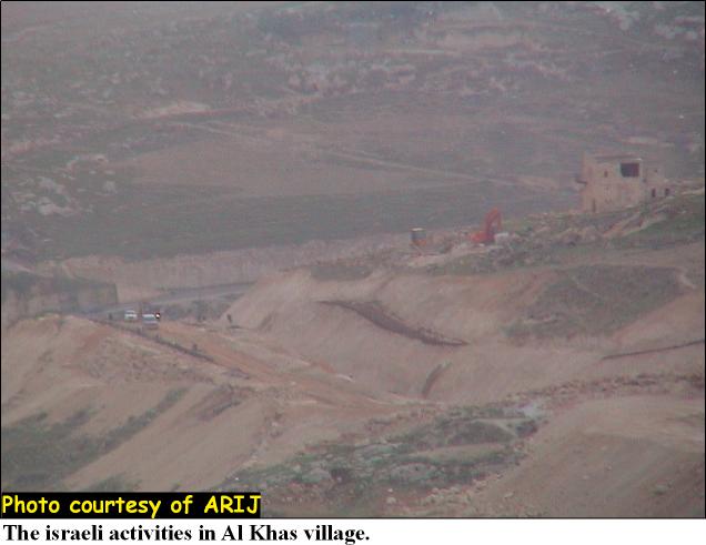
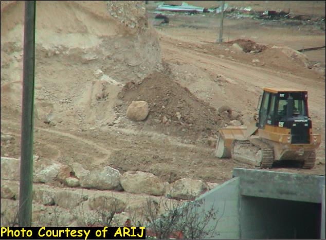
The core of the order validates shifting the route of the Segregation Wall eastward in comparison with the originally approved and declared one. The new shift under the stated order will cost the residents of Al-Khas and Sur Baher an additional 541 Dunums (134 Acers) of which 446 Dunums are agricultural lands while the remaining 95 Dunums are built-up area. The new amendment will include more than 40 Palestinian residences that accommodate more than 200 Palestinians. See Photo 4 & Photo 5..

 c

Photo 4 & Photo 5

Following is a translation of the designated order:

Military Order's Translation

Israel Defense Forces:  Order to Seize lands # 03/49/T (Border Amendment)


According to my authorities as a Military Chief Commander in the Region of Judea and Samaria, and as I believe that it is imperative for military purposes due to the  special security situation in the region, I order the following:


ITEMS


1. With regard to:


The Mapissigned with a scale of 1: 10.000 and attached to the order is an essential part of this order.
The Lands:An area of land that is 122.2 Dunums (length 2054 meter & width ranging 35-90 meter) marked in red in the map that exists within the following villages lands.  


Sur Baher


  • Block 6 – Area: Daher Um Enjim, Soyen Aljinim

  • Block 5- Area: Al-Rock, Bain Adroub


Bethlehem


  • Block 16


Land Seize 


2. I declare by that the above-mentioned lands seized for military purposes.


Land Seize Cancellation


 3. I declare land seized marked yellow in the map are cancelled.


 Possession 


4. The Israeli Defense Army declares absolute possession of stated lands and authorizes it to the land officer at the central command headquarters under the Ministry of Defense.


 Issuance 


5. Copies of the order at hand are to be delivered to the District Coordination Office (DCO) in Bethlehem who will in its turn pass the order on to the landowners. 


Allocation 


6. Copies of the order at hand along with the attached map are to be located at the following places for public reference:


  • District Coordination Offices (DCO) in Bethlehem

  • Offices of the Judicial Advisor for the Region of Judea and Samaria

  •  Office of the Ministry of Defense delegation officer at the civil administration.

  • Office of the Absentee and public lands contact officer at the civil administration.


Land Usage & Compensation Inquiries


7. For inquiries regarding land usage and compensations, the landowners are to contact the District Coordination Office (DCO) in Bethlehem. 


Order Effect


 8. The order will go in effect at the time of its signing to December 31,2005. 


Identify 


9. The order at hand will be identified as ''Land Seize Order # 03/49/T (Judea and Samaria) 2003''.                                   


 Mosheh Kaplenski
         Chief Commander of the Israel Defense Forces in Judea & Samaria
                                         9/2/2003    -Signature


The Israeli seize order is only identifying the new route of the Segregation Wall as the seized lands (122.2 Dunums) while the fact is that the area to be grabbed from the Palestinian territories and to be included within the Wall is 541 Dunums. The targeted area (541 Dunums) is situated between Bethlehem district (390 Dunums-96 Acre) and Jerusalem district (151 Dunums-38 Acre). The targeted land (541 Dunums) is categorized in accordance with the ''Oslo II'' agreement of September 28, 1995 (Areas A, B, and C), which designates varying levels of control. The map below illustrates the areas confiscated as in the table that follows: 

Area in Dunums

District

Total

Dunums

Bethlehem (Al-Khas)

Jerusalem (Sur Baher)

A

156,200

13

169,200

B

24,800

0

24,800

C

209

138

347

Total

390

151

541


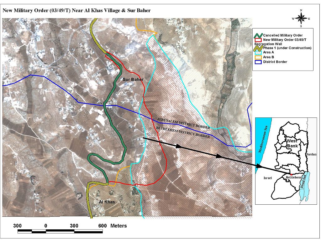
Table 1 show that more than 156 Dunums of Palestinian land are located in Area A, which is under full Palestinian control, it means that Israel is clearly violating the agreements signed with the Palestinians during the peace negotiations. See Photo 6 & Photo 7


Photo 6 & Photo 7


The significance of the order lays in its title (Border Amendment), even though, the Israeli PM Ariel Sharon along with a various government officials repeatedly stated and emphasized that the Wall is not a border. On the other hand, the IOF clearly defines the order of the Segregation Wall as a Border between Israel and the areas under Palestinian jurisdiction. Accordingly, Israel is executing the Segregation Wall with all the amendments it sees fit and constituting consequently a border that guarantee the Israeli vision to annex nearly 60% of the West Bank.  


Prepared by:
The Applied Research Institute – Jerusalem


Recommended For You

سلطات الاحتلال الإسرائيلي بصدد الاستيلاء على موقع قبر النبي صموئيل شمال غرب مدينة القدس

by arij
May 23, 2026
0
سلطات الاحتلال الإسرائيلي بصدد الاستيلاء على موقع قبر النبي صموئيل شمال غرب مدينة القدس

 نشرت سلطات الاحتلال الإسرائيلي في الثامن عشر من شهر أيار من العام 2026 اعلانا مفاده الاستيلاء على الأراضي الفلسطينية في قرية النبي صموئيل شمال غرب القدس المحتلة. وجاء...

Read moreDetails

إقامة منطقة عسكرية عسكرية داخل أراضي (أ) في جنين

by arij
May 19, 2026
0
إقامة منطقة عسكرية عسكرية داخل أراضي (أ) في جنين

   في السابع من شهر أيار من العام 2026، وزعت سلطات الاحتلال الإسرائيلي أمرا عسكريا جديدة على أهالي مدينة جنين يقضي بمصادرة 7.2 دونما من الأراضي الفلسطينية في...

Read moreDetails

“بمساحة اجمالية 177 دونما من أرضي البيرة وبيتين”, طريق استيطاني لخدمة البؤر الاستيطانية في محافظة رام الله

by arij
May 18, 2026
0
“بمساحة اجمالية 177 دونما من أرضي البيرة وبيتين”, طريق استيطاني لخدمة البؤر الاستيطانية في محافظة رام الله

في الحادي عشر من شهر أيار من العام 2026, نشرت دائرة أراضي إسرائيل اعلانا جديدا يقضي بمصادرة المزيد من الأراضي الفلسطينية في محافظة رام الله لأغراض استيطانية في...

Read moreDetails

“في خدمة مستوطنة ناحال حيلتس”, طريق استيطاني إسرائيلي جديد على أراضي بتير وبيت جالا في محافظة بيت لحم

by arij
May 18, 2026
0
“في خدمة مستوطنة ناحال حيلتس”, طريق استيطاني إسرائيلي جديد على أراضي بتير وبيت جالا في محافظة بيت لحم

تواصل سلطات الاحتلال الإسرائيلي إحكام سيطرتها على المزيد من الأراضي الفلسطينية في الضفة الغربية المحتلة، وهذه المرة من خلال استهداف أراضي محافظة بيت لحم. ففي السادس والعشرين من...

Read moreDetails

مناطق نفوذ المستوطنات ودورها في إعادة تشكيل الجغرافيا الفلسطينية

by arij
April 23, 2026
0
مناطق نفوذ المستوطنات ودورها في إعادة تشكيل الجغرافيا الفلسطينية

أصدرت سلطات الاحتلال الإسرائيلي في العاشر من شهر نيسان 2026 الكراسة رقم (273)، وهي وثيقة تضم مجموعة من المناشير والأوامر والتعيينات الإسرائيلية المتعلقة بالجوانب الأمنية والعسكرية والإدارية، إضافة...

Read moreDetails
Next Post
Israeli Security on the Expense of Palestinian human Rights

Israeli Security on the Expense of Palestinian human Rights

LATEST NEWS

سلطات الاحتلال الإسرائيلي بصدد الاستيلاء على موقع قبر النبي صموئيل شمال غرب مدينة القدس

سلطات الاحتلال الإسرائيلي بصدد الاستيلاء على موقع قبر النبي صموئيل شمال غرب مدينة القدس

by arij
May 23, 2026
0

........................................................

إقامة منطقة عسكرية عسكرية داخل أراضي (أ) في جنين

إقامة منطقة عسكرية عسكرية داخل أراضي (أ) في جنين

by arij
May 19, 2026
0

........................................................

الآثار كأداة للضم الزاحف: مشروع القانون الإسرائيلي لإعادة هندسة الجغرافيا والهوية في الضفة الغربية

الآثار كأداة للضم الزاحف: مشروع القانون الإسرائيلي لإعادة هندسة الجغرافيا والهوية في الضفة الغربية

by arij
May 23, 2026
0

........................................................

النكبة الفلسطينية في ذكراها الثامنة والسبعين: من التطهير العرقي إلى الإبادة وإعادة هندسة الجغرافيا الفلسطينية 

النكبة الفلسطينية في ذكراها الثامنة والسبعين: من التطهير العرقي إلى الإبادة وإعادة هندسة الجغرافيا الفلسطينية 

by arij
May 18, 2026
0

........................................................

flag_yellow_lowEU-PfP-Logo

This website and its content were initiated in 1993 by the Applied Research Institute – Jerusalem (ARIJ) and the Land Research Center (LRC) with the support from the European Union up until 2023. Since then, the Applied Research Institute – Jerusalem (ARIJ) has taken over the continued development and maintenance of the website. The views expressed remain solely those of ARIJ) and do not necessarily reflect those of the European Union.

© 2026 Copyright | ARIJ | All Rights reserved.

No Result
View All Result
  • Home
  • Settlements
    • New Israeli Settlements
    • Settlement Expansion
  • Israeli Violations
    • Agriculture
    • Confiscation
    • Demolition
    • Environment
    • Eviction of Palestinians
    • Settlers Attacks
  • Bypass Roads
  • Israeli Plans
  • Segregation
    • Checkpoints
    • Closure
    • Separation Plans
  • Military Orders
  • Reports
    • Daily Report
    • Monthly Report
    • Quarterly Report

© 2026 Copyright | ARIJ | All Rights reserved.