• About The Project
  • Palestine in Century
  • Selected Maps
  • Glossary
  • About ARIJ
  • About LRC
  • By Year
    • Case Studies By Year
    • Daily Report By Year
Tuesday, November 4, 2025
POICA
No Result
View All Result
  • Home
  • Settlements
    • New Israeli Settlements
    • Settlement Expansion
  • Israeli Violations
    • Agriculture
    • Confiscation
    • Demolition
    • Environment
    • Eviction of Palestinians
    • Settlers Attacks
  • Bypass Roads
  • Israeli Plans
  • Segregation
    • Checkpoints
    • Closure
    • Separation Plans
  • Military Orders
  • Reports
    • Daily Report
    • Monthly Report
    • Quarterly Report
No Result
View All Result
POICA
No Result
View All Result

The Annexation of the Jordan Valley… is the loss of a key element of the Palestinian State

July 16, 2022
in Israeli Plans

The land of Mehola settlement was owned by Tubas residents, and was confiscated in 1967 by the Israeli Occupation for the construction of the settelement.


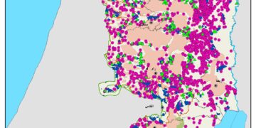
The Jordan Valley is located at the east side of the West Bank territory. It is spread across 841 km square (14.9% of the West Bank total area), starting at the northern tip of the Dead Sea from Jericho and continues northeastern edge of the West Bank at Tubas), accommodating 23 Palestinian communities (population 65+ thousand) and bearing the incursion of 27 Israeli settlements (population 13+ thousand). The Palestinian communities have long withstood the Israeli occupation measures to clear out the Jordan valley since 1967. Israel considers itself as the natural inheritor of all what is identified as “State Land” and most of which overlaps with what Israel categorized as “closed military areas”, “settlement areas”, “military bases”, “nature reserves”, among other classifications, all of which intended to consolidate Israel’s control of that strategic area.

The Israeli occupation notion to annex the Jordan valley area has been on the agenda of all Israeli political parties and of that every Israeli politician, which makes it an issue of concession in the political agenda of Israel.

In fact, when the former president of the United States “Trump” proposed his vision for a solution, he kept the area under Israeli control. Still, no official Israeli party is willing to give up the area under which, any possible future agreement with the Palestinians.

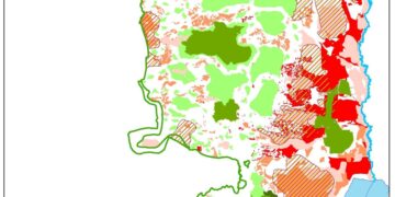
Classifications of the Jordan Valley area 


To fortify its grip over the Jordan Valley,

Israel expanded and fortified its grip over the area when it started to produce plans to increase the settlement’s population, as it certainly wants to double the settler population there. To such end:

  • In 2020, Israel added/ reclassified some 112 km square of the land to the nature reserves category,
  • expansion in 14 settlements with an excess plans to construct 120 housing units,
  • enhance bypass roads to facilitate settler movement:
    • bypass road 90,
    • bypass road 505,
    • bypass road 1
  • possible plans to combine settlements jurisdiction to create larger blocs: (Shadmot Mehola, Rotem, Bitronot, Maskiyot) and (Bqa’ot, Roi, Hemdat)
  • On 18 May 2020, Israeli Authorities advanced plan No.  יוש/ 1633/ 57 to construct an effluent (liquid sewage) treatment facility flowing in Wadi Al Nar “Kidron River”, prior to its transfer through a pipe, to the effluent reservoirs in the Jordan Valley. The proposed reservoir has a capacity of approximately 500,000 cubic meters. 

This will pave the way to increase of infrastructure budgets; including upgrade and construct new bypass roads, increase housing construction and incentive budget to attract more settlers, in addition to commercial and agro-industrial parks.

If anything, Israel seems committed to their intention not to withdraw from the Jordan valley or at least the greater part of it.

However, the economic potential of the Jordan Valley is another factor that makes the Jordan valley an attractive take for the Israeli occupation; but nonetheless an indispensable factor for a future independent-viable Palestinian State.

Under the second Oslo Accord signed between Israel and the Palestinian Liberation organization (PLO) in September 1995 the Jordan valley area was dominantly (91.6%) classified as Area “C” where the Israelis occupation retains absolute control in terms of security and administrative issues related to the land and natural resources. The Palestinian Authority became in control (security and administration) of 7.95% of the remaining area, while just a mere 0.46 were classified as Area “B” where the Palestinian Authority enjoyed only and administrative control of the area.

Jordan Valley classification according to the Second Oslo Accord of 1995

Area Classification

Area in km square

Area in Percentage

Area “A”

67

7.95

Area “B”

3.8

0.46

Area “C”

770.2

91.59

Total

841

100

GIS Department, ARIJ – 2021


Prepared by:  
The Applied Research Institute – Jerusalem 

Recommended For You

الدورة الشتوية للكنيست الإسرائيلي 2025: الضم كسلاح سياسي وإقليمي

by arij
October 25, 2025
0

افتتحت الدورة الشتوية للكنيست الإسرائيلي وسط تصاعد التوترات، وتميزت بهجوم حاد من الحكومة على القضاء. في كلمته الافتتاحية، انتقد رئيس الوزراء بنيامين نتنياهو القضاء مباشرة ودافع عن العمليات...

Read moreDetails

The Israeli Knesset Winter Session 2025: Annexation as a Political and Territorial Weapon

by arij
October 25, 2025
0

Executive Summary The winter session of Israel’s Knesset opened amidst heightened tensions, marked by a sharp government attack on the judiciary. Prime Minister Benjamin Netanyahu, in his opening...

Read moreDetails

منطقة (H2): المساعي الاستيطانية لإسرائيل في تشكيل جغرافيا وديموغرافيا مدينة الخليل التاريخية

by arij
November 3, 2025
0
Israeli Breach of the Hebron Agreement through the Establishment of a New Settlement in Area (H1)

 الوضع الجيوسياسي وديمغرافيا منطقة (H2) في مدينة الخليل  تعد مدينة الخليل واحدة من أقدم المدن الفلسطينية المأهولة وأكثرها أهمية دينية واقتصادية وسياسية في الضفة الغربية، إذ تقع في...

Read moreDetails

الرئاسة الثانية لترامب: فرصة متجددة لطموحات إسرائيل التوسعية – ضم غور الأردن والتداعيات على حل الدولتين واستقرار المنطقة

by arij
October 14, 2025
0
Annexation of the Jordan Valley: Implications for the Two-State Solution and Regional Stability

تجددت مساعي وطموحات إسرائيل لضم غور الأردن، مع فترة الرئاسة الثانية للرئيس الأمريكي دونالد ترامب وبتأييد من ائتلاف رئيس الوزراء بنيامين نتنياهو اليميني المتطرف، والتي أصبحت نقطة تحول...

Read moreDetails

محافظة أريحا على خريطة المصادرة الإسرائيلية- إسرائيل تسعى للاستحواذ على أكثر من 7000 دونم في منطقة النبي موسى

by arij
October 13, 2025
0
محافظة أريحا على خريطة المصادرة الإسرائيلية- إسرائيل تسعى للاستحواذ على أكثر من 7000 دونم في منطقة النبي موسى

في العاشر من شهر أيلول من العام 2025، نشرت ما تُسمّى "بدائرة أراضي إسرائيل" ستة إعلانات جديدة مفادها بأن ما يُعرف بـ*"المسؤول عن أملاك الحكومة"* في الضفة الغربية...

Read moreDetails
Next Post
Halt of Work Order For a Business storage area in Qalqilya City

إخطار بوقف العمل والبناء في منشأة تجارية في مدينة قلقيلية

LATEST NEWS

“ما يزيد عن 25 ألف دونم من أراض الزيتون”,
موسم الزيتون في فلسطين تحت رهن الأوامر العسكرية

by arij
November 3, 2025
0

........................................................

From conflict Resolution to Conflict Management

حول تسجيل الأراضي في مناطق “ج”: سياسة سموتريتش لتمكين السيطرة الإسرائيلية على الأراضي الفلسطينية

by arij
November 3, 2025
0

........................................................

الدورة الشتوية للكنيست الإسرائيلي 2025: الضم كسلاح سياسي وإقليمي

by arij
October 25, 2025
0

........................................................

The Israeli Knesset Winter Session 2025: Annexation as a Political and Territorial Weapon

by arij
October 25, 2025
0

........................................................

flag_yellow_lowEU-PfP-Logo

This website and its content were initiated in 1993 by the Applied Research Institute – Jerusalem (ARIJ) and the Land Research Center (LRC) with the support from the European Union up until 2023. Since then, the Applied Research Institute – Jerusalem (ARIJ) has taken over the continued development and maintenance of the website. The views expressed remain solely those of ARIJ) and do not necessarily reflect those of the European Union.

© 2025 Copyright ARIJ . All Rights reserved. .

No Result
View All Result
  • Home
  • Settlements
    • New Israeli Settlements
    • Settlement Expansion
  • Israeli Violations
    • Agriculture
    • Confiscation
    • Demolition
    • Environment
    • Eviction of Palestinians
    • Settlers Attacks
  • Bypass Roads
  • Israeli Plans
  • Segregation
    • Checkpoints
    • Closure
    • Separation Plans
  • Military Orders
  • Reports
    • Daily Report
    • Monthly Report
    • Quarterly Report

© 2025 Copyright ARIJ . All Rights reserved. .