• About The Project
  • Palestine in Century
  • Selected Maps
  • Glossary
  • About ARIJ
  • About LRC
  • By Year
    • Case Studies By Year
    • Daily Report By Year
Friday, October 3, 2025
POICA
No Result
View All Result
  • Home
  • Settlements
    • New Israeli Settlements
    • Settlement Expansion
  • Israeli Violations
    • Agriculture
    • Confiscation
    • Demolition
    • Environment
    • Eviction of Palestinians
    • Settlers Attacks
  • Bypass Roads
  • Israeli Plans
  • Segregation
    • Checkpoints
    • Closure
    • Separation Plans
  • Military Orders
  • Reports
    • Daily Report
    • Monthly Report
    • Quarterly Report
No Result
View All Result
POICA
No Result
View All Result

Land confiscation orders for the purpose of Wall construction in Hebron governorate

August 23, 2004
in Military Orders
Land confiscation orders for the purpose of Wall construction in Hebron governorate


The Israeli occupation forces distributed three military orders within the past two months stipulating the confiscation of hundreds of dunums in the areas located in the west, north west and south west of Hebron governorate for the purposes of constructing the Segregation Wall.

The numbers of dunums mentioned in the military orders as a target for confiscation, only represent the land where the path of the Wall will be built and do not refer to the land expected to be separated behind the Wall or annexed to Israel. These lands are estimated to be thousands of dunums of Palestinian fertile agricultural lands which serve as the main source of income for thousands of Palestinian villages and peasants who live in that area.

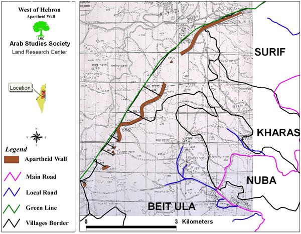
The military orders were signed by the commander of the Israeli army's central command, General Moshe Kaplenski, under the pretext of security and military necessities. The first military order carries the number of T/64/4 concerning the land of the following towns and villages which are all located at the north western part of Hebron governorate:

1.     Surif : in basins number 2 & 3;

2.     Nuba & Kharas: in basins number, 39, 25,18,17,16 & 37;

3.     Beit Ula: in basins number 15, 12 & 7.

The land area which was confiscated in this order is 558.5 dunums (at a length of 5945m and a width of 100 m).  See map of military order as distributed by the Israeli authorities.


The Israeli army map of the Wall attached to the military order No. T/64/4


As mentioned earlier, this area doesn't include the land that will be separated or expropriated behind the Wall which is estimated at thousands of dunums of agricultural lands. The military order gave the affected people only one week to appeal before the Israeli court against this decision. 

The total population of the above mentioned four towns and villages is estimated at 30000 who will be directly or indirectly affected by the construction of the Wall.

In an interview with LRC field worker, Mr. Issa Abu Jarayesh, the head of Kharas municipal council said that about 5000 dunums that belong to villages of Kharas and Nuba will be separated by the Wall. These areas are located between the Green Line and the projected Wall path to the west of the two villages. They are considered amongst the most fertile lands in the area on which many people from both villages depend on their livelihoods. 

The second military order carries the number T/66/4 referring to the lands of the following villages and Hamlets (Khirbets):  Al Burj, Deir Al Asal, Beit ar Rush and As Sikka.  It stipulates the confiscation of 540 dunums (at a length of 5388m and a width of 100m). This area is only for the construction of the Wall path. It doesn't include the lands that will be separated and confiscated behind the wall.  

The total population to be directly or indirectly affected by the construction of the Wall in these four villages and hamlets are about 5000 people.

Earlier in June, 2004, the Israeli military forces issued another military order calling for the confiscation of about 500 dunums from the lands located to the north of the town of Beit Awwa. According to the mayor of Beit Awwa, Mr. Mahmud Masalma, the targeted lands are fertile agricultural plains ideal for the cultivation of cereals and vegetables. 

The distribution of the above mentioned military orders reflects, on one hand, the determination of the current right wing Israeli government to go ahead with plans to build the Wall in these areas to the east of pre- 1967 borders at the expense of West Bank lands. On the other hand, it shows the Israeli government's defiance of the international community represented by the recent International Court of Justice's ruling which called for dismantling the Wall and compensating those affected. See attached map

 The Wall path in Hebron district


Prepared by
The Land Research Center
LRC


Recommended For You

سلطات الاحتلال الإسرائيلي تستغل ‘المنفعة العامة’ لنهب الموارد الفلسطينية

by arij
September 30, 2025
0
سلطات الاحتلال الإسرائيلي تستغل ‘المنفعة العامة’ لنهب الموارد الفلسطينية

في الاول من شهر ايلول من العام 2025، نشرت الإدارة المدنية الإسرائيلية، الذراع الأيمن لحكومة الاحتلال الإسرائيلي أمرا عسكريا جديدا تحت عنوان " أمر ءبشأن قانون الأراضي (الاستملاك...

Read moreDetails

The Occupation Targets the Village of Raba Southeast of Jenin with Military Orders and Seizes Vast Areas of Its Lands

by arij
September 13, 2025
0
الاحتلال يستهدف بأوامر عسكرية قرية رابا جنوب شرق جنين ويصادر مساحات واسعة من أراضيها

 The Israeli occupation Army have continued their policy of plundering Palestinian lands, as their bulldozers leveled wide areas of agricultural land in the village of Raba, southeast of...

Read moreDetails

الاحتلال يستهدف بأوامر عسكرية قرية رابا جنوب شرق جنين ويصادر مساحات واسعة من أراضيها

by arij
September 13, 2025
0
الاحتلال يستهدف بأوامر عسكرية قرية رابا جنوب شرق جنين ويصادر مساحات واسعة من أراضيها

  واصلت قوات الاحتلال الإسرائيلي سياسة نهب الأراضي الفلسطينية، حيث أقدمت آلياتها على تجريف أراض زراعية واسعة في قرية رابا جنوب شرق محافظة جنين، تمهيدا لشق شارع عسكري...

Read moreDetails

Nablus Governorate’s Archaeological Sites Face Israeli Expropriation Plans

by arij
September 11, 2025
0
” المواقع الأثرية في محافظة نابلس… ساحة مفتوحة أمام مخططات المصادرة الإسرائيلية “

On 10 August, 2025, the Israeli Civil Administration (ICA), issued a booklet of military orders signed by the head of the so-called ‘Israeli Civil Administration’ in the occupied...

Read moreDetails

” المواقع الأثرية في محافظة نابلس… ساحة مفتوحة أمام مخططات المصادرة الإسرائيلية “

by arij
August 26, 2025
0
” المواقع الأثرية في محافظة نابلس… ساحة مفتوحة أمام مخططات المصادرة الإسرائيلية “

في العاشر من شهر اب من العام 2025, أصدرت الإدارة المدنية الإسرائيلية كراسة أوامر عسكرية موقعة من قبل رئيس ما يسمى "بالإدارة المدنية الإسرائيلية" في الضفة الغربية المحتلة,...

Read moreDetails
Next Post
Hizma Eclipsed by the Segregation Wall

Hizma Eclipsed by the Segregation Wall

LATEST NEWS

Annexation of the Jordan Valley: Implications for the Two-State Solution and Regional Stability

Annexation of the Jordan Valley: Implications for the Two-State Solution and Regional Stability

by arij
September 29, 2025
0

........................................................

Isolation of Three Villages Northwest of Jerusalem: Silent Annexation Creeps toward the Capital

عزل ثلاث قرى فلسطينية شمال غرب مدينة القدس: الضم الاسرائيلي الصامت يزحف نحو محيط العاصمة

by arij
September 24, 2025
0

........................................................

Isolation of Three Villages Northwest of Jerusalem: Silent Annexation Creeps toward the Capital

Isolation of Three Villages Northwest of Jerusalem: Silent Annexation Creeps toward the Capital

by arij
September 24, 2025
0

........................................................

سياسات التهويد في القدس: من السيطرة المكانية إلى طمس الهوية عبر التسمية

سياسات التهويد في القدس: من السيطرة المكانية إلى طمس الهوية عبر التسمية

by arij
September 23, 2025
0

........................................................

flag_yellow_lowEU-PfP-Logo

This website and its content were initiated in 1993 by the Applied Research Institute – Jerusalem (ARIJ) and the Land Research Center (LRC) with the support from the European Union up until 2023. Since then, the Applied Research Institute – Jerusalem (ARIJ) has taken over the continued development and maintenance of the website. The views expressed remain solely those of ARIJ) and do not necessarily reflect those of the European Union.

© 2025 Copyright ARIJ . All Rights reserved. .

No Result
View All Result
  • Home
  • Settlements
    • New Israeli Settlements
    • Settlement Expansion
  • Israeli Violations
    • Agriculture
    • Confiscation
    • Demolition
    • Environment
    • Eviction of Palestinians
    • Settlers Attacks
  • Bypass Roads
  • Israeli Plans
  • Segregation
    • Checkpoints
    • Closure
    • Separation Plans
  • Military Orders
  • Reports
    • Daily Report
    • Monthly Report
    • Quarterly Report

© 2025 Copyright ARIJ . All Rights reserved. .