• About The Project
  • Palestine in Century
  • Selected Maps
  • Glossary
  • About ARIJ
  • About LRC
  • By Year
    • Case Studies By Year
    • Daily Report By Year
Saturday, June 6, 2026
POICA
No Result
View All Result
  • Home
  • Settlements
    • New Israeli Settlements
    • Settlement Expansion
  • Israeli Violations
    • Agriculture
    • Confiscation
    • Demolition
    • Environment
    • Eviction of Palestinians
    • Settlers Attacks
  • Bypass Roads
  • Israeli Plans
  • Segregation
    • Checkpoints
    • Closure
    • Separation Plans
  • Military Orders
  • Reports
    • Daily Report
    • Monthly Report
    • Quarterly Report
No Result
View All Result
POICA
No Result
View All Result

Jannata Municipality is Targeted Again by a New Israeli Military Orders

September 16, 2006
in Military Orders
Jannata Municipality is Targeted Again by a New Israeli Military Orders

Background

Jannata municipality is an assembly of Palestinian villages/ communities, located south of Bethlehem city, in the southern part of the West Bank.  It is bordered with Hindaza and Bethlehem at the north, Al Ma'sara to the south, Beit Tamir and Za'tara from the east, and Wadi Rahhal to the west.


Jannata municipality constitutes of six small communities: Al 'Asakira, Rakhma, Abu-Njam, Harmallah, AL-Fradees, Betfaluh. In 1996, the Palestinian National Authority allied these communities in one municipality called Jannata for facilitating the provision of services and planning for these communities. The total area of Jannata is 8000 dunums and the built up area constitutes 1760 dunums, distributed among the six communities. The total number of citizens of jannata assembly is more than 4550 people, (PCBS 2006)


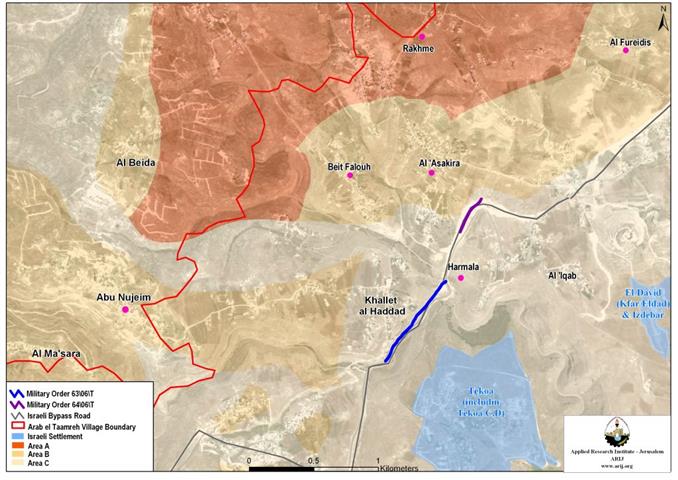
The Oslo II Agreement, signed in 1995 classified the West Bank territory into three different control areas; A, B and C and Jannata villages/ communities were accordingly classified. Rakhma village lands is classified as Area “A”, which falls completely under full Palestinian control; Al-Asakira (partially), Betfaluh, Abu-Njam and Fradees are classified as area B, where the Palestinian Authority has full control over the civil administration and Israel continues to have overriding responsibility for security; as for Harmallah and parts of Al Asakira, the lands there are classified as area C, where Israel retains full control. See map 1


The Infringement

On August 28, 2006, the Israeli Occupation Forces (IOF) notified Jannata municipality through military orders holding numbers: (06/63/T) & (06/64/T) of the Army’s decision to confiscate 3 dunums and 900 meters from Harmallah village lands owned by Subeih and Al Zeer families, and 1.4 Dunums from Al Asakira village lands owned by Al Kamel family under the pretext of security necessities. According to the military orders, the purpose from the confiscations is installing a security fence on both sides of Za3tara bypass road under the pretext of “Road Protection'.


The consequences of the Israeli military orders in Jannata will limit the Palestinian communities' expansion and more than that isolate the residents of these communities from reaching their agricultural and grazing lands. Furthermore, social, educational and health services will be affected as roads amongst the communities will be cut of or rerouted at best scenarios to triple the distination needed to get from one place to the other once the security fence along side bypass road is installed.


To Conclude:

The Israeli Plan in Jannata contradicts with the basic right granted to all persons to move about freely and without restrictions. Under international law; Israel is  breaching Jannata’s residents right to freedom of movement and this explicitly expressed in 'Article 12' of the International Covenant on Civil and Political Rights and 'Article 13' of the Universal Declaration of Human Rights, which reads:


Article 12:


Everyone lawfully within the territory of a State shall, within that territory, have the right to liberty of movement and freedom to choose his residence.


International Covenant on Civil and Political Rights/ entry into force 23 March 1976, in accordance with Article 49


Article 13:


Everyone has the right to freedom of movement and residence within the borders of each State.The Universal Declaration of Human Rights


Also under the Universal Declaration of Human Rights adopted and proclaimed by General Assembly resolution 217 A (III) of, December 10, 1948, Article 17 reads: 'No one shall be arbitrarily deprived of his property.' Which means it bans Israel from destroying or confiscating the property of the Palestinians at any case.


The Hague Regulationsexpressly forbids an occupying power 'to destroy or seize the enemy's property, unless such destruction or seizure is imperatively demanded by the necessities of war' (Article 23). 


Obviously and on the ground Israel is manipulating the 'security' pretext to facilitate the realization of the Israeli State objective, which is to capture as much possible lands from the West Bank territory and Gaza Strip.


Prepared by
The Applied Research Institute – Jerusalem
ARIJ

Recommended For You

سلطات الاحتلال الإسرائيلي بصدد الاستيلاء على موقع قبر النبي صموئيل شمال غرب مدينة القدس

by arij
May 23, 2026
0
سلطات الاحتلال الإسرائيلي بصدد الاستيلاء على موقع قبر النبي صموئيل شمال غرب مدينة القدس

 نشرت سلطات الاحتلال الإسرائيلي في الثامن عشر من شهر أيار من العام 2026 اعلانا مفاده الاستيلاء على الأراضي الفلسطينية في قرية النبي صموئيل شمال غرب القدس المحتلة. وجاء...

Read moreDetails

إقامة منطقة عسكرية عسكرية داخل أراضي (أ) في جنين

by arij
May 19, 2026
0
إقامة منطقة عسكرية عسكرية داخل أراضي (أ) في جنين

   في السابع من شهر أيار من العام 2026، وزعت سلطات الاحتلال الإسرائيلي أمرا عسكريا جديدة على أهالي مدينة جنين يقضي بمصادرة 7.2 دونما من الأراضي الفلسطينية في...

Read moreDetails

“بمساحة اجمالية 177 دونما من أرضي البيرة وبيتين”, طريق استيطاني لخدمة البؤر الاستيطانية في محافظة رام الله

by arij
May 18, 2026
0
“بمساحة اجمالية 177 دونما من أرضي البيرة وبيتين”, طريق استيطاني لخدمة البؤر الاستيطانية في محافظة رام الله

في الحادي عشر من شهر أيار من العام 2026, نشرت دائرة أراضي إسرائيل اعلانا جديدا يقضي بمصادرة المزيد من الأراضي الفلسطينية في محافظة رام الله لأغراض استيطانية في...

Read moreDetails

“في خدمة مستوطنة ناحال حيلتس”, طريق استيطاني إسرائيلي جديد على أراضي بتير وبيت جالا في محافظة بيت لحم

by arij
May 18, 2026
0
“في خدمة مستوطنة ناحال حيلتس”, طريق استيطاني إسرائيلي جديد على أراضي بتير وبيت جالا في محافظة بيت لحم

تواصل سلطات الاحتلال الإسرائيلي إحكام سيطرتها على المزيد من الأراضي الفلسطينية في الضفة الغربية المحتلة، وهذه المرة من خلال استهداف أراضي محافظة بيت لحم. ففي السادس والعشرين من...

Read moreDetails

مناطق نفوذ المستوطنات ودورها في إعادة تشكيل الجغرافيا الفلسطينية

by arij
April 23, 2026
0
مناطق نفوذ المستوطنات ودورها في إعادة تشكيل الجغرافيا الفلسطينية

أصدرت سلطات الاحتلال الإسرائيلي في العاشر من شهر نيسان 2026 الكراسة رقم (273)، وهي وثيقة تضم مجموعة من المناشير والأوامر والتعيينات الإسرائيلية المتعلقة بالجوانب الأمنية والعسكرية والإدارية، إضافة...

Read moreDetails
Next Post
Israel and the Methodic House Destruction Policy in the West Bank and Gaza Strip

Israel and the Methodic House Destruction Policy in the West Bank and Gaza Strip

LATEST NEWS

سلطات الاحتلال الإسرائيلي بصدد الاستيلاء على موقع قبر النبي صموئيل شمال غرب مدينة القدس

سلطات الاحتلال الإسرائيلي بصدد الاستيلاء على موقع قبر النبي صموئيل شمال غرب مدينة القدس

by arij
May 23, 2026
0

........................................................

إقامة منطقة عسكرية عسكرية داخل أراضي (أ) في جنين

إقامة منطقة عسكرية عسكرية داخل أراضي (أ) في جنين

by arij
May 19, 2026
0

........................................................

الآثار كأداة للضم الزاحف: مشروع القانون الإسرائيلي لإعادة هندسة الجغرافيا والهوية في الضفة الغربية

الآثار كأداة للضم الزاحف: مشروع القانون الإسرائيلي لإعادة هندسة الجغرافيا والهوية في الضفة الغربية

by arij
May 23, 2026
0

........................................................

النكبة الفلسطينية في ذكراها الثامنة والسبعين: من التطهير العرقي إلى الإبادة وإعادة هندسة الجغرافيا الفلسطينية 

النكبة الفلسطينية في ذكراها الثامنة والسبعين: من التطهير العرقي إلى الإبادة وإعادة هندسة الجغرافيا الفلسطينية 

by arij
May 18, 2026
0

........................................................

flag_yellow_lowEU-PfP-Logo

This website and its content were initiated in 1993 by the Applied Research Institute – Jerusalem (ARIJ) and the Land Research Center (LRC) with the support from the European Union up until 2023. Since then, the Applied Research Institute – Jerusalem (ARIJ) has taken over the continued development and maintenance of the website. The views expressed remain solely those of ARIJ) and do not necessarily reflect those of the European Union.

© 2026 Copyright | ARIJ | All Rights reserved.

No Result
View All Result
  • Home
  • Settlements
    • New Israeli Settlements
    • Settlement Expansion
  • Israeli Violations
    • Agriculture
    • Confiscation
    • Demolition
    • Environment
    • Eviction of Palestinians
    • Settlers Attacks
  • Bypass Roads
  • Israeli Plans
  • Segregation
    • Checkpoints
    • Closure
    • Separation Plans
  • Military Orders
  • Reports
    • Daily Report
    • Monthly Report
    • Quarterly Report

© 2026 Copyright | ARIJ | All Rights reserved.