• About The Project
  • Palestine in Century
  • Selected Maps
  • Glossary
  • About ARIJ
  • About LRC
  • By Year
    • Case Studies By Year
    • Daily Report By Year
Sunday, June 7, 2026
POICA
No Result
View All Result
  • Home
  • Settlements
    • New Israeli Settlements
    • Settlement Expansion
  • Israeli Violations
    • Agriculture
    • Confiscation
    • Demolition
    • Environment
    • Eviction of Palestinians
    • Settlers Attacks
  • Bypass Roads
  • Israeli Plans
  • Segregation
    • Checkpoints
    • Closure
    • Separation Plans
  • Military Orders
  • Reports
    • Daily Report
    • Monthly Report
    • Quarterly Report
No Result
View All Result
POICA
No Result
View All Result

Israeli revised Wall path cuts linkage between Kafr Laqif, Azzun Ashamalia villages and Nablus city

February 8, 2007
in Military Orders
Israeli revised Wall path cuts linkage between Kafr Laqif,  Azzun Ashamalia villages and Nablus city

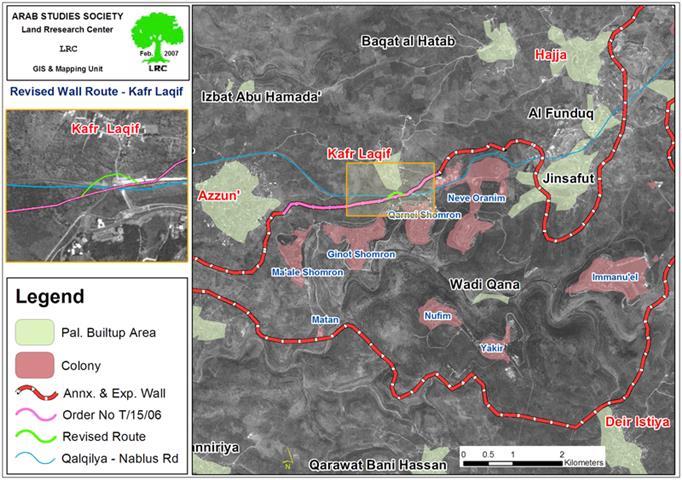
The Israeli occupation army issued an a amendment for the military order number T/15/06  stating the confiscation of an additional 24 dunums and 400 M2 for the purpose of revising the path of the Segregation Wall in the lands of Azzun Ashamaliay and Kafr Laqif, Qalqiliya governorate. The new amendment which was issued at the beginning of last January aims at cutting off the roads that link between Kafr Laqif and Azzun Ashamaliay villages and the main Qalqiliya – Nablus road (road No. 55) which will be annexed to Ma'ale Shomron colonial block and will be exclusively used by Israeli settlers living in this area. The Ma'ale Shomron block is, also, part of the biggest finger â��like corridor in the West Bank â�� Ariel corridor. See Map


Map prepared by LRC


The initial plan Wall plan in this section was announced in February, 2006  stating the confiscation of 279 dunums from the lands of Hajja, Kafr Laqif, and Azzun Ashamaliay, Qalqiliay governorate and Deir Istiya village in Salfit governorate.


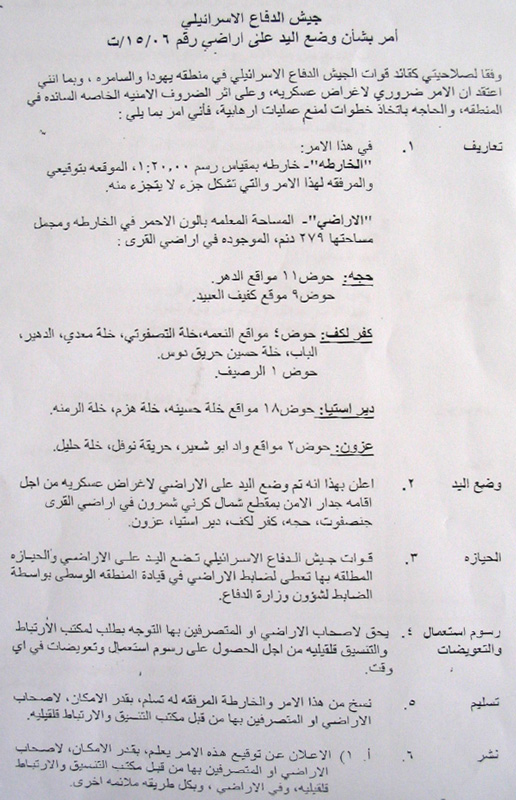
(Military photos No. 2 & 3: Copies of original military order No. T/15/06 and the attached map )


The planned route in this section is about 3000 meters long and between 80 to 100 meters wide. The above number doesnâ��t include the land that will be separated behind the Wall which is estimated at thousands of dunums.  


The Wall route is planned to pass through the lands of these four Palestinian villages so as to complete the bordering of the biggest finger-like corridor in the West Bank which aims at ensuring the annexation into Israel of all Israeli colonies in the area. This finger- like corridor of Ariel settlement block includes15 colonies: Ariel, Yakir, Revava, Qiriyat Netafim, Neve Oranim, Carnei Shomron, Ginnot Shomron, Ma'ale Shomron, Immanuel, Nufim,  Barqan, Alei Zahav ( Yo'ezer), Pedu'el, Beit Arie and Ofarim.


Since the commencement  of the Wall works in this section last year, more than 2000 fruitful olive trees have been destroyed or uprooted as well as destroying 20 dunums of land used for seasonal ground crops. About 70 Palestinian family from the four above mentioned villages own the land that has been destroyed under or separated behind the  Wall path.


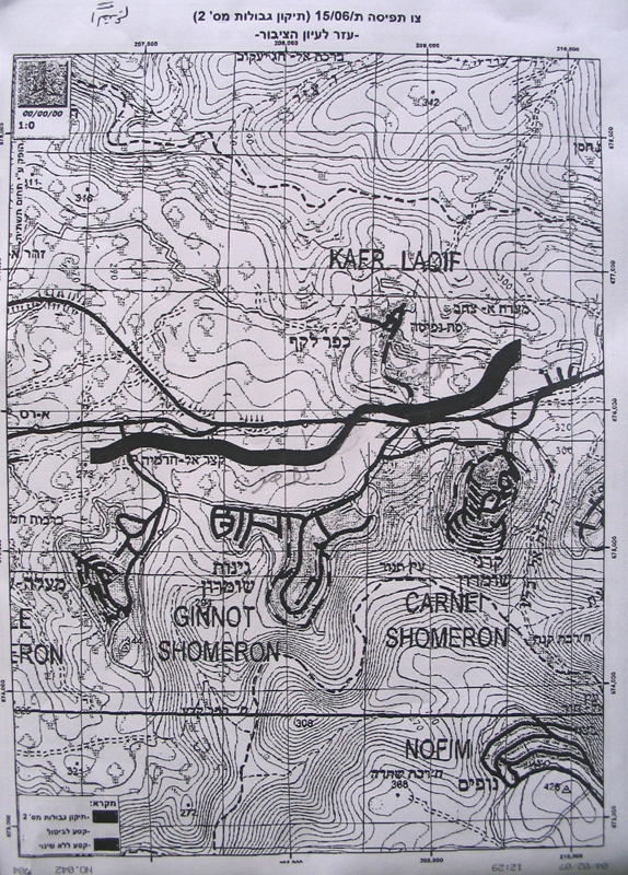
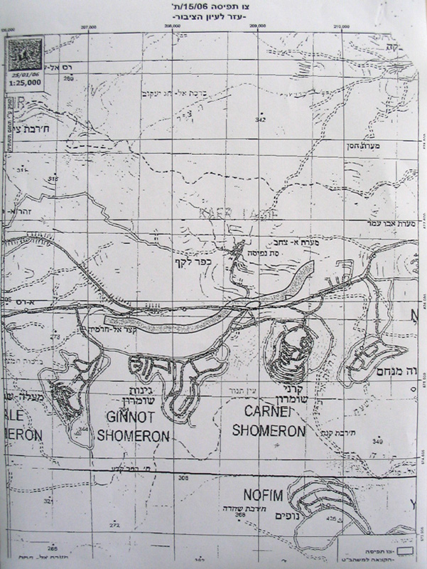
(Photos 4 & 5 : copies of the revised military order No. T/15/06 and the attached map)


Location, population and area


The following table provides information on the four Palestinian villages by Location, population and area:


No

Village name

Location

Population

Area in dunum


Total

Built up

1

Hajja

Qalqiliya

2000

11717

932

2

Kafr Laqif

Qalqiliya

750

2579

298

3

Azzun

Qalqiliya

6500

9140

1525

4

Deir Istia

Salfit

3500

34000

900

Total

12750

57436

3655


The Ariel finger like corridor will result in the annexation of thousands of dunums of Palestinian lands and dozens of underground water wells which, in effect, will cause disastrous impact on the very existence and welfare of Palestinian people in the area.  From Azzun Ashamaliay alone, more than 1600 dunum of agricultural lands has been separated behind the Wall and are feared to be used for future colonial expansion of Ariel corridor. 


Work in this biggest finger-like corridor in the West Bank started at the beginning of the year 2003 under a call by the former Israeli premier Ariel Sharon.


Impacts on Palestinians


1.     Bulldozing thousands of dunums of olive orchards considered to be the only source of living for Palestinian families, particularly, after loosing jobs inside Israel;


2.     The difficulty of accessing into agricultural lands which have been already separated behind the Wall;


3.     Giving Israeli settlers in the area a wide scale space of land for expansion and development at the expense of Palestinian land and future development.


4.     The above mentioned amendment will cut the main Qalqiliay-Nablus road forcing the citizens of Kafr Laqif, for instance, to travel 46 km instead of the ordinary 20 km long route to reach the city of Nablus.   


5.     The heirs of Late Mr. Rushdi Othman Shubaita, from Azzun, are mostly affected by the construction of the Wall in the eastern side of the village as they had lost about 44 dunums under its path, in addition to the destruction of at least 380 olive trees. Similarly, the heirs of Late Mr. Rashid Abdul Jawwad had lost about 21 dunums and more than 210 olive trees in the same location.


Legal action


Last march, the municipalities of Azzun and Kafr Laqif, along with the affected farmers and land owners had presented an objection to the Israeli legal advisor at Beit Eil ' civil Administration' against the aforementioned military order and its planned route. No response has been received yet.  


Prepared by
The Land Research Center
LRC


Recommended For You

سلطات الاحتلال الإسرائيلي بصدد الاستيلاء على موقع قبر النبي صموئيل شمال غرب مدينة القدس

by arij
May 23, 2026
0
سلطات الاحتلال الإسرائيلي بصدد الاستيلاء على موقع قبر النبي صموئيل شمال غرب مدينة القدس

 نشرت سلطات الاحتلال الإسرائيلي في الثامن عشر من شهر أيار من العام 2026 اعلانا مفاده الاستيلاء على الأراضي الفلسطينية في قرية النبي صموئيل شمال غرب القدس المحتلة. وجاء...

Read moreDetails

إقامة منطقة عسكرية عسكرية داخل أراضي (أ) في جنين

by arij
May 19, 2026
0
إقامة منطقة عسكرية عسكرية داخل أراضي (أ) في جنين

   في السابع من شهر أيار من العام 2026، وزعت سلطات الاحتلال الإسرائيلي أمرا عسكريا جديدة على أهالي مدينة جنين يقضي بمصادرة 7.2 دونما من الأراضي الفلسطينية في...

Read moreDetails

“بمساحة اجمالية 177 دونما من أرضي البيرة وبيتين”, طريق استيطاني لخدمة البؤر الاستيطانية في محافظة رام الله

by arij
May 18, 2026
0
“بمساحة اجمالية 177 دونما من أرضي البيرة وبيتين”, طريق استيطاني لخدمة البؤر الاستيطانية في محافظة رام الله

في الحادي عشر من شهر أيار من العام 2026, نشرت دائرة أراضي إسرائيل اعلانا جديدا يقضي بمصادرة المزيد من الأراضي الفلسطينية في محافظة رام الله لأغراض استيطانية في...

Read moreDetails

“في خدمة مستوطنة ناحال حيلتس”, طريق استيطاني إسرائيلي جديد على أراضي بتير وبيت جالا في محافظة بيت لحم

by arij
May 18, 2026
0
“في خدمة مستوطنة ناحال حيلتس”, طريق استيطاني إسرائيلي جديد على أراضي بتير وبيت جالا في محافظة بيت لحم

تواصل سلطات الاحتلال الإسرائيلي إحكام سيطرتها على المزيد من الأراضي الفلسطينية في الضفة الغربية المحتلة، وهذه المرة من خلال استهداف أراضي محافظة بيت لحم. ففي السادس والعشرين من...

Read moreDetails

مناطق نفوذ المستوطنات ودورها في إعادة تشكيل الجغرافيا الفلسطينية

by arij
April 23, 2026
0
مناطق نفوذ المستوطنات ودورها في إعادة تشكيل الجغرافيا الفلسطينية

أصدرت سلطات الاحتلال الإسرائيلي في العاشر من شهر نيسان 2026 الكراسة رقم (273)، وهي وثيقة تضم مجموعة من المناشير والأوامر والتعيينات الإسرائيلية المتعلقة بالجوانب الأمنية والعسكرية والإدارية، إضافة...

Read moreDetails
Next Post
Israeli commences the construction of the Segregation Wall north of Beit Jala City

Israeli commences the construction of the Segregation Wall north of Beit Jala City

LATEST NEWS

سلطات الاحتلال الإسرائيلي بصدد الاستيلاء على موقع قبر النبي صموئيل شمال غرب مدينة القدس

سلطات الاحتلال الإسرائيلي بصدد الاستيلاء على موقع قبر النبي صموئيل شمال غرب مدينة القدس

by arij
May 23, 2026
0

........................................................

إقامة منطقة عسكرية عسكرية داخل أراضي (أ) في جنين

إقامة منطقة عسكرية عسكرية داخل أراضي (أ) في جنين

by arij
May 19, 2026
0

........................................................

الآثار كأداة للضم الزاحف: مشروع القانون الإسرائيلي لإعادة هندسة الجغرافيا والهوية في الضفة الغربية

الآثار كأداة للضم الزاحف: مشروع القانون الإسرائيلي لإعادة هندسة الجغرافيا والهوية في الضفة الغربية

by arij
May 23, 2026
0

........................................................

النكبة الفلسطينية في ذكراها الثامنة والسبعين: من التطهير العرقي إلى الإبادة وإعادة هندسة الجغرافيا الفلسطينية 

النكبة الفلسطينية في ذكراها الثامنة والسبعين: من التطهير العرقي إلى الإبادة وإعادة هندسة الجغرافيا الفلسطينية 

by arij
May 18, 2026
0

........................................................

flag_yellow_lowEU-PfP-Logo

This website and its content were initiated in 1993 by the Applied Research Institute – Jerusalem (ARIJ) and the Land Research Center (LRC) with the support from the European Union up until 2023. Since then, the Applied Research Institute – Jerusalem (ARIJ) has taken over the continued development and maintenance of the website. The views expressed remain solely those of ARIJ) and do not necessarily reflect those of the European Union.

© 2026 Copyright | ARIJ | All Rights reserved.

No Result
View All Result
  • Home
  • Settlements
    • New Israeli Settlements
    • Settlement Expansion
  • Israeli Violations
    • Agriculture
    • Confiscation
    • Demolition
    • Environment
    • Eviction of Palestinians
    • Settlers Attacks
  • Bypass Roads
  • Israeli Plans
  • Segregation
    • Checkpoints
    • Closure
    • Separation Plans
  • Military Orders
  • Reports
    • Daily Report
    • Monthly Report
    • Quarterly Report

© 2026 Copyright | ARIJ | All Rights reserved.