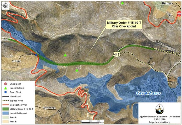
On the 15th of March, 2010, the Chief Commander of the Israeli Occupation Forces in Judea & Samaria, Avi Mezrachi, issued two new military orders numbered (T/14/10) & (T/15/10) for the purpose of confiscating 173 dunums of Palestinian owned lands in Betunia and At Tira communities south and southwest of Ramallah city. The first order (15/10/T) states the confiscation of 124.2 dunums of lands of Betunia and At Tira communities to build a security fence along the Israeli bypass road 443 to provide protection to Israeli settlers driving on this road before lifting off the travel ban on Palestinians. The confiscated lands are adjacent to bypass road 443 that was closed off to Palestinian travelers following the eruption of the second Palestinian intifada in 2000 as to prevent Palestinians’ attacks against Israeli settlers driving on this road, Israeli officials claimed. ) for the purpose of confiscating 173 dunums of Palestinian owned lands in Betunia and At Tira communities south and southwest of Ramallah city. The first order () states the confiscation of 124.2 dunums of lands of Betunia and At Tira communities to build a security fence along the Israeli bypass road 443 to provide protection to Israeli settlers driving on this road before lifting off the travel ban on Palestinians. The confiscated lands are adjacent to bypass road 443 that was closed off to Palestinian travelers following the eruption of the second Palestinian intifada in 2000 as to prevent Palestinians’ attacks against Israeli settlers driving on this road, Israeli officials claimed. ) for the purpose of confiscating 173 dunums of Palestinian owned lands in Betunia and At Tira communities south and southwest of Ramallah city. The first order () states the confiscation of 124.2 dunums of lands of Betunia and At Tira communities to build a security fence along the Israeli bypass road 443 to provide protection to Israeli settlers driving on this road before lifting off the travel ban on Palestinians. The confiscated lands are adjacent to bypass road 443 that was closed off to Palestinian travelers following the eruption of the second Palestinian intifada in 2000 as to prevent Palestinians’ attacks against Israeli settlers driving on this road, Israeli officials claimed. ) & () for the purpose of confiscating 173 dunums of Palestinian owned lands in Betunia and At Tira communities south and southwest of Ramallah city. The first order () states the confiscation of 124.2 dunums of lands of Betunia and At Tira communities to build a security fence along the Israeli bypass road 443 to provide protection to Israeli settlers driving on this road before lifting off the travel ban on Palestinians. The confiscated lands are adjacent to bypass road 443 that was closed off to Palestinian travelers following the eruption of the second Palestinian intifada in 2000 as to prevent Palestinians’ attacks against Israeli settlers driving on this road, Israeli officials claimed.
The second Israeli military order holds number (14/10/T) and states the confiscation of 49.02 dunums of lands of Betunia Town for the establishment of Ofer Crossing. See Table 1 ) and states the confiscation of 49.02 dunums of lands of Betunia Town for the establishment of Ofer Crossing. See Table 1
|
Table 1:- Details of the Israeli Military Orders number (14/10/T) & (15/10/T)
|
||||
|
|
Military Order No.
|
Total Confiscated Area (Dunums)
|
Village boundary
|
Purpose of confiscation
|
|
1.
|
49.02
|
Betunia
|
Offra Checkpoint
|
|
|
2.
|
124.2
|
Al Tireh
|
Side route security wall
|
|
|
Total
|
173.22 dunums
|
|||
|
*1 square Kilometers = 1000 Dunums
|
||||
|
Source: The Geo-Information System – ARIJ, 2010
|
||||
An Analysis conducted by the Geographical Information system unit at the Applied Research Institute – Jerusalem (ARIJ) to the maps that were provide with the military order showed that the Israeli military order number (T/15/10) confiscates an actual space of land summed up to 248 dunums for the construction of the security fence rather than 124.2 dunums that were stated in the military Order. ) confiscates an actual space of land summed up to 248 dunums for the construction of the security fence rather than 124.2 dunums that were stated in the military Order.


Photo 1 & Map 1 : A copy of the Israeli military order number (T/15/10)
ARIJ’s translation to the Military Order number (T/15/10)
Lifting the ban on Palestinian Travel
On December 19, 2010, the Israeli Supreme Court issued an order requesting the Israeli Occupation army to lift the ban imposed on Palestinians traveling on bypass road number 443. The court ruling described the ban as ‘unauthorized and disproportional’The Court also gave the Israeli Occupation army a period of five months to find a solution on how to provide security and protection to Israeli settlers driving on the road, while at the same time, to allow Palestinians to use the road.
It is clear that Palestinians of Betunia and At Tira communities will pay the price of the security arrangements that will be taken by the Israeli Occupation army, which is not new to residents of the two communities as when Israel started constructing the bypass road 443 in the late seventies, it confiscated large tracts of land for this purpose. In the late eighties, Israel again confiscated large tracts of Betunia lands for the purpose of expanding the road. Betunia residents filed objections to the court against the confiscation of their lands but the objections were declined under the pretext that expansion works being carrid out on this road will also serve Palestinian communities.
Later, when the second Intifada erupted in September 2000, Israeli Occupation Army closed the Israeli Bypass road 443 in the face of Palestinian travelers. The closure of this road has increased the burden on Palestinians as they were forced to seek alternatives to travel between Palestinian villages and to the city of Ramallah and the elsewhere in the West Bank.
Creating a Network of Alternative Roads for Palestinians
The Israeli bypass road no. 443 links between the city of Ramallah and several Palestinian villages to the south-west of the city, such as Saffa, Beit Sira, Kharbatha Al MIsbah, Beit Ur al-Tahta, Beit Ur al Fawqa, At Tira, and Beitunia. Following the closure of the road in 2002, the Israeli Occupation army confiscated more Palestinian lands from Betunia town to construct an alternative road for Palestinians who used to drive on bypass road 443. The road did not meet the minimal needed specifications of Palestinians of the aforementioned villages. Driving on this alternative road (to Ramallah city) takes Palestinians from 45 minutes to one hour time, while it used to take them around 10 minutes to drive on bypass road 443 to reach the same destination. This alternative road is part of an Israeli scheme to create two networks of roads, one Israeli and one Palestinian. However, the Israeli network is a continuous road network that links together all Israeli settlements located in the Palestinian Territories, while the Palestinian network is fractured and unsustainable. This in turn, will result in segregating the Palestinian communities into Ghettos with only limited access through the proposed 18 tunnels.
Freedom of movement is the ‘Price Tag’
A crossing to control the movement of Palestinians after lifting the travel ban
The Israeli daily newspaper, Haaretz, reported in its edition published on the 22ed of January, 2010, that a crossing is planned to replace the Ofer checkpoint located west of Ofer Military Camp (at Betunia Junction). The map that was provided with the Israeli military order number 14/10/T came to bolster what published in Haaretz. The map showed that a crossing is set to be constructed at Giv’at Ze’ev Settlement junction to replace the Ofer checkpoint. This crossing will control the movement of Palestinians on bypass road no. 443 after lifting the tavel ban on them. See Map provide with the military Order.
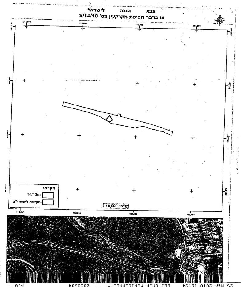
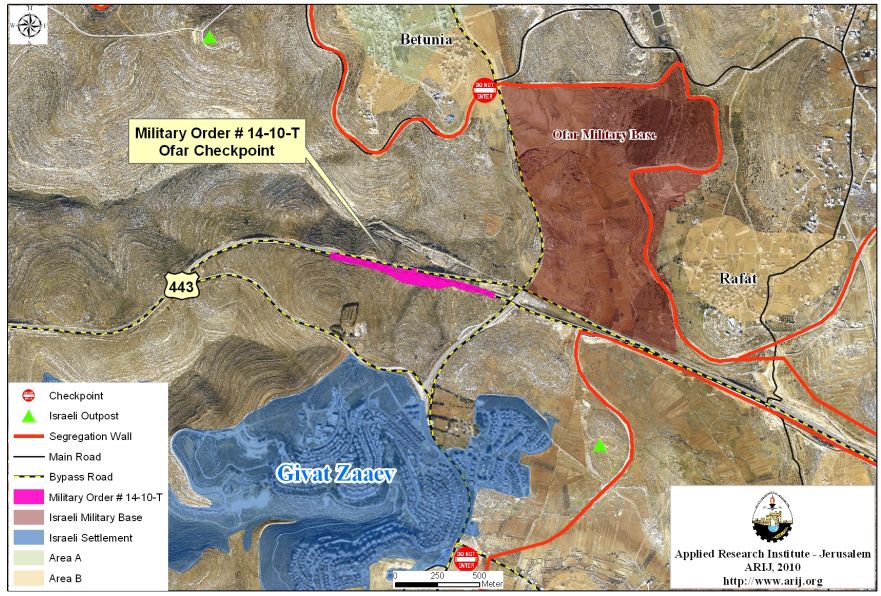
Photo 2 & Map 2 : A copy of the Israeli military order number (T/14/10)
ARIJ’s translation to the Military Order number (T/14/10)
To Conclude:
The confiscation and destruction of Palestinian land is clear violation of the Fourth Geneva Convention, Article 147 which clearly prohibits extensive destruction and appropriation of property, not justified by military necessity and carried out unlawfully and wantonly; and Article 49 of the Fourth Geneva Convention also states that: ‘ Individual or mass forcible transfers, as well as deportations of protected persons from occupied territory to the territory of the Occupying Power or to that of any other country, occupied or not, are prohibited, regardless of their motive.‘ Violations of Articles of the Fourth Geneva Convention constitute breaches of the Convention and should be prosecuted as War Crimes.
Also Israel continues to violate its obligations as an occupying power under international law rules. The Israeli practices in the Palestinian territory clearly contradict with:
-
The International Covenant on Economic, Social and Cultural Rights (ICESCR) – Food (ICESCR, art. 11): The States Parties to the present Covenant recognize the right of everyone to an adequate standard of living for himself and his family, including adequate food, clothing and housing, and to the continuous improvement of living conditions. The States Parties will take appropriate steps to ensure the realization of this right, recognizing to this effect the essential importance of international co-operation based on free consent.
-
The International Covenant on Civil and Political Rights (ICCPR) – Property (ICCPR, article 1) provides that: All peoples have the right of self-determination. By virtue of that right they freely determine their political status and freely pursue their economic, social and cultural development.
-
Article XXXI of the 1995 Oslo agreement Israelis forbidden from building or planning any project or settlements or any colonial expansion or any plan that leads to a change of the status of the West Bank and Gaza Strip. The article provides that “Neither side shall initiate or take any step that will change the status of the West Bank and the Gaza Strip pending the outcome of the permanent status negotiations”.
-
Article I, Item2 and 4 of the 1995 Oslo Agreement clearly states that (… the unity and integrity of the Palestinian people in the West Bank and Gaza Strip shall be maintained and respected…). The ”Lateral Roads”, or what people call ”bypass roads” -because they are meant to circumvent (i.e. bypass) Palestinian built up areas, are now disconnecting Palestinian communities from each other.
::::::::::::::::_
[1] Tomer, Yuval, and Azoulay Zarchin . ‘Supreme Court orders IDF to open Route 443 to Palestinians .’ Haaretz Daily Newspaper . N.p., 2010-01-22. Web. 17 Apr 2010. <http://www.haaretz.com/hasen/spages/1138671.html>. >.
Prepared by
The Applied Research Institute – Jerusalem
ARIJ


