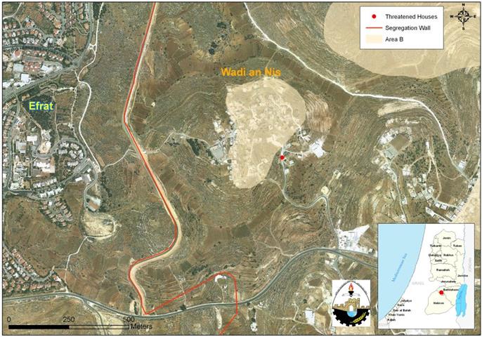
On March 12, 2010, six Palestinian families from Wad Al Nis village south of Bethlehem city received new halt of construction orders under the pretext of lacking building permit documents from the Israeli Civil Administration due to their location in area ‘C’ which falls under the complete Israeli control according to Oslo II Interim agreement. Owners of the houses are: Na’im Othman Abu Hammad, Amer Yaser Mahmoud, Muhammad Musa Au Hammad, Muhammad Musa Abu Hammad, Adlah Musa Hammad, Sameer Muhammad Issa and Hani Muhammad Issa. Map 1 below shows the location of one house, composed of two floors, that was targeted by the Israeli Occupation army with halt of construction order.
Map 1: Location of one house threatened of demolition in Wadi An Nis Village
Historical Lead Up
In December 1987, the first Palestinian Intifada broke out carrying the message of rejecting the Israeli Occupation, at the same time, called for a resolution to the Israeli – Palestinian conflict. The Palestinian people accepted the discourse of peaceful negotiations based on the grounds outlined in the Madrid Conference of 1991
. The guiding principles of these negotiations were ‘
Land for Peace‘ and the United Nations Resolutions
242[ and 338. After several rounds of talks in Washington D.C, the PLO and 338. After several rounds of talks in Washington D.C, the PLO and 338. After several rounds of talks in Washington D.C, the PLO and Israel were able to come out with the Declaration of Principles (DOP) agreement, which was signed in September 1993. The DOP called for an interim period of 5 years during which the representatives of the Palestinian people and the Israeli government will initiate negotiations over the final status, which include Jerusalem, refugees, settlements, borders and water. The two parties also agreed that ‘
neither party should initiate any action during the interim period that might jeopardize the outcome of final status negotiations‘.
The ‘Oslo II’ agreement, signed in Washington D.C. in September of 1995, sets out the interim stage for Palestinian Autonomy in the West Bank and Gaza, pending ‘final status negotiations’ which were scheduled to begin in May 1996 and finish by May 1999. The Interim Agreement states that the first phase of the Israeli military forces redeployment will be completed prior to the eve of the Palestinian elections, i.e., 22 days before the day of the elections. The further redeployments were to be completed within 18 months from the date of the inauguration of the Council. During this time, the powers and responsibilities relating to territory will be transferred gradually to Palestinian jurisdiction to cover West Bank and Gaza Strip territory, except for the issues that will be negotiated in the permanent status negotiations (i.e. Jerusalem and the Settlements). This meant that 95 % of the West Bank and Gaza should have become under Palestinian control 18 months after the inauguration of the Council. However, on the ground, this did not happen. Stalling of negotiations and delays as well as renegotiation of what was already agreed upon led to partial Israeli withdrawals. So, by March 2000 the areas under effective Palestinian control amounted to no more than 18.3 % which constitutes areas ‘A’; while 17.7% of the remaining area is area ‘B’, and 61% area ‘C’.
By that, Palestinians in Wadi An Nis village and else where in the Occupied Palestinian territory would have no problems with building issues if Israel committed itself to the agreements it signed with the Palestinians and transferred lands to Palestinian jurisdiction. Today the village of Wadi An Nis covers a total land area of 10437 dunums, where 99% of the land is classified as area C, while the remaining area was classified as Area B. See Table 1
.
| Table 1: Land classification of Wadi Al Nis village according to Oslo II Interim Agreement of 1995 |
| Area in % |
Area
(Dunum) |
Land Classification |
| 0 |
0 |
Area A |
| 1 |
102 |
Area B |
| 99 |
10335 |
Area C |
| 100 |
10437 |
Total Area |
|
Source : Geographical Information System, ARIJ 2010.
|
Table 1 shows that the only possible area slated for future urban expansion in Wadi An Nis village is the area classified as ‘B’ area; while ‘C’ area will be blocked for Palestinians to use because it will require them to go through a long list of demands by the Israeli Civil Administration in order to issue a building license. Until Palestinians owners are able to fulfill the demands of the ICA office, and documents are processed, years will pass without an answer to applicants, which in turn will force more Palestinians to build without licenses, as they are aware that their applications will be either ignored, or rejected, or postponed for not being able to meet the Israeli requirements. Therefore, Palestinians will fail to implement their development plans, including those barely enough to meet the natural growth requirements. Naturally this translates to more potential lands set for confiscation by the Israelis to use for settlements’ expansion, building bypass roads and other various Israeli purposes.
The Israeli settlement program in Wadi An Nis Village
Following Israel’s occupation of Palestinian territory in the year 1967, Israel launched its settlement program in the Palestinian territory with a view to strengthen its presence in the region and embarked on building settlements and military bases to protect existing settlements. The village of Wadi Al Nis was one of the Palestinian village which lost considerable areas of its lands for the building of a number of Israeli settlements as seen in Table 2:-
Table 2: Illegal Israeli settlements built on lands of Wadi Al Nis village
|
Settlement name
|
Date of establishment
|
Population
(2008)
|
Area occupied by settlement from village boundary
(Dunum)
|
|
Efrat
|
1979
|
8200
|
1713
|
|
Eli Eizaer
|
1975
|
1547
|
536
|
|
Rosh Tsorim
|
1969
|
485
|
3
|
|
Neve Daniel
|
1982
|
1760
|
556
|
|
Total
|
11992
|
2808
|
|
Source : Geographical Information System – ARIJ, 2010
* 1 Kilometer square = 1000 Dunums
|
Wadi An Nis village will also lose its lands for the construction of the Israeli Segregation Wall. The map that was published on the Israeli ministry of Defense website in 2007 showed that the majority of the village lands (9470 dunums, 90.7% of the total village area) will become isolated west of the Segregation wall, within the western Segregation Zone of Bethlehem Area which will encompass seven Palestinian communities and eleven Israeli settlements. See Map 2
Map 2: Wad Al Nis village surrounded with Illegal Israeli settlements
Once wall constructions are completed in the village, any movement from or to the isolated lands will be completely controlled by the Israeli occupation forces. Residents (population +865) will be segregated from their lands and livelihood because villagers of Wadi An Nis depend much on agriculture. Also entrance to the isolated agricultural lands will only be for farmers who will able to prove landownership through a credited Israeli organization (most likely to be the Israeli civil administration) and only the owners whose names listed in the ownership deeds (usually the eldest of the families) will receive permits. Furthermore, the Israeli civil administration will only issue permits on seasonal basis. Hence the owners will find a hard time to manage the cultivated lands on their own especially that the permits do not include additional labor or equipments.
To Conclude:
Over the last 43 years of Israeli occupation, the building without a permit pretext has been used by Israel to turn down indigenous Palestinians eligibility for permission to build while at the same time supporting the expansion of Israeli settlements in the Occupied Territory. This demonstrates a grave violation of International laws and Human conventions which called on Israel to stop demolition of Palestinian houses and destruction of Property. Art. 53 of the Fourth Geneva Convention indicates that ‘any destruction by the Occupying power of real or personal property belonging individually or collectively to private persons, or to the State, or other public authorities or social or cooperative organizations is prohibited, except where such destruction is rendered absolutely necessary by military operations.’Also Art. 147 of the Fourth Geneva Convention states that‘extensive destruction and appropriation of property not justified by military necessity and carried out unlawfully and wantonly is a grave breach of the Convention.’ As well as Art. 23 of the Hague Convention of 1907 which provides that’In addition to the prohibitions provided by special Conventions, it is especially forbidden to destroy or seize the enemy’s property, unless such destruction or seizure be imperatively demanded by the necessities of war’
:::::::::::::__
[1] Madrid Conference of 1991: Itwas hosted by the government of Spain and co-sponsored by the USA and the USSR. It convened on October 30, 1991 and lasted for three days. It was an early attempt by the international community to start a
peace process through negotiations involving
Israel and the
Palestinians as well as Arab countries including
Syria,
Lebanon, and
Jordan.
[2] UN Security Council Resolution 242 (1967): calling on Israel to withdraw from territories it occupied in the 1967 Six Day War, and, implicitly, on Palestinians to recognize Israel.
[3] United Nations Security Council Resolution 338, October 22, 1973:Calls upon all parties to present fighting to cease all firing and terminate all military activity immediately, no later than 12 hours after the moment of the adoption of this decision, in the positions after the moment of the adoption of this decision, in the positions they now occupy; Calls upon all parties concerned to start immediately after the cease-fire the implementation of Security Council Resolution 242 (1967) in all of its parts;
[4] Palestine Liberation Orgazanition
Prepared by


