• About The Project
  • Palestine in Century
  • Selected Maps
  • Glossary
  • About ARIJ
  • About LRC
  • By Year
    • Case Studies By Year
    • Daily Report By Year
Tuesday, June 9, 2026
POICA
No Result
View All Result
  • Home
  • Settlements
    • New Israeli Settlements
    • Settlement Expansion
  • Israeli Violations
    • Agriculture
    • Confiscation
    • Demolition
    • Environment
    • Eviction of Palestinians
    • Settlers Attacks
  • Bypass Roads
  • Israeli Plans
  • Segregation
    • Checkpoints
    • Closure
    • Separation Plans
  • Military Orders
  • Reports
    • Daily Report
    • Monthly Report
    • Quarterly Report
No Result
View All Result
POICA
No Result
View All Result

68 Recent Notifications in Al Farisiya

June 30, 2010
in Military Orders
68 Recent Notifications in Al Farisiya
Violation: eviction orders against 35 residential structures and 33 agricultural ones.
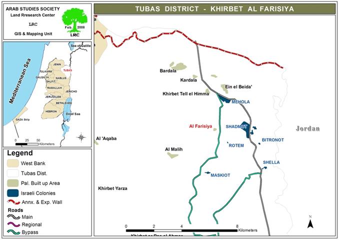
Location: Al Farisiya – Northern Jordan Valley to the east of Tubas.

Date: June 27, 2010.
Violators: the Israeli Occupation Army.
Victims:  more than 103 people including 62 children.
 
The series of aggressions against the residences of the Northern Jordan Valley region are unstoppable since it has been designated for massive colonial expansion by the Israeli Occupiers; the most recent victims were inhabitants of Al Farisiya.
 
A glance on the lifestyle people are leading there and the simple houses they use as shelters reflects the agony caused by the Israeli measures in the area.
Picture 1: Al Farisiya overview
 
The merciless and ruthless conquerors never hesitate to expel people, attack them physically, and deprive them from the water sources rendering their lives miserable. Residents of Al Farisiya own deeds that were issued by the Jordanian Government (which was controlling the West Bank before the Israeli conquest in 1967) proving the ownership of their land.
 
Nevertheless, the deeds were never able to protect the people from an enemy who has not yet learned the meaning of words like justice, law, and dignity. The Israeli have already driven hundreds of families out of the area and they are scheming to eject who is left.
 
The Israelis have utilized several brutal methods in order to cleanse the area of its Palestinian residents, clearing the way for the illegal colonial expansion. They [the Israelis] spread tens of mine fields, announcing thousands of dunums as closed military zones, rendering these areas unreachable.
 
Also, they demolished hundreds of structures under the pretext of ‘no permits’ in areas classified ‘C’ according to Oslo accords which the Israeli abide with this term of the agreement only.
 
Details:
On June 27, 2010, Israeli troops broke into the nomads gathering of Al Farisiya and handed 10 families eviction orders to be carried out within 24 hours; claiming that they are living in a ‘military zone’ neglecting the fact that they have ownership deeds. Now, the residents are facing to extremes, either they pack and leave or they keep living in continuous anxiety, waiting for the Israeli dozers to come and destroy their structures.
 
No.
Victim
Residential structures
Agricultural structures
Family members
Children
comments
1
Salih Daraghmah
4
6
17
13
Order 1
2
Mohammad Daraghmah
3
4
11
7
Order 2
3
Yasin Daraghmah
5
4
14
9
Order 3
4
Fa’iq Daraghmah
1
1
2
0
Order 4
5
‘Adel Ulayyan
3
2
5
3
Order 5
6
Hamad ‘Awad
7
5
15
7
Order 6
7
Mohammad ‘Awad
3
2
4
2
 
8
Zyad Sawatfa
2
2
9
5
Structures received permits from the Israeli Civil Administration/
Order 7
9
Hasan abu Odeh
4
3
11
7
Order 8
10
‘Adnan Daraghmah
3
4
15
9
Order 9
Total
35
33
103
62
 
*source: LRC –field research
 
Al Farisiya is located in Wadi al Malih region, 20 km to the east of Tubas city.  Before 1967, more than 1000 people used to inhabit the area, depending mainly on herding and agriculture in their living. Now, only 242 people are still residing there.
 
Large area of Al Farisiya has been turned into ‘military zones’ by the Israeli Occupation Army. Moreover, the Israelis laid their hands on all the water springs in the area for the sake of nearby colonies of Meskiot and Shidmot Makhola. Also, the Israeli have turned the eastern part of Al Farisiya into a huge mine field which endangers the life of people around it.
 
Pic 2+3: Khirbat al-Farsiya area a closed military


Prepared by
The Land Research Center
LRC


Recommended For You

سلطات الاحتلال الإسرائيلي بصدد الاستيلاء على موقع قبر النبي صموئيل شمال غرب مدينة القدس

by arij
May 23, 2026
0
سلطات الاحتلال الإسرائيلي بصدد الاستيلاء على موقع قبر النبي صموئيل شمال غرب مدينة القدس

 نشرت سلطات الاحتلال الإسرائيلي في الثامن عشر من شهر أيار من العام 2026 اعلانا مفاده الاستيلاء على الأراضي الفلسطينية في قرية النبي صموئيل شمال غرب القدس المحتلة. وجاء...

Read moreDetails

إقامة منطقة عسكرية عسكرية داخل أراضي (أ) في جنين

by arij
May 19, 2026
0
إقامة منطقة عسكرية عسكرية داخل أراضي (أ) في جنين

   في السابع من شهر أيار من العام 2026، وزعت سلطات الاحتلال الإسرائيلي أمرا عسكريا جديدة على أهالي مدينة جنين يقضي بمصادرة 7.2 دونما من الأراضي الفلسطينية في...

Read moreDetails

“بمساحة اجمالية 177 دونما من أرضي البيرة وبيتين”, طريق استيطاني لخدمة البؤر الاستيطانية في محافظة رام الله

by arij
May 18, 2026
0
“بمساحة اجمالية 177 دونما من أرضي البيرة وبيتين”, طريق استيطاني لخدمة البؤر الاستيطانية في محافظة رام الله

في الحادي عشر من شهر أيار من العام 2026, نشرت دائرة أراضي إسرائيل اعلانا جديدا يقضي بمصادرة المزيد من الأراضي الفلسطينية في محافظة رام الله لأغراض استيطانية في...

Read moreDetails

“في خدمة مستوطنة ناحال حيلتس”, طريق استيطاني إسرائيلي جديد على أراضي بتير وبيت جالا في محافظة بيت لحم

by arij
May 18, 2026
0
“في خدمة مستوطنة ناحال حيلتس”, طريق استيطاني إسرائيلي جديد على أراضي بتير وبيت جالا في محافظة بيت لحم

تواصل سلطات الاحتلال الإسرائيلي إحكام سيطرتها على المزيد من الأراضي الفلسطينية في الضفة الغربية المحتلة، وهذه المرة من خلال استهداف أراضي محافظة بيت لحم. ففي السادس والعشرين من...

Read moreDetails

مناطق نفوذ المستوطنات ودورها في إعادة تشكيل الجغرافيا الفلسطينية

by arij
April 23, 2026
0
مناطق نفوذ المستوطنات ودورها في إعادة تشكيل الجغرافيا الفلسطينية

أصدرت سلطات الاحتلال الإسرائيلي في العاشر من شهر نيسان 2026 الكراسة رقم (273)، وهي وثيقة تضم مجموعة من المناشير والأوامر والتعيينات الإسرائيلية المتعلقة بالجوانب الأمنية والعسكرية والإدارية، إضافة...

Read moreDetails
Next Post
إخطار 68 منشأة سكنية وزراعية  بالإخلاء في خربة الفارسية

إخطار 68 منشأة سكنية وزراعية بالإخلاء في خربة الفارسية

LATEST NEWS

سلطات الاحتلال الإسرائيلي بصدد الاستيلاء على موقع قبر النبي صموئيل شمال غرب مدينة القدس

سلطات الاحتلال الإسرائيلي بصدد الاستيلاء على موقع قبر النبي صموئيل شمال غرب مدينة القدس

by arij
May 23, 2026
0

........................................................

إقامة منطقة عسكرية عسكرية داخل أراضي (أ) في جنين

إقامة منطقة عسكرية عسكرية داخل أراضي (أ) في جنين

by arij
May 19, 2026
0

........................................................

الآثار كأداة للضم الزاحف: مشروع القانون الإسرائيلي لإعادة هندسة الجغرافيا والهوية في الضفة الغربية

الآثار كأداة للضم الزاحف: مشروع القانون الإسرائيلي لإعادة هندسة الجغرافيا والهوية في الضفة الغربية

by arij
May 23, 2026
0

........................................................

النكبة الفلسطينية في ذكراها الثامنة والسبعين: من التطهير العرقي إلى الإبادة وإعادة هندسة الجغرافيا الفلسطينية 

النكبة الفلسطينية في ذكراها الثامنة والسبعين: من التطهير العرقي إلى الإبادة وإعادة هندسة الجغرافيا الفلسطينية 

by arij
May 18, 2026
0

........................................................

flag_yellow_lowEU-PfP-Logo

This website and its content were initiated in 1993 by the Applied Research Institute – Jerusalem (ARIJ) and the Land Research Center (LRC) with the support from the European Union up until 2023. Since then, the Applied Research Institute – Jerusalem (ARIJ) has taken over the continued development and maintenance of the website. The views expressed remain solely those of ARIJ) and do not necessarily reflect those of the European Union.

© 2026 Copyright | ARIJ | All Rights reserved.

No Result
View All Result
  • Home
  • Settlements
    • New Israeli Settlements
    • Settlement Expansion
  • Israeli Violations
    • Agriculture
    • Confiscation
    • Demolition
    • Environment
    • Eviction of Palestinians
    • Settlers Attacks
  • Bypass Roads
  • Israeli Plans
  • Segregation
    • Checkpoints
    • Closure
    • Separation Plans
  • Military Orders
  • Reports
    • Daily Report
    • Monthly Report
    • Quarterly Report

© 2026 Copyright | ARIJ | All Rights reserved.