• About The Project
  • Palestine in Century
  • Selected Maps
  • Glossary
  • About ARIJ
  • About LRC
  • By Year
    • Case Studies By Year
    • Daily Report By Year
Tuesday, June 9, 2026
POICA
No Result
View All Result
  • Home
  • Settlements
    • New Israeli Settlements
    • Settlement Expansion
  • Israeli Violations
    • Agriculture
    • Confiscation
    • Demolition
    • Environment
    • Eviction of Palestinians
    • Settlers Attacks
  • Bypass Roads
  • Israeli Plans
  • Segregation
    • Checkpoints
    • Closure
    • Separation Plans
  • Military Orders
  • Reports
    • Daily Report
    • Monthly Report
    • Quarterly Report
No Result
View All Result
POICA
No Result
View All Result

Ethnic Cleansing in Ar Rashayda Village

March 21, 2011
in Military Orders
Ethnic Cleansing in Ar Rashayda Village
On the 19th of March 2011, the Israeli Civil Administration delivered orders to Odeh Family in Ras Imteirda area in Arab Al Rashayda village southeast of Bethlehem city. The orders included the demolition of residential tents, barracks, and old caves used for cattle raising. The threatened properties belong to Ali Odeh Muhammad Al Rashayda, a father of 50 family members, and his son Muhammad Ali Odeh Al Rashayda.
 
Mr. Ali Al Rashayda stated that the Israeli Occupation Authorities claim that Al Rashayda family violated the borders that fall under their exclusive sovereignty which were determined by the Oslo II Interim Agreement of 1995. He added that the Israeli Borders’ signs are away from their properties about 450 meters and that the delivered orders are only initial steps towards evacuating the area from its habitant, and suffocating them in order to leave, leading at the end to the full Israeli Military control over the land.
 
Not forgetting to mention that these procedures will lead to the forbiddance of getting benefit from the livestock in the area, where these livestock are considered the main and lonely source of income to families living in the area.  Table 1 gives details of the threatened facilities and their owners in Ar Rashayda village.
 
Table 1: the threatened facilities and their owners in Arab Ar Rashayda village
No.
Owner
Facility
Area (m²)
Date of Building
No. of Family
members
1
Muhammad Al Rashayda
Livestock Barracks
80
01-07-2008
 
2
Muhammad Al Rashayda
Livestock Barracks
30
01-06-2009
 
3
Muhammad Al Rashayda
Livestock Barracks
30
01-06-2009
 
4
Muhammad Al Rashayda
Solar Energy Unit
6
01-09-2010
 
5
Muhammad Al Rashayda
Residential wooden house
25
01-04-2000
12 members
6
Muhammad Al Rashayda
Residential tent
96
01-05-2007
12 members
7
Ali Odeh Al Rashayda
Livestock Barracks
25
01-06-1996
 
8
Ali Odeh Al Rashayda
Residential tent
45
01-06-1996
10 members
9
Ali Odeh Al Rashayda
Residential house
16
01-06-1996
3 members
10
Ali Odeh Al Rashayda
Residential house
20
01-06-1996
3 members
Source: Arab Al Rashayda Residence
 
 
 Map 1: the threatened structures in Arab Ar Rashayda village southeast of Bethlehem city


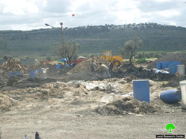
Photo 1-4: Photos of the threatened properties in Arab Al Rashayda Village.
Source: ARIJ Field Team – 2011
 
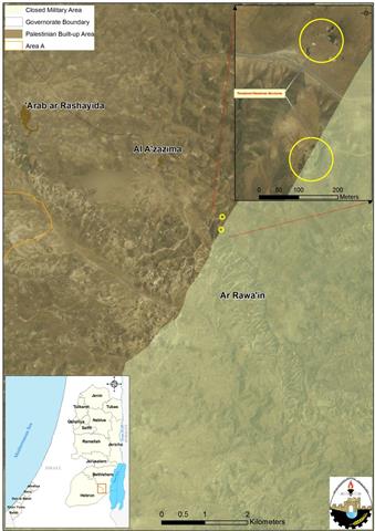
Also on the 23rd of March 2011, the Israeli Civil Administration, accompanied by Israeli Occupation Forces and bulldozers demolished two water wells in Al Hatata area in Kisan village southeast of Bethlehem city. The demolished wells belong to Yousef Muhammad Salem Al Rashayda and Majed Falah Hidewi Al Rashayda. The water wells hold capacity of 900 cubic meters and serve 15 family members and the livestock. The wells were notified with demolition orders in the beginning of February 2011. Map 2, shows the location of the demolished wells.
 
Map 2: Arab Al Rashayda demolished wells
 
Arab Al Rashayda, Location and population 
Arab Al Rashayda village, is located around 19 km southeast of Bethlehem City. It is bordered by Kisan village lands from the east, Kisan village and Ma’ale ‘Amos settlement from the north, Sa’ir town lands from the west, and Bani Na’im town from the south.  The village is located at an altitude of 512 meters above sea level with a mean annual rainfall of 246mm. The average annual temperature is 19.2 C, and the average annual humidity is about 58 % percent. See Map 3
 
Map 3: Arab Al Rashayda village – ARIJ
Source: The Geo-graphical Information System Department, ARIJ 2011
 
 
Arab Al Rashayda village is like many Palestinian communities in the Jordan Valley that are located in the areas classified by the Israelis as ‘Closed Military Area’. It is worth mentioning that 95.1% of the total area of the West Bank’s eastern part (1664 square km) is controlled by Israel, of which 855.5 (51.4%) were classified as closed military areas since the 1967 Israeli occupation of the West Bank. Palestinians living in these areas were denied building rights and land utilization and face the threat of evacuation and displacement.
 
The Israeli policies in all their forms towards Palestinians are considered illegal, and violate international law and Human Rights conventions, of which, the 4th Geneva convention of 1949, article 49 which states that: ‘Individual or mass forcible transfers, as well as deportations of protected persons from occupied territory to the territory of the Occupying Power or to that of any other country, occupied or not, are prohibited, regardless of their motive‘. Also The right to respect for one’s property is set out in:
  • Article 17 of the Universal Declaration of Human Rights, which says “no one shall be arbitrarily deprived of his property”.
  • Article 46 of the 1907 Hague Regulations states that the occupying power must respect private property, which cannot be “confiscated.”
  • Article 53 of the Fourth Geneva Convention says “destruction” by Occupying Power of private property is prohibited, unless “absolutely necessary” in military operations.
 

:::::::::::::::::__
[1] Convention (IV) relative to the Protection of Civilian Persons in Time of War. Geneva, 12 August 1949
http://www.icrc.org/ihl.nsf/WebART/380-600056
[2] Separate and Unequal, 20 December 2010  


Prepared by:
The Applied Research Institute – Jerusalem

Recommended For You

“لصالح معسكر إسرائيلي”, سلطات الاحتلال الإسرائيلي العمل بأمر عسكري لتعميق المشروع الاستيطاني في محافظة طوباس

by arij
June 9, 2026
0
“لصالح معسكر إسرائيلي”, سلطات الاحتلال الإسرائيلي العمل بأمر عسكري لتعميق المشروع الاستيطاني في محافظة طوباس

سلّمت سلطات الاحتلال الإسرائيلي، في السابع من حزيران 2026، أهالي مدينة طوباس شمال الضفة الغربية المحتلة أمراً عسكرياً جديداً بعنوان: "أمر بشأن وضع اليد على أراضٍ رقم 79/26/ت...

Read moreDetails

الاحتلال يرسّخ بؤرة “يتسيف” الاستيطانية عبر تخصيص 92 دونماً من أراضي بيت ساحور

by arij
June 9, 2026
0
الاحتلال يرسّخ بؤرة “يتسيف” الاستيطانية عبر تخصيص 92 دونماً من أراضي بيت ساحور

أصدر جيش الاحتلال الإسرائيلي في الخامس من شهر اذار من العام 2026 إعلاناً عسكرياً جديداً موقع من قبل ما يُسمّى بـ “قائد قوات جيش الدفاع الإسرائيلي في منطقة...

Read moreDetails

كراسة أوامر إسرائيلية جديدة تمهد لمصادرة أكثر من 20 ألف دونم في الضفة الغربية المحتلة

by arij
June 9, 2026
0
كراسة أوامر إسرائيلية جديدة تمهد لمصادرة أكثر من 20 ألف دونم في الضفة الغربية المحتلة

في الخامس من شهر اذار من العام 2026، أصدرت سلطات الاحتلال الإسرائيلي كراسة جديدة من الأوامر العسكرية التي تهدف إلى توسيع نطاق النشاطات الاستيطانية على الأراضي الفلسطينية، وذلك...

Read moreDetails

سلطات الاحتلال الإسرائيلي بصدد الاستيلاء على موقع قبر النبي صموئيل شمال غرب مدينة القدس

by arij
May 23, 2026
0
سلطات الاحتلال الإسرائيلي بصدد الاستيلاء على موقع قبر النبي صموئيل شمال غرب مدينة القدس

 نشرت سلطات الاحتلال الإسرائيلي في الثامن عشر من شهر أيار من العام 2026 اعلانا مفاده الاستيلاء على الأراضي الفلسطينية في قرية النبي صموئيل شمال غرب القدس المحتلة. وجاء...

Read moreDetails

إقامة منطقة عسكرية عسكرية داخل أراضي (أ) في جنين

by arij
May 19, 2026
0
إقامة منطقة عسكرية عسكرية داخل أراضي (أ) في جنين

   في السابع من شهر أيار من العام 2026، وزعت سلطات الاحتلال الإسرائيلي أمرا عسكريا جديدة على أهالي مدينة جنين يقضي بمصادرة 7.2 دونما من الأراضي الفلسطينية في...

Read moreDetails
Next Post
The Israeli Occupation Notifies 18 coal-production facilities

The Israeli Occupation Notifies 18 coal-production facilities

LATEST NEWS

“لصالح معسكر إسرائيلي”, سلطات الاحتلال الإسرائيلي العمل بأمر عسكري لتعميق المشروع الاستيطاني في محافظة طوباس

“لصالح معسكر إسرائيلي”, سلطات الاحتلال الإسرائيلي العمل بأمر عسكري لتعميق المشروع الاستيطاني في محافظة طوباس

by arij
June 9, 2026
0

........................................................

الاحتلال يرسّخ بؤرة “يتسيف” الاستيطانية عبر تخصيص 92 دونماً من أراضي بيت ساحور

الاحتلال يرسّخ بؤرة “يتسيف” الاستيطانية عبر تخصيص 92 دونماً من أراضي بيت ساحور

by arij
June 9, 2026
0

........................................................

كراسة أوامر إسرائيلية جديدة تمهد لمصادرة أكثر من 20 ألف دونم في الضفة الغربية المحتلة

كراسة أوامر إسرائيلية جديدة تمهد لمصادرة أكثر من 20 ألف دونم في الضفة الغربية المحتلة

by arij
June 9, 2026
0

........................................................

سلطات الاحتلال الإسرائيلي بصدد الاستيلاء على موقع قبر النبي صموئيل شمال غرب مدينة القدس

سلطات الاحتلال الإسرائيلي بصدد الاستيلاء على موقع قبر النبي صموئيل شمال غرب مدينة القدس

by arij
May 23, 2026
0

........................................................

flag_yellow_lowEU-PfP-Logo

This website and its content were initiated in 1993 by the Applied Research Institute – Jerusalem (ARIJ) and the Land Research Center (LRC) with the support from the European Union up until 2023. Since then, the Applied Research Institute – Jerusalem (ARIJ) has taken over the continued development and maintenance of the website. The views expressed remain solely those of ARIJ) and do not necessarily reflect those of the European Union.

© 2026 Copyright | ARIJ | All Rights reserved.

No Result
View All Result
  • Home
  • Settlements
    • New Israeli Settlements
    • Settlement Expansion
  • Israeli Violations
    • Agriculture
    • Confiscation
    • Demolition
    • Environment
    • Eviction of Palestinians
    • Settlers Attacks
  • Bypass Roads
  • Israeli Plans
  • Segregation
    • Checkpoints
    • Closure
    • Separation Plans
  • Military Orders
  • Reports
    • Daily Report
    • Monthly Report
    • Quarterly Report

© 2026 Copyright | ARIJ | All Rights reserved.