• About The Project
  • Palestine in Century
  • Selected Maps
  • Glossary
  • About ARIJ
  • About LRC
  • By Year
    • Case Studies By Year
    • Daily Report By Year
Tuesday, June 9, 2026
POICA
No Result
View All Result
  • Home
  • Settlements
    • New Israeli Settlements
    • Settlement Expansion
  • Israeli Violations
    • Agriculture
    • Confiscation
    • Demolition
    • Environment
    • Eviction of Palestinians
    • Settlers Attacks
  • Bypass Roads
  • Israeli Plans
  • Segregation
    • Checkpoints
    • Closure
    • Separation Plans
  • Military Orders
  • Reports
    • Daily Report
    • Monthly Report
    • Quarterly Report
No Result
View All Result
POICA
No Result
View All Result

The Confiscation of Umm Salamona, Wad Rahhal and Wadi Al Nis Lands – Bethlehem Governorate

December 30, 2011
in Military Orders
Violation: “Placing Hands” on 127 dunums of agricultural lands.
Locations: Umm Salamona, Wad Rahal and Wadi Al Nis in the Governorate of Bethlehem.
Date: The end of December, 2011.
 
Preface:
The village of Wadi Al Nis is located about 10 kilometers south of the city of Bethlehem. It has a secondary school, a charitable society and two stone factories in which a quarter of the village’s man power works. The remaining workforce works inside of Israel. The village is surrounded by the colony of Efrat from the west as well as by the Israeli Racist Isolation Wall. The presence of the colony and the Wall coupled with numerous flying checkpoints leads to the inability of the residents of the village to move around and about freely.
 
As for the village of Wad Rahhal, it is located 5.7 kilometers south of Bethlehem. The village of Janata borders it from the east, al Khader from the north, Wadi Al Nis in the west and by the village of Jourat Al Shama’a from the south. In terms of Umm Salamona, it is located at 894 meters above sea level with an average rainfall of 643 mlm.
 
Details:
In the end of December 2011, a “Placing Hands” order was found by some of the herders of the said villages. In the village of Umm Salamona, the affected lands belong to 7 families (Ahmad Mohammad Issa, Musa Mohammad Issa Taqatqa, Othman Mohammad Issa Taqatqa, Khalil Muhammad Issa Taqatqa, Ali Khader Issa Taqatqa, Issa Khader Issa Taqatqa and Mahmoud Mohammad Issa Taqata). The area of the targeted lands is about 73 dunums. The owners of the lands objected to the Orders through hiring the lawyer Ghayyath Naser. The pretext used for placing the hands is due to its close proximity of the said lands to the Racist Wall.


Pic.1+2: The threatened lands in Umm Salomona
 
As for the village of Wadi Rahhal, the threatened lands are owned by 6 families in the village (the sons of Mr. Abdullah Abdel Rahman Al Hajj). The area of the Al Hajj lands is 14 dunums. An additional 9 dunums are threatened and is owned by the sons of Mr. Suleiman Abdel Rahman Al Hajj. After the farmers found the Order laying around beneath a rock in their lands. An objection to the order was filed.
 
  
Pic.3+4: Wadi Rahhal threatened lands.
 
Finally, the area threatened lands of Wadi Al Nis is around 40 dunums owned by 6 families in the village including the sons of Mr. Mohammad Musa Khalili Hammad. Again, the families hired Mr. Ghayyath Nasser to represent them in front of the Israeli legal apparatuses.
 
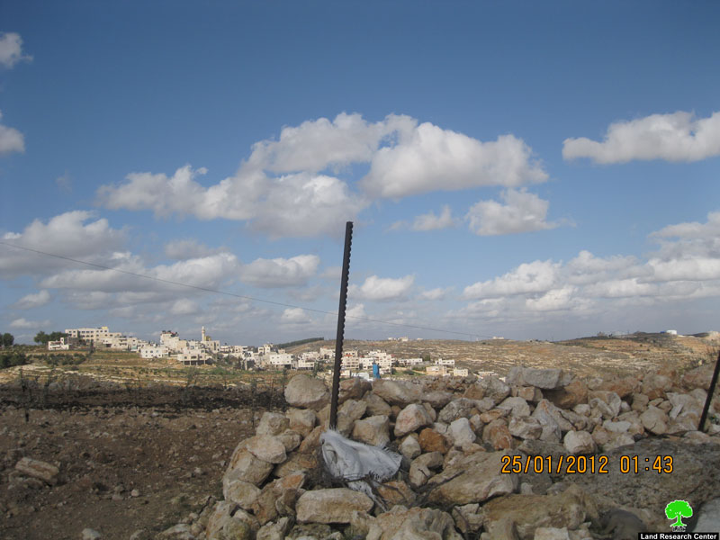
Pic.5: The threatened lands of Wadi Al Niss.
 
Finally, it has to be pointed out that most of the threatened lands are planted with olive trees.
 
 
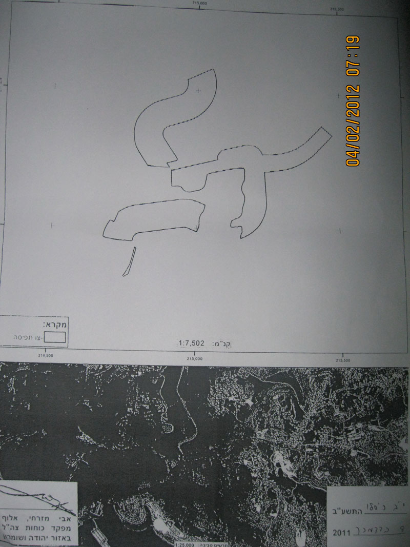
Pic.6+7: The map associated with Order T/06/69 for the three villages
Prepared by
The Land Research Center
LRC

Recommended For You

“لصالح معسكر إسرائيلي”, سلطات الاحتلال الإسرائيلي العمل بأمر عسكري لتعميق المشروع الاستيطاني في محافظة طوباس

by arij
June 9, 2026
0
“لصالح معسكر إسرائيلي”, سلطات الاحتلال الإسرائيلي العمل بأمر عسكري لتعميق المشروع الاستيطاني في محافظة طوباس

سلّمت سلطات الاحتلال الإسرائيلي، في السابع من حزيران 2026، أهالي مدينة طوباس شمال الضفة الغربية المحتلة أمراً عسكرياً جديداً بعنوان: "أمر بشأن وضع اليد على أراضٍ رقم 79/26/ت...

Read moreDetails

الاحتلال يرسّخ بؤرة “يتسيف” الاستيطانية عبر تخصيص 92 دونماً من أراضي بيت ساحور

by arij
June 9, 2026
0
الاحتلال يرسّخ بؤرة “يتسيف” الاستيطانية عبر تخصيص 92 دونماً من أراضي بيت ساحور

أصدر جيش الاحتلال الإسرائيلي في الخامس من شهر اذار من العام 2026 إعلاناً عسكرياً جديداً موقع من قبل ما يُسمّى بـ “قائد قوات جيش الدفاع الإسرائيلي في منطقة...

Read moreDetails

كراسة أوامر إسرائيلية جديدة تمهد لمصادرة أكثر من 20 ألف دونم في الضفة الغربية المحتلة

by arij
June 9, 2026
0
كراسة أوامر إسرائيلية جديدة تمهد لمصادرة أكثر من 20 ألف دونم في الضفة الغربية المحتلة

في الخامس من شهر اذار من العام 2026، أصدرت سلطات الاحتلال الإسرائيلي كراسة جديدة من الأوامر العسكرية التي تهدف إلى توسيع نطاق النشاطات الاستيطانية على الأراضي الفلسطينية، وذلك...

Read moreDetails

سلطات الاحتلال الإسرائيلي بصدد الاستيلاء على موقع قبر النبي صموئيل شمال غرب مدينة القدس

by arij
May 23, 2026
0
سلطات الاحتلال الإسرائيلي بصدد الاستيلاء على موقع قبر النبي صموئيل شمال غرب مدينة القدس

 نشرت سلطات الاحتلال الإسرائيلي في الثامن عشر من شهر أيار من العام 2026 اعلانا مفاده الاستيلاء على الأراضي الفلسطينية في قرية النبي صموئيل شمال غرب القدس المحتلة. وجاء...

Read moreDetails

إقامة منطقة عسكرية عسكرية داخل أراضي (أ) في جنين

by arij
May 19, 2026
0
إقامة منطقة عسكرية عسكرية داخل أراضي (أ) في جنين

   في السابع من شهر أيار من العام 2026، وزعت سلطات الاحتلال الإسرائيلي أمرا عسكريا جديدة على أهالي مدينة جنين يقضي بمصادرة 7.2 دونما من الأراضي الفلسطينية في...

Read moreDetails
Next Post

ARIJ Daily Report - Sat, 31/12/2011

LATEST NEWS

“لصالح معسكر إسرائيلي”, سلطات الاحتلال الإسرائيلي العمل بأمر عسكري لتعميق المشروع الاستيطاني في محافظة طوباس

“لصالح معسكر إسرائيلي”, سلطات الاحتلال الإسرائيلي العمل بأمر عسكري لتعميق المشروع الاستيطاني في محافظة طوباس

by arij
June 9, 2026
0

........................................................

الاحتلال يرسّخ بؤرة “يتسيف” الاستيطانية عبر تخصيص 92 دونماً من أراضي بيت ساحور

الاحتلال يرسّخ بؤرة “يتسيف” الاستيطانية عبر تخصيص 92 دونماً من أراضي بيت ساحور

by arij
June 9, 2026
0

........................................................

كراسة أوامر إسرائيلية جديدة تمهد لمصادرة أكثر من 20 ألف دونم في الضفة الغربية المحتلة

كراسة أوامر إسرائيلية جديدة تمهد لمصادرة أكثر من 20 ألف دونم في الضفة الغربية المحتلة

by arij
June 9, 2026
0

........................................................

سلطات الاحتلال الإسرائيلي بصدد الاستيلاء على موقع قبر النبي صموئيل شمال غرب مدينة القدس

سلطات الاحتلال الإسرائيلي بصدد الاستيلاء على موقع قبر النبي صموئيل شمال غرب مدينة القدس

by arij
May 23, 2026
0

........................................................

flag_yellow_lowEU-PfP-Logo

This website and its content were initiated in 1993 by the Applied Research Institute – Jerusalem (ARIJ) and the Land Research Center (LRC) with the support from the European Union up until 2023. Since then, the Applied Research Institute – Jerusalem (ARIJ) has taken over the continued development and maintenance of the website. The views expressed remain solely those of ARIJ) and do not necessarily reflect those of the European Union.

© 2026 Copyright | ARIJ | All Rights reserved.

No Result
View All Result
  • Home
  • Settlements
    • New Israeli Settlements
    • Settlement Expansion
  • Israeli Violations
    • Agriculture
    • Confiscation
    • Demolition
    • Environment
    • Eviction of Palestinians
    • Settlers Attacks
  • Bypass Roads
  • Israeli Plans
  • Segregation
    • Checkpoints
    • Closure
    • Separation Plans
  • Military Orders
  • Reports
    • Daily Report
    • Monthly Report
    • Quarterly Report

© 2026 Copyright | ARIJ | All Rights reserved.