
• About The Project
  • Palestine in Century
  • Selected Maps
  • Glossary
  • About ARIJ
  • About LRC
  • By Year
    • Case Studies By Year
    • Daily Report By Year
Sunday, August 16, 2026
POICA
No Result
View All Result
  • Home
  • Settlements
    • New Israeli Settlements
    • Settlement Expansion
  • Israeli Violations
    • Agriculture
    • Confiscation
    • Demolition
    • Environment
    • Eviction of Palestinians
    • Settlers Attacks
  • Bypass Roads
  • Israeli Plans
  • Segregation
    • Checkpoints
    • Closure
    • Separation Plans
  • Military Orders
  • Reports
    • Daily Report
    • Monthly Report
    • Quarterly Report
  • Home
  • Settlements
    • New Israeli Settlements
    • Settlement Expansion
  • Israeli Violations
    • Agriculture
    • Confiscation
    • Demolition
    • Environment
    • Eviction of Palestinians
    • Settlers Attacks
  • Bypass Roads
  • Israeli Plans
  • Segregation
    • Checkpoints
    • Closure
    • Separation Plans
  • Military Orders
  • Reports
    • Daily Report
    • Monthly Report
    • Quarterly Report
No Result
View All Result
POICA
No Result
View All Result

Extension of a Confiscation Order
Converting over 3000 dunums into closed military zones.

April 5, 2012
in Military Orders
Extension of a Confiscation Order  Converting over 3000 dunums into closed military zones.
Violation: converting over 3000 dunums into closed military zones.
Location: the villages of Az Zawiyya, Deir Ballout, and Rafat in Salfit.
Date: April 1, 2012.
Perpetrators: the Israeli Occupation Army.
 
Details:
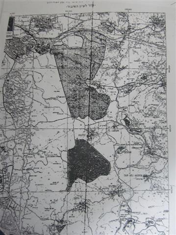
On April 1, 2012, the Israeli Occupation Authorities handed the so-called Palestinian Civil Coordination Office a renewal for a confiscation order of over 3000 dunums in Salfit. The order entitled ‘closure order (prohibition of entry and trespassing) number T/3/93, adjusting borders’ which was issued in 1993 ordered the continuity of confiscation of over 3000 dunums of Salfit lands.
 
   
Picture: the order and the enclosed map
 
Khader Shqer, Az Zawiyya Governor, said: ‘the very Palestinian existence in the area is at stake here, for Az Zawiyya, we lost over 5000 dunums for the construction of the segregation wall which was aroused in Jabal al Kroum area, to the west. The Israelis tried many times to capture the lands and only the determination of the town folks stood in their way. As a result, they used a different approach; they turned most of the village area into a military zone using various ‘security’ justifications knowing that the town has a strategic location overlooking areas west of the wall in addition to the availability of water and fertile lands.  The order is a proof to the Israeli intentions to continue their land confiscation and judaization policy. Az Zawiyya alone will lose an extra 2000 dunums added to what it already lost’.
 
Salfit Governorate:
Salfit’s total area is 202.1 km 2, inhabited by 59570 (PCBS 2007). Salfit’s towns and villages are ripped apart because of the Israeli colonization policy and the spread of colonies and bypasses. Colonization started as early as 1975 in Salfit because of its strategic location. It started with tiny outposts which expanded to become as large as cities bigger than Salfit city itself. Now, colonization has reached extremely alarming levels as colonies are steps away from Palestinian houses in some areas.
 
Colonization in Salfit:
The colonial invasion of Salfit started in the 1970’s; Israel started bringing into the area Jewish colonists coming from all around the world in order to imbalance the demographic status of Salfit. The rapid increase in the number of colonists has never been natural; it has been a result of pumping colonists into the area by giving them extreme privileges and facilitating acquiring lands and work for them. The colonial policy in Salfit was intended to split the West Bank into halves as well as taking over the fertile agricultural lands and the rich water sources.
 
On April 12, 2004, the Israeli Prime Minister at the time, Ariel Sharon, declared that Ariel colony and colonies around it will forever be under Israeli political and security control meaning that the danger Salfit is facing is permanent. The Israeli colonies created disconnection between the Palestinian communites which had drastic effects on the geographic, political, social, and economic status in the governorate. It also hindered development and rendered any expansion in Palestinian communities next to impossible.
 
Prepared by
The Land Research Center
LRC


Recommended For You

” 118 ألف دونم مهددة بالعزل في محافظة طوباس”
إسرائيل تستكمل مشروع “الخط القرمزي” وتوسع عزل الأراضي الفلسطينية شرق الضفة الغربية المحتلة

by arij
July 29, 2026
0
” 118 ألف دونم مهددة بالعزل في محافظة طوباس”  إسرائيل تستكمل مشروع “الخط القرمزي” وتوسع عزل الأراضي الفلسطينية شرق الضفة الغربية المحتلة

  بعد مرور تسعة أشهر على إصدار سلطات الاحتلال الإسرائيلي مجموعة من الأوامر العسكرية التي استهدفت إنشاء ما أصبح يُعرف بين الفلسطينيين بـ “الخط القرمزي" في منطقة الأغوار...

Read moreDetails

الاحتلال الاسرائيلي يوسع سيطرته على أراضي جبل الفرديس بمصادرة 317 دونم اخرى

by arij
June 15, 2026
0
الاحتلال الاسرائيلي يوسع سيطرته على أراضي جبل الفرديس بمصادرة 317 دونم اخرى

  في الخامس والعشرين من شهر ايار من العام 2026 نشرط سلطات الاحتلال الاسرائيلي امرا عسكريا جديدا يحمل اسم "أمر بشأن قانون الأراضي استملاك للمصلحة العامة) (يهودا والسامرة)...

Read moreDetails

بواقع 19 دونما – سلسلة من الأوامر العسكري الإسرائيلي تستهدف أراضي محافظة بيت لحم بذريعة الأغراض العسكرية

by arij
June 13, 2026
0
بواقع 19 دونما – سلسلة من الأوامر العسكري الإسرائيلي تستهدف أراضي محافظة بيت لحم بذريعة الأغراض العسكرية

سلمت سلطات الاحتلال الإسرائيلي أهالي محافظة بيت لحم سلسلة من الأوامر العسكرية لمصادرة مساحات شاسعة من الأراضي الفلسطينية في المحافظة بذريعة أغراض عسكرية. واستهدفت الأوامر العسكرية الجديدة عددا...

Read moreDetails

بمساحة اجمالية بلغت 208 دونما – سلطات الاحتلال الإسرائيلي تصادر الاراضي في محافظة طوباس لصالح معسكر اسرائيلي

by arij
June 13, 2026
0
بمساحة اجمالية بلغت 208 دونما – سلطات الاحتلال الإسرائيلي تصادر الاراضي في محافظة طوباس لصالح معسكر اسرائيلي

سلّمت سلطات الاحتلال الإسرائيلي، في السابع من حزيران 2026، أهالي مدينة طوباس شمال الضفة الغربية المحتلة أمراً عسكرياً جديداً بعنوان: "أمر بشأن وضع اليد على أراضٍ رقم 79/26/ت...

Read moreDetails

الاحتلال يرسّخ بؤرة “يتسيف” الاستيطانية عبر تخصيص 92 دونماً من أراضي بيت ساحور

by arij
June 9, 2026
0
الاحتلال يرسّخ بؤرة “يتسيف” الاستيطانية عبر تخصيص 92 دونماً من أراضي بيت ساحور

أصدر جيش الاحتلال الإسرائيلي في الخامس من شهر اذار من العام 2026 إعلاناً عسكرياً جديداً موقع من قبل ما يُسمّى بـ “قائد قوات جيش الدفاع الإسرائيلي في منطقة...

Read moreDetails
Next Post

ARIJ Daily Report - Fri, 06/04/2012

LATEST NEWS

” 118 ألف دونم مهددة بالعزل في محافظة طوباس”  إسرائيل تستكمل مشروع “الخط القرمزي” وتوسع عزل الأراضي الفلسطينية شرق الضفة الغربية المحتلة

” 118 ألف دونم مهددة بالعزل في محافظة طوباس”
إسرائيل تستكمل مشروع “الخط القرمزي” وتوسع عزل الأراضي الفلسطينية شرق الضفة الغربية المحتلة

by arij
July 29, 2026
0

........................................................

إقرار مخطط توسعي رئيسي في مستوطنة تقوع شرق بيت لحم

إقرار مخطط توسعي رئيسي في مستوطنة تقوع شرق بيت لحم

by arij
July 28, 2026
0

........................................................

تستهدف 6000 دونما من الأراضي الفلسطينية وشرعنة ستة مستوطنات جديدة  إقرار مخططات توسعة رئيسية في تجمع غوش عتصيون الاستيطاني جنوب الضفة الغربية المحتلة

تستهدف 6000 دونما من الأراضي الفلسطينية وشرعنة ستة مستوطنات جديدة
إقرار مخططات توسعة رئيسية في تجمع غوش عتصيون الاستيطاني جنوب الضفة الغربية المحتلة

by arij
July 22, 2026
0

........................................................

“حتى النصف الأول من العام 2026 “, ” الاستيطان يلتهم الأرض الفلسطينية: ما يزيد عن 22 ألف دونم مستهدفة و 19 ألف وحدة استيطانية”

“حتى النصف الأول من العام 2026 “, ” الاستيطان يلتهم الأرض الفلسطينية: ما يزيد عن 22 ألف دونم مستهدفة و 19 ألف وحدة استيطانية”

by arij
July 22, 2026
0

........................................................

flag_yellow_lowEU-PfP-Logo

This website and its content were initiated in 1993 by the Applied Research Institute – Jerusalem (ARIJ) and the Land Research Center (LRC) with the support from the European Union up until 2023. Since then, the Applied Research Institute – Jerusalem (ARIJ) has taken over the continued development and maintenance of the website. The views expressed remain solely those of ARIJ) and do not necessarily reflect those of the European Union.

© 2026 Copyright | ARIJ | All Rights reserved.

No Result
View All Result
  • Home
  • Settlements
    • New Israeli Settlements
    • Settlement Expansion
  • Israeli Violations
    • Agriculture
    • Confiscation
    • Demolition
    • Environment
    • Eviction of Palestinians
    • Settlers Attacks
  • Bypass Roads
  • Israeli Plans
  • Segregation
    • Checkpoints
    • Closure
    • Separation Plans
  • Military Orders
  • Reports
    • Daily Report
    • Monthly Report
    • Quarterly Report

© 2026 Copyright | ARIJ | All Rights reserved.









