- Violation: Turning a Water Spring into a pool for settlers.
- Location: Deir Istiya town / North Salfit.
- Date: May 7th 2020.
- Perpetrators: colonists of “Yakir”.
- Victims: Farmer Hassan Abu Hajala.
Description:
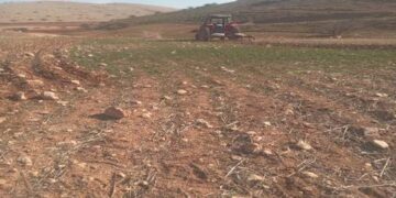
Thursday morning , May 7th 2020 , a group of colonists from “Yakir” colony took over a water spring in Al-Muslaba area west Deir Istiya , and carried on digging the area that surrounds the spring and changing its features , with the intention to turn it into a pool. Noteworthy, the water spring is in a plot belongs Hassan Abu Hajla.
Yakir illegal colony is built on confiscated lands 200 m away from Abu Hajla’s plot, during the last few years the occupation tried over and over to impose control over the spring and the surrounding plot , but people of the area were conscious to the occupation’s schemes, and protected the plot.
Deir Istiya municipality head Sa’id Zidan told LRC the following:
“In 2012, the building and organization high council proposed an outline for the expansion of Yakir colony on confiscated Palestinian lands at Al-Muslaba location; Landowners objected on the outline to the Supreme court, the court refused the outline , which gave hope to the owners to protect 500 dunums at the area from colonial schemes.”
Hassan Abu Hajla told LRC:
“I inherited an olive grove (84 dunums) in Al-Muslaba area which I cultivate all the time , this olive grove provide a source of income for my family of (7 members, 2 of them are children).
Despite continuous colonists assaults and killing threats and the occupation forces assaults, I insist to stay steadfast and protect my ancestors’ lands.”
Abu Hajla asserted:
“May 7th 2020, illegal colonists took advantage of the corona lockdown and the fact that Palestinians can’t get out from their homes to turn a water spring into a pool.”
Yakir colony was built on Wad Qana lands in the 80s of the last century, since its establishment, Yakir colonist have been carrying out frequent volitions that are destructive to the environment, the colony is moreover expanding from its eastern sides, devouring lands previously confiscated under “security claims”.
 The water spring after being turned into a pool
Deir Istiya village: [1]
10 km north Salfit , Deir Istiya is surrounded by Ematin , Jinsafut and Kafr Laqif (north), Azzun and Kafar Thulth (west), Zita, Jama’en and Kafl Haris (east), Haris and Qaraqwat Bani Hyssan (south)
Deir Istiya has a population of (3,696) people in 2017 census. The town has a total area of 34,125, of which 640 dunums are a built up area. The Israeli occupation confiscated (4,257) dunums for the following purposes:
|
Settlement name |
Establishment year |
Area in dunums |
Number of settlers 2018 |
|
Revava |
1991 |
167 |
2,664 |
|
Yakir |
1981 |
757 |
2,341 |
|
Ginat Shomron |
1985 |
944 |
NA |
|
Karnei Shomron |
1978 |
540 |
8,388 |
|
Novim |
1986 |
663 |
867 |
|
Immanuel |
1981 |
879 |
4,220 |
|
Ma’ale Shomron |
1980 |
52 |
1,002 |
|
Al-Matan |
1981 |
22 |
NA |
- Bypass roads 55 and 5066 devoured 118 dunums.
- The segregation wall (1,148 m ate up115 dunums , in case its construction plan was completed it will isolate 8,408 dunums and eat up 160 dunums.
Oslo accords classified Deir Istiya as the following :
- B area : 6,132 dunums.
- C area 27,993 dunums.
[1] GIS-LRC


