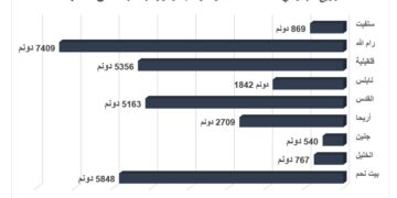
- Violation: colonial expansion.
- Location: Beitillu and Kubar north Ramallah.
- Date: 01/07/2019.
- Perpetrator: “Nahliel” settlement.
Description:
“Nahliel” settlement is expanding on confiscated lands from Ramallah villages , the surrounding lands of Nahliel are going through a vast ravaging operation.
Land research centre field team noticed Israeli bulldozers ravaging about 70 dunums on the four sides of “Nahliel” settlement. Owners of the targeted plots were denied accessing to it years ago under claims that they are an Israeli state property.
The targeted lands are in natural block 1 of “Kubar” in an area known of “Aj-Jahran” and natural block 1 of an area known ok Kafr Soum.
Kubar village council head ‘Izzat Beduan told LRC reporter:
“The plot were Nahliel settlement is built and its surrounding , belong to Palestinian farmers which is proved with Tapu papers , the lands were confiscated and announced as an Israeli state property in1983 , in 1984 a colonization society rented part of those lands to establish a new outpost on the hill , the outpost started to expand and received huge support from the occupation government . Later on , the high organization council – Colonization subcommittee made an organizational plan for the settlement.”
Nahliel:
Nahliel was established in 1984 over lands of Bitillo and al Janya. The colony expanded by the construction of several outposts which were eventually merged to form Nahliel colony which has taken over 100of dunums of Palestinian lands. It also spreads terror around the peaceful country side as 747 of the most radical Jews reside in the colony. The settlement consists of a public library , clinic , post office and 2 synagogues.
 |
 |
 |
 |
 Photos 1-5 : expansion works in the settlement
Photo 5: was taken in Beitillu
Ras Karkar:[1]https://poica.org/2017/06/israel-gives-green-light-to-new-master-plan-for-talmon-b-colony-at-the-expense-of-palestinian-villages/ – _edn1
15 kilometer north west of Ramallah, Ras Karkar is surrounded by Deir ‘Ammar (north), Kafr Ni’ma and Deir Ibziq (south), Al Jania (east), Bani Harth (west).
Ras Karkar has a population of 2450 people according to statistics conducted by the Palestinian Central Bureau of Statistics in 2008. It has a total area of 5050, 330 of which are a built-up area of the village.
The Israeli occupation devoured more than 32 dunums of the lands of the village for Talmon C colony which was built in 1989. Moreover, bypass number ‘463 took over 295 dunums of the village lands.
According to Oslo Accords, 19% of Ras Karkar is under Area B (PA has full civil and security control) while most of the village lands (81%) is under Area C (Israel maintains full security and administrative control). Here are the area in dunums:
- Area B (940) dunums
- Area C (4110) dunums
[1] GIS-LRC
Prepared by


