• About The Project
  • Palestine in Century
  • Selected Maps
  • Glossary
  • About ARIJ
  • About LRC
  • By Year
    • Case Studies By Year
    • Daily Report By Year
Sunday, June 7, 2026
POICA
No Result
View All Result
  • Home
  • Settlements
    • New Israeli Settlements
    • Settlement Expansion
  • Israeli Violations
    • Agriculture
    • Confiscation
    • Demolition
    • Environment
    • Eviction of Palestinians
    • Settlers Attacks
  • Bypass Roads
  • Israeli Plans
  • Segregation
    • Checkpoints
    • Closure
    • Separation Plans
  • Military Orders
  • Reports
    • Daily Report
    • Monthly Report
    • Quarterly Report
No Result
View All Result
POICA
No Result
View All Result

Confiscation order on lands in ‘Azzun / Qalqilya

October 14, 2019
in Military Orders
Confiscation order on lands in ‘Azzun / Qalqilya


  • Violation : Laying hands on 250m2.
  • Location: the northern borders of ‘Azzun/ Qalqilya.
  • Date: 16/07/2019.
  • Perpetrator: The Israeli occupation forces.
  • Victims: People of ‘Azzun.

Description:

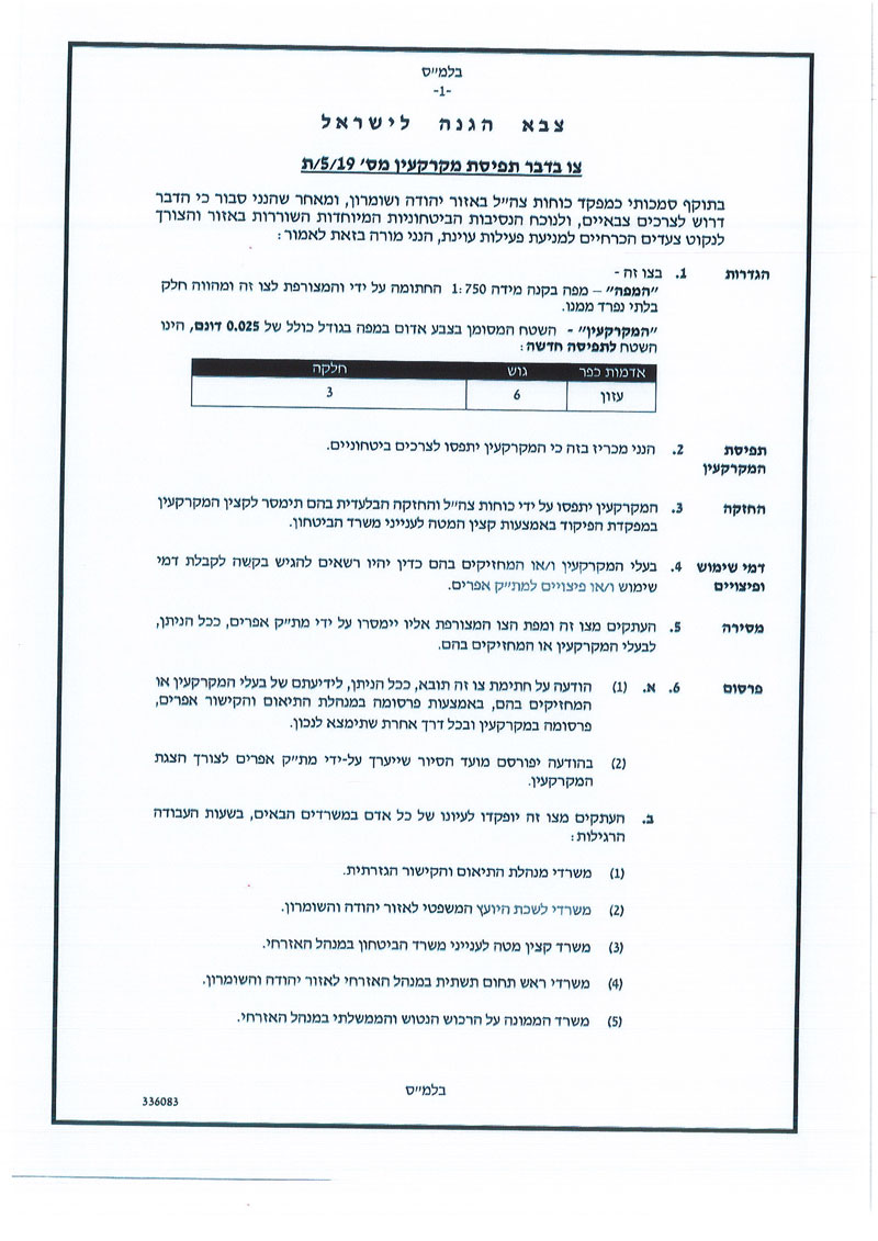
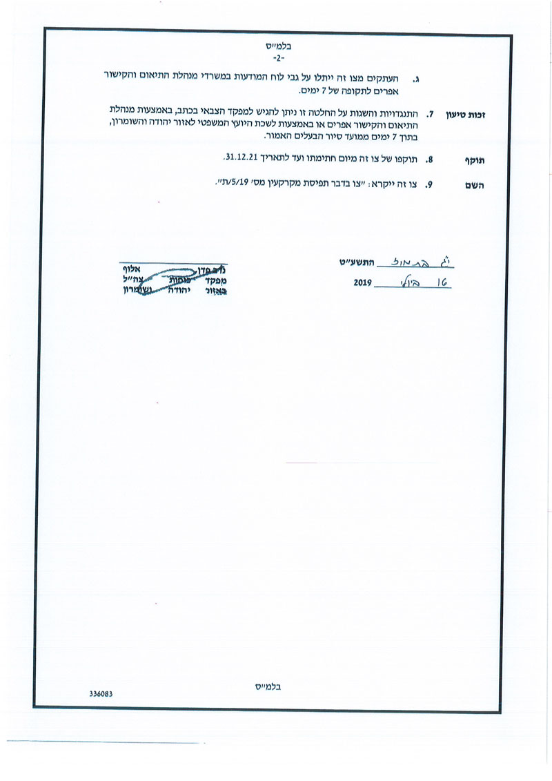
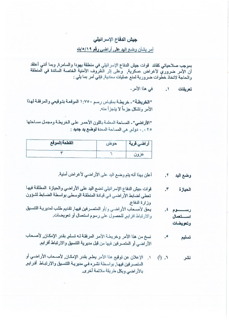
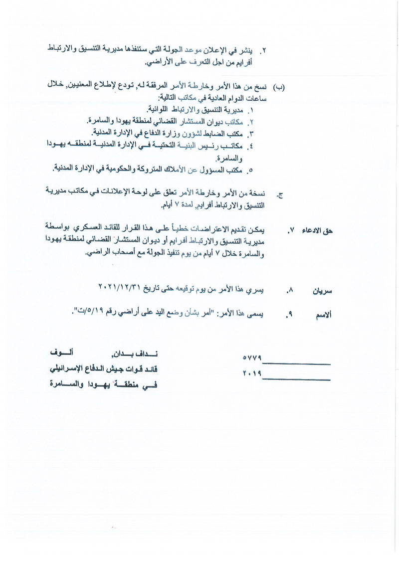
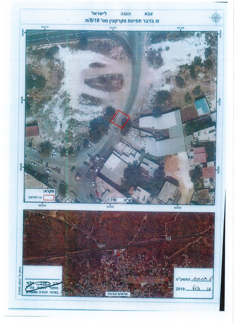
The Israeli occupation’s army commander in West Bank “Nidav Alof” issued military order numbered (19/5/T) which lays hands on 250 m2 of ‘Azzun lands , close to the occupations “security gate” on the northern entrance of ‘Azzun (as shown in the attached map).

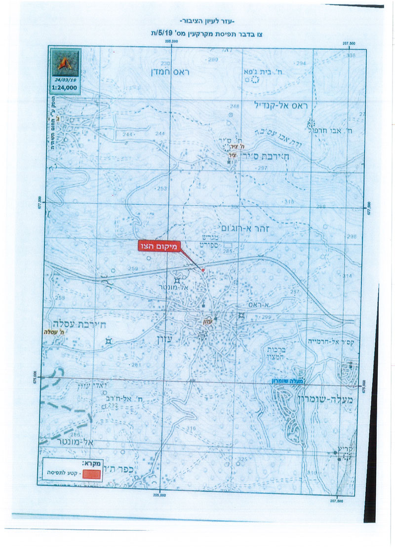
As illustrated in the military order the targeted lands are in natural block 6 piece 3 . The occupation’s commander in west bank claims that the confiscation is for security necessities.

Activist Hassan Shbaita from ‘Azzun told LRC reporter:

“In the recent five years , the occupation escalated attacks against people of ‘Azzun , weekly the gate is closed several times , which isolates the village from its surrounding and tightens citizens’ movement , the situation now repeats itself more often than ever , that was preceded by putting a siege on the northern entrance of the village , there is also a new military order that confiscates several meters close to the military gate, which reflects the occupation’s intention to impose realities on the ground, and impose full control on the northern entrance , that creates a harsh reality that affects the lives of 11,000 people living in the town, it is also expected that they may install a permanent watch point in the area.”

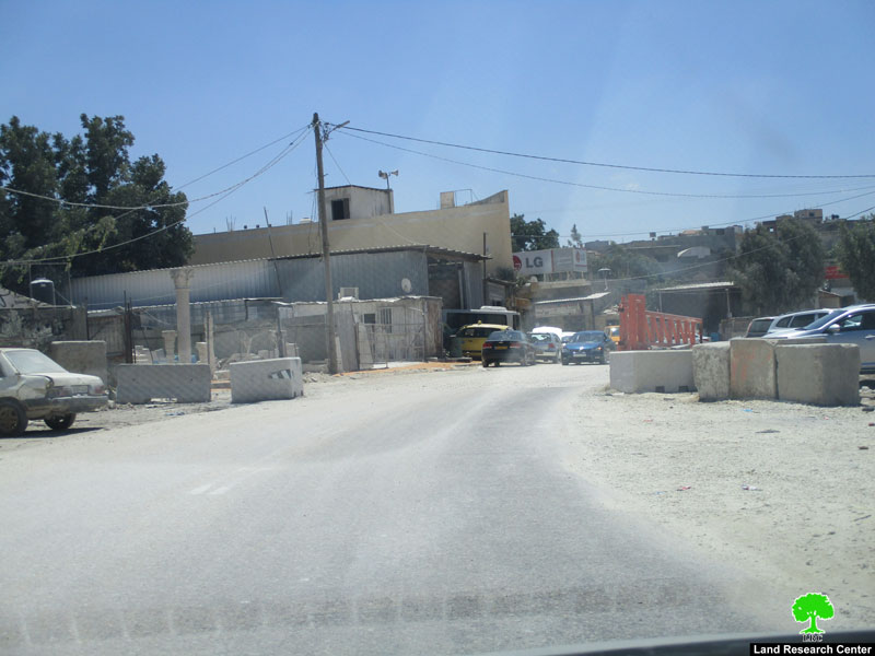
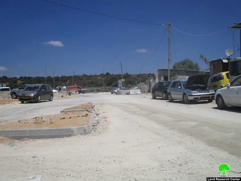
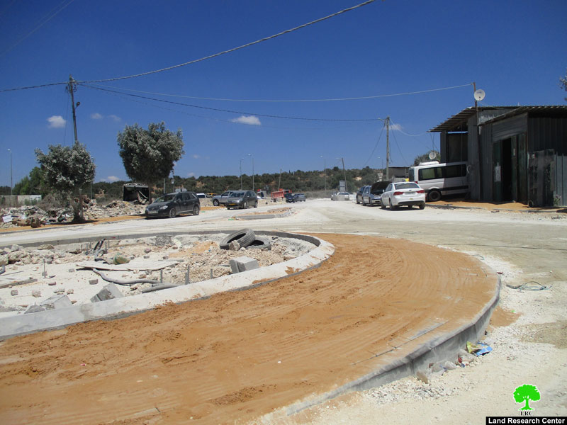
Photos 1-3: the town’s northern borders – the targeted area

Noteworthy, the occupation frequently closes the town’s northern entrance through their “Security gate”,  and tightens the siege around the village.

About Azzun[1]:

Located 8km to Qalqiliya city with a total area of 9,472 dunums, of which 1,054 dunums are the village’s built-up area. The occupation confiscated vast area from the village for the favor of colonization and the apartheid wall; the areas are detailed as follows:

  • 276 dunums were confiscated for Maale Shamron colony that was established in 1980.
  • 417 dunums were confiscated for the bypass road number 55

It should be marked that the vast majority of Azzun lands (6,927 dunums) is classified as area “C” according to Oslo accords; areas that are controlled by the Israeli occupation. The village has zero percentage of area “A” that is under the control of Palestinian Authority. As for other classifications, the village has 2,546 dunums classified as area “B”. (Geographical Information System- Land Research Center)

3 colonies are built on ‘Azzun lands and they are:

  • Maale Shomron: Built in 1980, the colony has a total area of 1903 and a built-up area of 216 dunums. 549 colonists live in it (according to a 2004 census).
  • Genot Shomron: Built in 1985, the colony’s built-up area is 484 dunums.
  • Karni Shomron: Built in 1978, the colony’s built-up area is 1351 dunums. 6270 colonists live in it (according to a 2005 census)


[1] GIS-LRC


Prepared by

 The Land Research Center
LRC

Recommended For You

سلطات الاحتلال الإسرائيلي بصدد الاستيلاء على موقع قبر النبي صموئيل شمال غرب مدينة القدس

by arij
May 23, 2026
0
سلطات الاحتلال الإسرائيلي بصدد الاستيلاء على موقع قبر النبي صموئيل شمال غرب مدينة القدس

 نشرت سلطات الاحتلال الإسرائيلي في الثامن عشر من شهر أيار من العام 2026 اعلانا مفاده الاستيلاء على الأراضي الفلسطينية في قرية النبي صموئيل شمال غرب القدس المحتلة. وجاء...

Read moreDetails

إقامة منطقة عسكرية عسكرية داخل أراضي (أ) في جنين

by arij
May 19, 2026
0
إقامة منطقة عسكرية عسكرية داخل أراضي (أ) في جنين

   في السابع من شهر أيار من العام 2026، وزعت سلطات الاحتلال الإسرائيلي أمرا عسكريا جديدة على أهالي مدينة جنين يقضي بمصادرة 7.2 دونما من الأراضي الفلسطينية في...

Read moreDetails

“بمساحة اجمالية 177 دونما من أرضي البيرة وبيتين”, طريق استيطاني لخدمة البؤر الاستيطانية في محافظة رام الله

by arij
May 18, 2026
0
“بمساحة اجمالية 177 دونما من أرضي البيرة وبيتين”, طريق استيطاني لخدمة البؤر الاستيطانية في محافظة رام الله

في الحادي عشر من شهر أيار من العام 2026, نشرت دائرة أراضي إسرائيل اعلانا جديدا يقضي بمصادرة المزيد من الأراضي الفلسطينية في محافظة رام الله لأغراض استيطانية في...

Read moreDetails

“في خدمة مستوطنة ناحال حيلتس”, طريق استيطاني إسرائيلي جديد على أراضي بتير وبيت جالا في محافظة بيت لحم

by arij
May 18, 2026
0
“في خدمة مستوطنة ناحال حيلتس”, طريق استيطاني إسرائيلي جديد على أراضي بتير وبيت جالا في محافظة بيت لحم

تواصل سلطات الاحتلال الإسرائيلي إحكام سيطرتها على المزيد من الأراضي الفلسطينية في الضفة الغربية المحتلة، وهذه المرة من خلال استهداف أراضي محافظة بيت لحم. ففي السادس والعشرين من...

Read moreDetails

مناطق نفوذ المستوطنات ودورها في إعادة تشكيل الجغرافيا الفلسطينية

by arij
April 23, 2026
0
مناطق نفوذ المستوطنات ودورها في إعادة تشكيل الجغرافيا الفلسطينية

أصدرت سلطات الاحتلال الإسرائيلي في العاشر من شهر نيسان 2026 الكراسة رقم (273)، وهي وثيقة تضم مجموعة من المناشير والأوامر والتعيينات الإسرائيلية المتعلقة بالجوانب الأمنية والعسكرية والإدارية، إضافة...

Read moreDetails
Next Post
Confiscation order on lands in ‘Azzun / Qalqilya

إخطار عسكري  بوضع اليد على أراضي  في بلدة عزون / محافظة قلقيلية

LATEST NEWS

سلطات الاحتلال الإسرائيلي بصدد الاستيلاء على موقع قبر النبي صموئيل شمال غرب مدينة القدس

سلطات الاحتلال الإسرائيلي بصدد الاستيلاء على موقع قبر النبي صموئيل شمال غرب مدينة القدس

by arij
May 23, 2026
0

........................................................

إقامة منطقة عسكرية عسكرية داخل أراضي (أ) في جنين

إقامة منطقة عسكرية عسكرية داخل أراضي (أ) في جنين

by arij
May 19, 2026
0

........................................................

الآثار كأداة للضم الزاحف: مشروع القانون الإسرائيلي لإعادة هندسة الجغرافيا والهوية في الضفة الغربية

الآثار كأداة للضم الزاحف: مشروع القانون الإسرائيلي لإعادة هندسة الجغرافيا والهوية في الضفة الغربية

by arij
May 23, 2026
0

........................................................

النكبة الفلسطينية في ذكراها الثامنة والسبعين: من التطهير العرقي إلى الإبادة وإعادة هندسة الجغرافيا الفلسطينية 

النكبة الفلسطينية في ذكراها الثامنة والسبعين: من التطهير العرقي إلى الإبادة وإعادة هندسة الجغرافيا الفلسطينية 

by arij
May 18, 2026
0

........................................................

flag_yellow_lowEU-PfP-Logo

This website and its content were initiated in 1993 by the Applied Research Institute – Jerusalem (ARIJ) and the Land Research Center (LRC) with the support from the European Union up until 2023. Since then, the Applied Research Institute – Jerusalem (ARIJ) has taken over the continued development and maintenance of the website. The views expressed remain solely those of ARIJ) and do not necessarily reflect those of the European Union.

© 2026 Copyright | ARIJ | All Rights reserved.

No Result
View All Result
  • Home
  • Settlements
    • New Israeli Settlements
    • Settlement Expansion
  • Israeli Violations
    • Agriculture
    • Confiscation
    • Demolition
    • Environment
    • Eviction of Palestinians
    • Settlers Attacks
  • Bypass Roads
  • Israeli Plans
  • Segregation
    • Checkpoints
    • Closure
    • Separation Plans
  • Military Orders
  • Reports
    • Daily Report
    • Monthly Report
    • Quarterly Report

© 2026 Copyright | ARIJ | All Rights reserved.