• About The Project
  • Palestine in Century
  • Selected Maps
  • Glossary
  • About ARIJ
  • About LRC
  • By Year
    • Case Studies By Year
    • Daily Report By Year
Wednesday, October 15, 2025
POICA
No Result
View All Result
  • Home
  • Settlements
    • New Israeli Settlements
    • Settlement Expansion
  • Israeli Violations
    • Agriculture
    • Confiscation
    • Demolition
    • Environment
    • Eviction of Palestinians
    • Settlers Attacks
  • Bypass Roads
  • Israeli Plans
  • Segregation
    • Checkpoints
    • Closure
    • Separation Plans
  • Military Orders
  • Reports
    • Daily Report
    • Monthly Report
    • Quarterly Report
No Result
View All Result
POICA
No Result
View All Result

Eviction order on 17 dunums in Wad Qana

March 17, 2015
in Military Orders
Eviction order on 17 dunums in Wad Qana


Violation:  serving eviction order on lands

Date:  17/03/2015

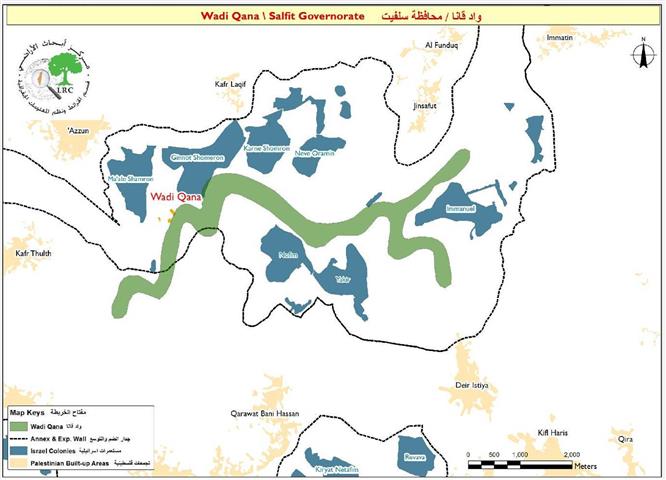
Location:  Wad Qana/ Salfit governorate

Perpetrators: Israel National Parks and Reserves authority

Victims:  three agricultural families form Deir Istiya

Details:

The area of Wad Qana, northeast Salfit governorate is witnessing a new wave of systematic Judaizing plans undertaken by the Israeli occupation to achieve a full takeover on it through controlling all the natural resources and building new colonies.

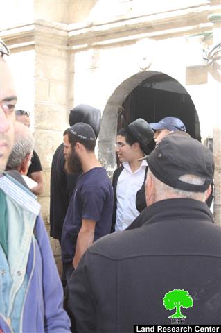
A massive force from the Israeli occupation army accompanied with the so-called Israel National Parks and Reserves Authority on March 17, 2015 raided the area of Ein al-Tanour from the eastern side of Wad Qana and delivered an eviction order on lands (23 dunums) owned by farmers from the area. The order compelled eviction within a period of 72 hours and to restore the original status of the lands;  this notice came under the pretext of the area being a natural reserve. It should be marked that the notified lands are located nearby Karne Shomron.


Photos 1-3: the agricultural lands in Wad Qana


Photos 6-8: the eviction orders on the lands of Mansour and Zaydan families


The mayor of Deir Istiya Amal Koukash told an observer from Land Research Center the following: " the targeted area and lands are owned by a number of farmers from the village; they cultivate them ,plow them seasonally and have ownership documents for them. As usual, the occupation never acknowledge such documents and claim lands as "natural reserves" to take them over and use them later on to expand colonies on. This is exactly what happens today on the lands of Wad Qana and the clue is seen in the expansion on Karne Shomron and Emmanuel colonies". The following table lists information about the affected families:

Affected citizen

Family

Notified plotdunum

Nature of plot

Hasan Mansour

9

4

Planted with citrus and olive trees

Mohammad Zaydan

7

8

Planted with olive trees

Ahmad Mansour

7

11

Planted with citrus and olive trees

TOTAL

23

23


Acoording to the field observation conducted by  Land Research Center , the area of Wad Qana has lately witnessed systematic targeting that was described as taking place on weekly basis. Attacks reached out lands, trees and even humans; assaults on farmers are undertaken for the sake of stopping them from planting their lands.

It should be marked that the area of Wad Qana (10,000 dunums)  accommodates seven Israeli colonies and two outpost, which are all considered an imminent threat on nature and environment and a destructing factor on the agriculture sector.

 About Wad Qana:

It is located in the northwest part of Deir Istiya and surrounded by: Jinsafut, Kfar Laqif and Azzun from the east, Sinrya and Kfar Thulth form the west, Qarawat Bani Hassan from the south, and Amatin and Deir Istya from the east.  Most of Wadi Qana lands are owned by farmers from Deir Istiya. The valley overlooks "Yaker" colony  from the southern side and near to is "Nofem" colony. From the north side, there are three colonies surrounding the valley and they are: "Karni Shamron", "Jannat Shamron", and "Maa'ni Shamron".

Wadi Qana is relative to the village of Deir Istiya ( 34,129 dunums) and has a total land area of 10,000 dunums, of which 13 dunums are the built-up area  and 11 water springs. Worth mentioning, the place is planted with citrus, olives, and field crops.

The area is a natural slope that is located between two mountains and is famous for water abundance and soil fertility. The lands of Deir Istiya are classified, according to Oslo accords as follows: 

  • Area B: it totals around 6132 dunums (18% of the village's total area)
  • Area C : it totals around 27997 dunums (82% of the village's total area)
  • Noteworthy, Wad Qana lands are all classified as area C.


Prepared by
 The Land Research Center
LRC
 

Recommended For You

ما يزيد عن 1900 دونما من الأراضي الفلسطينية في بيت لحم مهددة بالعزل لصالح مستوطنة افراتا

by arij
October 8, 2025
0
ما يزيد عن 1900 دونما من الأراضي الفلسطينية في بيت لحم مهددة بالعزل لصالح مستوطنة افراتا

في الثاني من شهر تشرين أول من العام 2025، أصدرت سلطات الاحتلال الإسرائيلي أمرًا عسكريًا جديدًا يحمل الرقم (ت/3/25) تحت عنوان "تعديل حدود – يهودا والسامرة، 5785-2025". ويأتي...

Read moreDetails

سلطات الاحتلال الإسرائيلي تستغل ‘المنفعة العامة’ لنهب الموارد الفلسطينية

by arij
September 30, 2025
0
سلطات الاحتلال الإسرائيلي تستغل ‘المنفعة العامة’ لنهب الموارد الفلسطينية

في الاول من شهر ايلول من العام 2025، نشرت الإدارة المدنية الإسرائيلية، الذراع الأيمن لحكومة الاحتلال الإسرائيلي أمرا عسكريا جديدا تحت عنوان " أمر ءبشأن قانون الأراضي (الاستملاك...

Read moreDetails

The Occupation Targets the Village of Raba Southeast of Jenin with Military Orders and Seizes Vast Areas of Its Lands

by arij
September 13, 2025
0
الاحتلال يستهدف بأوامر عسكرية قرية رابا جنوب شرق جنين ويصادر مساحات واسعة من أراضيها

 The Israeli occupation Army have continued their policy of plundering Palestinian lands, as their bulldozers leveled wide areas of agricultural land in the village of Raba, southeast of...

Read moreDetails

الاحتلال يستهدف بأوامر عسكرية قرية رابا جنوب شرق جنين ويصادر مساحات واسعة من أراضيها

by arij
September 13, 2025
0
الاحتلال يستهدف بأوامر عسكرية قرية رابا جنوب شرق جنين ويصادر مساحات واسعة من أراضيها

  واصلت قوات الاحتلال الإسرائيلي سياسة نهب الأراضي الفلسطينية، حيث أقدمت آلياتها على تجريف أراض زراعية واسعة في قرية رابا جنوب شرق محافظة جنين، تمهيدا لشق شارع عسكري...

Read moreDetails

Nablus Governorate’s Archaeological Sites Face Israeli Expropriation Plans

by arij
September 11, 2025
0
” المواقع الأثرية في محافظة نابلس… ساحة مفتوحة أمام مخططات المصادرة الإسرائيلية “

On 10 August, 2025, the Israeli Civil Administration (ICA), issued a booklet of military orders signed by the head of the so-called ‘Israeli Civil Administration’ in the occupied...

Read moreDetails
Next Post
جمعيات استيطانية تحاول السيطرة على عقار لعائلة صب لبن في البلدة القديمة

جمعيات استيطانية تحاول السيطرة على عقار لعائلة صب لبن في البلدة القديمة

LATEST NEWS

Annexation of the Jordan Valley: Implications for the Two-State Solution and Regional Stability

الرئاسة الثانية لترامب: فرصة متجددة لطموحات إسرائيل التوسعية – ضم غور الأردن والتداعيات على حل الدولتين واستقرار المنطقة

by arij
October 14, 2025
0

........................................................

محافظة أريحا على خريطة المصادرة الإسرائيلية- إسرائيل تسعى للاستحواذ على أكثر من 7000 دونم في منطقة النبي موسى

محافظة أريحا على خريطة المصادرة الإسرائيلية- إسرائيل تسعى للاستحواذ على أكثر من 7000 دونم في منطقة النبي موسى

by arij
October 13, 2025
0

........................................................

ما يزيد عن 1900 دونما من الأراضي الفلسطينية في بيت لحم مهددة بالعزل لصالح مستوطنة افراتا

ما يزيد عن 1900 دونما من الأراضي الفلسطينية في بيت لحم مهددة بالعزل لصالح مستوطنة افراتا

by arij
October 8, 2025
0

........................................................

Annexation of the Jordan Valley: Implications for the Two-State Solution and Regional Stability

Annexation of the Jordan Valley: Implications for the Two-State Solution and Regional Stability

by arij
September 29, 2025
0

........................................................

flag_yellow_lowEU-PfP-Logo

This website and its content were initiated in 1993 by the Applied Research Institute – Jerusalem (ARIJ) and the Land Research Center (LRC) with the support from the European Union up until 2023. Since then, the Applied Research Institute – Jerusalem (ARIJ) has taken over the continued development and maintenance of the website. The views expressed remain solely those of ARIJ) and do not necessarily reflect those of the European Union.

© 2025 Copyright ARIJ . All Rights reserved. .

No Result
View All Result
  • Home
  • Settlements
    • New Israeli Settlements
    • Settlement Expansion
  • Israeli Violations
    • Agriculture
    • Confiscation
    • Demolition
    • Environment
    • Eviction of Palestinians
    • Settlers Attacks
  • Bypass Roads
  • Israeli Plans
  • Segregation
    • Checkpoints
    • Closure
    • Separation Plans
  • Military Orders
  • Reports
    • Daily Report
    • Monthly Report
    • Quarterly Report

© 2025 Copyright ARIJ . All Rights reserved. .