• About The Project
  • Palestine in Century
  • Selected Maps
  • Glossary
  • About ARIJ
  • About LRC
  • By Year
    • Case Studies By Year
    • Daily Report By Year
Saturday, June 6, 2026
POICA
No Result
View All Result
  • Home
  • Settlements
    • New Israeli Settlements
    • Settlement Expansion
  • Israeli Violations
    • Agriculture
    • Confiscation
    • Demolition
    • Environment
    • Eviction of Palestinians
    • Settlers Attacks
  • Bypass Roads
  • Israeli Plans
  • Segregation
    • Checkpoints
    • Closure
    • Separation Plans
  • Military Orders
  • Reports
    • Daily Report
    • Monthly Report
    • Quarterly Report
No Result
View All Result
POICA
No Result
View All Result

Stop-work orders in the Yatta hamlet of Um Al-Kheir

March 25, 2016
in Military Orders
Stop-work orders in the Yatta hamlet of Um Al-Kheir


  • Violation: serving stop-work orders
  • Location:  Khirbet Um Al-Kheir- Yatta town
  • Date: March 24, 2016
  • Perpetrators: Israeli Occupation Forces and Civil Administration
  • Victims:  citizens Bilal and Halima Al-Hadhaleen

Details:

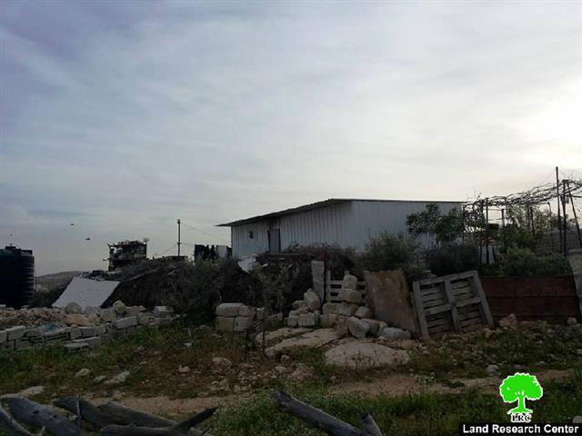
Israeli occupation authorities served on March 24, 2016 stop-work orders on two residences in Um Al-Kheir hamlet, southeast Yatta town in Hebron governorate.

Citizen Bilal said that the so-called Israel Civil Administration and an army patrol raided the hamlet, hung the orders on his residence and a neighbor's house and took some photos of the targeted houses before the force had left.

The orders mentioned that the structures were "unlicensed" and ordered a halt on construction works. April 18, 2016 was assigned as the hearing session of the Inspection Sub-Committee in the Israeli court of Beit El colony to consider the status of the notified structure.

It should be marked that the targeted metal slaps houses were donated by ACF organization  in 2015 to shelter the families, who got their houses demolished for the second time on October 17, 2015. For further information, please read the report issued by Land Research Center in that regard (Link). The following table shows information on the affected people and properties :

No.

Name

Family

Aream2

Order

Photo

1

Bilal Al-Hadhaleen

3

50

180555

1

2

Halima AL-Hadhaleen

9

50

180556

2

Total

12

100


Source : Field observation- Department of Monitoring Israeli Violations- Land Research Center-2016


It should be marked that the hamlet of Um AL-Kheir  that is inhabited by AL-Hadhaleen family  is located nearby Karmel colony, which is founded on confiscated lands from the hamlet. The Israeli occupation has been working hard to displace people through serving demolition and stop-work orders on the residences and their properties.


Prepared by
 The Land Research Center
LRC
 

Recommended For You

سلطات الاحتلال الإسرائيلي بصدد الاستيلاء على موقع قبر النبي صموئيل شمال غرب مدينة القدس

by arij
May 23, 2026
0
سلطات الاحتلال الإسرائيلي بصدد الاستيلاء على موقع قبر النبي صموئيل شمال غرب مدينة القدس

 نشرت سلطات الاحتلال الإسرائيلي في الثامن عشر من شهر أيار من العام 2026 اعلانا مفاده الاستيلاء على الأراضي الفلسطينية في قرية النبي صموئيل شمال غرب القدس المحتلة. وجاء...

Read moreDetails

إقامة منطقة عسكرية عسكرية داخل أراضي (أ) في جنين

by arij
May 19, 2026
0
إقامة منطقة عسكرية عسكرية داخل أراضي (أ) في جنين

   في السابع من شهر أيار من العام 2026، وزعت سلطات الاحتلال الإسرائيلي أمرا عسكريا جديدة على أهالي مدينة جنين يقضي بمصادرة 7.2 دونما من الأراضي الفلسطينية في...

Read moreDetails

“بمساحة اجمالية 177 دونما من أرضي البيرة وبيتين”, طريق استيطاني لخدمة البؤر الاستيطانية في محافظة رام الله

by arij
May 18, 2026
0
“بمساحة اجمالية 177 دونما من أرضي البيرة وبيتين”, طريق استيطاني لخدمة البؤر الاستيطانية في محافظة رام الله

في الحادي عشر من شهر أيار من العام 2026, نشرت دائرة أراضي إسرائيل اعلانا جديدا يقضي بمصادرة المزيد من الأراضي الفلسطينية في محافظة رام الله لأغراض استيطانية في...

Read moreDetails

“في خدمة مستوطنة ناحال حيلتس”, طريق استيطاني إسرائيلي جديد على أراضي بتير وبيت جالا في محافظة بيت لحم

by arij
May 18, 2026
0
“في خدمة مستوطنة ناحال حيلتس”, طريق استيطاني إسرائيلي جديد على أراضي بتير وبيت جالا في محافظة بيت لحم

تواصل سلطات الاحتلال الإسرائيلي إحكام سيطرتها على المزيد من الأراضي الفلسطينية في الضفة الغربية المحتلة، وهذه المرة من خلال استهداف أراضي محافظة بيت لحم. ففي السادس والعشرين من...

Read moreDetails

مناطق نفوذ المستوطنات ودورها في إعادة تشكيل الجغرافيا الفلسطينية

by arij
April 23, 2026
0
مناطق نفوذ المستوطنات ودورها في إعادة تشكيل الجغرافيا الفلسطينية

أصدرت سلطات الاحتلال الإسرائيلي في العاشر من شهر نيسان 2026 الكراسة رقم (273)، وهي وثيقة تضم مجموعة من المناشير والأوامر والتعيينات الإسرائيلية المتعلقة بالجوانب الأمنية والعسكرية والإدارية، إضافة...

Read moreDetails
Next Post

ARIJ Daily Report - Sat, 26th 03 2016

LATEST NEWS

سلطات الاحتلال الإسرائيلي بصدد الاستيلاء على موقع قبر النبي صموئيل شمال غرب مدينة القدس

سلطات الاحتلال الإسرائيلي بصدد الاستيلاء على موقع قبر النبي صموئيل شمال غرب مدينة القدس

by arij
May 23, 2026
0

........................................................

إقامة منطقة عسكرية عسكرية داخل أراضي (أ) في جنين

إقامة منطقة عسكرية عسكرية داخل أراضي (أ) في جنين

by arij
May 19, 2026
0

........................................................

الآثار كأداة للضم الزاحف: مشروع القانون الإسرائيلي لإعادة هندسة الجغرافيا والهوية في الضفة الغربية

الآثار كأداة للضم الزاحف: مشروع القانون الإسرائيلي لإعادة هندسة الجغرافيا والهوية في الضفة الغربية

by arij
May 23, 2026
0

........................................................

النكبة الفلسطينية في ذكراها الثامنة والسبعين: من التطهير العرقي إلى الإبادة وإعادة هندسة الجغرافيا الفلسطينية 

النكبة الفلسطينية في ذكراها الثامنة والسبعين: من التطهير العرقي إلى الإبادة وإعادة هندسة الجغرافيا الفلسطينية 

by arij
May 18, 2026
0

........................................................

flag_yellow_lowEU-PfP-Logo

This website and its content were initiated in 1993 by the Applied Research Institute – Jerusalem (ARIJ) and the Land Research Center (LRC) with the support from the European Union up until 2023. Since then, the Applied Research Institute – Jerusalem (ARIJ) has taken over the continued development and maintenance of the website. The views expressed remain solely those of ARIJ) and do not necessarily reflect those of the European Union.

© 2026 Copyright | ARIJ | All Rights reserved.

No Result
View All Result
  • Home
  • Settlements
    • New Israeli Settlements
    • Settlement Expansion
  • Israeli Violations
    • Agriculture
    • Confiscation
    • Demolition
    • Environment
    • Eviction of Palestinians
    • Settlers Attacks
  • Bypass Roads
  • Israeli Plans
  • Segregation
    • Checkpoints
    • Closure
    • Separation Plans
  • Military Orders
  • Reports
    • Daily Report
    • Monthly Report
    • Quarterly Report

© 2026 Copyright | ARIJ | All Rights reserved.