The Israeli colonial enterprise has always held two goals hand in hand: expansion and separation. Though Israeli expansionism has continued unabated during the Aqsa Intifada, the Palestinian resistance has called into serious question Israeli efforts to separate themselves from the Palestinian population. The Israeli version of apartheid has not succeeded in granting Israelis a privileged serene life while their Palestinian neighbors continue to live under oppressive military occupation in the West Bank and Gaza or refugee camps in other Arab countries. Nevertheless, after a number of attacks in Israel, the Israeli government is re-examining the previously suggested strategy of unilateral separation between Israel proper and the West Bank. The recently proposed plan to create a security zone along the east side of the 1949 Armistice Line (Green Line) reveals how the Israeli government continues to mistakenly believe it can deny justice to the Palestinian people and at the same time maintain a life-style for Israelis that resembles a society at peace with its neighbors. It also demonstrates how the twin goals of separation and expansion are often held in tension.
Plans for unilateral separation between Israel proper and the West Bank have been raised before. In December 2000, Ex-Deputy Defense Minister Efraim Sneh proposed a plan under the premiership of Benjamin Netanyahu but the plan went nowhere because of the following change in government. Sneh's plan involved a 74-kilometer long security fence of cement walls, iron rails, and concrete blocks. Most recently, on June 5, 2000, Israeli MK Roman Bronfman of the Democratic Choice party proposed a similar plan (Jerusalem Post June 3, 2001).
But such plans are full of political controversy within Israel. The political right vehemently opposes them because such attempts at separation clash squarely with the goal of expansion into as much of the West Bank as possible. Israel is the only country in the world that does not officially declare its borders, thus leaving open-ended the territorial extent of its colonial enterprise. For rightists a security fence along the 1949 Armistice line would come too close to establishing fixed borders, isolating many settlements or even requiring the removal of some of them. It may also fence off land Israel intends to lay claim to in the Jordan Valley, among other places. Other members of the Israeli government object mainly on practical grounds, claiming that, given the present demographic realities, it is impossible to construct a barrier that effectively separates Israel and the settlements from the Palestinian population.
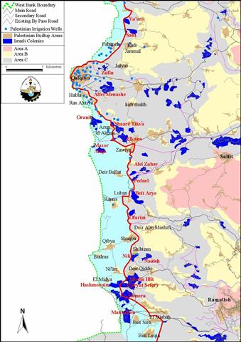
But most of the high-profile talks currently taking place in the Israeli government do not include a border-like fence, which both Prime Minister Sharon and Foreign Minister Peres object to. The proposed alternative is a 3-8 kilometer closed military zone along the east of the 1949 Armistice Line, to the north of Jerusalem; see map 1. Such a plan would include the closing or destruction of most of the roads in this 'buffer zone', a massive increase in the military presence there, and heavy surveillance of the Palestinian population. The Israeli Army would control this area east of the armistice line while the Israeli police will monitor the area on its western side, where the Army does not have a mandate to operate. Steps have already been taken to establish the military zone. The Army has already begun operating a brigade headquarters in the Zufin military camp east of Qalqilya. The new brigade assigned to the area will be called the ''seamline brigade''. The headquarters has thus far been allotted two companies from the Golan Heights, special units from the Armor Corps commando, and several dozen military police (Haaretz, June 7, 2001).. Such a plan would include the closing or destruction of most of the roads in this 'buffer zone', a massive increase in the military presence there, and heavy surveillance of the Palestinian population. The Israeli Army would control this area east of the armistice line while the Israeli police will monitor the area on its western side, where the Army does not have a mandate to operate. Steps have already been taken to establish the military zone. The Army has already begun operating a brigade headquarters in the Zufin military camp east of Qalqilya. The new brigade assigned to the area will be called the ''seamline brigade''. The headquarters has thus far been allotted two companies from the Golan Heights, special units from the Armor Corps commando, and several dozen military police (, June 7, 2001).
This massive military presence will have grave repercussions for the Palestinian people, in particular those who live in villages that will be abosorbed into the military zone (the blue area in the map). The proposed security area (stretching to some 140 square kilometers) will include at least 20 Palestinian villages of which 14 are within Area B (the area that is supposedly under joint Palestinian Israeli control). The total population of those villages is around 40,000 people and they work mainly in agriculture. These Palestinians will find their freedom of movement severely restricted. Those farmers in the area who will be able to reach their fields may be permitted to work them during the day. But they and all other Palestinians will be required to remain closed up in their villages after dark or any other time the Israeli forces choose to confine them.
Table of Palestinian localities incorporated into the Israeli-proposed security zone
|
Locality Name |
Population |
Location |
|
'Arab ar Ramadin ash Shamali |
51 |
Area C |
|
'Izbat Salman |
457 |
Area C |
|
A'zoun El A'tma |
1187 |
Area B |
|
Beit Leqia |
5709 |
Area B |
|
Beit Sira |
2010 |
Area B |
|
Budrus |
1070 |
Area B |
|
Deir Ballut |
2680 |
Area B |
|
El-Midya |
923 |
Area B |
|
Falame |
502 |
Area C |
|
Habla |
4371 |
Area B |
|
Khirbet Jabara |
244 |
Area C |
|
Khirbet Ras A'tiya |
1136 |
Area B |
|
Khirbet El Misbah |
3711 |
Area B |
|
Mahattat Tahseen Mansur |
19 |
Area C |
|
Marj A'malyra(Beit Nuba) |
207 |
Area C |
|
Ni'lin |
3361 |
Area B |
|
Qibya |
3487 |
Area B |
|
Rantis |
2047 |
Area B |
|
Shuqba |
3067 |
Area B |
|
Zawiya |
3695 |
Area B |
|
Total |
39934 |
14 in Area B |
Moreover, the proposed security area encompasses some 23 Palestinian irrigation wells that supply around 2,147,100 cubic meters of water every year. Hence, one can conceive that the Israeli plan is to tap into that vital source and deprive the Palestinians of their basic means of survival. Surely the attempt is to strangulate the Palestinians into submission.
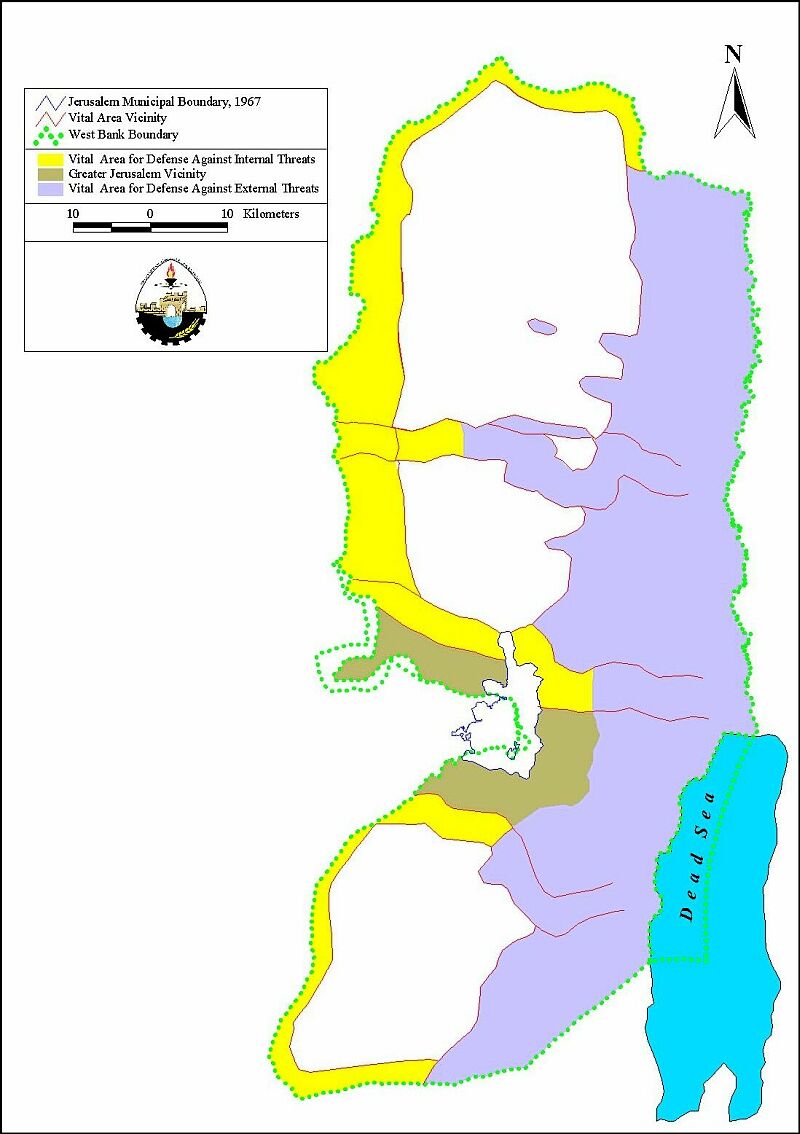
Israelis continue to debate proposals of unilateral separation. Much of the public argument for establishing a buffer zone east of the armistice line is to provide for the security of Israel. But in essence the debate within the Israeli government is about how to best colonize the West Bank. Though not all in the Israeli government will be pleased with the proposed military zone, it will attempt to satisfy both the goal of seperation and of expansion. That the military zone will attempt to separate West Bank Palestinians from Israel proper is obvious. It is also apparent that the military zone will establish a stronger hold on an area the Israelis have longed hoped would be annexed to Israel, thus serving Israel's expansion. Almost all Israeli plans for future borders include the fertile area east of the armistice line. A plan developed by now Prime Minister Ariel Sharon in 1997 is no different; see map 2. The establishement of the military zone will amount to yet one more step in a list of many over the years to secure control of the area.. The establishement of the military zone will amount to yet one more step in a list of many over the years to secure control of the area.
Prepared by:
The Applied Research Institute – Jerusalem


