• About The Project
  • Palestine in Century
  • Selected Maps
  • Glossary
  • About ARIJ
  • About LRC
  • By Year
    • Case Studies By Year
    • Daily Report By Year
Friday, October 3, 2025
POICA
No Result
View All Result
  • Home
  • Settlements
    • New Israeli Settlements
    • Settlement Expansion
  • Israeli Violations
    • Agriculture
    • Confiscation
    • Demolition
    • Environment
    • Eviction of Palestinians
    • Settlers Attacks
  • Bypass Roads
  • Israeli Plans
  • Segregation
    • Checkpoints
    • Closure
    • Separation Plans
  • Military Orders
  • Reports
    • Daily Report
    • Monthly Report
    • Quarterly Report
No Result
View All Result
POICA
No Result
View All Result

The Enlargement of the Bet El Checkpoint Connecting Beiten and Ramallah

March 7, 2012
in Checkpoints
The Enlargement of the Bet El Checkpoint Connecting Beiten and Ramallah
 Violation: Israeli occupation forces continue the closure of the southern and western entrances of the village of Beiten while enlarging the Bet El military checkpoint.
Location: The village of Beitin.
Date: The month of March, 2012.
 
Details:
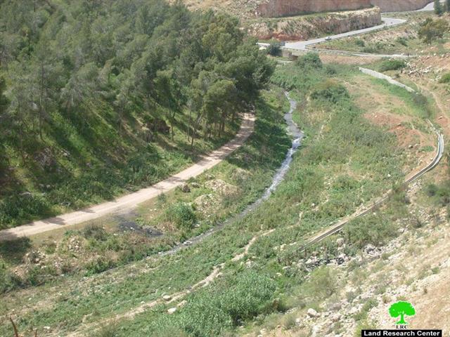
Israeli occupation forces have been blocking both the suture and western entrances to the village of Beitin for the 11th consecutive years; in the year 2001, these forces closed the main entrance of the village that links the village to the main by-pass Road 60 as a collective punishment. They have also blocked the southern entrance which links the village to the City of Al Bireh which largely affected negatively the lives of more than 2,500 Palestinians living in the village. By so doing, the three-kilometer distance that separates between Beitin and Al Bireh became an 18-kilomter detour that the residents must use in order for them to reach their workstations in Ramallah; Now, the residents have to leave Beitin towards the village of Ein Yabroud, then the village of Dura Al Qara’a, Al Jalazoun Refugee Camp, the village of Surda, the village of Abu Qash then the City of Ramallah. This trip causes both financial and time losses on daily basis to the residents of Beitin in their efforts to provide a decent life to their families and loved ones.
 
Pic.1: The closed western entrance of the village of Beitin
 
From his part, Mr. Diab Yaseen, the Head of the Beitin’s Village Council, expressed the following to the Land Research Center (LRC)’s field researcher:  There are a number of legal cases filed with the Israeli High Court the last of which was filed in October 2011 asking to open the southern entrance. Yet, the Court is dragging its feet on this issue as it basis its reluctance on the “security reason” presented to it by the occupation forces providing protection for the colonists of Bet El. This has led to an increase of poverty in the village and the reduction of its livelihood standards.
 
It has to be mentioned that the southern entrance of Beitin has been opened since the days of the British Mandate which makes it a historical sign of the village that cannot be changed in accordance with the International Law and the Geneva Conventions. Yet, realities on the ground prove that the High Court is nothing but a tool in the hands of the occupation forces and the colonists.
 
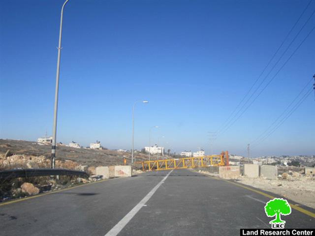
Enlargement of Bet El Checkpoint:
Not only did the occupation forces continue to close the two entrances of the village, they have already started to enlarge the Bet El checkpoint located on lands of the village of Beitin. This checkpoint connects between the so-called “Civil Administration” and the city of Al Bireh. The checkpoint is manned 24-7 and they close it down between 10 PM and 7 AM.
 
Pic.2: Bet El military checkpoint.
The enlargement works included the addition of extra lanes leading to the checkpoint and additional military observation towers, leading to the belief that the occupation forces have the intention to continue keeping the physical obstacles in the face of Palestinians and their free movement.
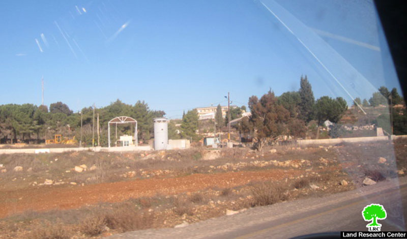
 
Beitin Village:
It is located 3 kilometers north of the city of Al Bireh. Its area is about 5400 dunums of which 1,200 dunums are its built-up area. Its population is estimated to be 2,300. More than 1,600 dunums of its lands were confiscated for the purpose of establishing the colony of Bet El. The further expansion of the colony throughout the years caused numerous problems for the Palestinians of Beitin and others in surrounding villages.
 
Pic.3: The colony of Bet El.  
Prepared by
The Land Research Center
LRC

Recommended For You

عقاب جماعي يومي: الفلسطينيون تحت هيمنة الحواجز العسكرية

by arij
September 24, 2025
0
عقاب جماعي يومي: الفلسطينيون تحت هيمنة الحواجز العسكرية

تشهد الضفة الغربية المحتلة واقعًا خانقًا نتيجة السياسات الإسرائيلية المتمثلة بفرض المزيد من الحواجز العسكرية اليومية والإغلاقات، والتي باتت أداة منهجية للسيطرة والتحكم بحياة الفلسطينيين اليومية، وليست مجرد...

Read moreDetails

الحرب على قطاع غزة وتأثيرها على محافظة الخليل جنوب الضفة الغربية

by arij
November 30, 2023
0

  تقع محافظة الخليل في الجزء الجنوبي من الضفة الغربية المحتلة، إلى الجنوب من مدينة القدس، وعلى بعد حوالي 36 كم منها. يحدها من الشمال محافظة بيت لحم،...

Read moreDetails

تطبيق سياسة الفصل العنصري على استخدام الطرق الرئيسية في الضفة الغربية وتقيد حركة وتنقل المواطنين الفلسطينيين

by arij
November 22, 2023
0
معاناة شجرة الزيتون الفلسطينية بسبب الاحتلال والاستيطان في العام 2023

  بناء على تقديرات مراقبين دوليين يبلغ عدد الحواجز الإسرائيلية في الضفة الغربية أكثر من 567 حاجز إسرائيلي متعددة الاشكال منها 77 حاجزًا رئيسيًا وجزئي تتحكم في حركة...

Read moreDetails

The Instigation of Apartheid Roads Era: Israel blocks Palestinian movement inside West Bank Governorates

by arij
November 22, 2023
0

  According to international observers, Israel constrains the West Bank territory with 567 various types of obstacles; 77 of which are main checkpoints and partial checkpoints that control...

Read moreDetails

Between “Ben Gavir” and Netanyahu Not Oblivious but Vindictive, The reality of Israeli Apartheid Stands in the occupied Palestinian territory

by arij
September 13, 2023
0
Between “Ben Gavir” and Netanyahu Not Oblivious but Vindictive, The reality of Israeli Apartheid Stands in the occupied Palestinian territory

  In the wake of the overwhelming Israeli settlers and the Israeli occupation government increasing their wave of attacks and assaults on the Palestinian people (more than 700...

Read moreDetails
Next Post
The Colony of Rafafa: The Source of Pollution in Wadi Qana

The Colony of Rafafa: The Source of Pollution in Wadi Qana

LATEST NEWS

Annexation of the Jordan Valley: Implications for the Two-State Solution and Regional Stability

Annexation of the Jordan Valley: Implications for the Two-State Solution and Regional Stability

by arij
September 29, 2025
0

........................................................

Isolation of Three Villages Northwest of Jerusalem: Silent Annexation Creeps toward the Capital

عزل ثلاث قرى فلسطينية شمال غرب مدينة القدس: الضم الاسرائيلي الصامت يزحف نحو محيط العاصمة

by arij
September 24, 2025
0

........................................................

Isolation of Three Villages Northwest of Jerusalem: Silent Annexation Creeps toward the Capital

Isolation of Three Villages Northwest of Jerusalem: Silent Annexation Creeps toward the Capital

by arij
September 24, 2025
0

........................................................

سياسات التهويد في القدس: من السيطرة المكانية إلى طمس الهوية عبر التسمية

سياسات التهويد في القدس: من السيطرة المكانية إلى طمس الهوية عبر التسمية

by arij
September 23, 2025
0

........................................................

flag_yellow_lowEU-PfP-Logo

This website and its content were initiated in 1993 by the Applied Research Institute – Jerusalem (ARIJ) and the Land Research Center (LRC) with the support from the European Union up until 2023. Since then, the Applied Research Institute – Jerusalem (ARIJ) has taken over the continued development and maintenance of the website. The views expressed remain solely those of ARIJ) and do not necessarily reflect those of the European Union.

© 2025 Copyright ARIJ . All Rights reserved. .

No Result
View All Result
  • Home
  • Settlements
    • New Israeli Settlements
    • Settlement Expansion
  • Israeli Violations
    • Agriculture
    • Confiscation
    • Demolition
    • Environment
    • Eviction of Palestinians
    • Settlers Attacks
  • Bypass Roads
  • Israeli Plans
  • Segregation
    • Checkpoints
    • Closure
    • Separation Plans
  • Military Orders
  • Reports
    • Daily Report
    • Monthly Report
    • Quarterly Report

© 2025 Copyright ARIJ . All Rights reserved. .