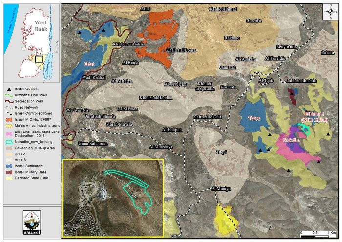
The higher planning council of the Israeli Civil Administration in the occupied West Bank has deposited a new plan for building in the East Gush Etzion settlement of Nokdim east of Bethlehem city. The land to the north of Nekodim settlement is set to receive a new construction that will cause the confiscation of almost 49 dunums of land of Arab At Ta’amreh east of Bethlehem city. The plan holds number יוש/ 1/ 4/ 6/ 411 and stipulates the building of new public facilities and roads to the north of Nokdim settlement, further expanding the borders of the settlement to include this new construction. Construction is to take place in Parcel No. 4 of Al Ka’abneh and Waer Abu Muhareb sites in Arab At Ta’amreh in Bethlehem city. Details of the plan are detailed Below
|
Table 1: Details of Plan No. יוש/ 1/ 4/ 6/ |
|||
|
No |
Purpose |
Area (Dunums) |
Percent |
|
1 |
Buildings |
17.60 |
36.78 |
|
2 |
public and educational institutions |
16.43 |
34.34 |
|
3 |
Roads |
13.82 |
28.88 |
|
Total |
47.85 |
100 |
|
|
Source: Israeli Ministry of Interior |
|||

Photo 1: construction Details of plan No. יוש/ 1/ 4/ 6/ 411
Photo 2: a general view of plan No. יוש/ 1/ 4/ 6/ 411 in Nekodim settlement
Referring to chapter No. 20/24 of the Israeli City, Village, and Building Planning Law no. 79 of 1966, the Israeli settlement sub-committee declares the deposit of the Town Planning Scheme (TPS) No. יוש/ 1/ 4/ 6/ 411 as an amendment to the Regional plan No. S/15/ יוש.
The plan, which was signed by Eng. Natalia Orbuch, head of the Israeli Settlement sub-committee at the Israeli Civil Administration in the occupied Palestinian territory, declares a land rezoning from agricultural to buildings and public and education facilities and roads.
Affected Palestinian land owners have the right to file a written objection of the proposed plan explaining their reasons of objections and supported by documents that support their objection including a map of the area and other documents that identify the targeted site and land ownership.
Towards developing Nekodim Settlement:-
On the 8th of August 1982, the Israeli Government approved the construction of a communal settlement in the eastern part of Bethlehem city named “Tequ C”. The settlement was later renamed to Nekodim. The first architectural plan of the settlement had No. 411יוש/ and stated the construction of 250 settlement units in the site. The plan further designated extra land for roads, open spaces and farming.
Over the years of occupation, the Nekodim settlement continued to expand and encroach more Palestinian land in the area. In September 2013, Israel deposited plan No. יוש/ 5/ 411 to expand Nekodim settlement northwards. The plan stated the construction of 18 new buildings (40 settlement units) to the north of Nekodim settlement on an area of 42.16 dunums. So far, 14 buildings were built in the site and construction is underway in the remaining four. See Photo 3
Photo 3: Israeli plan No. יוש/ 5/ 411
Additionally, the site targeted in plan No. יוש/ 1/ 4/ 6/ 411 is already occupied by a number of barracks and is connected to the main road via a dirt road. Nowadays, the Israeli Government is seeking to transform the site into a modern urban neighborhood that will include Buildings, public and educational facilities. See Map 1
Map 1: Israeli TPS No. יוש/ 1/ 4/ 6/ 411
Today, the settlement is home to more than 1700 Israeli settlers today and occupies an area of 412 dunums.
The Blue line team to double the size of Nekodim settlement
On the 31st of May 2016, the Israeli daily Hebrew newspaper, Haaretz, revealed that the Blue Line team affiliated to the Israeli Civil Administration (ICA) in the occupied West Bank (oPt) concluded its task and procedures to register (confiscate) +62000 dunums of land in the oPt as “state land” during the year 2015 with the intention to embark on wide-scale settlement construction, including Nekodim settlement, where the settlement is set to receive an additional area of land, double its current size (412 dunums), for future settlement development. Fore more information, click here: “Deceptive Israeli Measures Toward Unmovable Facts” Alleged Israeli “legal” procedures to loot hundreds of thousands of Dunums of Palestinian Lands in the oPt
To conclude
Israel continues to force bitter facts on the ground and manipulate the geographic and demographic balance of the occupied Palestinian territory. The Israeli settlement activity destroys any possibility of fruitful negotiations to reach a peace agreement based on a two-state solution, with Jerusalem as the capital of both states;
The Israeli acceleration in building and expanding of the Illegal Israeli settlements in the occupied West Bank territory reflects the Israeli apathy of the International legitimacy regulations and resolutions, represented by the United Nation Security Council Resolutions:
- UNSCR No. 446 of 1979 states that 'all of the Israeli practices and activities concerning the building and expanding of the Israeli settlements in all of the Arab territories occupied in June 1967 are Illegal and void.'
- UNSCR No. 452 of 1979 also 'called upon the nation and the state of Israel to immediately halt the construction of the Israeli settlements in the occupied territory including the city of Jerusalem.'
- UNSCR No. 465 of 1980 'called upon Israel to stop building in the Israeli settlements in the occupied territories and to dismantle all of the Israeli settlements built in the aforementioned territories since the year 1967, and demanding all of the state parties of the UN not to help Israel in building these Illegal settlements'.
Prepared By
The Applied Research Institute – Jerusalem
ARIJ


