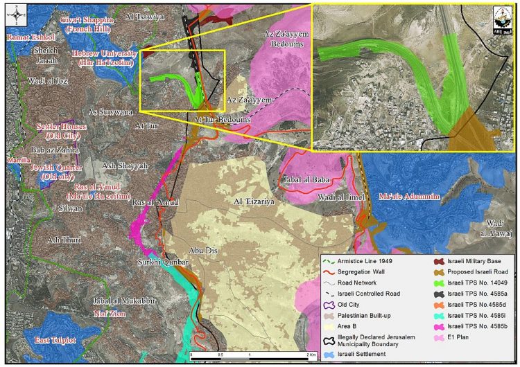
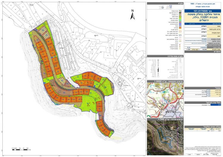
The Israeli Local Planning and Building Committee of the Municipality of Jerusalem is set to approve the seizure of 4.2 dunums of land in Az Zayem town in occupied East Jerusalem to complete the construction of an Interchange, “Az-Zayeim interchange”, which is a separation road system between Israeli and Palestinian traffic in occupied East Jerusalem. The interchange is being constructed near Az-Zayeim checkpoint and comes as part of plan number (TPS 14049) which was approved by the Jerusalem Municipality back in July 2013 and stated the confiscation of 154.595 dunums that time. Since then, the Israeli Municipality of Jerusalem has been working to finish the construction of the interchange under the pretext of facilitating traffic in the area, while creating a system of apartheid roads, one for Israelis and another for the Palestinians. See Photo 1
Photo 1: Israeli TPS no. 14049
Analysis of TPS No. 14049 shows that the interchange is going to facilitate the connection between Israeli settlements inside the city of Jerusalem and settlements around as it will offer safe, easy and multi-passage system for settlers living in Israeli Settlements in occupied East Jerusalem apart from that of the Palestinians; at the same time, the interchange will deepen the separation between Palestinians and Israelis in the area.
Travelling through the new interchange, Israeli settlers living/working in settlements in Jerusalem city (mainly Ramat Eashkol, the French Hill (Giv’at Shappira) and Hebrew University (Har Hatzofim)) will be able to travel to the east (and vice versa), (mainly to Ma’ale Adumim settlement bloc.) without having to stop at a single traffic light as several road connections will emerge as a result of this new construction.
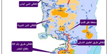
Note that Az Zayeim interchange is part of a huge Israeli Road network that is being implemented in the occupied city of Jerusalem with the aim to encourage the control of more Palestinian land and consequently the establishment of settlements and neighborhoods in the city of Jerusalem in specific and around. Additionally, the construction of such roads and interchanges will create facts on the ground that will be hard to change in the future. Map 1 shows the Israeli bypass roads that have been constructed throughout the years of the Israeli occupation in Jerusalem city and others that are proposed to be constructed in the city.

Map 1: Israeli TPS No. 14049
Israeli bypass roads near completion / completed in occupied East Jerusalem
1- “Begin Road” or Israeli bypass Road 4 on Lands of Beit Safafa and Sharafat
In 2013, the Israeli Moriah Jerusalem Development Company”; in cooperation with the Israeli Municipality of Jerusalem and the Israeli Ministry of Transportation started working to extend the length of the so called “Menachem Begin Road – Road 4” to penetrate deep inside the 1967 borders, on lands of Beit Safafa and Sharafat south of Jerusalem city under the name Road No. 50. Israeli bypass Road No. 50 is designed to benefit mainly Israeli settlers living in settlements south of Jerusalem, mainly in the Gush Etzion settlement Bloc. in Bethlehem Governorate and settlements in Hebron Governorate who will be able to drive to Jerusalem and to areas inside the 1948 lands without having to stop at any single traffic light.
On the 20th of April 2016, the Mayor of Jerusalem Municipality, Nir Barakat, and the Israeli minister of Transportation, Yisrael Katz- and Doron Noioirt, the CEO of Moriah Development company in Israel inaugurated the opening of the third section (Phase three) of the Israeli Bypass road No. 50 – (Known as Begin Road). For more information click here:-
Israel inaugurates the third phase of bypass road No. 50 in occupied East Jerusalem
2- Israeli Bypass Road 21 on lands of Beit Hanina and Shu’fat lands
In July 2013, the Israeli authorities commenced the construction of the bypass Road No. 21 that aims at linking the northern illegal Jerusalem Israeli settlements with each other and regulating access to the future Israeli settlements and neighborhoods that are planned to be built in the city of Jerusalem. The bypass road will first connect with the Israeli bypass road No.9, known to the Israeli as 'Yigal Yadin Boulevard[1]', passing by the settlement of Ramat Shlomo (Reches Shu'fat) from the east, and travels northwards, penetrating through the lands of Shu'fat town and continues along its northern slopes towards Beit Hanina town, cutting through its lands and heading towards its last connection point with Bir Nabala Road (known to the Israeli as Beit Horon Road), where it finally connects with the Atarot Industrial Zone (An Israeli Industrial Zone)[1]. See Map 2
Map 2: Israeli Bypass Road 21
Israeli Bypass Road No. 20 on lands of Beit Hanina
In 2008, the Jerusalem Municipality commenced the construction of a new bypass road, named “Road 20” on lands of Beit Hanina town in occupied East Jerusalem. The bypass road passes through the lands of Beit Hanina to finally connect with the existing Israeli bypass Road No. 443. This road creates a territorial link between the settlements of Pisgat Ze’ev, Pisgat Amir and Neve Ya’akov in the east with settlements in the west and northwest such as Ramot, Ramat Shlomo (Reches Shu’fat) and Giv’at Zeev settlement block. The road extends around 2.5km from the starting point at Pisgat Ze’ev (to the east) and connect with bypass road no.433 (to the west).
Israeli Bypass Road facilitates the construction of settlements
For so long has Israel been marketing for its most unique plan in occupied east Jerusalem, which is the E1 plan, between Ma’ale Adumim settlement bloc (east of Jerusalem) and the city of Jerusalem itself. The construction of the interchange and the proposed Israeli roads in the area (See Map 1) will further encourage the advancement of this plan to its final stages despite international condemnation and even facilitate its connection with Israeli settlements inside Jerusalem city.
The E1 plan includes the building of 3910 housing units west of Ma’ale Adumim settlement in addition to the building of 2152 hotel rooms, an industrial zone and a Police Station (the Police station has already been built in the Ma’ale Adumim area in 2008). It is worth mentioning that the implementation of the E1 plan comes on 13214 dunums of previously confiscated Palestinian lands in East Jerusalem which belong to Al ‘Issawiya, At Tur, Al ‘Ezariyeh, Abu Dis and ‘Anata communities. See Map 3
Map 3: The E1 plan east of Ma'ale Adumim
To sum-up
The new Israeli road interchange obviously serves several major purposes; the first is to encompass much of the land and spaces in the area where it is being constructed; second, to serve the construction of settlements in the city of Jerusalem; third, to create a system of roads for Israeli settlers separate from that of the Palestinians and forth to create a territorial contiguity between settlements in the city of Jerusalem and settlements around.
The confiscation and destruction of Palestinian land is clear violation of the Forth Geneva Convention, Article 147 which clearly prohibits extensive destruction and appropriation of property, not justified by military necessity and carried out unlawfully and wantonly;
Also Israel continues to violate its obligations as an occupying power under international law rules, most notably, the International Covenant on Civil and Political Rights (ICCPR) – Property (ICCPR, article 1) provides that: All peoples have the right of self-determination. By virtue of that right they freely determine their political status and freely pursue their economic, social and cultural development.
- Article XXXI of the 1995 Oslo agreement Israelis forbidden from building or planning any project or settlements or any colonial expansion or any plan that leads to a change of the status of the West Bank and Gaza Strip. The article provides that “Neither side shall initiate or take any step that will change the status of the West Bank and the Gaza Strip pending the outcome of the permanent status negotiations”.
- Article I, Items 2 and 4 of the 1995 Oslo Agreement clearly states that (… the unity and integrity of the Palestinian people in the West Bank and Gaza Strip shall be maintained and respected…). The ”Lateral Roads”, or what people call ”bypass roads” -because they are meant to circumvent (i.e. bypass) Palestinian built up areas, are now disconnecting Palestinian communities from each other.
[1] To assure "transportation contiguity" in Jerusalem
"Israel is constructing a new bypass road north of Jerusalem city at a cost of NIS 112 Million"
http://www.old.poica.org/details.php?Article=4840
Prepared By
The Applied Research Institute – Jerusalem
ARIJ

