• About The Project
  • Palestine in Century
  • Selected Maps
  • Glossary
  • About ARIJ
  • About LRC
  • By Year
    • Case Studies By Year
    • Daily Report By Year
Saturday, May 31, 2025
POICA
No Result
View All Result
  • Home
  • Settlements
    • New Israeli Settlements
    • Settlement Expansion
  • Israeli Violations
    • Agriculture
    • Confiscation
    • Demolition
    • Environment
    • Eviction of Palestinians
    • Settlers Attacks
  • Bypass Roads
  • Israeli Plans
  • Segregation
    • Checkpoints
    • Closure
    • Separation Plans
  • Military Orders
  • Reports
    • Daily Report
    • Monthly Report
    • Quarterly Report
No Result
View All Result
POICA
No Result
View All Result

The occupation announces colonial plans to expand 4 settlements on an area of 850 dunums

July 5, 2022
in Settlement Expansion
The occupation announces colonial plans to expand 4 settlements on an area of 850 dunums


The Israeli occupation authorities announced the deposit of detailed plans to expand four settlements built on citizens’ lands in the governorates of Nablus, Salfit and Bethlehem.

The settlement subcommittee of the so-called Civil Administration published four plans for the expansion of colonies (Elkana, Elon Moreh, Har Gillo, Rahalim), and thus announced that they were filed for objection for a period of (60 days) from the date of their publication.

The Geographic Information Systems Unit at the Land Research Center has drawn up the plans that came as follows:

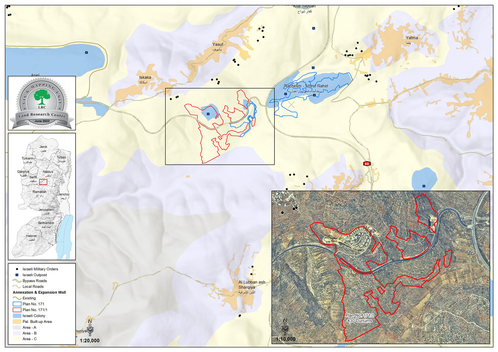
First: Plan №. (1/171) for the expansion of the settlement of “Rahalim” built on the lands of Salfit Governorate. The area of lands covered by the scheme reached (430 dunams), as the outpost (the settlement neighborhood) located to the west of the settlement will be legalized, and more lands will be included. The construction of (212) new settlement units, as it was noted that this plan almost touches the borders of the classified “B” area of the Palestinian Authority administration.

See attached map № 1

This plan is based on parts of the natural basins from the lands of the towns of Al-Sawiya, Al-Lubban Al-Sharqi, and Sakaka, and Yatma as follows:

  • Basin №. 8- Part of the area of Al-Talma land from the lands of the village of Al-Sawiya.
  • Basin №. 7 – part of the Wadi Yusuf area from the lands of the village of Al-Sawiya
  • Basin №. 6- Part of the Qena area in the lands of the village of Al-Sawiya.
  • Basin №. 6 – a part of the Warat Hussein area from the lands of the village of Al-Sawiya.
  • Basin №. 7- Part of the ‘Ashara area of the lands of the village of Al-Sawiya.
  • Basin №. 8 – part of the area of Khallet Wasel from the lands of the village of Al-Sawiya
  • Basin №. 8- A part of the Hareq Abdel Razek fire area from the lands of the village of Al- Sawiya.
  • Basin №. 8 – a part of the Weret Antar area from the lands of the village of Al-Sawiya.
  • Basin №. 9 – part of the Khallet Hammoud area – from the lands of the eastern al-Lubban village.
  • Basin №. 9 – part of the Wadi Yusuf area from the lands of the eastern al-Lubban village.
  • Basin №. 3- Part of the Qena area in the lands of Sakaka village.
  • Basin №. 3- Part of the Khallet Al-Abees area in the lands of Sakaka village.
  • Basin №. 5 – part of Harikat Abu Sarhan area – from the lands of Sakaka village.
  • Basin №. 5- Part of the Wad Salem area from the lands of Sakaka village.
  • Basin №. 7- Part of the Al-Jameh area from the lands of the village of Yatma.

Second: Plan №. (1/4/401) for the expansion of the “Har Gillo” settlement built on the lands of Bethlehem Governorate. The area of the plots covered by the plan has reached (200 dunams), where a new settlement neighborhood will be established to the southwest of the existing settlement there.

See attached map № 2

This plan will include the lands of the villages of Walaja and Battir, and in the following locations and basins:

  • Basin №. 3, part of the Sarj area from the lands of the town of Al Walaja.
  • Basin №. 3 is part of the Khallet Al-Nafla area from the lands of Al-Walajah town.
  • Basin №. 16, part of the area of the baten Ibn Horus from the lands of the town of Battir.

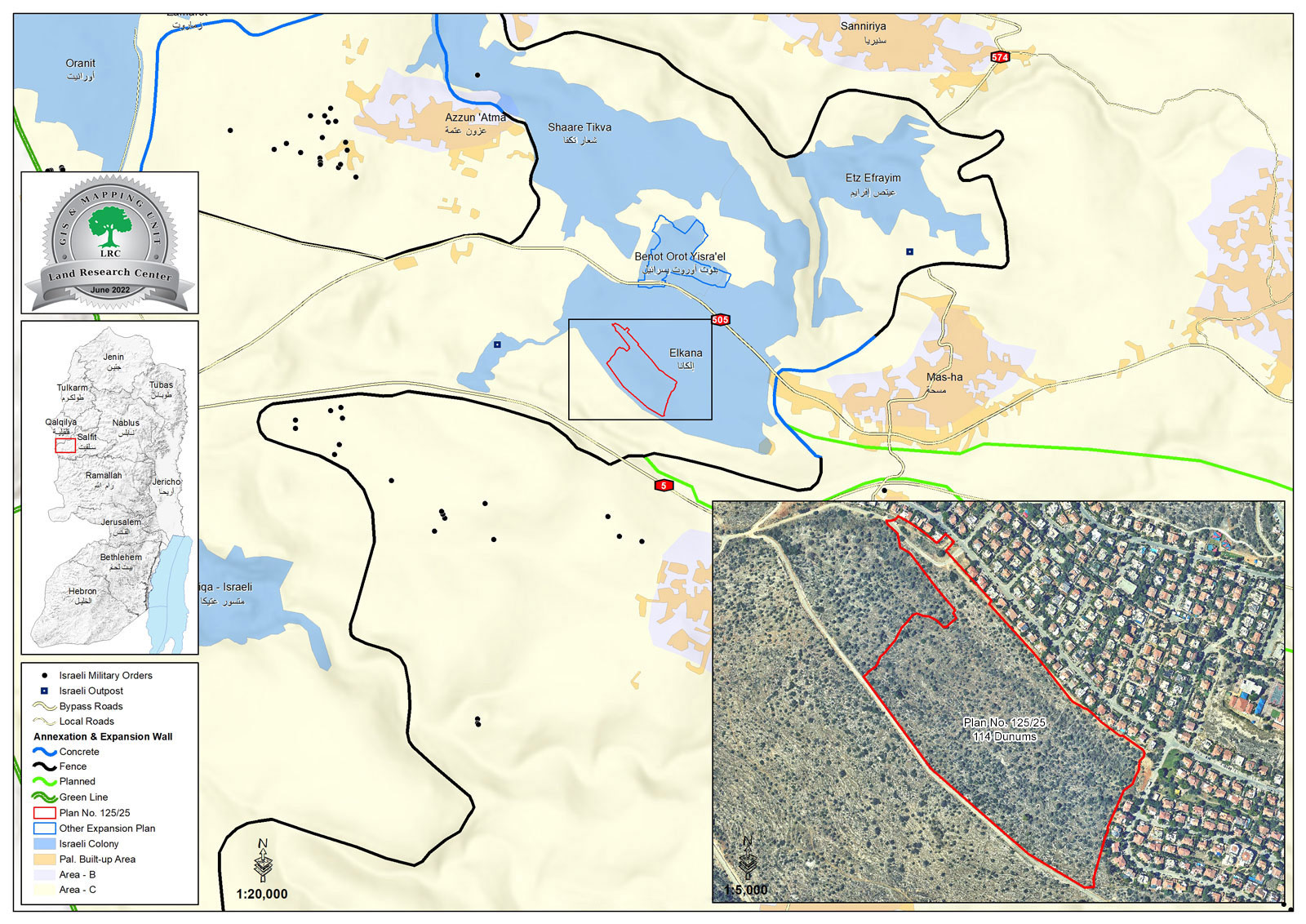
Third: Plan №. (125/125) for the expansion of the “Elkana” settlement built on the lands of Salfit Governorate, where this plan will include an area of (110) dunams, and aims to establish a new settlement neighborhood (350 settlement units) on the western edge of the existing settlement there.

See attached map №. 3

The plan will be imposed on the Palestinian citizens’ confiscated lands in the town of Mas-ha, which is located in Natural Basin No. 3 – part of the Western Wajh site.

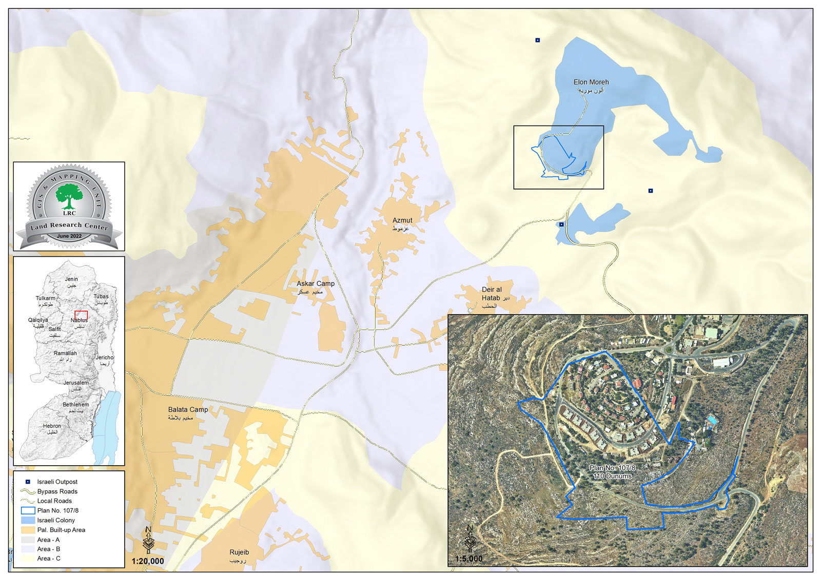
Fourth: Plan №. (107/8) for the expansion of the settlement of ” Elon Moreh” built on the lands of Nablus Governorate, where this plan will be imposed on an area of (110) dunams of the Palestinian citizens’ confiscated lands, with the aim of establishing a new colonial neighborhood to the west of the settlement.

See attached map No. 4

This scheme will be imposed on parts of the Palestinian citizens’ lands in Basin №. 8 of the lands of Deir Al-Hatab, and Basin №. 10 of Azmut lands.


Prepared by
The Land Research Center
LRC


Recommended For You

Expansion of Gilo Settlement: A Strategic Plan to Isolate Bethlehem and Undermine Palestinian Rights

by arij
May 12, 2025
0
Expansion of Gilo Settlement: A Strategic Plan to Isolate Bethlehem and Undermine Palestinian Rights

The Israeli Civil Administration has announced a new settlement expansion plan—No. 101-1284223—which outlines the construction of 1,990 new settlement units on approximately 175.9 dunums of land extending towards...

Read moreDetails

إسرائيل تمضي قدمًا في مخطط استيطاني جديد على أراضي مدينة بيت جالا، في انتهاك للقانون الدولي وحرمان الفلسطينيين من أراضيهم

by arij
April 29, 2025
0
Israel Advances Settlement Plan on Ancient Olive Groves on lands of Beit Jala city, Violating International Law and depriving Palestinians their lands

  في أواخر شهر شباط من العام 2025، صادقت دولة الاحتلال الإسرائيلي على مخطط استيطاني جديدة لبناء حي سكني للمستوطنين على مساحة 22.2 دونما من الأراضي الفلسطينية لتابعة...

Read moreDetails

سلطات الاحتلال الإسرائيلي تصادر 64 دونما شمال مدينة بيت لحم لإقامة موقفا للحافلات

by arij
October 19, 2023
0
سلطات الاحتلال الإسرائيلي تصادر 64 دونما شمال مدينة بيت لحم لإقامة موقفا للحافلات

  في السابع من شهر أيلول من العام 2023, صادقت بلدية الاحتلال الإسرائيلي في القدس المحتلة على مخطط استيطاني جديد من شأنه أن يصادر مساحات شاسعة من أراضي...

Read moreDetails

Israeli Settlements in the Occupied West Bank: from “outposts” to urban blocks

by arij
May 20, 2023
0
Israeli Settlements in the Occupied West Bank: from “outposts” to urban blocks

  The Applied Research Institute – Jerusalem (ARIJ) In cooperation with Palestine Economic Policy Research Institute (MAS)   Preface Legalizing nine Israeli settlement outposts in the occupied West...

Read moreDetails

استكمال انشاء حي استعماري تابع لمستعمرة ” الكانا” على أراضي قرية مسحة / محافظة سلفيت

by arij
November 1, 2022
0
استكمال انشاء حي استعماري تابع لمستعمرة ” الكانا” على أراضي قرية مسحة / محافظة سلفيت

  الانتهاك: توسع استيطاني. الموقع: قرية مسحة / محافظة سلفيت. تاريخ الانتهاك: تشرين أول 2022. الجهة المعتدية: مستعمرة " الكانا". الجهة المتضررة: أهالي قرية مسحة.  تفاضيل الانتهاك:   استكمل...

Read moreDetails
Next Post

ARIJ Daily Report – Wed 15th 06 2022

LATEST NEWS

Expansion of Gilo Settlement: A Strategic Plan to Isolate Bethlehem and Undermine Palestinian Rights

Expansion of Gilo Settlement: A Strategic Plan to Isolate Bethlehem and Undermine Palestinian Rights

by arij
May 12, 2025
0

........................................................

الأراضي الفلسطينية بين الذرائع الأمنية والأطماع الاستيطانية – “الأمن، الآثار، والطبيعة كحجج لاقتلاع الفلسطينيين من أراضيهم”

by arij
April 15, 2025
0

........................................................

الطرق الالتفافية الاسرائيلية وأثرها على البيئة الفلسطينية

انتهاك للطبيعة والهوية في الأراضي الفلسطينية المحتلة

by arij
March 17, 2025
0

........................................................

Israel Advances Settlement Plan on Ancient Olive Groves on lands of Beit Jala city, Violating International Law and depriving Palestinians their lands

إسرائيل تمضي قدمًا في مخطط استيطاني جديد على أراضي مدينة بيت جالا، في انتهاك للقانون الدولي وحرمان الفلسطينيين من أراضيهم

by arij
April 29, 2025
0

........................................................

flag_yellow_lowEU-PfP-Logo

This website has been produced with the assistance of the European Union. The contents of this publication are the sole responsibility of ARIJ & LRC and can in no way be taken to reflect the views of the European Union.

© 2025 Copyright ARIJ . All Rights reserved. .

No Result
View All Result
  • Home
  • Settlements
    • New Israeli Settlements
    • Settlement Expansion
  • Israeli Violations
    • Agriculture
    • Confiscation
    • Demolition
    • Environment
    • Eviction of Palestinians
    • Settlers Attacks
  • Bypass Roads
  • Israeli Plans
  • Segregation
    • Checkpoints
    • Closure
    • Separation Plans
  • Military Orders
  • Reports
    • Daily Report
    • Monthly Report
    • Quarterly Report

© 2025 Copyright ARIJ . All Rights reserved. .