The Israeli District Planning Committee in Jerusalem Municipality has given the green light to advance the construction of 540 settlement units in Har Homa settlement under the name “Har Homa E”, on a vacant land northwest of the existing Har Homa settlement, north of Bethlehem city.
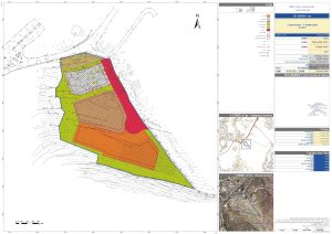
Earlier in December 2020, the Jerusalem city planning and building committee deposited the settlement plan for approval but was awaiting approval at a higher level. The plan holds Town Planning Scheme No. 285411 and states the construction of 540 settlement units on 27.6 dunums of land belonging to Bethlehem Governorate.
Photo 1: Town Planning Scheme No. 101-0285411
The new settlement comes as part of a larger plan that is going to be implemented in the area, named “Har Homa E or Har Homa West” and include the construction of 2200 settlement units under TPS No. 15399
The “Har Homa E” or “Har Homa West” settlement will be built to the west of the existing Har Homa (Abu Ghneim) settlement, on the vacant land between Har Homa and Giv’at Hamatos settlements, north of Bethlehem city. The location of planned settlement is (Har Homa E) is located under the control of Jerusalem Israeli Municipality, which was, illegally and unilaterally, declared and expanded in 1967 after the Israeli occupation of the West Bank including East Jerusalem, in addition to Gaza Strip.
A new settlement road facilitating the establishment of “Har Homa West”
During the past few years, Israel constructed a new bypass road, which extends from the northwest end of Har Homa settlement towards Bethlehem-Jerusalem Road, to connect with the Tantour Junction. The construction of the new bypass road served the Israeli plans in the area, which is to establish the aforementioned settlement. The construction of the road comes as part of TPS number 12626, which states the confiscation of 141.7 dunums of land for the construction of the aforementioned bypass road.
Photo 2 : Town Planning Scheme No. 12626
Completing the ring of Israeli settlements north of Bethlehem city
“Har Homa E” settlement plan will serve as another step in completing the ring of Israeli settlements north of Bethlehem area and consequently cutting-off the city of Bethlehem from its historical and geographical ties with Jerusalem. See Map 1
Map 1: The ring of Israeli settlements and settlement plans north of Bethlehem
Prepared by:
The Applied Research Institute – Jerusalem


