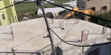
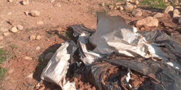
- Violation: Demolishing a Retaining Wall and a Siege.
- Location: Jubara village / Tulkarm governorate.
- Date: February 2nd 2021.
- Perpetrators: The Israeli Occupation Civil Administration.
- Victims: Citizen Abdul Hameed Ad-Dusouqi.
Description:
The Israeli Occupation Forces accompanied by state properties inspector in the Israeli Civil Administration raided Jubara village south Tulkarm , the Occupation throughout a Caterpillar bulldozer demolished cement walls and a metal siege with a total area of 90 m * 2 m that surround a one-dunum plot planted with Avocado on the pretext of violating a governmental property.
The targeted plot belong to Abdul Rahman Desouqi , and located nearby the southern entrance of Jubara village in an area known as Khallet Humadi in natural block 2.
The Owner received an eviction notice early October, when the governmental properties officer raided the area and put the notice on the retaining walls, the owner assigned a lawyer to follow up the case.


 Photos 1-5: The demolished retaining walls
Only five meters away the Occupation in September 23rd 2020 , carried on a massive demolition operation that leveled a wedding hall with an area of 1400 m2, belong to Hanan Abu Jaber on the pretext of violating a state property, read our report on this case.
About Jubara: [1]
7 km to the south of Tulkarem city , Jubara is border by Faro’un village (north), occupied territories of 1948 (west), Shofa village (east), Kafl Al-Jamal and Flamiy (south) . Its population mounts to 313 according to 2017 census.
Families of the town: Jubara, Mahmoud, Awad and Odeh. The town has a total area of 46,914 dunums , of which 73 dunums are the town’s built up area.
Israeli settlements devoured 1068 dunums of the town’s land:
- Sal’it settlement (1977) devourd 921 dunums and populated 441 settlers.
- Ya’arit devoured 147 dunums.
The segregation wall devoured 1531 dunums, and isolated 12,212 dunums.
Oslo conventions divided Jubara into B and C areas:
- B area : 29862 dunums.
- C area: 17052 dunums.
[1] GIS- LRC


