• About The Project
  • Palestine in Century
  • Selected Maps
  • Glossary
  • About ARIJ
  • About LRC
  • By Year
    • Case Studies By Year
    • Daily Report By Year
Monday, August 18, 2025
POICA
No Result
View All Result
  • Home
  • Settlements
    • New Israeli Settlements
    • Settlement Expansion
  • Israeli Violations
    • Agriculture
    • Confiscation
    • Demolition
    • Environment
    • Eviction of Palestinians
    • Settlers Attacks
  • Bypass Roads
  • Israeli Plans
  • Segregation
    • Checkpoints
    • Closure
    • Separation Plans
  • Military Orders
  • Reports
    • Daily Report
    • Monthly Report
    • Quarterly Report
No Result
View All Result
POICA
No Result
View All Result

Halting Road Rehabilitation-  west Deir Istiya / Salfot governorate

December 14, 2020
in Military Orders
Halting Road Rehabilitation-  west Deir Istiya / Salfot governorate


  • Violation: Halting road rehabilitation on the pretext of working without licenses.
  • Location: Deir Istiya village / North West Salfit city.
  • Date: June 25th
  • Perpetrator: The Israeli Occupation forces.
  • Victims: Deir Istiya farmers.
  • Description:

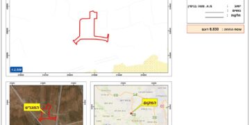
Thursday, June 25th 2020, the Israeli Occupation forces prohibited people of Deir Istiya northwest Salfit from rehabilitating an agricultural road west the village in Hariqat Al-wad location.

A massive army force raided the area and forced the contractor to halt road rehabilitation and withdraw from the location, and threatened that in case he refused to leave, the Occupation forces will confiscate the machineries and prohibit rehabilitation.

The targeted road was implemented by Union of Agricultural Work Committee with the supervision of the Ministry of Agriculture and contribution of the Deir Istiya’s village council , the road was supposed to be 2 *4 km2 , the road was leveled with base course and supposed to serve more than 350 dunums of olive groves in Wad Qana that belong to number of farmers.


Deir Istiya village council head Nathmi Salman told LRC:

“Since the beginning of year 2020, the Israeli Occupation forces closed off and halted work on three agricultural roads in Dair Istiya . the new road was supposed to serve tens of agricultural dunums at the village. This is only a reflection of the occupation’s intention to take over vast areas of the town’s lands for the sake of Nofeem , Yakir, Havat Yaer and Immanuel colonies’ expansion , this also paves the road for Land Judaization , and banning farmers’ access to their lands in order to annex them later.”

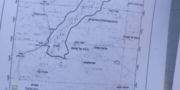
Deir Istiya village: [1]

10 km north Salfit , Deir Istiya is surrounded by Ematin , Jinsafut and Kafr Laqif (north), Azzun and Kafar Thulth (west), Zita, Jama’en and Kafl Haris (east), Haris and Qaraqwat Bani Hyssan (south)

Deir Istiya has a population of (3,696) people in 2017 census.

The town has a total area of 34,125, of which 640 dunums are a built up area. 

The Israeli occupation confiscated (4,257) dunums for the following purposes:

Settlement name

Establishment year

Area in dunums

Number of settlers 2018

Revava

1991

167

2,664

Yakir

1981

757

2,341

Ginat Shomron

1985

944

NA

Karnei Shomron

1978

540

8,388

Novim

1986

663

867

Immanuel

1981

879

4,220

Ma’ale Shomron

1980

52

1,002

Al-Matan

1981

22

NA

  • Bypass roads 55 and 5066 devoured 118 dunums.
  • The segregation wall (1,148 m ate up115 dunums , in case its construction plan was completed it will isolate 8,408 dunums and eat up 160 dunums.

Oslo accords classified Deir Istiya as the following :

  • B area : 6,132 dunums.
  • C area 27,993 dunums.

[1] GIS-LRC


Prepared by
The Land Research Center
LRC

Recommended For You

“سيطرة من تحت الأرض”, بواقع 108 أمرا عسكريا, سيطرة اسرائيلية على مياه الفلسطينيين في الضفة الغربية المحتلة

by arij
August 12, 2025
0
بواقع 86 أمرا عسكريا – الأوامر العسكرية الإسرائيلية, الأداة الرئيسية للاحتلال الاسرائيلي للسيطرة على المياه الفلسطينية في الضفة الغربية المحتلة

مقدمة، لطالما شكّلت أزمة المياه إحدى القضايا الأكثر صعوبة في الأراضي الفلسطينية المحتلة، إلا أنها في العقود القليلة الماضية اتخذت منحًنا تصاعديًا خطيرًا، حتى بلغت مستويات غير مسبوقة....

Read moreDetails

تهويد صامت بالأمتار: الطريق إلى بني كيديم خطوة نحو الشرعنة الاستيطانية

by arij
July 16, 2025
0
تهويد صامت بالأمتار: الطريق إلى بني كيديم خطوة نحو الشرعنة الاستيطانية

في الثامن عشر من شهر حزيران من العام 2025، تسلّم أهالي بلدتي سعير والشيوخ الواقعتين شمال شرق محافظة الخليل أمراً عسكرياً إسرائيلياً جديداً يقضي بمصادرة 4.8 دونما من...

Read moreDetails

من غير شرعية إلى واقع مفروض, البؤرة الاستيطانية سدي بوعز في رعاية الاحتلال

by arij
July 15, 2025
0

في الثامن من شهر تموز من العام 2025، سلّمت سلطات الاحتلال الإسرائيلي أمرًا عسكريًا جديدًا يقضي بمصادرة أراضٍ فلسطينية وممتلكات خاصة في بلدة الخضر جنوب غرب محافظة بيت...

Read moreDetails

ملاخي هشالوم: أكثر من مجرد بؤرة استيطانية … مشروع تهويد وتوسّع اسرائيلي

by arij
July 10, 2025
0
ملاخي هشالوم: أكثر من مجرد بؤرة استيطانية … مشروع تهويد وتوسّع اسرائيلي

قامت سلطات الاحتلال الإسرائيلي بتاريخ 7 تموز 2025 بنشر أمر عسكري جديد في الضفة الغربية المحتلة، يحمل عنوان: "أمر بشأن الأملاك الحكومية (يهودا والسامرة) (رقم 59) لسنة 1967"....

Read moreDetails

Israeli Order Targets Zububa Village Under Security Claims

by arij
June 24, 2025
0
أمر عسكري إسرائيلي يستهدف أراضي قرية زبوبا الفلسطينية لأغراض أمنية مستعجلة

As part of Israel's systematic violations against Palestinian land in the occupied West Bank", the Israeli occupation authorities, on June 14, 2025, issued a new military order to...

Read moreDetails
Next Post
وقف  العمل بتـأهيل  طريق زراعي غرب بلدة دير إستيا بمحافظة سلفيت

وقف  العمل بتـأهيل  طريق زراعي غرب بلدة دير إستيا بمحافظة سلفيت

LATEST NEWS

مشروع (E1): الضربة القاضية لحل الدولتين وإعادة تشكيل الخريطة الجيوسياسية للضفة الغربية

The Government Pushes Forward Plans in E1, Considered a Death Blow to the Two-State Solution

by arij
August 16, 2025
0

........................................................

مشروع (E1): الضربة القاضية لحل الدولتين وإعادة تشكيل الخريطة الجيوسياسية للضفة الغربية

مشروع (E1): الضربة القاضية لحل الدولتين وإعادة تشكيل الخريطة الجيوسياسية للضفة الغربية

by arij
August 16, 2025
0

........................................................

بواقع 86 أمرا عسكريا – الأوامر العسكرية الإسرائيلية, الأداة الرئيسية للاحتلال الاسرائيلي للسيطرة على المياه الفلسطينية في الضفة الغربية المحتلة

“سيطرة من تحت الأرض”, بواقع 108 أمرا عسكريا, سيطرة اسرائيلية على مياه الفلسطينيين في الضفة الغربية المحتلة

by arij
August 12, 2025
0

........................................................

تصعيد إسرائيلي جديد: الاحتلال يهدم مبنى في بيت لحم ويواصل سياسة التطهير المكاني

تصعيد إسرائيلي جديد: الاحتلال يهدم مبنى في بيت لحم ويواصل سياسة التطهير المكاني

by arij
August 12, 2025
0

........................................................

flag_yellow_lowEU-PfP-Logo

This website has been produced with the assistance of the European Union. The contents of this publication are the sole responsibility of ARIJ & LRC and can in no way be taken to reflect the views of the European Union.

© 2025 Copyright ARIJ . All Rights reserved. .

No Result
View All Result
  • Home
  • Settlements
    • New Israeli Settlements
    • Settlement Expansion
  • Israeli Violations
    • Agriculture
    • Confiscation
    • Demolition
    • Environment
    • Eviction of Palestinians
    • Settlers Attacks
  • Bypass Roads
  • Israeli Plans
  • Segregation
    • Checkpoints
    • Closure
    • Separation Plans
  • Military Orders
  • Reports
    • Daily Report
    • Monthly Report
    • Quarterly Report

© 2025 Copyright ARIJ . All Rights reserved. .