• About The Project
  • Palestine in Century
  • Selected Maps
  • Glossary
  • About ARIJ
  • About LRC
  • By Year
    • Case Studies By Year
    • Daily Report By Year
Friday, October 3, 2025
POICA
No Result
View All Result
  • Home
  • Settlements
    • New Israeli Settlements
    • Settlement Expansion
  • Israeli Violations
    • Agriculture
    • Confiscation
    • Demolition
    • Environment
    • Eviction of Palestinians
    • Settlers Attacks
  • Bypass Roads
  • Israeli Plans
  • Segregation
    • Checkpoints
    • Closure
    • Separation Plans
  • Military Orders
  • Reports
    • Daily Report
    • Monthly Report
    • Quarterly Report
No Result
View All Result
POICA
No Result
View All Result

Israeli land leveling in Al Khader village waves for new settlement activities in the area

February 17, 2018
in Military Orders
Israeli land leveling in Al Khader village waves for new settlement activities in the area


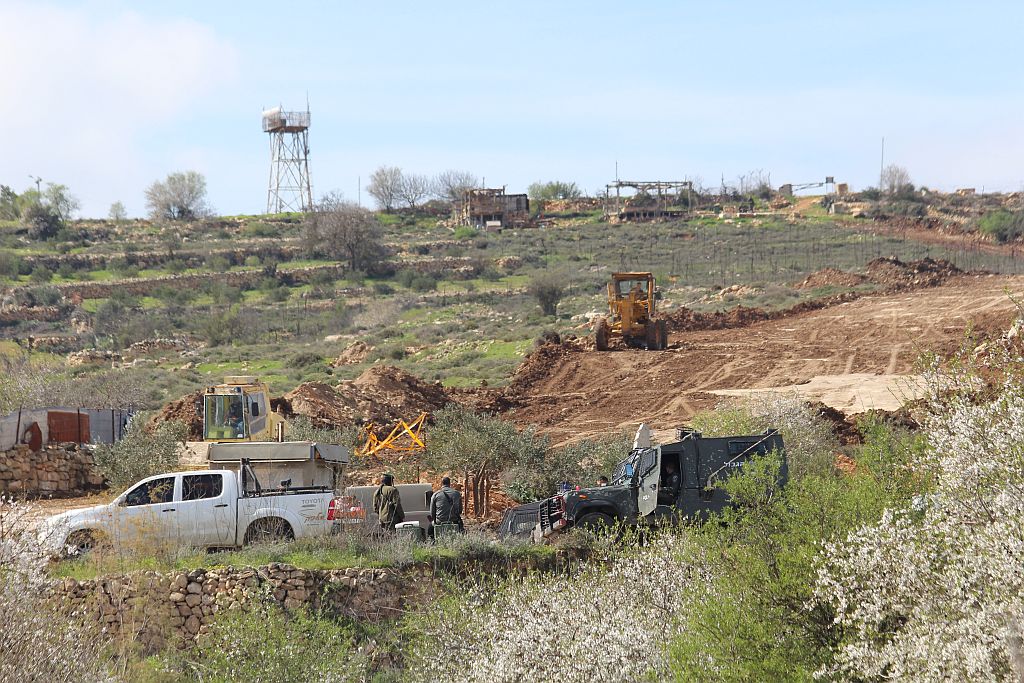
On the 8th of February 2018, Israeli heavy machinery escorted by the Israeli Occupation Army (IOA) started leveling lands in Al Khader village west of Bethlehem. The targeted land is located north of Eli’azer settlement, alongside the so-called “Israeli Bypass Road No. 60[1]”.  A field visit to the targeted site showed a new road is being constructed on lands of al Khader based on previously issued military orders namely 18/7/MD, 18/6/MD18/5/MD, 18/4/MD and 18/3/MD that state the confiscation of 67.7 dunums of land in total (24.545 dunusm, 11.886 dunums, 18.486 dunums, 6.39 dunums, and 6.431 dunums respectively). Furthermore, Palestinian land owners were prevented from accessing their lands which are being leveled and destructed in the moment as the Israeli Occupation Army (IOA) declared the area where land leveling is taking place as a “closed military zone”, and installed two new iron gates, preventing Palestinians from coming nearby. See Map 1

Map 1: Palestinian Lands targeted in the military Orders 
 

Furthermore, on the 13th of February 2018, the Israeli daily newspaper, Times of Israel, reported that Israel has advanced a handful of settlement projects throughout the occupied West Bank, including a plan to build what it called as  “temporary” settlement to house the settlers of the illegal Netiv Ha’avot outpost which is slated for demolition by the 6th of March 2018. The newspaper added that the Israeli Civil Administration’s High Planning Subcommittee granted final approval for 17 temporary homes to be built for the 15 settler families whose homes are set to be razed with regard to a petition filed by a group of Palestinian landowners testifying that  the settlers homes were built on Private Palestinian land in the area. The planned temporary settlement homes will be placed in an area adjacent to the nearby Alon Shvut settlement, in the Gush Etzion bloc, thus threatening the whole area to become under the Israeli control in the near future. See Map 2

Map 2: The planned settlement for settlers of Natve Ha'avot 


The Temporary settlement plan of Native Ha’avot holds number 405/11 and is slated to confiscate 41 dunums of Al Khader village lands. The plan declares change in land status with regard to chapter No. 20/24 of  the Israeli City, Village, and Building Planning Law no. 79 of 1966. See copy of the Israeli AD as posted on the Israeli Interior ministry website

Photo 1-3: AD as posted on the Israeli Interior ministry website

Provisions of the plan come as follows

  • Land Rezoning from industrial area to temporary residential area and open public space.
  • Land Rezoning from open public space  to An area whose designation will be determined in the future
  • Determination of various permissible land Uses.
  • Outlining the various road network classification.
  • Setting limits and provisions in the area with regard to construction plan.
  • Determining conditions, stages of implementation and development phases required for the operational agency. Details of TPS No. 405/11

Table 1: Details of Israeli TPS No. 405/11  on lands of Al Khader village

Type of Construction

Current Situation

Area with regard to plan

Area (Dunums)

%

Area (Dunums

%

No. of Units

Residential area in temporary structures

—–

—-

18.402

45.02

17

Planned Road

—-

—-

1.381

3.38

—-

Approved Road

18.950

46.36

18.950

46.36

—-

Open Public Area

0.345

0.85

2.141

5.24

—-

An area whose designation will be determined in the future

1.036

2.53


Agricultural land

20.543

50.26

—-

—-

—–


40.874

100

40.874

100

17

Source: Israeli Ministry of Interior, 2018


Analysis conducted by the Applied Research Institute – Jerusalem showed that the projected settlement will be built on land previously declared as “STATE LAND” by the Israeli Custodian of Absentee property. The order was issued on the 6th of April 2014, the “Custodian of Absentee property[2] & Israel Land Authority of Judea and Samaria ” attached to the Israeli Ministry of Defense/Civil Administration, Yousi Sigal, issued a military order to seize 984[7] dunums of land from two Palestinian communities in Bethlehem and Hebron Governorates, Al Khader and Beit Ummer, by declaring it “State Land”.  See Copy of Military Order 
 

https://poica.org/upload/Image/arij_april_2014/havot1.jpg/upload/Image/arij_april_2014/havot2.jpghttps://poica.org/upload/Image/arij_april_2014/havot5.jpg

Photo 4-6: Order Concerning State Property (Judea & Samaria) (No. 59-1967) 
 

The military order shows that the Israeli government had started with the confiscation of 984 dunums of Palestinian land as preliminary step towards expropriating more Palestinian lands in the area that is actually located between the illegal settlements of Ele’azar, Rush Tzurim, Neve Daniel and Alon Shevut, with the purpose of fortifying and consolidating the Gush Etzion Settlement Bloc in general.


[1] locally known to the Palestinians as the Bethlehem-Jerusalem road  


[2] Military Order #59 (1967?) – establishes the Israeli Military-appointed position of "Custodian of Government Property" to take over land owned by the Jordanian Government. Also, allows the "Custodian of Government Property" to appropriate land from individuals or groups by declaring it "Public Land" or "State Land", the latter which it defines as land that was owned or managed by, or had a partner who was an enemy body or citizen of an enemy country during the 1967 war (amended by M.O.1091).


Prepared by:  
The Applied Research Institute – Jerusalem


Recommended For You

سلطات الاحتلال الإسرائيلي تستغل ‘المنفعة العامة’ لنهب الموارد الفلسطينية

by arij
September 30, 2025
0
سلطات الاحتلال الإسرائيلي تستغل ‘المنفعة العامة’ لنهب الموارد الفلسطينية

في الاول من شهر ايلول من العام 2025، نشرت الإدارة المدنية الإسرائيلية، الذراع الأيمن لحكومة الاحتلال الإسرائيلي أمرا عسكريا جديدا تحت عنوان " أمر ءبشأن قانون الأراضي (الاستملاك...

Read moreDetails

The Occupation Targets the Village of Raba Southeast of Jenin with Military Orders and Seizes Vast Areas of Its Lands

by arij
September 13, 2025
0
الاحتلال يستهدف بأوامر عسكرية قرية رابا جنوب شرق جنين ويصادر مساحات واسعة من أراضيها

 The Israeli occupation Army have continued their policy of plundering Palestinian lands, as their bulldozers leveled wide areas of agricultural land in the village of Raba, southeast of...

Read moreDetails

الاحتلال يستهدف بأوامر عسكرية قرية رابا جنوب شرق جنين ويصادر مساحات واسعة من أراضيها

by arij
September 13, 2025
0
الاحتلال يستهدف بأوامر عسكرية قرية رابا جنوب شرق جنين ويصادر مساحات واسعة من أراضيها

  واصلت قوات الاحتلال الإسرائيلي سياسة نهب الأراضي الفلسطينية، حيث أقدمت آلياتها على تجريف أراض زراعية واسعة في قرية رابا جنوب شرق محافظة جنين، تمهيدا لشق شارع عسكري...

Read moreDetails

Nablus Governorate’s Archaeological Sites Face Israeli Expropriation Plans

by arij
September 11, 2025
0
” المواقع الأثرية في محافظة نابلس… ساحة مفتوحة أمام مخططات المصادرة الإسرائيلية “

On 10 August, 2025, the Israeli Civil Administration (ICA), issued a booklet of military orders signed by the head of the so-called ‘Israeli Civil Administration’ in the occupied...

Read moreDetails

” المواقع الأثرية في محافظة نابلس… ساحة مفتوحة أمام مخططات المصادرة الإسرائيلية “

by arij
August 26, 2025
0
” المواقع الأثرية في محافظة نابلس… ساحة مفتوحة أمام مخططات المصادرة الإسرائيلية “

في العاشر من شهر اب من العام 2025, أصدرت الإدارة المدنية الإسرائيلية كراسة أوامر عسكرية موقعة من قبل رئيس ما يسمى "بالإدارة المدنية الإسرائيلية" في الضفة الغربية المحتلة,...

Read moreDetails
Next Post

ARIJ Daily Report – Thu, 15th 02 2018

LATEST NEWS

Annexation of the Jordan Valley: Implications for the Two-State Solution and Regional Stability

Annexation of the Jordan Valley: Implications for the Two-State Solution and Regional Stability

by arij
September 29, 2025
0

........................................................

Isolation of Three Villages Northwest of Jerusalem: Silent Annexation Creeps toward the Capital

عزل ثلاث قرى فلسطينية شمال غرب مدينة القدس: الضم الاسرائيلي الصامت يزحف نحو محيط العاصمة

by arij
September 24, 2025
0

........................................................

Isolation of Three Villages Northwest of Jerusalem: Silent Annexation Creeps toward the Capital

Isolation of Three Villages Northwest of Jerusalem: Silent Annexation Creeps toward the Capital

by arij
September 24, 2025
0

........................................................

سياسات التهويد في القدس: من السيطرة المكانية إلى طمس الهوية عبر التسمية

سياسات التهويد في القدس: من السيطرة المكانية إلى طمس الهوية عبر التسمية

by arij
September 23, 2025
0

........................................................

flag_yellow_lowEU-PfP-Logo

This website and its content were initiated in 1993 by the Applied Research Institute – Jerusalem (ARIJ) and the Land Research Center (LRC) with the support from the European Union up until 2023. Since then, the Applied Research Institute – Jerusalem (ARIJ) has taken over the continued development and maintenance of the website. The views expressed remain solely those of ARIJ) and do not necessarily reflect those of the European Union.

© 2025 Copyright ARIJ . All Rights reserved. .

No Result
View All Result
  • Home
  • Settlements
    • New Israeli Settlements
    • Settlement Expansion
  • Israeli Violations
    • Agriculture
    • Confiscation
    • Demolition
    • Environment
    • Eviction of Palestinians
    • Settlers Attacks
  • Bypass Roads
  • Israeli Plans
  • Segregation
    • Checkpoints
    • Closure
    • Separation Plans
  • Military Orders
  • Reports
    • Daily Report
    • Monthly Report
    • Quarterly Report

© 2025 Copyright ARIJ . All Rights reserved. .