• About The Project
  • Palestine in Century
  • Selected Maps
  • Glossary
  • About ARIJ
  • About LRC
  • By Year
    • Case Studies By Year
    • Daily Report By Year
Tuesday, August 26, 2025
POICA
No Result
View All Result
  • Home
  • Settlements
    • New Israeli Settlements
    • Settlement Expansion
  • Israeli Violations
    • Agriculture
    • Confiscation
    • Demolition
    • Environment
    • Eviction of Palestinians
    • Settlers Attacks
  • Bypass Roads
  • Israeli Plans
  • Segregation
    • Checkpoints
    • Closure
    • Separation Plans
  • Military Orders
  • Reports
    • Daily Report
    • Monthly Report
    • Quarterly Report
No Result
View All Result
POICA
No Result
View All Result

Israel to establish new outpost on Jalud’s land in Nablus governorate

July 18, 2017
in New Israeli Settlements
الإعلان عن إنشاء مستعمرة جديدة  بديلة عن البؤرة ” عمونة” على أراض قرية جالود


  • Violation: advertisement to establish new outpost
  • Location:  Jalud village- Nablus
  • Date:  June 06, 2017
  • Perpetrators: Israeli Occupation Government
  • Victims:  farmers and land owners

Details:

 The government of Israel declared on June 06, 2017 the ratification of a decision to establish new outpost called "Aimehai" as a replacement for Amona outpost.

Resources said that preparation for the construction of 102 residential unit are being taking place south Nablus governorate. The units will accommodate 40 Israeli families evacuated from Amona outpost.

It should be noted that Israel Ministry of Interior mentioned on its webpage that Higher Planning Council- Israel Civil Administration deposited the new master plan number 252/1 stating the change of use for 1920 dunums from agricultural to urban development.

The targeted lands are founded within the natural block number 4 from the lands of Turmus'ayya in Ramallah and the natural block number 16 from the lands of Jalud village. Noteworthy, the targeted lands are agriculturally unused and that colonists tried hard to take them over to establish outpost in there.


Photos 1-2: the plans ( source :Peace Now movement)

 
Photos 3-7: the plan featured on Israel Ministry of Interior webpage

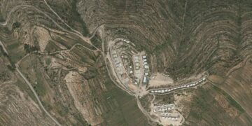
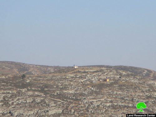
According to the team of field research at Land Research Center, the location of the new outpost will be between the colonies of Shevut Rahel and Adi Ad. This will create a geographical connection between both colonies and eventually result in the creation of a colonial bloc that separates the northern part of the West Bank from the southern one.


Photo 8: the new location for the proposed outpost


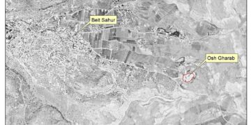
Photos 9-10: the location of new outpost from the side of Shevut Rahel colony


About Jalud:

Jalud  is located 29km to the southeast of Nablus city and is edged by Qusra village from the northeast,  Qaryut village from the west, Yesh Kodish and Ahya outposts  from the east and Shilo colony from the south.

Its population mounts up to 598 people (2014 census). Jalud's total land area is 22,473 dunums, of 80 dunums are considered the village's built-up area.

Israeli colonies confiscated 2227 dunums from Jalud lands. Shilo colony that was established in 1978 confiscated 640 dunums from the village. Mizpe Rahel colony and other outposts namely (Yesh Kodish, Ahya, Eli, Adi Ad and Kida) are founded on confiscated lands from the villg.

Bypass roads confiscated around 436 dunums from the village.

The lands of Marda are classified according to Oslo Accords as the following:

  • 5541 dunums (25%) are classified as area B
  • 16932 dunums (75%) are classified as area C


Prepared by
 The Land Research Center
LRC


Recommended For You

Escalation and forced displacement in Kisan

by arij
August 6, 2025
0

The village of Kisan, located southeast of the Bethlehem Governorate, has faced continuous attacks for many years by settlers and Israeli occupation forces as part of a systematic...

Read moreDetails

بؤرة استيطانية جديدة وتهجير قسري في كيسان

by arij
August 6, 2025
0

موقع الاستهداف، تقع قرية كيسان جنوب شرق محافظة بيت لحم، وتواجه منذ سنوات طويلة هجمات متواصلة من قبل المستوطنين وقوات الاحتلال الإسرائيلي ضمن سياسة ممنهجة تهدف إلى السيطرة...

Read moreDetails

“الاستيطان الإسرائيلي يستحوذ على ما تبقى من المساحات الخضراء في محافظة بيت لحم

by arij
August 19, 2024
0
“الاستيطان الإسرائيلي يستحوذ على ما تبقى من المساحات الخضراء في محافظة بيت لحم

أعلن ما يسمى بوزير المالية والوزير في وزارة الاحتلال الإسرائيلي بتسلئيل سموتريتش يوم الرابع عشر من شهر اب من العام 2024 عن قراره بإقامة مستوطنة إسرائيلية جديدة على...

Read moreDetails

إسرائيل تعطي الضوء الأخضر لبناء مستوطنة جديدة في قلب مدينة الخليل

by arij
April 24, 2024
0
إسرائيل تعطي الضوء الأخضر لبناء مستوطنة جديدة في قلب مدينة الخليل

  أعلنت الإدارة المدنية الإسرائيلية، الذراع الأيمن لحكومة الاحتلال الاسرائيلي في الضفة الغربية المحتلة, في الاسبوع الاول من شهر نيسان من العام 2024, عن مخططا استيطانيا جديدا يستهدف...

Read moreDetails

مستوطنة جديدة تبصر النور على أراضي بلدة دير استيا

by arij
August 15, 2022
0
مستوطنة جديدة تبصر النور على أراضي بلدة دير استيا

   صادقت سلطات الاحتلال الإسرائيلي يوم التاسع من شهر اب من العام 2022 على المخطط الاستيطاني الإسرائيلي رقم 5/170 والذي يقضي بإقامة مستوطنة جديدة على أراضي فلسطينية تتبع...

Read moreDetails
Next Post
الإعلان عن إنشاء مستعمرة جديدة  بديلة عن البؤرة ” عمونة” على أراض قرية جالود

الإعلان عن إنشاء مستعمرة جديدة بديلة عن البؤرة " عمونة" على أراض قرية جالود

LATEST NEWS

” المواقع الأثرية في محافظة نابلس… ساحة مفتوحة أمام مخططات المصادرة الإسرائيلية “

” المواقع الأثرية في محافظة نابلس… ساحة مفتوحة أمام مخططات المصادرة الإسرائيلية “

by arij
August 21, 2025
0

........................................................

مشروع (E1): الضربة القاضية لحل الدولتين وإعادة تشكيل الخريطة الجيوسياسية للضفة الغربية

The Government Pushes Forward Plans in E1, Considered a Death Blow to the Two-State Solution

by arij
August 16, 2025
0

........................................................

مشروع (E1): الضربة القاضية لحل الدولتين وإعادة تشكيل الخريطة الجيوسياسية للضفة الغربية

مشروع (E1): الضربة القاضية لحل الدولتين وإعادة تشكيل الخريطة الجيوسياسية للضفة الغربية

by arij
August 16, 2025
0

........................................................

بواقع 86 أمرا عسكريا – الأوامر العسكرية الإسرائيلية, الأداة الرئيسية للاحتلال الاسرائيلي للسيطرة على المياه الفلسطينية في الضفة الغربية المحتلة

“سيطرة من تحت الأرض”, بواقع 108 أمرا عسكريا, سيطرة اسرائيلية على مياه الفلسطينيين في الضفة الغربية المحتلة

by arij
August 12, 2025
0

........................................................

flag_yellow_lowEU-PfP-Logo

This website has been produced with the assistance of the European Union. The contents of this publication are the sole responsibility of ARIJ & LRC and can in no way be taken to reflect the views of the European Union.

© 2025 Copyright ARIJ . All Rights reserved. .

No Result
View All Result
  • Home
  • Settlements
    • New Israeli Settlements
    • Settlement Expansion
  • Israeli Violations
    • Agriculture
    • Confiscation
    • Demolition
    • Environment
    • Eviction of Palestinians
    • Settlers Attacks
  • Bypass Roads
  • Israeli Plans
  • Segregation
    • Checkpoints
    • Closure
    • Separation Plans
  • Military Orders
  • Reports
    • Daily Report
    • Monthly Report
    • Quarterly Report

© 2025 Copyright ARIJ . All Rights reserved. .