• About The Project
  • Palestine in Century
  • Selected Maps
  • Glossary
  • About ARIJ
  • About LRC
  • By Year
    • Case Studies By Year
    • Daily Report By Year
Monday, August 25, 2025
POICA
No Result
View All Result
  • Home
  • Settlements
    • New Israeli Settlements
    • Settlement Expansion
  • Israeli Violations
    • Agriculture
    • Confiscation
    • Demolition
    • Environment
    • Eviction of Palestinians
    • Settlers Attacks
  • Bypass Roads
  • Israeli Plans
  • Segregation
    • Checkpoints
    • Closure
    • Separation Plans
  • Military Orders
  • Reports
    • Daily Report
    • Monthly Report
    • Quarterly Report
No Result
View All Result
POICA
No Result
View All Result

Israel Ministry of Tourism introduce Palestinian areas as Israeli by sign boards

May 17, 2017
in Israeli Violations
وزارة السياحة الاسرائيلية تنشر يافطات تعريفية في المناطق السياحية في الأغوار وتستثني المواقع الفلسطينية


  • Violation: stealing Palestinian areas' identity
  • Location:  Palestinian Jordan Valley
  • Date: beginning of April 2017
  • Perpetrators: Israel Ministry of Tourism
  • Victims:  residents of the Palestinian Jordan Valley

Details:

In a systemic step to deface the Arab Palestinian identity of villages and areas of Palestinian Jordan Valley, the so-called Israel Ministry of Tourism installed signboards to refer to Palestinian areas as Israeli in a step to attract more tourists to the area, stretching from Dead Sea reaching to Bisan checkpoint in the north of Palestine.

This technique of stealing the Arab identity of places is seen as blatant violation of all International Laws and Covenants that called upon persevering the heritage and history of occupied lands.

Not only, the occupation authorities  worked to mention the names of Israeli colonies and gatherings in the area, marginalizing tens of Palestinian locations and communities that they consider unrecognized until the moment.


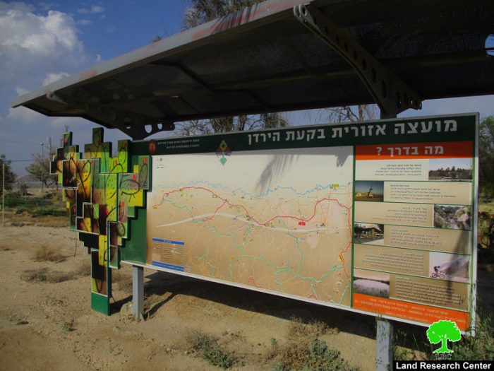
Photos 1-2: one signboard nearby Tomer colony, which indicates Hebrew names of places and touristic maps


About Palestinian Jordan Valley (Al-Ghour)

It should be marked that the Israeli occupation authorities declared in 1967 the area of Jordan Valley (1,024,722 dunums) as the eastern borders of Israel. Only 13,000 dunums are considered built-up area that is inhabited by 62, 876 people from 27 Palestinian communities divided as follows:

  • Northern Ghour (Tubas governorate): it includes several villages and towns namely Bardala, Ein Al-Beida, Atuf, Kardala, Al-Aqaba, Ibziq, Yarza, Al-Farisiya, Al-Maleh, Al-Ras Al-Ahmar and Humsa.
  • Middle Ghour ( Nablus governorate): it includes several villages and towns namely Al-Nasiriya, Al-Aqrabaniya, Beit Hasan and Ein Shibli.
  • Southern Ghour (Jericho governorate): it includes several towns and villages namely Marj Na'ja, Al-Jiftlik, Fasayil, Al-Auja, Al-Nuwei'ma, Ein AL-Duyuk, Ein Al-Sultan, Deir Al-Qilt, Aqabat Jabr, Deri Hajleh and Nabi Musa.

Also, the occupation took over more than 400,000 dunums from Al-Ghour lands and declared them military zone inaccessible for Palestinians. Any agricultural or residential activity in such area is banned. Not only, the occupation established 97 military zones and planted vast areas of dunums with landmines, imposing imminent threat on residents' lives.

According to a comparison study conducted by Land Research Center, lands designated for Palestinian construction in the Jordan valley doesn’t exceed 1% of the total area where Israel got a share of 3% for the colonization.


Prepared by
 The Land Research Center
LRC
 

Recommended For You

تصعيد إسرائيلي جديد: الاحتلال يهدم مبنى في بيت لحم ويواصل سياسة التطهير المكاني

by arij
August 12, 2025
0
تصعيد إسرائيلي جديد: الاحتلال يهدم مبنى في بيت لحم ويواصل سياسة التطهير المكاني

في استمرار لسياسة الهدم والتضييق التي تنتهجها سلطات الاحتلال الإسرائيلي بحق الفلسطينيين وممتلكاتهم، نفذت آليات وجرافات تابعة لقوات الاحتلال، صباح اليوم الأربعاء 6 آب 2025، عملية هدم واسعة...

Read moreDetails

Villages and Communities of Masafer Yatta: A Model of the Forced Displacement of Palestinian Communities in Area “C”

by arij
August 2, 2025
0
Villages and Communities of Masafer Yatta: A Model of the Forced Displacement of Palestinian Communities in Area “C”

Introduction: Since its occupation of the West Bank in 1967, Israel has pursued a long-term policy aimed at minimizing Palestinian presence in Area “C”, which constitutes approximately 61%...

Read moreDetails

قرى وتجمعات مسافر يطا: نموذج تهجير التجمعات الفلسطينية في المنطقة “ج” سياسة ممنهجة لاقتلاع الوجود الفلسطيني

by arij
August 6, 2025
0
قرى وتجمعات مسافر يطا: نموذج تهجير التجمعات الفلسطينية في المنطقة “ج” سياسة ممنهجة لاقتلاع الوجود الفلسطيني

مقدمة: منذ احتلالها للضفة الغربية عام 1967، تنتهج إسرائيل سياسة طويلة الأمد تهدف إلى تقليص الوجود الفلسطيني في المناطق المصنفة "ج"، التي تشكل ما نسبته 61% من الضفة...

Read moreDetails

قرية النعمان ضحية خطوة تهويديه أخرى: بلدية القدس الإسرائيلية تستهدف ديمغرافيا الوجود الفلسطيني

by arij
August 6, 2025
0

في خطوة تصعيدية جديدة ضمن سلسلة من الإجراءات التهويدية، أخطرت سلطات الاحتلال الإسرائيلي بتاريخ الثلاثين من تموز 2025 كافة منازل قرية النعمان الواقعة شمال شرق بيت لحم وجنوب...

Read moreDetails

Nu’man Village: A Victim of another Judaization Campaign

by arij
August 2, 2025
0
Nu’man Village: A Victim of another Judaization Campaign

In a new escalation within a systematic Judaization campaign, Israeli municipality of Jerusalem issued mass demolition orders on July 30, 2025, targeting all homes in the village of...

Read moreDetails
Next Post
إصدار خارطة تفصيلية بتحويل 45 دونماً في محيط البؤرة ” هيوفال” إلى مناطق عسكرية مغلقة

إصدار خارطة تفصيلية بتحويل 45 دونماً في محيط البؤرة " هيوفال" إلى مناطق عسكرية مغلقة

LATEST NEWS

” المواقع الأثرية في محافظة نابلس… ساحة مفتوحة أمام مخططات المصادرة الإسرائيلية “

” المواقع الأثرية في محافظة نابلس… ساحة مفتوحة أمام مخططات المصادرة الإسرائيلية “

by arij
August 21, 2025
0

........................................................

مشروع (E1): الضربة القاضية لحل الدولتين وإعادة تشكيل الخريطة الجيوسياسية للضفة الغربية

The Government Pushes Forward Plans in E1, Considered a Death Blow to the Two-State Solution

by arij
August 16, 2025
0

........................................................

مشروع (E1): الضربة القاضية لحل الدولتين وإعادة تشكيل الخريطة الجيوسياسية للضفة الغربية

مشروع (E1): الضربة القاضية لحل الدولتين وإعادة تشكيل الخريطة الجيوسياسية للضفة الغربية

by arij
August 16, 2025
0

........................................................

بواقع 86 أمرا عسكريا – الأوامر العسكرية الإسرائيلية, الأداة الرئيسية للاحتلال الاسرائيلي للسيطرة على المياه الفلسطينية في الضفة الغربية المحتلة

“سيطرة من تحت الأرض”, بواقع 108 أمرا عسكريا, سيطرة اسرائيلية على مياه الفلسطينيين في الضفة الغربية المحتلة

by arij
August 12, 2025
0

........................................................

flag_yellow_lowEU-PfP-Logo

This website has been produced with the assistance of the European Union. The contents of this publication are the sole responsibility of ARIJ & LRC and can in no way be taken to reflect the views of the European Union.

© 2025 Copyright ARIJ . All Rights reserved. .

No Result
View All Result
  • Home
  • Settlements
    • New Israeli Settlements
    • Settlement Expansion
  • Israeli Violations
    • Agriculture
    • Confiscation
    • Demolition
    • Environment
    • Eviction of Palestinians
    • Settlers Attacks
  • Bypass Roads
  • Israeli Plans
  • Segregation
    • Checkpoints
    • Closure
    • Separation Plans
  • Military Orders
  • Reports
    • Daily Report
    • Monthly Report
    • Quarterly Report

© 2025 Copyright ARIJ . All Rights reserved. .