• About The Project
  • Palestine in Century
  • Selected Maps
  • Glossary
  • About ARIJ
  • About LRC
  • By Year
    • Case Studies By Year
    • Daily Report By Year
Wednesday, July 2, 2025
POICA
No Result
View All Result
  • Home
  • Settlements
    • New Israeli Settlements
    • Settlement Expansion
  • Israeli Violations
    • Agriculture
    • Confiscation
    • Demolition
    • Environment
    • Eviction of Palestinians
    • Settlers Attacks
  • Bypass Roads
  • Israeli Plans
  • Segregation
    • Checkpoints
    • Closure
    • Separation Plans
  • Military Orders
  • Reports
    • Daily Report
    • Monthly Report
    • Quarterly Report
No Result
View All Result
POICA
No Result
View All Result

New master plan for Shvut Rahel colony at the expense of Nablus lands

May 11, 2017
in Settlement Expansion
مخطط لإقامة حي استعماري جديد  شرق مستعمرة ” شفوت راحيل”


  • Violation: depositing new master plan
  • Location:  Jalud village- Nablus  governorate
  • Date: February 17, 2017
  • Perpetrators: Planning and Construction Committee- Israel Civil Administration
  • Victims:  residents of Jalud

Details:

On February 17, 2017, Planning and Construction Committee- Israel Civil Administration featured an advertisement in Al-Quds Newspaper, stating the depositing of the new master plan number 1/3/205 for Shevut Rahel colony .

 According to the plan, the occupation transferred  some areas founded to the east of the colony  into construction areas. The plan included the establishment of governmental buildings and parks within a proposed neighborhood under the name of Shila.

It should be noted that the targeted location is founded within the natural blocks number 13 and 16 of Jalud lands, more specifically in the locations known as Khirbet Khneifis and Wad Al-Hawa.

Objectives of the plan:

  • Changing use of land from agricultural to urban
  • Determining the uses of lands
  • Delineating roads network
  • Specifying restrictions and instructions of construction within the plan
  • Specifying conditions and phases of development for the plan's implementers  

About the implications of the new plan, the chairman of Jalud village council, Abdallah Al-Hajj, said the following:

" The targeted area of Khneifis is considered archeological and has many Roman antiquities. The area extends on 600 dunums that the occupation classifies as state lands"


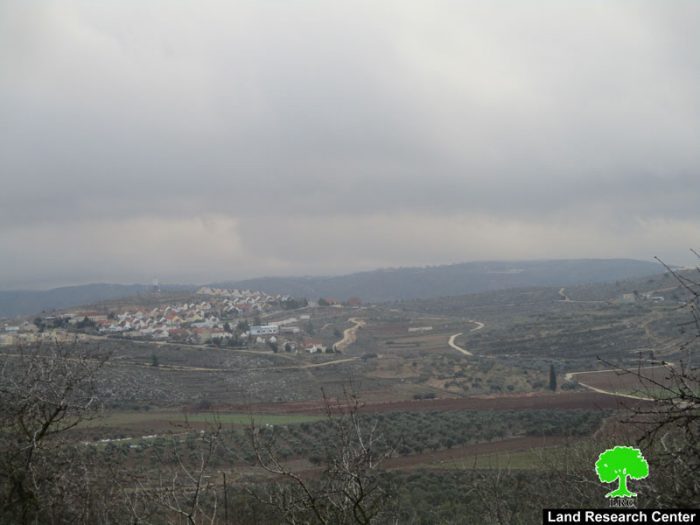
Photo 1: the targeted Palestinian location and view of Shevut Rahel colony


Photo 2: the plan's advertisement


Photo 3: a map for the new plan and an aerial photo illustrating the location


About Jalud:

Jalud  is located 29km to the southeast of Nablus city and is edged by Qusra village from the northeast,  Qaryut village from the west, Yesh Kodish and Ahya outposts  from the east and Shilo colony from the south.

Its population mounts up to 598 people (2014 census). Jalud's total land area is 22,473 dunums, of 80 dunums are considered the village's built-up area.

Israeli colonies confiscated 2227 dunums from Jalud lands. Shilo colony that was established in 1978 confiscated 640 dunums from the village. Mizpe Rahel colony and other outposts namely (Yesh Kodish, Ahya, Eli, Adi Ad and Kida) are founded on confiscated lands from the villg.

Bypass roads confiscated around 436 dunums from the village.

The lands of Marda are classified according to Oslo Accords as the following:

  • 5541 dunums (25%) are classified as area B
  • 16932 dunums (75%) are classified as area C


Prepared by
 The Land Research Center
LRC
 

Recommended For You

Expansion of Gilo Settlement: A Strategic Plan to Isolate Bethlehem and Undermine Palestinian Rights

by arij
May 12, 2025
0
Expansion of Gilo Settlement: A Strategic Plan to Isolate Bethlehem and Undermine Palestinian Rights

The Israeli Civil Administration has announced a new settlement expansion plan—No. 101-1284223—which outlines the construction of 1,990 new settlement units on approximately 175.9 dunums of land extending towards...

Read moreDetails

إسرائيل تمضي قدمًا في مخطط استيطاني جديد على أراضي مدينة بيت جالا، في انتهاك للقانون الدولي وحرمان الفلسطينيين من أراضيهم

by arij
April 29, 2025
0
Israel Advances Settlement Plan on Ancient Olive Groves on lands of Beit Jala city, Violating International Law and depriving Palestinians their lands

  في أواخر شهر شباط من العام 2025، صادقت دولة الاحتلال الإسرائيلي على مخطط استيطاني جديدة لبناء حي سكني للمستوطنين على مساحة 22.2 دونما من الأراضي الفلسطينية لتابعة...

Read moreDetails

سلطات الاحتلال الإسرائيلي تصادر 64 دونما شمال مدينة بيت لحم لإقامة موقفا للحافلات

by arij
October 19, 2023
0
سلطات الاحتلال الإسرائيلي تصادر 64 دونما شمال مدينة بيت لحم لإقامة موقفا للحافلات

  في السابع من شهر أيلول من العام 2023, صادقت بلدية الاحتلال الإسرائيلي في القدس المحتلة على مخطط استيطاني جديد من شأنه أن يصادر مساحات شاسعة من أراضي...

Read moreDetails

Israeli Settlements in the Occupied West Bank: from “outposts” to urban blocks

by arij
May 20, 2023
0
Israeli Settlements in the Occupied West Bank: from “outposts” to urban blocks

  The Applied Research Institute – Jerusalem (ARIJ) In cooperation with Palestine Economic Policy Research Institute (MAS)   Preface Legalizing nine Israeli settlement outposts in the occupied West...

Read moreDetails

استكمال انشاء حي استعماري تابع لمستعمرة ” الكانا” على أراضي قرية مسحة / محافظة سلفيت

by arij
November 1, 2022
0
استكمال انشاء حي استعماري تابع لمستعمرة ” الكانا” على أراضي قرية مسحة / محافظة سلفيت

  الانتهاك: توسع استيطاني. الموقع: قرية مسحة / محافظة سلفيت. تاريخ الانتهاك: تشرين أول 2022. الجهة المعتدية: مستعمرة " الكانا". الجهة المتضررة: أهالي قرية مسحة.  تفاضيل الانتهاك:   استكمل...

Read moreDetails
Next Post

ARIJ Daily Report – Sat, 18th 02 2017

LATEST NEWS

أمر عسكري إسرائيلي يستهدف أراضي قرية زبوبا الفلسطينية لأغراض أمنية مستعجلة

Israeli Order Targets Zububa Village Under Security Claims

by arij
June 24, 2025
0

........................................................

أمر عسكري إسرائيلي يستهدف أراضي قرية زبوبا الفلسطينية لأغراض أمنية مستعجلة

أمر عسكري إسرائيلي يستهدف أراضي قرية زبوبا الفلسطينية لأغراض أمنية مستعجلة

by arij
June 21, 2025
0

........................................................

At the Southeast Bethlehem Governorate: Al-Minya and Kisan Villages Caught Between Forced Displacement and Israel’s Expanding Settlement Plans

At the Southeast Bethlehem Governorate: Al-Minya and Kisan Villages Caught Between Forced Displacement and Israel’s Expanding Settlement Plans

by arij
June 21, 2025
0

........................................................

جنوب شرق بيت لحم: قرى المنيا وكيسان بين مطرقة التهجير وسندان مخطط التوسع الاستيطاني الإسرائيلي

جنوب شرق بيت لحم: قرى المنيا وكيسان بين مطرقة التهجير وسندان مخطط التوسع الاستيطاني الإسرائيلي

by arij
June 21, 2025
0

........................................................

flag_yellow_lowEU-PfP-Logo

This website has been produced with the assistance of the European Union. The contents of this publication are the sole responsibility of ARIJ & LRC and can in no way be taken to reflect the views of the European Union.

© 2025 Copyright ARIJ . All Rights reserved. .

No Result
View All Result
  • Home
  • Settlements
    • New Israeli Settlements
    • Settlement Expansion
  • Israeli Violations
    • Agriculture
    • Confiscation
    • Demolition
    • Environment
    • Eviction of Palestinians
    • Settlers Attacks
  • Bypass Roads
  • Israeli Plans
  • Segregation
    • Checkpoints
    • Closure
    • Separation Plans
  • Military Orders
  • Reports
    • Daily Report
    • Monthly Report
    • Quarterly Report

© 2025 Copyright ARIJ . All Rights reserved. .