A recent study conducted by the Applied Research Institute – Jerusalem (ARIJ) showed that Israel is on the move to establish new Industrial zones in various areas in the occupied West Bank (oWB). This policy constitutes a real danger in the area as more Palestinian land in the occupied West Bank is threatened of seizure and confiscation on the short run under that purpose. The study has revealed that Israel intends to establish 4 new Industrial zones in oWB, mainly in Jenin, Ramallah, Qalqilyia and Bethlehem, while expanding an existing buffer zone in Salfit Governorate. Below is a detailed description of each of the Industrial Zones:-
1- The Beitar Illit Industrial Zone
On the fourth of November 2014, the [1]Kikar news , a Hebrew–language Israeli news website revealed that a plan has been promoted for the establishment of a huge industrial park northwest of Beitar Illit settlement in Bethlehem Governorate. The industrial park, named “Hair Hanagli” of Beitar Illit "the English forest" of Beitar Illit, will occupy a huge area, of about 800 dunums on both sides of the Israeli Bypass Road No. 375, near the gas station and intends to create a future for the Beitar Illit Settlement by creating employment opportunities and provide commercial service for the settlers living in Beitar Illit and the settlements around and those inside the 1948 lands. According to the program, a significant part of the new industrial zone / park will contain huge shopping centers, such as BIG complex, banquet halls and events to serve residents of the settlement of Beitar Illit and the entire settlements in the area. Another part of the industrial zone / park will be assigned to the different needs for office buildings, including high-tech companies and major firms prefer to place, in order to save the high costs of Jerusalem. See Photo 1 below
A plan of the new Industrial park is attached below. Photo 2
2- The Shaked Industrial Zone
The Shaked settlement illegally established on lands of Jenin Governorate witnessed extensive expansion during 2016, where the Israeli bulldozers razed nearly 2 dunums of lands north of the settlement belonging to the village of ‘Anin in Jenin Governorate, with the intention to expand the settlement from its northern side for industrial uses. The targeted site is surrounded by settlements from almost all directions. It is bordered by the settlement of Tel Menashe from the northwest, the settlement of Hinanit from the northeast, the settlement of Shaked from the south, the community of Dahr Al Maleh and an Israeli military base nearby from the southwest. Additionally, another Industrial zone located to the east of Shaked settlement, namely Shahak-Shaked. This industrial zone occupies 203 dunums of Palestinian land. Israel is upholding its control over the land near the settlement through the establishment of new industrial zones in the area with no regard to the consequences of such an act on the nearby Palestinian communities. See Map 1
Map 1: Land reserved for industrial uses near Shaked settlement
The location of the razed land showed that the land targeted for industrial uses was classified by Israel as "Registered State Land"[2]. For more details, click here: Ecstasy vs. Siesta, "Israel Ecstatic vs. International Community Siesta & the Two-State Solution RIP"
3- The Barqan Industrial Zone
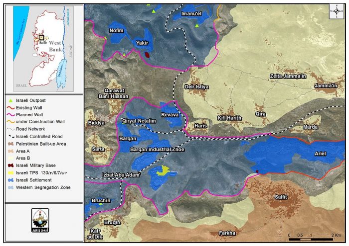
On the 4th of September 2016, the higher planning council at the Israeli civil Administration deposited a new town planning scheme (TPS) intended for the expansion of an industrial zone to the west of Ariel settlement, named “Barqan Industrial Zone” in Salfit Governorate. The TPS holds number יוש/ 7/ 6/ ת/ 130 and states the confiscation of 138.2 dunums of lands of Haris village in Salfit Governorate for that purpose . The targeted Industrial zone is actually surrounded by a set of Israeli settlements from almost all directions. It is bordered by Barqan, Netafim and Revava settlements from the north; Ariel settlement from the East, Bruchin settlement and the Palestinian village of Sarta from the West and an open area from the south.
The Barqan Industrial Zone was established in 1981 on lands of Haris, Burqin and Salfit communities in the Salfit Governorate. This industrial settlement is affiliated to what has become known today as the “Ariel settlement bloc”, a bloc of settlements that has been "strategically” built on a mountain ridge surrounded by Palestinian communities in Salfit Governorate. The bloc includes a number of settlements including Ariel (one of the largest settlements in the oPt), Revava, Qiryat Netafim, Barqan, and Barqan Industrial Zone in addition to a number of settlements that will become part of the bloc if Israel implements its unilateral separation plan in the area exemplified in the construction of the Segregation wall. See Map 2
Map 2: Expansion of Barqan Industrial Zone
4- The Meccabim Industrial Zone
In July 2016, the Israeli occupation authorities verbally notified Palestinian land owners in West Ramallah villages of their intention to confiscate land in the area to establish a new Industrial zone. A thorough analysis conducted by the Applied Research Institute – Jerusalem (ARIJ) of the targeted area revealed that on the 21st of June 2016, the director of planning at the Israeli ministry of finance has deposited Town Planning Scheme (TPS) No. יוש/ 230 which states the establishment of an industrial zone on lands of Saffa, Beit Sira and Beit Ur At Tahta villages, where the village of Saffa is the most targeted in terms of the area that is going to be confiscated from the village. Israel claims that the aim behind establishing the industrial zone is to create work opportunities in the area, as well for Palestinians; however, further analysis of the plan showed that Israel has previously declared the site intended for the Industrial Zone as “State land”, and hence trying to make use of that declaration to turn the area into an industrial and operational zone that will be run and operated in the future by the nearby Modi’in Illit settlement bloc. See Map 3
Map 3: The Meccabim Industrial Zone
5- The Elkana-Oranit Industrial Zone
On the 27th of January 2015, the Israeli daily newspaper, Haaretz, revealed about an investigation that revolves around 2400 dunums of Palestinian land in Qalqilyah Governorate that has been illegally transferred by some officials in the Israeli civil administration to an Israeli company (development of Samaria, Inc.) affiliated to Samaria “Shomron” Regional Council”. The transfer of land was made despite an order made by the head of the Israeli Civil Administration’s, Nitzan Alon, not to transfer these lands for the time being until a dispute between the Samaria “Shomron” Regional Council and the settlements of Elkana and Oranit over the control and management of the land in the future is resolved; not to mention the millions of shekels that this land will bring to whomever will manage it in the future from development fees and municipal taxes. See Map 4
Map 4: The Elkana Oranit Industrial Zone
Later on the 5th of January 2017, the Israeli ARUTZ7[3] website revealed that it was recently decided to establish a new industrial zone in occupied West Bank, named "Nachal Rabba – Sha'ar Shomron" Industrial Zone to be located near the settlements of Sha'arei Tikva and Oranit illegally established on lands of Qalqilyia Governorate. The new industrial zone, according to ARUTZ7 will be spread over 3,200 dunums of Palestinian land and is expected to accommodate advanced manufacturing factories and hi-tech. The industrial zone will be owned by the so-called “Samaria Regional Council, the Local Council of Oranit, and the Local Council of Elkana.” The promotion of the approval of establishing this new industrial zone was headed by Yossi Dagan, head of the so-called “Samaria Regional Council” in the occupied West Bank.
This latest Israeli declaration of establishing a new industrial zone will serve many goals amongst which are the following: (1) to consolidate the concept of constructing the wall in the area, as the new Industrial zone will be established in the area that has already become isolated west of the segregation Wall, in the area known today among Palestinians as “the western Segregation Zone”, between the 1949 Armistice Line and the line of the wall, bordering the Israeli settlement of Rosh Ha'ayin. (2) The establishment of this new Industrial zone will promote the expansion of more Palestinian land west of the wall and annexing it to Israel. (3) Israel will create more facts on the ground that would ultimately affect any final status outcome with the Palestinians. (4) Israel will ensure territorial contiguity between Israeli settlements in the Western Segregation Zone at the same time stop any natural expansion of Palestinians communities in the direction of settlements in the Western Segregation Zones. (5) Israel plans to preserve settlements’ sustainability with no regard to consequences on the nearby Palestinian communities. (6) and finally Israel wants to grab as much Palestinian land as possible for the future Israeli settlement plans.
To conclude,
There is a growing concern that settlement building and expansion will increase the fragmentation of the West Bank territory and endanger the possibility of a contiguous Palestinian state. Israel’s policy of approving building plans in settlements in the occupied Palestinian territory is one core issue of the conflict between Israelis and Palestinians. Israeli settlements are built on confiscated Palestinian land and contribute much to the displacement of Palestinians from their owned land and severely limit the Palestinian urban expansion and development. The Israeli Occupation practices in the occupied Palestinian territory constitute a breach to the various international law rules and norms, some of which are listed below
- The Fourth Geneva Convention states in Article 49 that “The occupying power shall not deport or transfer parts of its own population into the territories it occupies.” and Article 174 of the same convention “prohibits the 'extensive destruction and appropriation of property not justified by military necessity and carried out unlawfully and wantonly.”
- Article 33 of the Fourth Geneva Convention prohibits collective punishment, and land leveling and property destruction carried out by Israeli forces are collective punishments. The article states: 'No protected person may be punished for an offence he or she has not personally committed. Collective penalties and likewise all measures of intimidation or of terrorism are prohibited.”
- Article 147 of the convention considers 'extensive destruction and appropriate of property, not justified by military necessity and carried out unlawfully and wantonly' as a grave breach of the Convention and thus constitute a war crime.
- Article XXXI of the 1995 Oslo agreement Israel is forbidden from building or planning to any project or settlements or any colonial expansion or any plan that lead to change the status of the West Bank and Gaza Strip. The article provides “Neither side shall initiate or take any step that will change the status of the West Bank and the Gaza Strip pending the outcome of the permanent status negotiations”.
- Furthermore, the existence of the Israeli settlements in the West Bank and their expansions are Illegal and contradicts with the international law rules, United Nations Security Council Resolutions such as 237 (1967), 271 (1969), 446 (1979), 452 (1979) ,465 (1980.
- Resolution 446 March 22, 1979 calls on Israel to rescind its previous measures and to desist from taking any action which would result in changing the legal status and geographical nature and materially affecting the demographic composition of the Arab territories occupied since 1967, including Jerusalem and, in particular, not to transfer parts of its own civilian population into the occupied Arab territories"
- Also the resolution 452 of the 1979 “calls upon the Government and people of Israel to cease, on an urgent basis, the establishment, construction and planning of settlements in the Arab territories occupied since 1967, including Jerusalem.
[1] בדרך לעצמאות כלכלית: ביתר עילית מקימה אזור תעשייה
[2] When Israel occupied the West Bank in 1967, only one third of the occupied West Bank territory was registered to the people with a Turkish (Ottoman Empire) issued Tabo (certificate of ownership) and/ or with an official British certificate/ registration issued during the British Mandate era. Fundamentally, the Ottoman land code (law) of 1858 continue to govern the land holdings in the West Bank but was never so used during the centuries of Ottoman rule, or under the British and Jordanian rules who maintained the same law. Israeli Military Order #59 (1967(amended by M.O.1091)), which constituted an abuse of the Ottoman land law, by which the Israeli Military-appointed position of 'Custodian of Government Property' expropriated land owned by the Jordanian Government. Also, allows the 'Custodian of Government Property' to expropriate land from individuals or groups by declaring it 'Public Land' or 'State Land', the latter which it defines as land that was owned or managed by, or had a partner who was an enemy body or citizen of an enemy country during the 1967 war.
[3] Despite the boycott, business booming in Judea and Samaria
http://www.israelnationalnews.com/News/News.aspx/222819
Prepared By
The Applied Research Institute – Jerusalem
ARIJ


