Extensive expansion is ongoing near Shaked settlement in Jenin Governorate. The Israeli bulldozers have recently been razing lands north of Shaked Settlement belonging to the village of ‘Anin in Jenin Governorate. More than two dunums have been razed in the area with the intention to expand the settlement from its northern side for industrial uses.
The site, which is undergoing construction, is surrounded by settlements from almost all directions. It is bordered by the settlement of Tel Menashe from the northwest, the settlement of Hinanit from the northeast, the settlement of Shaked from the south, the community of Dahr Al Maleh and an Israeli military base nearby from the southwest. See Photos 1-3


Photos 1-3: ongoing expansion in Shaked settlement – Jenin Governorate

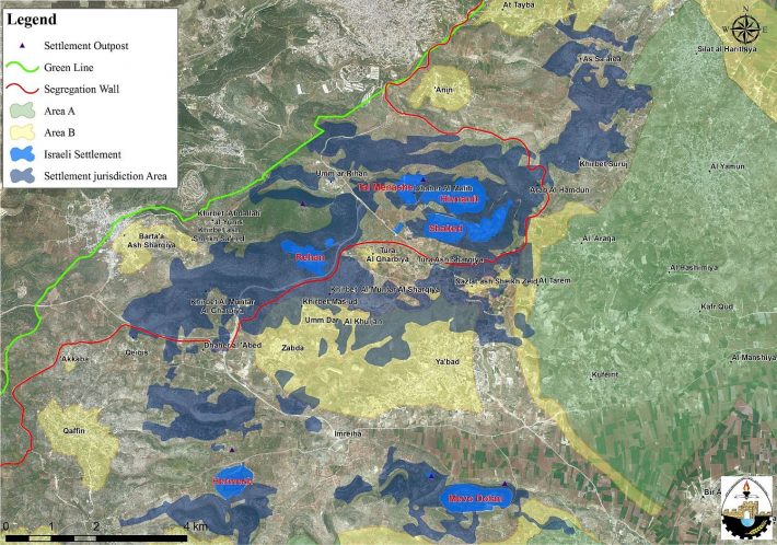
Map 1: The ongoing expansion in Shaked settlement
Further analysis of the location of the razed land showed that the land targeted for industrial uses was classified by Israel as "Registered State Land". When Israel occupied the West Bank in 1967, only one third of the occupied West Bank territory was registered to the people with a Turkish (Ottoman Empire) issued Tabo (certificate of ownership) and/ or with an official British certificate/ registration issued during the British Mandate era. Fundamentally, the Ottoman land code (law) of 1858 continue to govern the land holdings in the West Bank but was never so used during the centuries of Ottoman rule, or under the British and Jordanian rules who maintained the same law. Israeli Military Order #59 (1967(amended by M.O.1091)), which constituted an abuse of the Ottoman land law, by which the Israeli Military-appointed position of 'Custodian of Government Property' expropriated land owned by the Jordanian Government. Also, allows the 'Custodian of Government Property' to expropriate land from individuals or groups by declaring it 'Public Land' or 'State Land', the latter which it defines as land that was owned or managed by, or had a partner who was an enemy body or citizen of an enemy country during the 1967 war.
Accordingly, when Israel occupied the West Bank territory it assumed control of what was assigned as State Land at the time – during the Jordanian Administration period; an area of 634,920 dunums (11.2% from the total West Bank area) classified as “Registered State Lands”. For more details, click here: Ecstasy vs. Siesta, "Israel Ecstatic vs. International Community Siesta & the Two-State Solution RIP"
Shaked Settlement was established in 1981 on lands of ‘Anin village. Today, the settlement occupies a total land area of 950 dunums of Anin village and is home to more than 850 Israeli settlers. Throughout the years of the Israeli occupation, several Israeli plans were deposited in the settlement of Shaked with the intention to expand it. Table 1 gives details of the plans that were deposited in the settlement of Shaked since its establishment
|
Table 1: Israeli plans deposited for the building and expansion of Shaked settlement – Jenin Governorate |
||||
|
Plan Number |
Purpose |
Date of Publish |
Area targeted (dunums) |
Affected Community |
|
יוש/ 1/ 102 |
Neighborhood D |
5/6/1997 |
33.35 |
Ya'bad |
|
יוש/ 102 |
Detailed master plan settlement of Shaked |
2/3/1989 |
589 |
—- |
|
יוש/ 3/ 102 |
Change in the detailed master plan יוש/ 102 |
18/07/1999 |
181.28 |
—- |
|
יוש/ 4/ 102 |
Change in the detailed master plan יוש/ 103 |
19/07/1999 |
262 |
—- |
|
יוש/ 5/ 102 |
Change in the detailed master plan יוש/ 104 |
17/12/2012 |
122 |
Ya’bad |
|
Total |
|
|
||
|
Source: Israeli Ministry of Interior |
||||

Photo 1: Shaked Master Plan No. יוש/ 102

Photo 2: Israeli plan Number יוש/ 1/ 102

Photo 3: Israeli Plan No. יוש/ 3/ 102

Photo 4: Shaked Plan No. יוש/ 4/ 102

Photo 5: Israeli Plan No. יוש/ 5/ 102
Annexing the settlement of Shaked to Israel’s Proper
The latest revised map of the Israeli Segregation published on the so-called “ Israeli Ministry of Defense's” website in April 2007 showed that Israel intends to annex the settlement of Shaked inaddition to three others nearby, Hinanit, Tel Menashe and Rehan to Israel’s proper, by engulfing them in an area between the 1949 Armistice Line and the line of the Israeli Segregation Wall.
This area is also inhabited by thousands of Palestinians living in six Palestinian communities who became entrapped in what has become known today by “Barta’a enclave[1]” and barely have contact with the nearby Palestinian communities to their east (east of the wall). The six entrapped Palestinians communities are Barta'a Ash Sharqiya, Al Muntar Al Gharbi, Kh. Ash Shiekh Saed, Kherbit Abdullah Al Younis, Um Ar Riham, 'Arab Al Hamdoun, Kherbit Al Maleh and Barta'a Ash Sharqiya, (Map 2).

The Segregation Wall in Barta'a enclave extends for around 19 km, starting from 'Anin village near the 1949 Green Line (Armistice Line), then it extends to the east towards Arqa village cutting through its lands. It then stretches southeast towards Ya'bad and Barta'a villages where it isolates a considerable area of lands of the two villages and then continues towards Zabda village in the south where it isolates some of its lands within the enclave.
To sum up,
The Israeli confiscation and destruction of Palestinian land in the oPt contradicts with the international law rules mainly the Fourth Geneva Convention, Article 147 which clearly prohibits extensive destruction and appropriation of property, not justified by military necessity and carried out unlawfully and wantonly; and Article 49 of the Fourth Geneva Convention also states that: ‘Individual or mass forcible transfers, as well as deportations of protected persons from occupied territory to the territory of the Occupying Power or to that of any other country, occupied or not, are prohibited, regardless of their motive.‘ Violations of Articles of the Fourth Geneva Convention constitute breaches of the Convention and should be prosecuted as War Crimes.
Also Israel continues to violate its obligations as an occupying power under international law rules. The Israeli practices in the Palestinian territory clearly violate The International Covenant on Economic, Social and Cultural Rights (ICESCR) – Food (ICESCR, art. 11) which states that “the States Parties to the present Covenant recognize the right of everyone to an adequate standard of living for himself and his family, including adequate food, clothing and housing, and to the continuous improvement of living conditions. The States Parties will take appropriate steps to ensure the realization of this right, recognizing to this effect the essential importance of international co-operation based on free consent.”
Additionally, under Article XXXI of the Oslo II Interim agreement of 1995: Israel is forbidden from building or planning any project or settlements or any colonial expansion or any plan that leads to a change of the status of the West Bank and Gaza Strip. The article provides that “Neither side shall initiate or take any step that will change the status of the West Bank and the Gaza Strip pending the outcome of the permanent status negotiations”.
[1] Barta’a enclave, is part of the Western Segregation Zone, the area isolated between the 1949 Armistice Line and the line of the Israeli Segregation wall.
Prepared by:
The Applied Research Institute – Jerusalem


