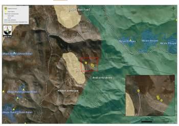
On the 25th and 26th of May 2016, the Israeli Civil Administration crews along with the Israeli Army stormed Abu Safi area at the eastern part of Duma village, south of Nablus city, and handed out stop construction orders that targeted a number of Palestinian houses and structures in the village.
The following table shows the details about the targeted houses and structures:
|
# |
Type of the targeted structures |
The owner |
|
1 |
Two-storey house |
Ali Sufian Dawabsha |
|
2 |
Two-storey house |
Sufian Ali Dawabshaq |
|
3 |
Two barracks and a room |
Abed Al Halem Riziq Dawabsha |
|
4 |
Two- storey house |
Marar family |
|
5 |
Three-storey house (400 square meters) |
Faqir Sari’a |
|
6 |
A barracks |
Abu Shadi Karshan |
|
7 |
A house |
Ahmed Abed Al Khaliq Dawabsha |
|
8 |
Electricity network (1 kilometer length) |
The council of Duma village |
|
9 |
Agricultural road (600 meters length) |
The council of Duma village |
Photocopies for the stop-construction orders
A geopolitical analysis conducted by the Geo-Informatics department in the Applied Research Institute- Jerusalem (ARIJ), showed that the targeted houses and structures in addition to the agricultural road located in the area classified as “Area C” (According to Oslo Agreement, 1995), which it under the control of the Israeli Authorities, where the Palestinians living in Area C (about 60% of the total area of the West Bank) need to get the building permits from the Israeli Civil Administration. See the map below:
Moreover ,and according to the analysis of the new military orders that targeted houses and structures in Duma village, the only purpose for these orders is to stop the expansion and the development of the Palestinians in their lands, where there is no settlements, outposts or military bases nearby the area of Abu Safi neighborhood, at the eastern part of Duma village.
Duma village:
Duma is a Palestinian village in Nablus Governorate, located southeast of Nablus City. It is bordered by Al Jiftlik and Fasayil (in Jericho Governorate) to the east, Majdal Bani Fadil to the north, Qusra and Jalud to the west, and Al Mughayyir (in Ramallah Governorate) to the south.
Geopolitical status in Duma village
According to the Oslo II Interim Agreement signed on 28th September 1995 by the Palestinian Liberation Organization (PLO) and Israel, Duma was divided into Area B and Area C. Approximately 953 dunums (5% of the total area of Duma village) were classified as Area B, where the Palestinian National Authority (PNA) has complete control over civil matters but Israel continues to retain overriding responsibility for security. The rest of the village’s area, constituting 17,365 dunums (95% of the total area), was classified as Area C, where Israel retains full control over security and administration related to the territory. In Area C, Palestinian building and land management is prohibited unless through consent or authorization by the Israeli Civil Administration. The majority of Duma’s population resides in Area B while most of the land lying within Area C is agricultural land and open space.
Israeli Colonial practices in Duma village
Despite the fact that there are no current settlements and camps established on Duma village lands, the village still suffers from Israeli occupation practices and human rights violations; settlements, camps and Israeli military checkpoints still exist not far from the village. Israeli settlements surround the village from the western and eastern sides. "Shvut Rachel" settlement and the settlement outposts of "Adei Ad", "Esh Kodesh" and "Ahiya" are situated to the west of Duma, built on land belonging to the neighboring villages of Qusra and Jalud. "Ma'ale Efrayim" and "Peza'el" settlements surround Duma from the eastern side. These two settlements are established on land belonging to Al Jiftlik and Fasayil villages in Jericho Governorate.
For more information about Duma village:
http://vprofile.arij.org/nablus/pdfs/vprofile/Duma_vp_en.pdf
Prepared By
The Applied Research Institute – Jerusalem
ARIJ


