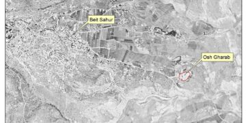
The Israeli daily newspaper “Haaretz” reported on the 7th of May 2016, that the so called “Israeli Ministry of Defense” jointly with the “Amana” settlement movement are planning to build a new settlement in the occupied West Bank (oWB). The planned settlement is to be built on a hilltop east of Shilo settlement in Nablus Governorate and it would accommodate Israeli settlers currently living in Amona[1] settlement outpost, which is slated for evacuation by the end of the year 2016.
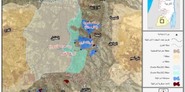
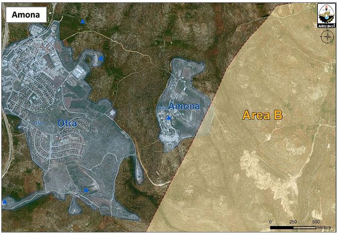
Haaretz reported that the planned settlement is intended to include 139 new settlement units for 40 Settlers’ families living in the Amona outpost (around 50 mobile homes). Note that land slated for the construction of the new settlement is declared by Israel as “State Land”[2] where Israel assumes control over such land classification in the occupied Palestinian territory. See Map 1

Map 1: location of the planned settlement
Declaration of Palestinian Land as “State Land”
In 1967, Israel occupied the Palestinian territory (the West Bank including East Jerusalem and the Gaza Strip). By that time, only one third of the whole West Bank land had been properly registered in the Jordanian Land Register and this land was registered to the Palestinian people with a Turkish issued Taboo (so called under the Ottoman Empire- as certificate of ownership) and/ or with an official British certificate/ registration issued during the British Mandate era.
Fundamentally, the Ottoman land code (law) of 1858 continue to govern the land holdings in the West Bank before 1967 but was never so used during the centuries of Ottoman rule, or under the British and Jordanian rules who maintained the same law.
When Israel occupied the Palestinian territory, it issued military order Number 59[3] (of 1967 (amended by M.O.1091[4])), which constituted an abuse of the Ottoman land law, by which the Israeli Military-appointed position of 'Custodian of Government Property' expropriated land owned by the Jordanian Government. Additionally, the military order also allowed the 'Custodian of Government Property' to expropriate land from individuals or groups by declaring it 'Public Land' or 'State Land', the latter which it defines as land that was owned or managed by, or had a partner who was an enemy body or citizen of an enemy country during the 1967 war[5].
Israel is heading towards the formation of a new settlement bloc in the occupied West Bank
As more Palestinian land is taken for new settlement building and expansion, less land is available for future Palestinian development. Additionally, as settlement building and expansion continues, there is growing concern that the increasing fragmentation of the West Bank territory will endanger the possibility of a contiguous Palestinian state in the future;
The case of Shilo settlement and the planned nearby building will maintain an Israeli territorial contiguity in the area and consequently form a new settlement bloc that would entirely obstruct the development of nearby Palestinian communities in the future.
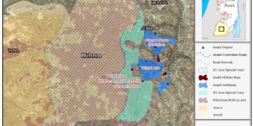
Moreover, in October 2015, and in response to a petition filed by Yesh Din, an Israeli human rights organization, requesting the evacuation of 16 buildings found to be built on Private Palestinian land in the illegal outpost of Adei Ad, to the east of Shilo settlement, the State of Israel announced that it intends to authorize a bloc of four settlement outposts in the area of Shilo settlement. The outposts were identified as Adei Ad, Kida, Esh Kodesh and Ahiya. This declaration will dramatically affect the future of the area since the whole Palestinian land located in between, will become under the threat of confiscation for future settlement expansion and development[6], See Map 2

To Conclude,
The Israeli annexation of Palestinian land is illegal as stated in many international laws and many United Nations Security Council resolutions, one of which is the United Nations Security Council Resolution 452 which 'calls upon the Government and people of Israel to cease, on an urgent basis, the establishment, construction and planning of settlements in the Arab territories occupied since 1967, including Jerusalem.'
Article 49 of the Fourth Geneva Convention also states that 'The occupying power shall not deport or transfer parts of its own population into the territories it occupies’; as well as Article 174 of the same convention also prohibits the 'extensive destruction and appropriation of property not justified by military necessity and carried out unlawfully and wantonly.'
[1] Amona outpost was established in 1997
[2] when Israel occupied the West Bank territory it assumed control of what was assigned as State Land at the time – during the Jordanian Administration period; an area of 634,920 dunums (11.2% from the total West Bank area) classified as “Registered State Lands”, where according to the Israeli equivocal interpretation to the laws, Israel consider itself the legitimate heir of the Jordanian, the British Mandate, the Ottoman; respectively State Land after its military occupation to the Palestinian territory in June 1967, which is absolutely erroneous. For more information, click here: Ecstasy vs. Siesta
Israel Ecstatic vs. International Community Siesta & the Two-State Solution RIP
[3] [1] Military Order #59 (1967?) – http://www.israellawresourcecenter.org/israelmilitaryorders/essays/israelimilitaryordersessay.htm
[4] LAW TYPE: MILITARY ORDER
LAW NUMBER: 1091
DATE: 20 January 1984
LAW NAME: ORDER CONCERNING STATE PROPERTY
AMENDS: Military Order 59
LAW SUMMARY: 'State property' is now interpreted as including any property subject to an expropriation order. It is defined as: (1) 'Property that on the date of occupation or afterwards was registered in the name of an enemy state, or any organization or company linked or controlled directly or indirectly by a hostile state'. (2) 'Land that has been confiscated in the public interest in accordance with legislation or security legislation through or for one of the sectors/ authorities of the Israeli military forces which is not necessarily local'. (3)' All property which belongs to individuals who have requested that the official authorities administers and manages their properties, and which the official has consented to administer.'
[5] “Towards Sustainable Occupation”, Four Illegal Outposts to be Legalized
http://www.old.poica.org/details.php?Article=8493
Prepared by:
The Applied Research Institute – Jerusalem