• About The Project
  • Palestine in Century
  • Selected Maps
  • Glossary
  • About ARIJ
  • About LRC
  • By Year
    • Case Studies By Year
    • Daily Report By Year
Tuesday, October 7, 2025
POICA
No Result
View All Result
  • Home
  • Settlements
    • New Israeli Settlements
    • Settlement Expansion
  • Israeli Violations
    • Agriculture
    • Confiscation
    • Demolition
    • Environment
    • Eviction of Palestinians
    • Settlers Attacks
  • Bypass Roads
  • Israeli Plans
  • Segregation
    • Checkpoints
    • Closure
    • Separation Plans
  • Military Orders
  • Reports
    • Daily Report
    • Monthly Report
    • Quarterly Report
No Result
View All Result
POICA
No Result
View All Result

Israel to transform 2202.7 dunums from Salfit into “State Lands”

July 18, 2016
in Military Orders
Israel to transform 2202.7 dunums from Salfit into “State Lands”
  • Violation: declaring 2202.7 dunums as "state lands"
  • Location: villages of south Nablus
  • Date:  March 08, 2016
  • Perpetrators: Israel Civil Administration
  • Victims:  owners of lands

Details:

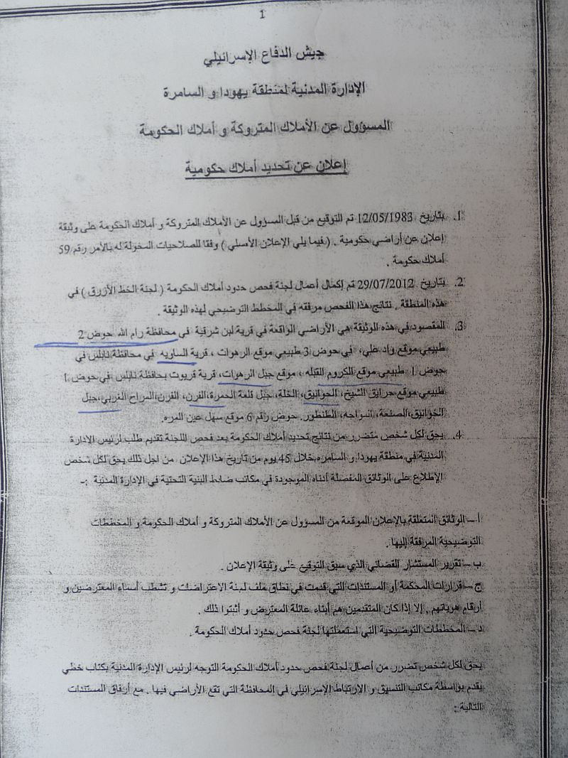
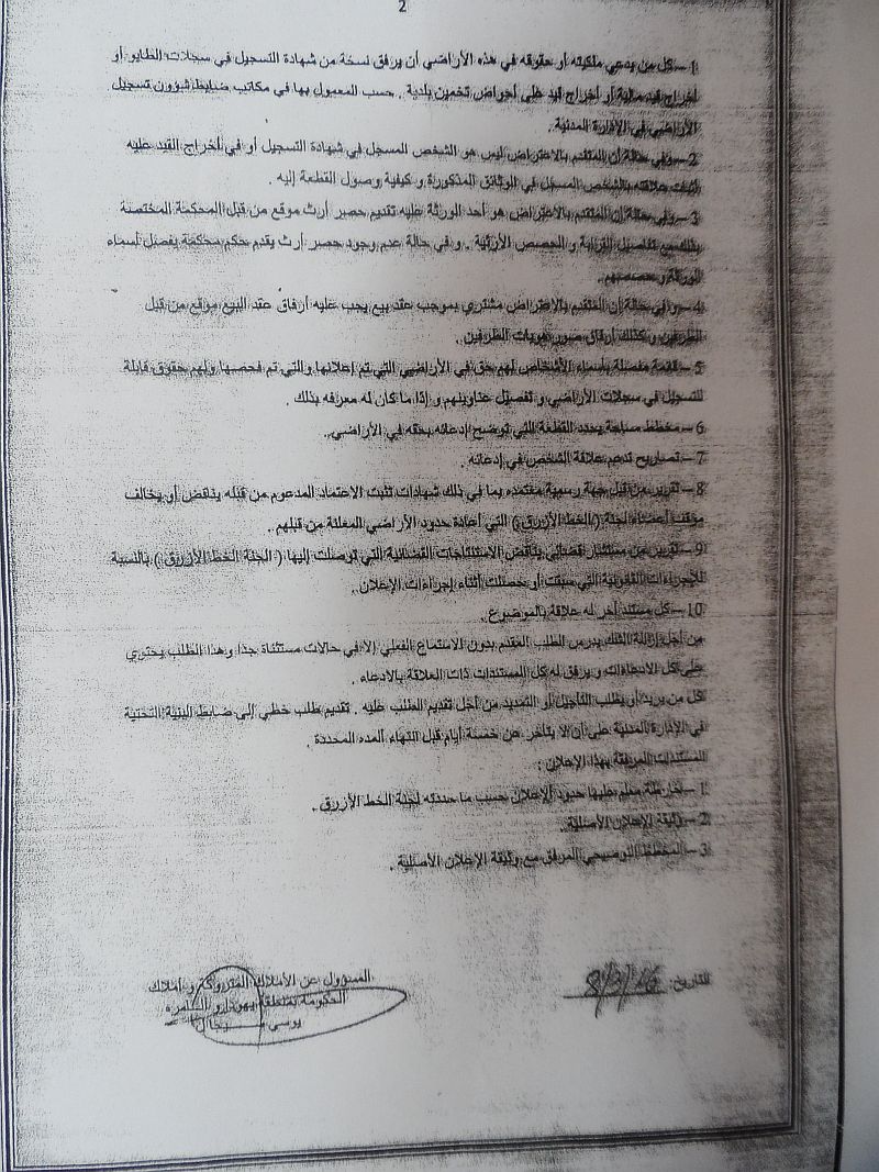
The so-called Israel Civil Administration, through the responsible of State Properties, issued on March 08, 2016 a military order declaring 2202.7 agricultural dunums from Al-Sawiya, A;-Lubban Al-Sharqiya and Qaryut villages as State Lands that are to be used for the occupational ends.

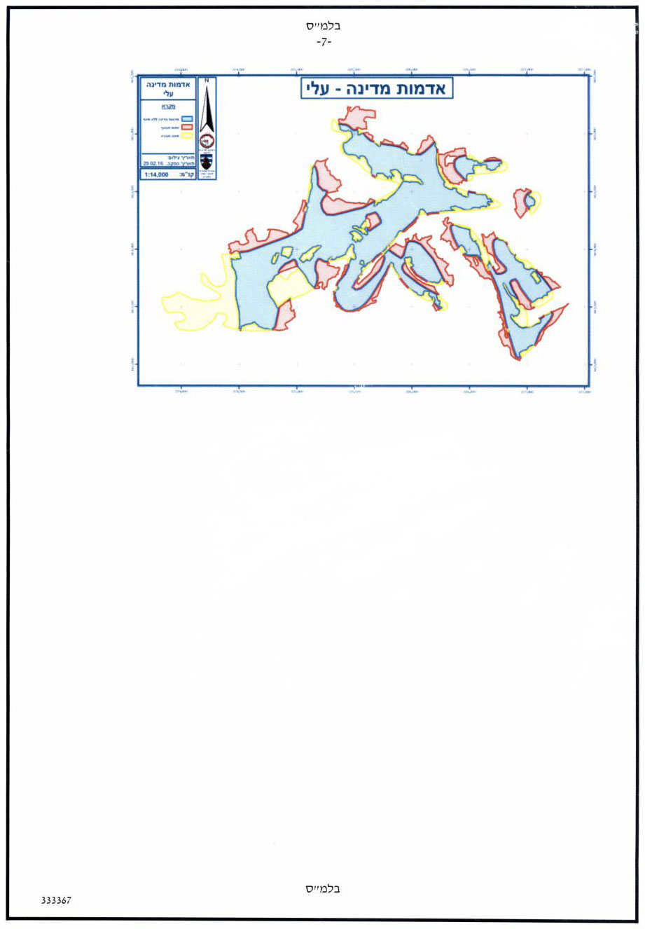
According to the maps attached to the order, the seized area extends alongside Eli colony and its periphery.

1 2 3


Photos 1-3: the military order and attached maps

4

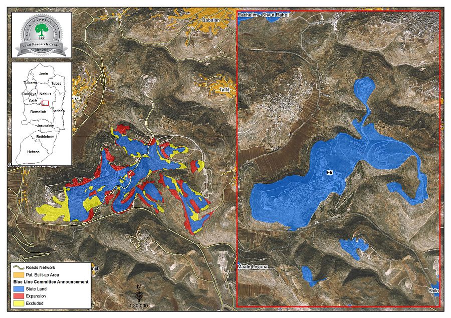
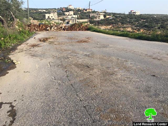
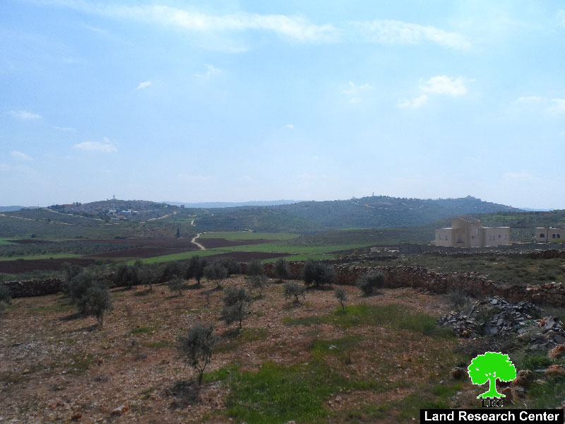
Photo 4: an aerial photo of the confiscated locations

56

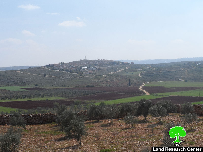
Photos 5-6: Shilo and Eli colonies' expansion to connect one to the other


The following table shows information about the confiscation locations :

Village

Area\dunum

State Lands\ dunum

Expansion\ dunum

Excluded lands\ dunum

No. of natural block

Specific location

Al-Sawiya

894.4

701

193.4

77.3

Number one

Al-Rahawat and Kurum Al-Qabliya

Al-Lubban Al-Sharqiya

602.6

425.8

176.8

309.9

Number two, three and one

Wad Ali, Al-Rahawat and Kurum Al-Qabliya

Qaryut

705.7

463.7

242

192.9

Number one and six

Harayiq Al-Shaikh, Al-Khawaniq, Al-Khalleh, Qal'it Al-Hamra, Al-Forn, Al-Marah Al-Gharbi, Habil Al-Khawaniq, Al-San'a , Al-Sawaja and Al-Tantur

Total

2202.7

1590.5

612.2

580.1


According to the Geographical Information System department at Land Research Center, the lands declared seized by the order totaled 2202.7 dunums. On May 12, 1983, the area was declared as State Lands. Later on, 612.2 dunums were annexed to it. Not only, an extension on a confiscation validity was made for 1590.5 dunums.  All the aforementioned numbers total the currently declared number of 2202.7 dunums. Noteworthy, the order excluded around 580.1 dunums.

It should be marked that part of the targeted lands is owned by Palestinian farmers and is still used while the bigger part was confiscated years ago to build Eli colony, which is rapidly expanding on the lands of the aforementioned villages. Original owners of those lands are banned from entering and even using their own property.

The responsible of the colonization file, on the implications of the situation, told Land Research Center the following:" This plan could separate the northern part of the West Bank from its southern one through establishing a colonial bloc of settlements in the heart of the west Bank; especially after knowing that this step opens the door for colonial expansion in random places, not mentioning the ratification of Eli master plan, which included connecting the colony with others in the nearby".

He also added: " Taking over the area of archeological site of Silon and declaring it State Land is an international crime; especially after changing landmarks, conducting excavations and investing millions of Shekels to expand the area to make a touristic resort"

It should be marked that the confiscation occurred in synchronization with a similar incident of 2400 dunums seizure in the area of Dead Sea.

It is known that the Israeli occupation, since 1948, has been using fraud methods to seize and take over Palestinian lands and properties. A major method is by declaring lands as State Property ,Property of Absentees  and closed military zones. This how the occupation serves advancement of  the colonial plan in the West Bank.


Prepared by
 The Land Research Center
LRC


Tags: Eli settlementsIsraeli Civil AdministrationMilitary OrderState Land

Recommended For You

سلطات الاحتلال الإسرائيلي تستغل ‘المنفعة العامة’ لنهب الموارد الفلسطينية

by arij
September 30, 2025
0
سلطات الاحتلال الإسرائيلي تستغل ‘المنفعة العامة’ لنهب الموارد الفلسطينية

في الاول من شهر ايلول من العام 2025، نشرت الإدارة المدنية الإسرائيلية، الذراع الأيمن لحكومة الاحتلال الإسرائيلي أمرا عسكريا جديدا تحت عنوان " أمر ءبشأن قانون الأراضي (الاستملاك...

Read moreDetails

The Occupation Targets the Village of Raba Southeast of Jenin with Military Orders and Seizes Vast Areas of Its Lands

by arij
September 13, 2025
0
الاحتلال يستهدف بأوامر عسكرية قرية رابا جنوب شرق جنين ويصادر مساحات واسعة من أراضيها

 The Israeli occupation Army have continued their policy of plundering Palestinian lands, as their bulldozers leveled wide areas of agricultural land in the village of Raba, southeast of...

Read moreDetails

الاحتلال يستهدف بأوامر عسكرية قرية رابا جنوب شرق جنين ويصادر مساحات واسعة من أراضيها

by arij
September 13, 2025
0
الاحتلال يستهدف بأوامر عسكرية قرية رابا جنوب شرق جنين ويصادر مساحات واسعة من أراضيها

  واصلت قوات الاحتلال الإسرائيلي سياسة نهب الأراضي الفلسطينية، حيث أقدمت آلياتها على تجريف أراض زراعية واسعة في قرية رابا جنوب شرق محافظة جنين، تمهيدا لشق شارع عسكري...

Read moreDetails

Nablus Governorate’s Archaeological Sites Face Israeli Expropriation Plans

by arij
September 11, 2025
0
” المواقع الأثرية في محافظة نابلس… ساحة مفتوحة أمام مخططات المصادرة الإسرائيلية “

On 10 August, 2025, the Israeli Civil Administration (ICA), issued a booklet of military orders signed by the head of the so-called ‘Israeli Civil Administration’ in the occupied...

Read moreDetails

” المواقع الأثرية في محافظة نابلس… ساحة مفتوحة أمام مخططات المصادرة الإسرائيلية “

by arij
August 26, 2025
0
” المواقع الأثرية في محافظة نابلس… ساحة مفتوحة أمام مخططات المصادرة الإسرائيلية “

في العاشر من شهر اب من العام 2025, أصدرت الإدارة المدنية الإسرائيلية كراسة أوامر عسكرية موقعة من قبل رئيس ما يسمى "بالإدارة المدنية الإسرائيلية" في الضفة الغربية المحتلة,...

Read moreDetails
Next Post
Israeli Occupation Forces seal off the entrance of Hejjeh village

Israeli Occupation Forces seal off the entrance of Hejjeh village

LATEST NEWS

Annexation of the Jordan Valley: Implications for the Two-State Solution and Regional Stability

Annexation of the Jordan Valley: Implications for the Two-State Solution and Regional Stability

by arij
September 29, 2025
0

........................................................

Isolation of Three Villages Northwest of Jerusalem: Silent Annexation Creeps toward the Capital

عزل ثلاث قرى فلسطينية شمال غرب مدينة القدس: الضم الاسرائيلي الصامت يزحف نحو محيط العاصمة

by arij
September 24, 2025
0

........................................................

Isolation of Three Villages Northwest of Jerusalem: Silent Annexation Creeps toward the Capital

Isolation of Three Villages Northwest of Jerusalem: Silent Annexation Creeps toward the Capital

by arij
September 24, 2025
0

........................................................

سياسات التهويد في القدس: من السيطرة المكانية إلى طمس الهوية عبر التسمية

سياسات التهويد في القدس: من السيطرة المكانية إلى طمس الهوية عبر التسمية

by arij
September 23, 2025
0

........................................................

flag_yellow_lowEU-PfP-Logo

This website and its content were initiated in 1993 by the Applied Research Institute – Jerusalem (ARIJ) and the Land Research Center (LRC) with the support from the European Union up until 2023. Since then, the Applied Research Institute – Jerusalem (ARIJ) has taken over the continued development and maintenance of the website. The views expressed remain solely those of ARIJ) and do not necessarily reflect those of the European Union.

© 2025 Copyright ARIJ . All Rights reserved. .

No Result
View All Result
  • Home
  • Settlements
    • New Israeli Settlements
    • Settlement Expansion
  • Israeli Violations
    • Agriculture
    • Confiscation
    • Demolition
    • Environment
    • Eviction of Palestinians
    • Settlers Attacks
  • Bypass Roads
  • Israeli Plans
  • Segregation
    • Checkpoints
    • Closure
    • Separation Plans
  • Military Orders
  • Reports
    • Daily Report
    • Monthly Report
    • Quarterly Report

© 2025 Copyright ARIJ . All Rights reserved. .