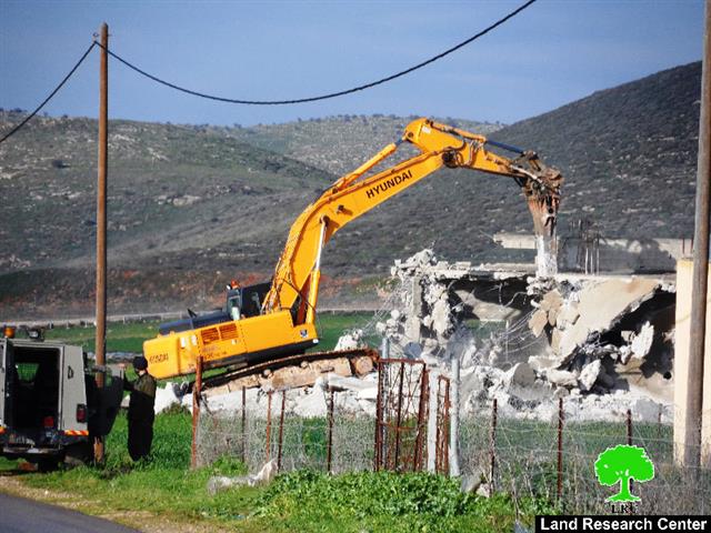
On January 12, 2016 the Israeli Occupation Army handed over Palestinian residents from Khirbet Al Marajem east of the village of Duma in Nablus Governorate military demolition orders for their eight houses and structures under the pretext of lacking building permits.
The owners of the threatened houses and structures are: Mr. ‘Oda Hasan Mohammad Faraj (1 residential structures), Mousa Mohammad Salman Musallam ( 6 structures of which 2 residential )and Hisham Mohammad ( 1 residential building).
Photo copies for part of the Demolition Orders in khirbet Al Marajem
It is worth mentioning that on July 14 , 2015, two Palestinian families from Khirbet Al Marajem received a demolition order for their houses under the pretext of lacking building permits.
Khirbet Al Marajem is a small Palestinian community adjacent to Duma village southeast of Nablus Governorate. It is bordered by Duma village from the north, the settlement of Ma’aleh Efraym from the northeast ,Israeli military base from the south , Shuvut Rahel and Shilo settlements from the west and the eastern Segregation Zone via Jordan Valley from the east. See the map below:
Khirbet El Marajem southeast of Nablus
Duma is a Palestinian village in Nablus Governorate, located 20.3 km southeast of Nablus City. It is bordered by Al Jiftlik and Fasayil to the east, Majdal Bani Fadil to the north, Qusra and Jalud to the west, and Al Mughayyir to the south.
The total area of Duma village consists of approximately 113311 dunums. This is according to the new borders of the local bodies which was stipulated by the Palestinian Ministry of local government, prepared by the Palestinian National Authority and represented by the Ministry of Local Government, the Central Elections Commission, the Ministry of Planning and the Palestinian Central Bureau of Statistics 2011.
According to the Palestinian Central Bureau of Statistics (PCBS) 2016 projections, the total population of Duma is 2547 residents.
Geopolitical Status in Duma Village
According to the Oslo II Interim Agreement signed on 28th September 1995 by the Palestinian Liberation Organization (PLO) and Israel, Duma was divided into Area B and Area C. Approximately 953 dunums (5% of the village’s total area) were classified as Area B, where the PNA has complete control over civil matters but Israel continues to retain overriding responsibility for security. The rest of the village’s area, constituting 17,365 dunums (95% of the total area), was classified as Area C, where Israel retains full control over security and administration related to the territory. In Area C, Palestinian building and land management is prohibited unless through consent or authorization by the Israeli Civil Administration. The majority of Duma’s population resides in Area B while most of the land lying within Area C are an agricultural land and open space.
|
Geopolitical Division of Duma According to Olso II Agreement of 1995 |
||
|
Area Classification |
Area- Dunums |
% from the village Area |
|
Area A |
0 |
0 |
|
Area B |
953 |
5 |
|
Area C |
17365 |
95 |
|
Total |
18318 |
100 |
|
Source: ARIJ Geo- informatics Department – 2016 |
||
Israeli Colonial Activities in Duma
Israeli occupation practices in Duma village Despite the fact that there are no current settlements and camps established on Duma village lands, the village still suffers from Israeli occupation practices and human rights violations; settlements, camps and Israeli military checkpoints still exist not far from the village. Israeli settlements surround the village from the western and eastern sides. "Shvut Rachel" settlement and the settlement outposts of "Adei Ad", "Esh Kodesh" and "Ahiya" are situated to the west of Duma, built on land belonging to the neighboring villages of Qasra and Jalud. "Ma'ale Efrayim" and "Peza'el" settlements surround Duma from the eastern side. These two settlements are established on Palestinian Localities Study Nablus Governorate 15 land belonging to Al Jiftlik and Fasayil villages. These settlements infringe upon residents’ rights relating to their land and property. There are three military bases which surround the village from the eastern, western and southern sides. Such military bases are situated deep inside Palestinian territory in order to boost the Israeli military presence and maintain tight control over the Palestinian population, and are often the source of human rights violations against Palestinians. According to information provided by Duma Village Council, Israeli occupation authorities control more than 10,000 dunums of the eastern side of the village under the pretext that it is a preserved natural area. Pastoralists and farmers are prevented from accessing the land or use it for grazing or agriculture or any other purposes.
6 Military Expropriation Orders to Install Observation Military Towers East of the city of Nablus
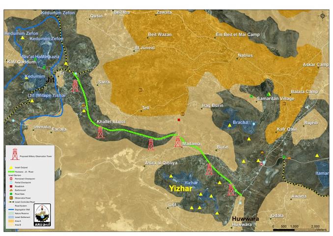
On January 12, 2016, the Israeli Occupation Army handed over the Palestinian authorities six military orders to confiscate 643 m 2 to install military observation towers on the road links between Huwwara and Jit Palestinian towns south and southwest of Nablus Governorates. See the map and confiscation orders below:
The proposed six observation towers to be installed on Huwwara-
Photocopies for the confiscation orders to Install 6 Observation Towers
Jit Road
The confiscation orders signed by lieutenant colonel “Avi’ad Kessfi Zelberman , the head of “Infrastructure Department” in the Israeli Civil Administration . The military orders holding numbers: (1/15/ -5776 Judea & Samira ) (2/15 / -5776 Judea & Samira) ( 3/15 -5776 Judea & Samira) (4/15 -5776 Judea & Samira) (5/15 -5776 Judea & Samira) (6/15 -5776 Judea & Samira).
On the ground , the consequences of the confiscation of the aforementioned lands exceeds the construction of six military observation towers, where thousands of dunums of Palestinian private-owned land located nearby the sites of the proposed towers will be isolated and their owners will no longer be able to cultivate or reach their land.
Prepared by
The Applied Research Institute – Jerusalem


