• About The Project
  • Palestine in Century
  • Selected Maps
  • Glossary
  • About ARIJ
  • About LRC
  • By Year
    • Case Studies By Year
    • Daily Report By Year
Sunday, May 11, 2025
POICA
No Result
View All Result
  • Home
  • Settlements
    • New Israeli Settlements
    • Settlement Expansion
  • Israeli Violations
    • Agriculture
    • Confiscation
    • Demolition
    • Environment
    • Eviction of Palestinians
    • Settlers Attacks
  • Bypass Roads
  • Israeli Plans
  • Segregation
    • Checkpoints
    • Closure
    • Separation Plans
  • Military Orders
  • Reports
    • Daily Report
    • Monthly Report
    • Quarterly Report
No Result
View All Result
POICA
No Result
View All Result

“Mordot Ramot”
A unique Green area to be replaced by a colonial neighborhood

December 4, 2015
in New Israeli Settlements
“Mordot Ramot”  A unique Green area to be replaced by a colonial neighborhood


On the 11th of November 2015, the Israeli news website, Yedi’ot Ahranot, revealed on its Hebrew website that the National Committee for Housing-Preferential Zones in Jerusalem, an entity which has the authority to approve most types of local outlines and plans in Jerusalem city, approved the construction of 1638 new settlement units in a Green area near Ramot settlement in Jerusalem despite oppositions made by the Israeli Jerusalem Municipality and the Israeli Ministry of Environment.  

The targeted Green area is called “Mitzpe Naftuh” and is located in close proximity of Ramot settlement, to its south and southeast. The plan will be deposited for Public Review who will be given 60 days to file objections on the plan. Note that this step is the last before approving the plan, after which, building permits and tenders may be issued at any time.

Earlier in June, 2015 the Israeli ministry of Housing and construction gave a fast-track approval of Mitzpe Naftuh construction plan in Jerusalem city. The plan was labeled as “a priority area for the construction of new housing” and was sent to “the Israeli national planning and building committee” that deals with approved priority sites and has the power to overrule any requirements of the approved plan.

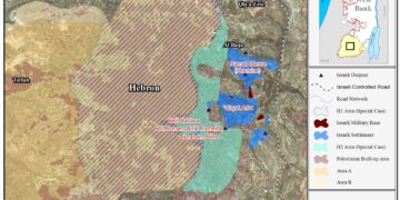
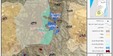
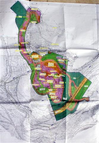
A thorough analysis of the Mitzpe Naftuh plan showed that part of the project is going to be implemented beyond the 1949 Armistice line (Green Line), on lands of Beit Iksa village northwest of Jerusalem city. The plan of Mitzpe Naftuh holds number 6885[1] and covers an area of 417 dunums. The new neighborhood plan includes a 7-11 story buildings in addition to other urban structures such as commercial buildings, housing facilities, schools and public institutions. 41% of the total area of the project is designated as open spaces and forests. See Map 1

The plan of Mitzpe Naftuh in Jerusalem


For so long, has this area been designated as Green Area in Jerusalem and Palestinians were denied access/permission to utilize it under any circumstances. This type of “land designation” in Jerusalem has always been used by the Israeli Authorities to hinder the Palestinian urban development in the city, at the sme time, maintain this area for future settlement construction. The case usually takes a different direction if the land designated as “Green Area”, is required for settlement construction and this is the case of Mitzpe Naftuh Green Area.

Another example of rezoning lands in Jerusalem city is the Reches shu’fat settlement in occupied East Jerusalem. Part of the land where Reches Shu’fat settlement sits today was actually zoned as a Green area; but was later rezoned for settlement construction. The Jabal Abu Ghneim[2] (Abu Ghneim Mountain) south of Jerusalem and north of Bethlehem was rezoned in the mid-nineties from “Green Area”” to urban building”; today, a huge settlement sits on top of Abu Ghuneim mountain and is considered the fourth largest settlement in Bethlehem Governorate.

Beit Iksa Village and Israeli Occupation Practices

Hundreds of dunums of land have been confiscated from the village of Biet Iksa by Israeli authorities mainly for the construction and expansion of settlements and the construction of the Segregation Wall, through which Israel aims to annex the three major settlement blocs around Jerusalem city to its proper, while encircling Palestinian communities and restricting their access to Jerusalem. This plan furthers Israel’s larger goals of de Palestinianizing “Greater Jerusalem” and depopulating Palestinian communities. 

During the Israeli occupation of Palestinian territory, the Israeli government confiscated more than 1,500 dunums ofn Beit Iksa village lands for the establishment of two Israeli settlements, Har Samuel and Ramot (Ramot Alon). These settlements are currently inhabited by more than 5,000 Israeli settlers.

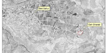
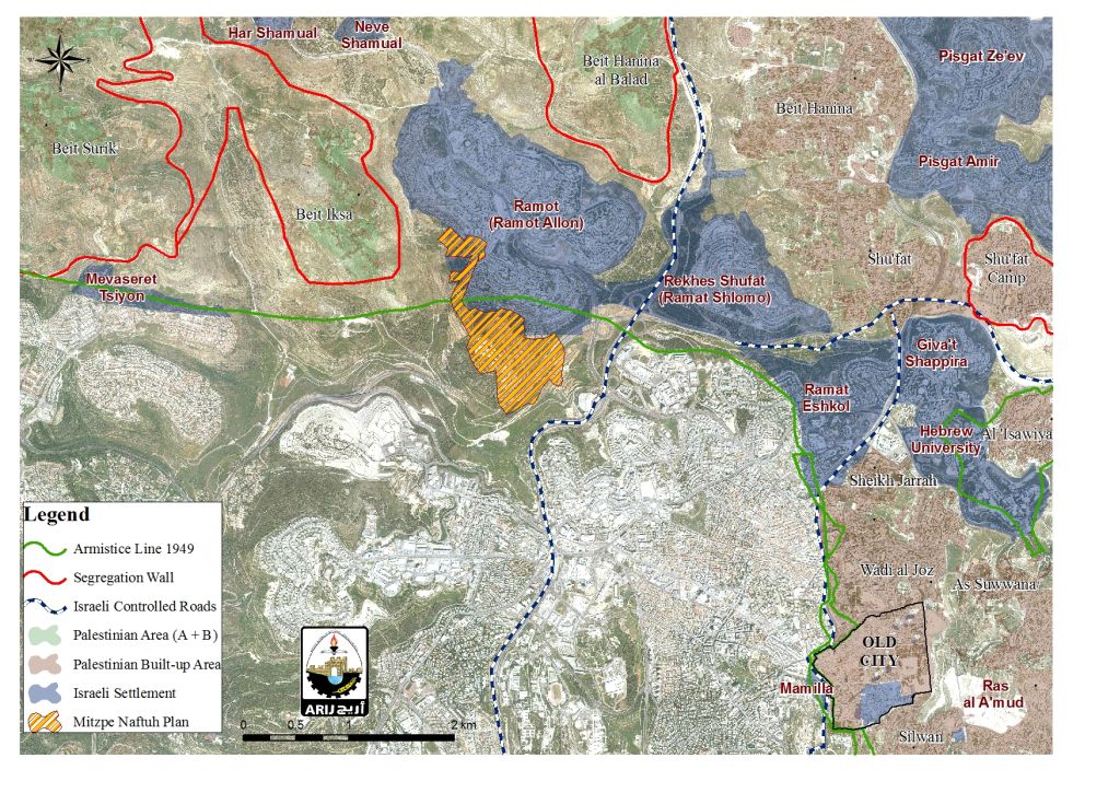
Moreover, the village of Beit Iksa has been severely affected by the construction of the Israeli Segregation Wall on its lands. Since Israel started the construction of the wall onBeit Iksa lands, the route of the wall has been subjected to many changes. These changes were made to avoid geographic obstacles in the village that hindered the construction of the Wall, however, had their negative impacts upon the village and its citizens. Maps issued by the so called "Israeli Defense Ministry" on the 30th of June 2004 and 20th of February 2005 showed that the Wall would isolate Beit Iksa from its neighboring villages to the north-west of Jerusalem City, and illustrated the area to be annexed to Israel. On the the 30th June 2006, the "Israeli Ministry of Defense" published an amendment to the Wall route in Beit Iksa which excluded the village from the isolated area, proposing that it would be surrounded by the Wall on its eastern, southern, and western sides, whilst the northern side would be open for village residents to travel to and from the village at any time. Although the built-up area in the village is set outside the Wall under the new amendment; however, the amendment will seize a large area of agricultural lands and open space in the village. Note that the amendment hasn't been put into effect and Beit Iksa village is still entrapped inside the wall. See Map 2

The Israeli Segregation Wall plan on lands of Beit Iksa village northwest of Jerusalem


[1]  תכנית מתאר למצפה נפתוח – 1395 יחידות דיור

תוכנית 6885
http://www.tabainfo.co.il/entity/%D7%AA%D7%9B%D7%A0%D7%99%D7%AA
%20%D7%9E%D7%AA%D7%90%D7%A8%20%D7%9C%D7%9E%D7%A6%D7%A4%D7%94
%20%D7%A0%D7%A4%D7%AA%D7%95%D7%97%20-%201395%20%D7%99%D7%97%D
7%99%D7%93%D7%95%D7%AA%20%D7%93%D7%99%D7%95%D7%A8-1032964

[2] The Har Homa Settlement and the Uprooting of Abu Ghnaim Forest

http://www.old.poica.org/details.php?Article=8419


Prepared by:  
The Applied Research Institute – Jerusalem


Recommended For You

“الاستيطان الإسرائيلي يستحوذ على ما تبقى من المساحات الخضراء في محافظة بيت لحم

by arij
August 19, 2024
0
“الاستيطان الإسرائيلي يستحوذ على ما تبقى من المساحات الخضراء في محافظة بيت لحم

أعلن ما يسمى بوزير المالية والوزير في وزارة الاحتلال الإسرائيلي بتسلئيل سموتريتش يوم الرابع عشر من شهر اب من العام 2024 عن قراره بإقامة مستوطنة إسرائيلية جديدة على...

Read moreDetails

إسرائيل تعطي الضوء الأخضر لبناء مستوطنة جديدة في قلب مدينة الخليل

by arij
April 24, 2024
0
إسرائيل تعطي الضوء الأخضر لبناء مستوطنة جديدة في قلب مدينة الخليل

  أعلنت الإدارة المدنية الإسرائيلية، الذراع الأيمن لحكومة الاحتلال الاسرائيلي في الضفة الغربية المحتلة, في الاسبوع الاول من شهر نيسان من العام 2024, عن مخططا استيطانيا جديدا يستهدف...

Read moreDetails

مستوطنة جديدة تبصر النور على أراضي بلدة دير استيا

by arij
August 15, 2022
0
مستوطنة جديدة تبصر النور على أراضي بلدة دير استيا

   صادقت سلطات الاحتلال الإسرائيلي يوم التاسع من شهر اب من العام 2022 على المخطط الاستيطاني الإسرائيلي رقم 5/170 والذي يقضي بإقامة مستوطنة جديدة على أراضي فلسطينية تتبع...

Read moreDetails

New Outpost Built in Al-Lubban Ash-Sharqiya / Nablus Governorate

by arij
August 6, 2022
0
New Outpost Built in Al-Lubban Ash-Sharqiya / Nablus Governorate

  Violation: Establishing a new outpost. Location: Al-Lubban Ash-sharqiya village. Date: June 19th 2022. Perpetrator: Colonists of “Ma’ale Levona”. Victims: Farmer ‘Atta Juma’a. Description: A group of illegal...

Read moreDetails

 إقامة بؤرة استعمارية على أراضي قرية اللبن الشرقية / محافظة نابلس

by arij
July 7, 2022
0
 إقامة بؤرة استعمارية على أراضي قرية اللبن الشرقية / محافظة نابلس

  الانتهاك: اقامة بؤرة استعمارية. الموقع: قرية اللبن الشرقية / جنوب مدينة نابلس. تاريخ الانتهاك: 19/06/2022م. الجهة المعتدية: مستعمرة "معاليه ليفونة ". الجهة المتضررة: المزارع عطا محمود جمعة....

Read moreDetails
Next Post
تقرير الانتهاكات الإسرائيلية في الأراضي المحتلة – تشرين الثاني 2015

تقرير الانتهاكات الإسرائيلية في الأراضي المحتلة – تشرين الثاني 2015

LATEST NEWS

الأراضي الفلسطينية بين الذرائع الأمنية والأطماع الاستيطانية – “الأمن، الآثار، والطبيعة كحجج لاقتلاع الفلسطينيين من أراضيهم”

by arij
April 15, 2025
0

........................................................

الطرق الالتفافية الاسرائيلية وأثرها على البيئة الفلسطينية

انتهاك للطبيعة والهوية في الأراضي الفلسطينية المحتلة

by arij
March 17, 2025
0

........................................................

Israel Advances Settlement Plan on Ancient Olive Groves on lands of Beit Jala city, Violating International Law and depriving Palestinians their lands

إسرائيل تمضي قدمًا في مخطط استيطاني جديد على أراضي مدينة بيت جالا، في انتهاك للقانون الدولي وحرمان الفلسطينيين من أراضيهم

by arij
April 29, 2025
0

........................................................

Israel Advances Settlement Plan on Ancient Olive Groves on lands of Beit Jala city, Violating International Law and depriving Palestinians their lands

Israel Advances Settlement Plan on Ancient Olive Groves on lands of Beit Jala city, Violating International Law and depriving Palestinians their lands

by arij
April 29, 2025
0

........................................................

flag_yellow_lowEU-PfP-Logo

This website has been produced with the assistance of the European Union. The contents of this publication are the sole responsibility of ARIJ & LRC and can in no way be taken to reflect the views of the European Union.

© 2025 Copyright ARIJ . All Rights reserved. .

No Result
View All Result
  • Home
  • Settlements
    • New Israeli Settlements
    • Settlement Expansion
  • Israeli Violations
    • Agriculture
    • Confiscation
    • Demolition
    • Environment
    • Eviction of Palestinians
    • Settlers Attacks
  • Bypass Roads
  • Israeli Plans
  • Segregation
    • Checkpoints
    • Closure
    • Separation Plans
  • Military Orders
  • Reports
    • Daily Report
    • Monthly Report
    • Quarterly Report

© 2025 Copyright ARIJ . All Rights reserved. .