• About The Project
  • Palestine in Century
  • Selected Maps
  • Glossary
  • About ARIJ
  • About LRC
  • By Year
    • Case Studies By Year
    • Daily Report By Year
Thursday, October 2, 2025
POICA
No Result
View All Result
  • Home
  • Settlements
    • New Israeli Settlements
    • Settlement Expansion
  • Israeli Violations
    • Agriculture
    • Confiscation
    • Demolition
    • Environment
    • Eviction of Palestinians
    • Settlers Attacks
  • Bypass Roads
  • Israeli Plans
  • Segregation
    • Checkpoints
    • Closure
    • Separation Plans
  • Military Orders
  • Reports
    • Daily Report
    • Monthly Report
    • Quarterly Report
No Result
View All Result
POICA
No Result
View All Result

Israeli orders targeted Palestinian land in Sa’ir Town Northeast of Hebron Governorate

March 16, 2015
in Military Orders
Israeli orders targeted Palestinian land in Sa’ir Town Northeast of  Hebron Governorate

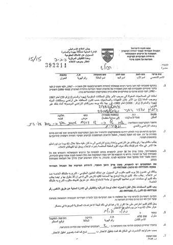
On the 12th of March 2015, what is so-called the “Israeli Civil Administration” related to the Israeli Occupation Army issued 5 military orders to evacuate Palestinian lands in Khirbet Jurat Al-Khail area in Sai’r town, northeast of the city of Hebron.

No. of Military Orders

Area (Dunums)

Trees/Structures

392213

6

250 trees

392214

12

300 trees

392215

6.5

70 trees

392216

5

50 trees

392217

2

15 trees

Total

31.5 dunums

685 trees


The expropriation orders ,issued by the “Custodian of the State Property” , claimed that the targeted lands classified as “State land” and therefore, the Palestinian land owners have to evacuate it within 45 days, including  the uprooting of all the trees and demolition all the structures in the lands. Noted that the lands are agricultural lands, and planted with about 685 trees.

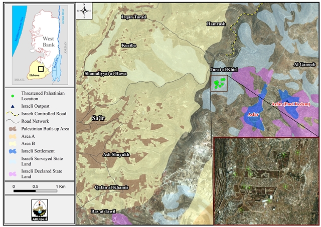
The Location of the targeted land

A geopolitical analysis conducted by the Settlement Monitoring Department at the Applied Research Institute – Jerusalem (ARIJ), showed that the targeted lands located in Khirbet Jurat Al-Khail, northeast of Sai’r town in Hebron governorate…Moreover, the targeted lands located within an area classified by the Israeli Authorities as“ Survey State land”, which means that the Israeli Authorities prepared to declare these land (31.5 dunums) as “State land”. Also, the targeted lands located within the area classified as “Area C” (According to Oslo Accords in 1995), which means that the Area C , Israeli Authorities retains full control over security and administration matters.

These orders will help the Israeli Authorities to confiscate the land (31.5 dunums) under the claim of “State land”, and the targeted lands surrounded by lands and areas “Survey State land” and “Declared state land”, and the Israeli illegal settlement of Asfar located southeast of the targeted land. For that, the confiscation of these lands will serve the Israeli settlement project and the expansion of the aforementioned settlement in specific.

“State Land” Expropriation

  • Before 1967, the Jordanian government was responsible for the lands in the West Bank, and some of these lands were under the Jordanian Authorities control and classified as “State land”.
  • Following the Israeli military occupation of the Palestinian Territory in 1967,  Israel took over all of the lands; included the those  classified during the Jordanian rule as “State land”.
  • Later on , and throughout the years of the Israeli occupation, the Israeli authorities had surveyed the lands in the West bank, and declared some of it as “State land” and keep others as “Survey state land” as an initial step it to be declared as “State land” late on…

For that, the military orders which targeted 31.5 dunums of private Palestinian land in Sai’r town, considered a first step to annex the land by declaring its as “State land”, to be officially under the Israeli Authorities control.

Sa’ir is a Palestinian town located about 8 kilometers northeast of the city of Hebron in the southern parts of the West Bank. It is bordered by the Dead Sea from the east, Beit Fajjar and Al Arroub camp from the north, Halhul town to the west and Bani Na’im and Al Shuyukh villages to the south.

Sa’ir is surrounded by two illegal Israeli settlements Asfer and Kiryat Arba’. The illegal settlement of Asfer built on 1500 dunums east of Sa’ir while the settlement of Kiryat Arba’ built on 300 dunums from the Palestinian lands to the west of the town.

Furthermore, one gate, several flying checkpoints and earth mound roadblocks restrict town residents.

Prepared by:  
The Applied Research Institute – Jerusalem


Recommended For You

سلطات الاحتلال الإسرائيلي تستغل ‘المنفعة العامة’ لنهب الموارد الفلسطينية

by arij
September 30, 2025
0
سلطات الاحتلال الإسرائيلي تستغل ‘المنفعة العامة’ لنهب الموارد الفلسطينية

في الاول من شهر ايلول من العام 2025، نشرت الإدارة المدنية الإسرائيلية، الذراع الأيمن لحكومة الاحتلال الإسرائيلي أمرا عسكريا جديدا تحت عنوان " أمر ءبشأن قانون الأراضي (الاستملاك...

Read moreDetails

The Occupation Targets the Village of Raba Southeast of Jenin with Military Orders and Seizes Vast Areas of Its Lands

by arij
September 13, 2025
0
الاحتلال يستهدف بأوامر عسكرية قرية رابا جنوب شرق جنين ويصادر مساحات واسعة من أراضيها

 The Israeli occupation Army have continued their policy of plundering Palestinian lands, as their bulldozers leveled wide areas of agricultural land in the village of Raba, southeast of...

Read moreDetails

الاحتلال يستهدف بأوامر عسكرية قرية رابا جنوب شرق جنين ويصادر مساحات واسعة من أراضيها

by arij
September 13, 2025
0
الاحتلال يستهدف بأوامر عسكرية قرية رابا جنوب شرق جنين ويصادر مساحات واسعة من أراضيها

  واصلت قوات الاحتلال الإسرائيلي سياسة نهب الأراضي الفلسطينية، حيث أقدمت آلياتها على تجريف أراض زراعية واسعة في قرية رابا جنوب شرق محافظة جنين، تمهيدا لشق شارع عسكري...

Read moreDetails

Nablus Governorate’s Archaeological Sites Face Israeli Expropriation Plans

by arij
September 11, 2025
0
” المواقع الأثرية في محافظة نابلس… ساحة مفتوحة أمام مخططات المصادرة الإسرائيلية “

On 10 August, 2025, the Israeli Civil Administration (ICA), issued a booklet of military orders signed by the head of the so-called ‘Israeli Civil Administration’ in the occupied...

Read moreDetails

” المواقع الأثرية في محافظة نابلس… ساحة مفتوحة أمام مخططات المصادرة الإسرائيلية “

by arij
August 26, 2025
0
” المواقع الأثرية في محافظة نابلس… ساحة مفتوحة أمام مخططات المصادرة الإسرائيلية “

في العاشر من شهر اب من العام 2025, أصدرت الإدارة المدنية الإسرائيلية كراسة أوامر عسكرية موقعة من قبل رئيس ما يسمى "بالإدارة المدنية الإسرائيلية" في الضفة الغربية المحتلة,...

Read moreDetails
Next Post

ARIJ Daily Report - Mon, 16th 03 2015

LATEST NEWS

Annexation of the Jordan Valley: Implications for the Two-State Solution and Regional Stability

Annexation of the Jordan Valley: Implications for the Two-State Solution and Regional Stability

by arij
September 29, 2025
0

........................................................

Isolation of Three Villages Northwest of Jerusalem: Silent Annexation Creeps toward the Capital

عزل ثلاث قرى فلسطينية شمال غرب مدينة القدس: الضم الاسرائيلي الصامت يزحف نحو محيط العاصمة

by arij
September 24, 2025
0

........................................................

Isolation of Three Villages Northwest of Jerusalem: Silent Annexation Creeps toward the Capital

Isolation of Three Villages Northwest of Jerusalem: Silent Annexation Creeps toward the Capital

by arij
September 24, 2025
0

........................................................

سياسات التهويد في القدس: من السيطرة المكانية إلى طمس الهوية عبر التسمية

سياسات التهويد في القدس: من السيطرة المكانية إلى طمس الهوية عبر التسمية

by arij
September 23, 2025
0

........................................................

flag_yellow_lowEU-PfP-Logo

This website and its content were initiated in 1993 by the Applied Research Institute – Jerusalem (ARIJ) and the Land Research Center (LRC) with the support from the European Union up until 2023. Since then, the Applied Research Institute – Jerusalem (ARIJ) has taken over the continued development and maintenance of the website. The views expressed remain solely those of ARIJ) and do not necessarily reflect those of the European Union.

© 2025 Copyright ARIJ . All Rights reserved. .

No Result
View All Result
  • Home
  • Settlements
    • New Israeli Settlements
    • Settlement Expansion
  • Israeli Violations
    • Agriculture
    • Confiscation
    • Demolition
    • Environment
    • Eviction of Palestinians
    • Settlers Attacks
  • Bypass Roads
  • Israeli Plans
  • Segregation
    • Checkpoints
    • Closure
    • Separation Plans
  • Military Orders
  • Reports
    • Daily Report
    • Monthly Report
    • Quarterly Report

© 2025 Copyright ARIJ . All Rights reserved. .