• About The Project
  • Palestine in Century
  • Selected Maps
  • Glossary
  • About ARIJ
  • About LRC
  • By Year
    • Case Studies By Year
    • Daily Report By Year
Friday, May 9, 2025
POICA
No Result
View All Result
  • Home
  • Settlements
    • New Israeli Settlements
    • Settlement Expansion
  • Israeli Violations
    • Agriculture
    • Confiscation
    • Demolition
    • Environment
    • Eviction of Palestinians
    • Settlers Attacks
  • Bypass Roads
  • Israeli Plans
  • Segregation
    • Checkpoints
    • Closure
    • Separation Plans
  • Military Orders
  • Reports
    • Daily Report
    • Monthly Report
    • Quarterly Report
No Result
View All Result
POICA
No Result
View All Result

Preparations for Establishing a New Colony west of Salfit city

May 26, 2014
in Settlement Expansion
Preparations for Establishing a New Colony west of Salfit city


Violation: Embarking on building a new colony
Location: Dhahr Soboh, Kafr ad Dik- Salfit governorate
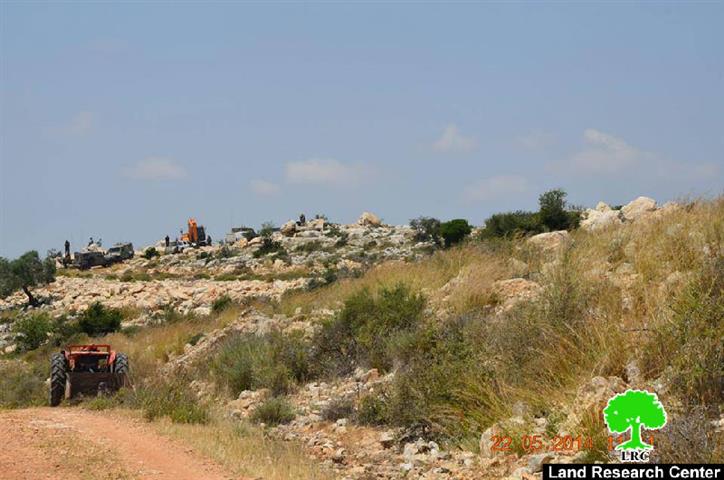
Date: 22 and 25 of May, 2014
Perpetrators: The Israeli occupation army
Victims: People of the villages and towns of Badia, Sarta, Bruqin and Kafr ad Dik

Details:

On May 22, 2014, the Israeli occupation army accompanying a group of colonists broke into Dhahr Soboh, north of Kafr ad Dik, west of the West Bank city of Salfit where they surveyed the area.

On May 25, colonists driving five bulldozers ravaged agricultural lands under the protection of the Israeli army. More than 80 dunums planted with 150 trees were totally razed for the sake of the new outpost that is going to be built on the lands of Kafr ad Dik and Badia. The targeted lands are surrounded with Bruchin and Ali Zahav colonies.

It should be marked that the process of ravaging and destroying agricultural lands is ongoing until the time of writing the report which might lead to a true crisis in the area.


Pictures of the ravaging operation in Dhahr Soboh/  Kafr ad Dik town

Dhahr Soboh is at the heart of the governorate of Salfit. It is on a mountain peak overlooking Kafr ad Dik, Badia, Deir Ballot, Rafat, Qarawat, and Sarta among others. It is also rife with olive trees which many families consider their source of income.

The area has always been targeted by the Israeli occupation, mainly because of its strategic geographic location. The area is strangled by Ali Zahav and Bedoel (from the west), Ariel, Barkan Industrial Zone and Bruchin (from the east).

The Israeli occupation is currently trying to devour as much agricultural land of Dhahr Soboh as possible for the construction of a new outpost in the area under the pretext that Dhahr Soboh is "state property" though Palestinians have all the deeds that prove their ownership.

It is worth mentioning that the Israeli occupation forces prepared for all that in advance. In 2011, it led a large-scale demolition operation in the area, leveling 13 agricultural cisterns among other structures in a bid to force Palestinians out. LRC prepared a study case about the assault back then. (Kindly check http://www.old.poica.org/details.php?Article=3366)

And in 2012, the Israeli occupation government approved the plans of the construction of a new outpost in Dhahr Soboh, without informing inhabitants and landowners. The Israeli occupation claimed it issued a military order about it while Palestinians in Salfit negate receiving any.

The Importance of Dhohr Soboh to Salfit:

Dhahr Soboh is 300 dunums of agricultural land planted with olive trees. It lies in the heart of Salfit and its land is considered futile. It has a number of water springs and hosts a number of Roman and Islamic monuments.

Dhahr Soboh provides a source of living to many families who consider farming their only profession. This is considered vital especially that Salfit governorate suffers from a high poverty rate and active colonial activity. 

Kafr ad Dik [i]

Kafr ad Dik is located 15 km to the west of Salfit. It is surrounded by Bidya (north), Rafat and Deir Ballut (west), Bruqin and Sarta (east), and Bani Zaid villages (south).

Kafr ad Dik has a population of 4553 people, according to a 2007 census.  

Its total area is 15529 dunums; however, it has been suffocated by bypasses and 3 Israeli colonies that lay over its lands.

This has further limited its expansion knowing that it had already had a 791-dunum organizational plan (built-up area); it also isolated the village from its surroundings.

The Israeli occupation confiscated 2477 dunums of Kafr ad Dik lands for the benefit of:

  1. Colonies devoured 1225 dunums, and they are:

Name of colony

Year of construction

Area of confiscated land/ dunum

Number of colonists

Har Eli Zahav

  1.  
  1.  
  1.  

Eli Zahav- Yoezer

  1.  
  1.  
  1.  

Bedoel

  1.  
  1.  
  1.  
  •  
  1.  
  1.  
  1.  
  •  
  1.  
  1.  

*Source: Field Research- Monitoring Israeli Violations Team- Land Research Centre (LRC).

  1. Bypasses stole 362 dunums
  2. The Apartheid Wall seized 890 dunums and isolated 8824 dunums and is expected to be 8905 long in Kafr ad Dik lands.

Lands of Kafr ad-Dik are categorized according to Oslo Accords into lands under Area B (15% of the lands) and lands under Area C (85% of the lands).

i] Source: Geographic Information System- Monitoring Israeli Violations Team- Land Research Center


Prepared by:  
The Land Research Center

LRC 

Recommended For You

إسرائيل تمضي قدمًا في مخطط استيطاني جديد على أراضي مدينة بيت جالا، في انتهاك للقانون الدولي وحرمان الفلسطينيين من أراضيهم

by arij
April 29, 2025
0
Israel Advances Settlement Plan on Ancient Olive Groves on lands of Beit Jala city, Violating International Law and depriving Palestinians their lands

  في أواخر شهر شباط من العام 2025، صادقت دولة الاحتلال الإسرائيلي على مخطط استيطاني جديدة لبناء حي سكني للمستوطنين على مساحة 22.2 دونما من الأراضي الفلسطينية لتابعة...

Read moreDetails

سلطات الاحتلال الإسرائيلي تصادر 64 دونما شمال مدينة بيت لحم لإقامة موقفا للحافلات

by arij
October 19, 2023
0
سلطات الاحتلال الإسرائيلي تصادر 64 دونما شمال مدينة بيت لحم لإقامة موقفا للحافلات

  في السابع من شهر أيلول من العام 2023, صادقت بلدية الاحتلال الإسرائيلي في القدس المحتلة على مخطط استيطاني جديد من شأنه أن يصادر مساحات شاسعة من أراضي...

Read moreDetails

Israeli Settlements in the Occupied West Bank: from “outposts” to urban blocks

by arij
May 20, 2023
0
Israeli Settlements in the Occupied West Bank: from “outposts” to urban blocks

  The Applied Research Institute – Jerusalem (ARIJ) In cooperation with Palestine Economic Policy Research Institute (MAS)   Preface Legalizing nine Israeli settlement outposts in the occupied West...

Read moreDetails

استكمال انشاء حي استعماري تابع لمستعمرة ” الكانا” على أراضي قرية مسحة / محافظة سلفيت

by arij
November 1, 2022
0
استكمال انشاء حي استعماري تابع لمستعمرة ” الكانا” على أراضي قرية مسحة / محافظة سلفيت

  الانتهاك: توسع استيطاني. الموقع: قرية مسحة / محافظة سلفيت. تاريخ الانتهاك: تشرين أول 2022. الجهة المعتدية: مستعمرة " الكانا". الجهة المتضررة: أهالي قرية مسحة.  تفاضيل الانتهاك:   استكمل...

Read moreDetails

بواقع “4,762 دونما”, سلطات الاحتلال تصادق على عددا من المخططات الاستيطانية منذ بداية شهر تشرين أول 2022

by arij
October 19, 2023
0
بواقع “4,762 دونما”, سلطات الاحتلال تصادق على عددا من المخططات الاستيطانية منذ بداية شهر تشرين أول 2022

  كشفت سلطات الاحتلال الإسرائيلي منذ بداية شهر تشرين الأول من العام 2022, عن مصادقتها لعددا من المخططات الاستيطانية في عددا من المستوطنات الإسرائيلية في الضفة الغربية المحتلة....

Read moreDetails
Next Post

ARIJ Daily Report - Tue, 27th 05 2014

LATEST NEWS

الأراضي الفلسطينية بين الذرائع الأمنية والأطماع الاستيطانية – “الأمن، الآثار، والطبيعة كحجج لاقتلاع الفلسطينيين من أراضيهم”

by arij
April 15, 2025
0

........................................................

الطرق الالتفافية الاسرائيلية وأثرها على البيئة الفلسطينية

انتهاك للطبيعة والهوية في الأراضي الفلسطينية المحتلة

by arij
March 17, 2025
0

........................................................

Israel Advances Settlement Plan on Ancient Olive Groves on lands of Beit Jala city, Violating International Law and depriving Palestinians their lands

إسرائيل تمضي قدمًا في مخطط استيطاني جديد على أراضي مدينة بيت جالا، في انتهاك للقانون الدولي وحرمان الفلسطينيين من أراضيهم

by arij
April 29, 2025
0

........................................................

Israel Advances Settlement Plan on Ancient Olive Groves on lands of Beit Jala city, Violating International Law and depriving Palestinians their lands

Israel Advances Settlement Plan on Ancient Olive Groves on lands of Beit Jala city, Violating International Law and depriving Palestinians their lands

by arij
April 29, 2025
0

........................................................

flag_yellow_lowEU-PfP-Logo

This website has been produced with the assistance of the European Union. The contents of this publication are the sole responsibility of ARIJ & LRC and can in no way be taken to reflect the views of the European Union.

© 2025 Copyright ARIJ . All Rights reserved. .

No Result
View All Result
  • Home
  • Settlements
    • New Israeli Settlements
    • Settlement Expansion
  • Israeli Violations
    • Agriculture
    • Confiscation
    • Demolition
    • Environment
    • Eviction of Palestinians
    • Settlers Attacks
  • Bypass Roads
  • Israeli Plans
  • Segregation
    • Checkpoints
    • Closure
    • Separation Plans
  • Military Orders
  • Reports
    • Daily Report
    • Monthly Report
    • Quarterly Report

© 2025 Copyright ARIJ . All Rights reserved. .