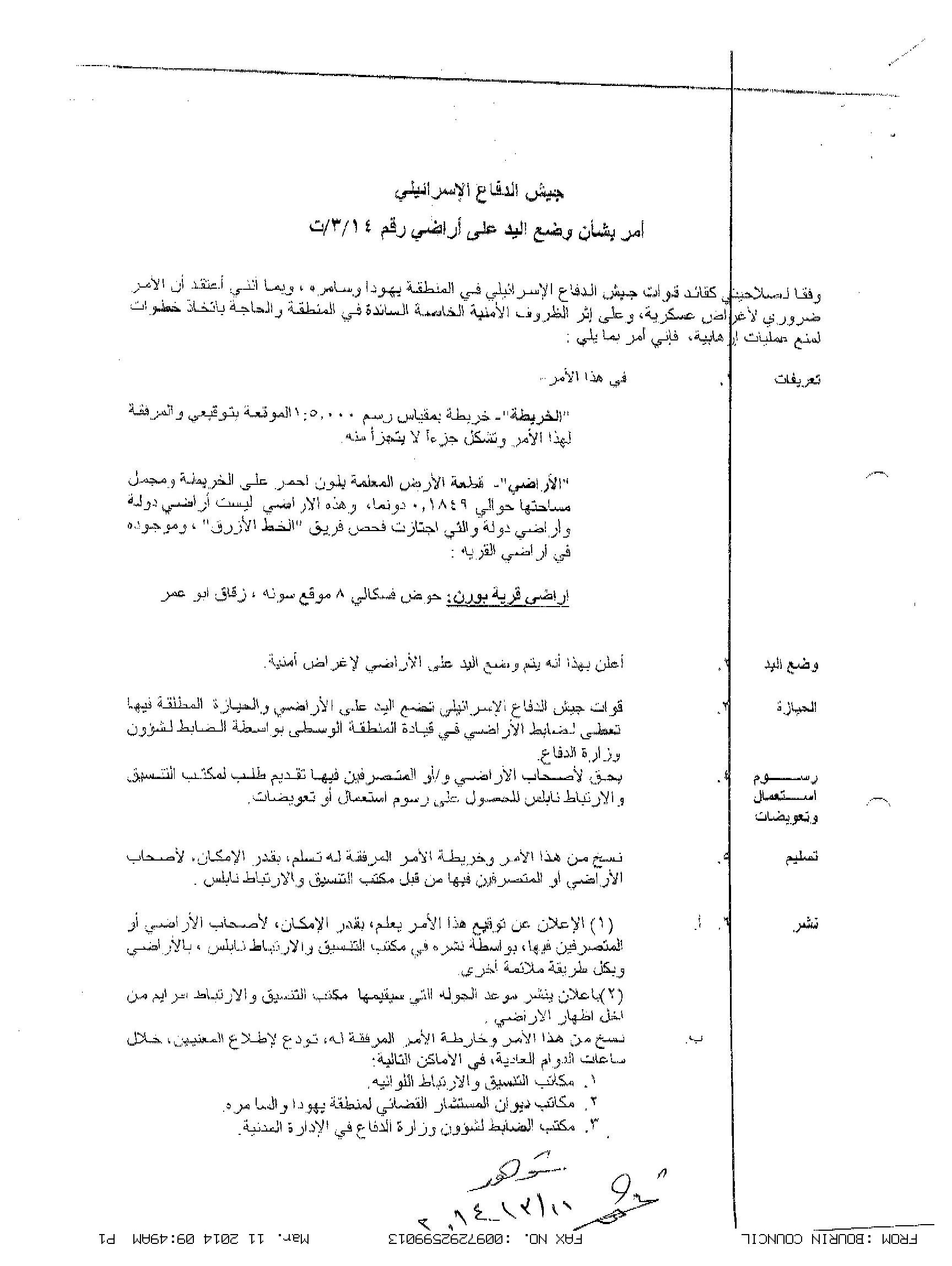
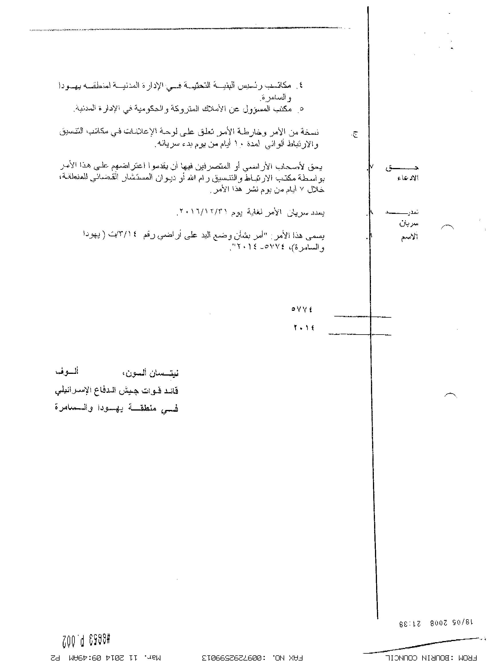
On the 23rd of February 2014, the Israeli Occupation Authorities (IOA) issued a military order No. T/03/14, to confiscate 184 square meters (0.1849 dunums) of Palestinian land in Burin village in Nablus governorate. The military order marked block No. 8 in Sauna and Zuqaq Abu Omar areas in the village as the targeted land for the implementation of the colonial plans.
According to the military order, the confiscation of the land comes for “Security needs”, with no further explanation of the type of security needs. Additionally, the military order sets the 31st of December 2016 as the final date for the Israeli army to implement its plan in the area, otherwise, the IOA will extend the validity of the military order until plans are completely implemented.
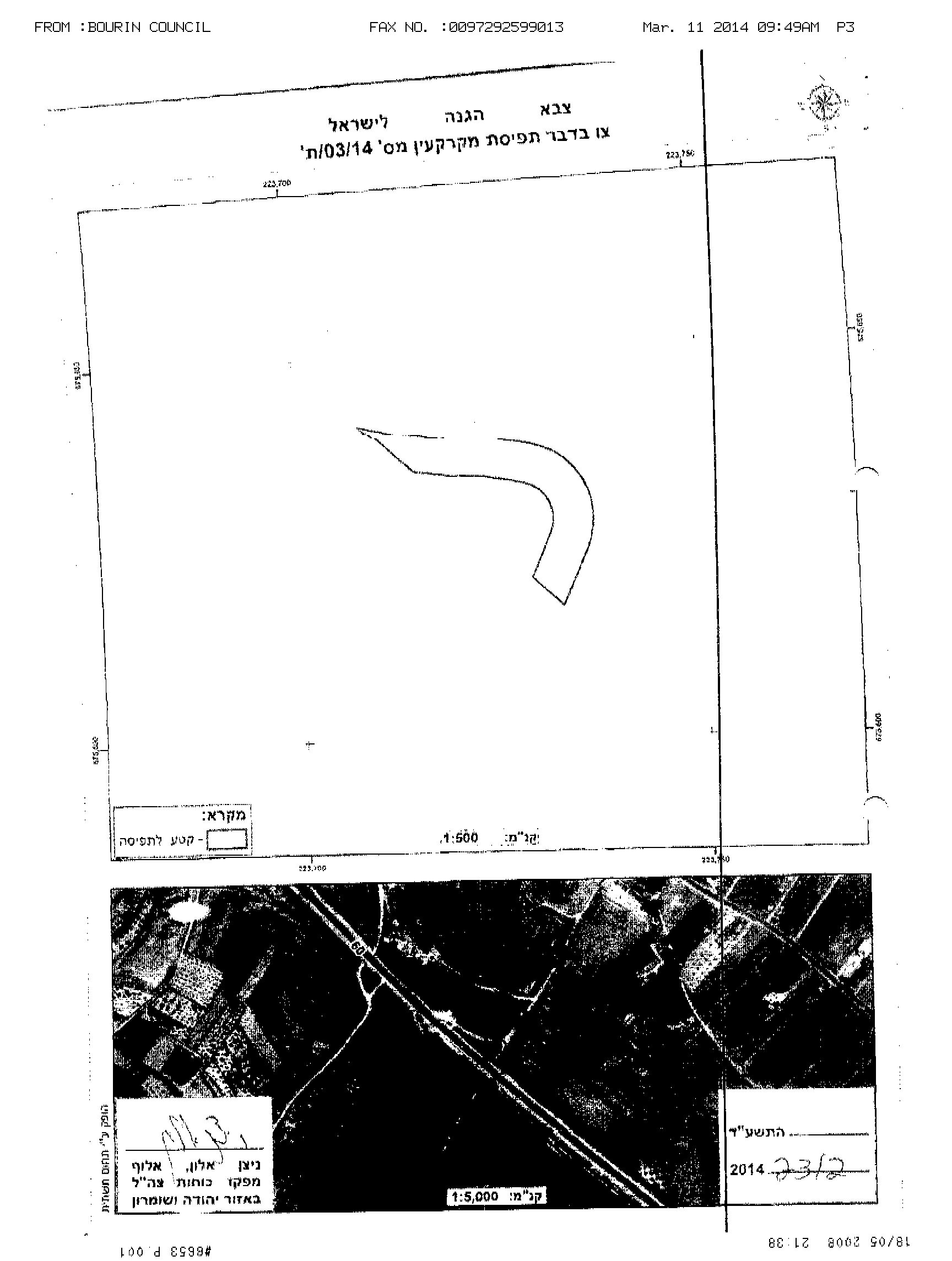
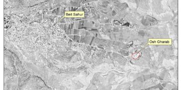
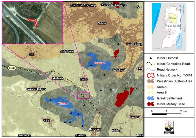
Analysis conducted by the Applied Research Institute – Jerusalem (ARIJ) of the military order, the attached maps and satellite photos showed that the targeted land is parallel in location to the Israeli Bypass road No.60, and is opposite to Burin High School for Boys. Furthermore, the Israeli settlement of Yetzhar is located to the south of the targeted land.
The control over this piece of land comes probably to establish an Israeli Military point (military watchtower) in the targeted land, which in turn, will turn the area into a strategic point for the Israeli Army to monitor the Israeli settlers vehicles' movement on the Israeli Bypass road No.60 which links between the Israeli settlements in the southeastern part of Nablus city and those settlements located in the western part of the city (Nablus).
The Israeli settlers who use the Israeli bypass road No.60 claim that their vehicles are constantly exposed to stone hurling from Palestinians, and according to the Israeli Occupation Authorities, a military tower in that area will prevent such attacks.
The establishment of a permanent Israeli military tower in this particular location will put the nearby Palestinian agricultural lands under threat, as Palestinian farmers might lose access to their lands in the future if Israel decides to extend its control over the land again for “security needs”. Additionally, the targeted location is not that far from Burin School for Boys, which will trigger clashes between Palestinian students and the Israeli Army in the area.
The attached maps also showed that the targeted land is located in an area classified by Israel as “C” area, which falls under the full control of the Israeli Authorities related to security and civil matters. This in turn, gives the Israeli Army the excuse to continue storming Burin village and the surrounding Palestinian villages, under the claim of “security checks”.
Note that Palestinians of Burin Village received the military order No. T/03/14 on the 10th of March 2014, 16 days after it was issued (on February 23); which prevents them from filing objections against the issued military order since the period set for objection is seven days from the issuance date of the order and thus residents of Burin village lost their right to object the orders as the period set for objection ended. See Map 1

Map 1: The targeted land in the Military Order No. T/03/14
Burin village, population and geography:
Burin, is a Palestinian village located to the south of Nablus city. It is bordered by Kafr Qallil village to the east, the Israeli settlement of Bracha to the north, Madama and Asira Al-Qibliya villages to the west, and the Israeli settlement of Yitzhar to the south. The total area of Burin village is 18487 dunums and is inhabited by 2563 Palestinians (PCBS ,2012 [1]).
Geopolitical situation in Burin village:
According to Oslo II Interim Agreement signed in September 1995, between the Palestinian National Authority and the Israeli government, concluded Israel’s withdrawal from areas of the West Bank, and that the occupied territory be classified into Areas “A”, “B” and “C”. In Burin village, 525 dunums of Burin village land was classified as area “A” where Palestinians hold all administrative responsibilities including internal security and Public order; while 6150 dunums of Burin land is classified as area “B” where Palestinians have full control over the civil matters and Israel continues to have full control over the security matters; whereas the remaining area of Burin village, which sets at 11812 dunums, was classified as area “C”, which falls under the full control of the Israeli Authorities, security and Administrative matters while Palestinians have responsibility for civil life such as economics, health, and education; . (See Table 1)
|
Table No.1: The geopolitical classification of Burin village land according to Oslo II Interim Agreement of 1995. |
||
|
Land classification |
Area (dunums) |
% of the total area |
|
Area A |
525 |
2.8 |
|
Area B |
6150 |
33.3 |
|
Area C |
11812 |
63.3 |
|
Total |
18487 |
100 |
|
Source: the Applied Research Institute- Jerusalem (ARIJ)- 2013 |
||
The illegal Israeli settlements and outposts on Palestinian lands in Burin village:
After the Israeli army occupied the Gaza strip and the West Bank including east Jerusalem in 1967, Israel started the construction of Israeli settlements on the territory it occupied in a step aiming at imposing its control over the Palestinian territory, and to impose facts on the ground in a way that can’t be changed in the future. Today, and according to the analysis of the high precision aerial photos at the Applied Research Institute- Jerusalem (ARIJ), there are 196 illegal Israeli settlements in the occupied West Bank housing around 700 thousand settlers, in addition to more than 232 illegal outposts. In Burin village only, the Israeli Authorities constructed two illegal settlements along with five illegal outposts:
— The settlement of Bracha:
Bracha settlement is located to the north of Burin village and occupies a total of 985 dunums of land; of which, 581 dunums are of Burin village land. Bracha settlement was established in the year 1982.
In the year 1991, the Israeli Civil Administration issued master plans for Israeli settlements in the occupied Palestinian territory (oPt) including those established in the eastern part of Jerusalem city. The master plans allocated additional land for the establishment of new settlements in the future and the expansion of the existing ones that were established until the year of 1991. Although the master plan of Bracha settlement showed that the future expansion area of the settlement will reach to 411 dunums, the current area of the settlement nowadays is twice the size of the settlement master plan. Today, the settlement is home to 1770 Israeli settlers (ARIJ, 2011).
— The settlement of Yizhar
Yizhar settlement is located south of Burin village and occupies 522 dunums of Burin land. The illegal settlement of Yitzhar was established in the year 1983 and its total area is 1354 dunums. The master plan issued by the Israeli civil administration in 1991 showed that the future expansion area of the settlement is 1539 dunums of land. Today, the settlement is inhabited by 1100 Israeli settlers (ARIJ, 2011).
— Five illegal Israeli outposts established on Burin village land:
Additionally, Israeli settlers, and with the indirect help of the Israeli occupation Authorities established five illegal outposts on Burin village land, they are, Ein Haroun “south Bracha”, Sineh Yakov, Bracha A, Hill 778, and Shilhvet “east Yizhar”.
To conclude
In short, Israel has no reluctance to target any piece of land, no matter how small its size is, with military orders, to impose its control over as much Palestinian land as possible for the benefit of Israeli settlements. Additionally, when it comes to the security of settlements and Settlers, Israel is willing to sacrifice all its efforts in that manner and these actions become legal and non-arguable.
For so long, Israel has considered the “security needs” term as a prelude to confiscate Palestinian lands, expand Israeli settlements and outposts, construct Bypass roads, establish Israeli watch towers and military bases and finally to construct the Israeli segregation wall which already confiscates vast areas of Palestinian land in the West Bank. These practices are of grave breach to the International laws, Human Conventions, UN Resolutions, and the Peace agreements that were signed with the Palestinians, some of which, are listed below:
— United Nations Security Council Resolution 446 (1979): “the policy and practices of Israel in establishing settlements in the Palestinian and other Arab territories occupied since 1967 have no legal validity and constitute a serious obstruction to achieving a comprehensive, just and lasting peace in the Middle East"
— United Nations Security Council Resolution 242 (1967) which requires Israeli armed forces to withdraw from 'the territories occupied' in the 1967 war, including the West Bank and Gaza Strip.
— United Nations Security Council Resolution 452 (1979) which calls upon 'the Government and people of Israel to cease, on an urgent basis, the establishment, construction and planning of settlements in the Arab territories occupied since 1967, including Jerusalem.'
— United Nations Security Council Resolution 465 (1980) which 'Determines that all measures taken by Israel to change the physical character, demographic composition, institutional structure of status of the Palestinian and other Arab territories occupied since 1967, including Jerusalem, or any part thereof, have no legal validity and that Israel's policy and practices of setting parts of its population and new Immigrants in those territories constitute a flagrant violation of the fourth Geneva convention relative to the protection of civilian persons in time of war and also constitute a serious obstruction to achieving a comprehensive, just and lasting peace in the Middle East.'
May 2001,– Michel's Report – stated that the most important step to be followed by Israel to facilitate access to a comprehensive peace between the two parties is to freeze all settlement activity in the occupied territories and stop the natural expansion of existing settlements originally.
— Oslo agreement of 1995, Article 31, stipulates that “prevents the lateral Israeli and Palestinians building or planning any settlements or settlement expansion or any other project that would alter the status quo in the West Bank and the Gaza strip, and also prevents the establishment of any side by step unilateral that will change the status in the West Bank and the Gaza strip.
[1] Palestinian Central Bureau of Statistics.
Prepared By
The Applied Research Institute – Jerusalem
ARIJ