• About The Project
  • Palestine in Century
  • Selected Maps
  • Glossary
  • About ARIJ
  • About LRC
  • By Year
    • Case Studies By Year
    • Daily Report By Year
Friday, October 3, 2025
POICA
No Result
View All Result
  • Home
  • Settlements
    • New Israeli Settlements
    • Settlement Expansion
  • Israeli Violations
    • Agriculture
    • Confiscation
    • Demolition
    • Environment
    • Eviction of Palestinians
    • Settlers Attacks
  • Bypass Roads
  • Israeli Plans
  • Segregation
    • Checkpoints
    • Closure
    • Separation Plans
  • Military Orders
  • Reports
    • Daily Report
    • Monthly Report
    • Quarterly Report
No Result
View All Result
POICA
No Result
View All Result

مستعمرو ” جيتيت” يضعون حجر الأساس لحي استعماري جديد

January 3, 2014
in Settlements
مستعمرو ” جيتيت” يضعون حجر الأساس لحي استعماري جديد

الانتهاك: الشروع ببناء حي استعماري جديد.

المكان: مستعمرة جيتيت المقامة على أراضي بلدة عقربا/ قضاء نابلس.

تاريخ الانتهاك: الثاني من شهر كانون الثاني 2014م.

الجهة المعتدية: مستعمرو جيتيت.

الجهة المتضررة: المزارعون في بلدة عقربا.

تفاصيل الانتهاك:

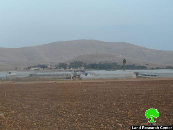
بالتزامن مع الموافقة المبدئية من قبل اللجنة التشريعية في حكومة الاحتلال على ضم الأغوار الفلسطينية، احتفل مستعمرو مستعمرة " جيتيت" المقامة على أراضي بلدة عقربا تحديداً على حوض " لفجم" من أراضي البلدة وذلك بوضع حجر الأساس لبناء حي استعماري جديد تابع للمستعمرة. يذكر أن الحي الاستعماري المقترح يقع ضمن الأراضي المصادرة كمناطق عسكرية من قبل الاحتلال في الجهة الشمالية الشرقية من المستعمرة. ففي عام 2001م، أقدم جيش الاحتلال على مصادرة مالا يقل عن 30 دونماً في محيط مستعمرة جيتيت وذلك بحجة إقامة منطقة عازلة بحسب ما ورد في الإخطار العسكري في ذلك الوقت. لكن وبعد أقل من ثلاثة أعوام من إعلان المصادرة، بدا مستعمرو جيتيت بالتوسع في الأراضي المصادرة عبر استغلالها من الناحية الزراعية، في حين منع المزارعين الفلسطينيين من فلاحة الأرض واستغلالها بأي شكل من الأشكال.

و الآن وبعد أكثر من 12 عاماً على مصادرة الأرض و منع أصحابها الشرعيين من الوصول إليها تحت أسباب عسكرية و أمنية بحسب وصف الاحتلال، يأتي قرار تحويل تلك الأرض المصادرة لغايات السكن والتوسع الاستعماري عبر إنشاء حي استيطاني جديد، وهو يشكل تناقضاً واضحاً ويكشف بالأصل أن قرار المصادرة يأتي بالأصل بهدف الاستيلاء على المزيد من الأرض وتهويد ما يمكن تهويده من أراضي الأغوار.


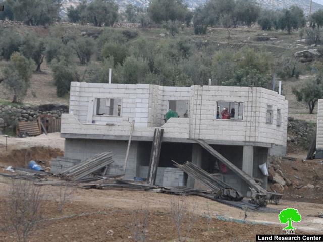
يذكر أن مستعمرة جيتيت بلغ عدد المستعمرين اليهود بها  119 مستعمراً، وبلغت مساحة مسطح البناء للمستوطنة 1060.6 دونماً، حيث أن هذه المستعمرة المصنفة ضمن المستعمرات الزراعية في منطقة الأغوار أخذت بالتوسع والتمدد بشكل كبير على حساب الأرض والإنسان الفلسطيني. وبالتزامن مع هذا التوسع الاستيطاني ينشط الاحتلال الإسرائيلي في هدم المنشآت السكنية والزراعية المصنوعة من الصفيح والخيش التابعة للتجمعات البدوية في الأغوار خاصة التجمع البدوي في خربة الطويل الذي شهد خلال الشهر الماضي موجة جديدة من عمليات الهدم التي طالت عدداً من البركسات الزراعية فيها. ( المصدر: وحدة النظم المعلوماتية التابعة لمركز أبحاث الأراضي)

اعداد: مركز أبحاث الاراضي – القدس  

Recommended For You

Israeli Breach of the Hebron Agreement through the Establishment of a New Settlement in Area (H1)

by arij
August 26, 2025
0
Israeli Breach of the Hebron Agreement through the Establishment of a New Settlement in Area (H1)

Introduction In a new provocative move, the Israeli occupation authorities have established a new settlement outpost in the heart of Hebron, specifically in Area (H1), which is under...

Read moreDetails

خرق إسرائيلي لاتفاقية الخليل بإنشاء مستوطنة جديدة في منطقة (H1)

by arij
August 26, 2025
0
خرق إسرائيلي لاتفاقية الخليل بإنشاء مستوطنة جديدة في منطقة (H1)

المقدمة في خطوة استفزازية جديدة، أقدمت سلطات الاحتلال الإسرائيلي على وضع بؤرة استيطانية جديدة في قلب مدينة الخليل، وتحديدا في منطقة (H1) الخاضعة للسيطرة الفلسطينية الكاملة وفق اتفاقية...

Read moreDetails

Escalation and forced displacement in Kisan

by arij
August 6, 2025
0

The village of Kisan, located southeast of the Bethlehem Governorate, has faced continuous attacks for many years by settlers and Israeli occupation forces as part of a systematic...

Read moreDetails

بؤرة استيطانية جديدة وتهجير قسري في كيسان

by arij
August 6, 2025
0

موقع الاستهداف، تقع قرية كيسان جنوب شرق محافظة بيت لحم، وتواجه منذ سنوات طويلة هجمات متواصلة من قبل المستوطنين وقوات الاحتلال الإسرائيلي ضمن سياسة ممنهجة تهدف إلى السيطرة...

Read moreDetails

Expansion of Gilo Settlement: A Strategic Plan to Isolate Bethlehem and Undermine Palestinian Rights

by arij
May 12, 2025
0
Expansion of Gilo Settlement: A Strategic Plan to Isolate Bethlehem and Undermine Palestinian Rights

The Israeli Civil Administration has announced a new settlement expansion plan—No. 101-1284223—which outlines the construction of 1,990 new settlement units on approximately 175.9 dunums of land extending towards...

Read moreDetails
Next Post
Stop-work orders on homes and demolition order on a structure

Stop-work orders on homes and demolition order on a structure

LATEST NEWS

Annexation of the Jordan Valley: Implications for the Two-State Solution and Regional Stability

Annexation of the Jordan Valley: Implications for the Two-State Solution and Regional Stability

by arij
September 29, 2025
0

........................................................

Isolation of Three Villages Northwest of Jerusalem: Silent Annexation Creeps toward the Capital

عزل ثلاث قرى فلسطينية شمال غرب مدينة القدس: الضم الاسرائيلي الصامت يزحف نحو محيط العاصمة

by arij
September 24, 2025
0

........................................................

Isolation of Three Villages Northwest of Jerusalem: Silent Annexation Creeps toward the Capital

Isolation of Three Villages Northwest of Jerusalem: Silent Annexation Creeps toward the Capital

by arij
September 24, 2025
0

........................................................

سياسات التهويد في القدس: من السيطرة المكانية إلى طمس الهوية عبر التسمية

سياسات التهويد في القدس: من السيطرة المكانية إلى طمس الهوية عبر التسمية

by arij
September 23, 2025
0

........................................................

flag_yellow_lowEU-PfP-Logo

This website and its content were initiated in 1993 by the Applied Research Institute – Jerusalem (ARIJ) and the Land Research Center (LRC) with the support from the European Union up until 2023. Since then, the Applied Research Institute – Jerusalem (ARIJ) has taken over the continued development and maintenance of the website. The views expressed remain solely those of ARIJ) and do not necessarily reflect those of the European Union.

© 2025 Copyright ARIJ . All Rights reserved. .

No Result
View All Result
  • Home
  • Settlements
    • New Israeli Settlements
    • Settlement Expansion
  • Israeli Violations
    • Agriculture
    • Confiscation
    • Demolition
    • Environment
    • Eviction of Palestinians
    • Settlers Attacks
  • Bypass Roads
  • Israeli Plans
  • Segregation
    • Checkpoints
    • Closure
    • Separation Plans
  • Military Orders
  • Reports
    • Daily Report
    • Monthly Report
    • Quarterly Report

© 2025 Copyright ARIJ . All Rights reserved. .