• About The Project
  • Palestine in Century
  • Selected Maps
  • Glossary
  • About ARIJ
  • About LRC
  • By Year
    • Case Studies By Year
    • Daily Report By Year
Friday, October 3, 2025
POICA
No Result
View All Result
  • Home
  • Settlements
    • New Israeli Settlements
    • Settlement Expansion
  • Israeli Violations
    • Agriculture
    • Confiscation
    • Demolition
    • Environment
    • Eviction of Palestinians
    • Settlers Attacks
  • Bypass Roads
  • Israeli Plans
  • Segregation
    • Checkpoints
    • Closure
    • Separation Plans
  • Military Orders
  • Reports
    • Daily Report
    • Monthly Report
    • Quarterly Report
No Result
View All Result
POICA
No Result
View All Result

The Israeli occupation notifies land in Qusra with takeover

December 22, 2013
in Military Orders
The Israeli occupation notifies land in Qusra with takeover


Violation: the occupation serves an confiscation order on lands

Date:22/12/2013

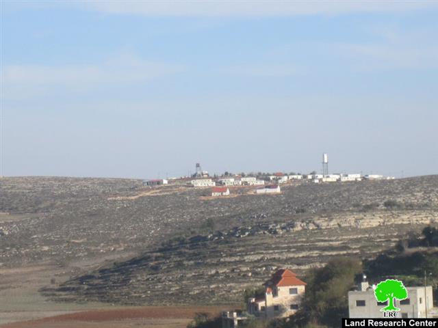
Location: Qusra village

Perpetrators: the army of the Israeli occupation

Victims: 30 agricultural families

Details:

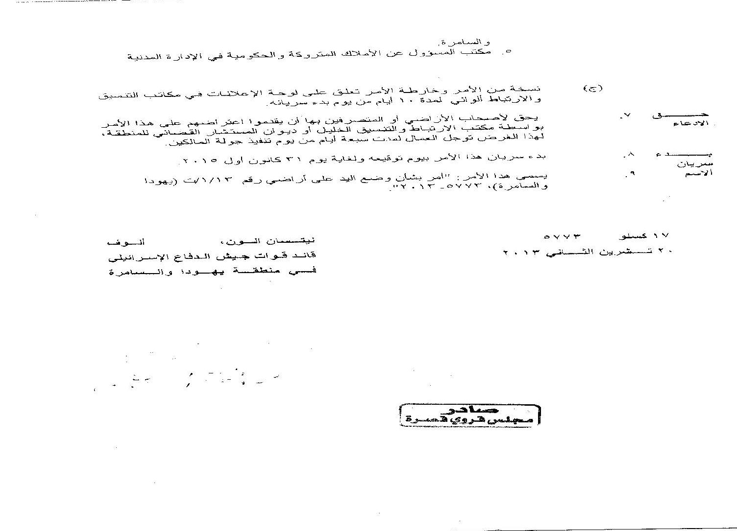
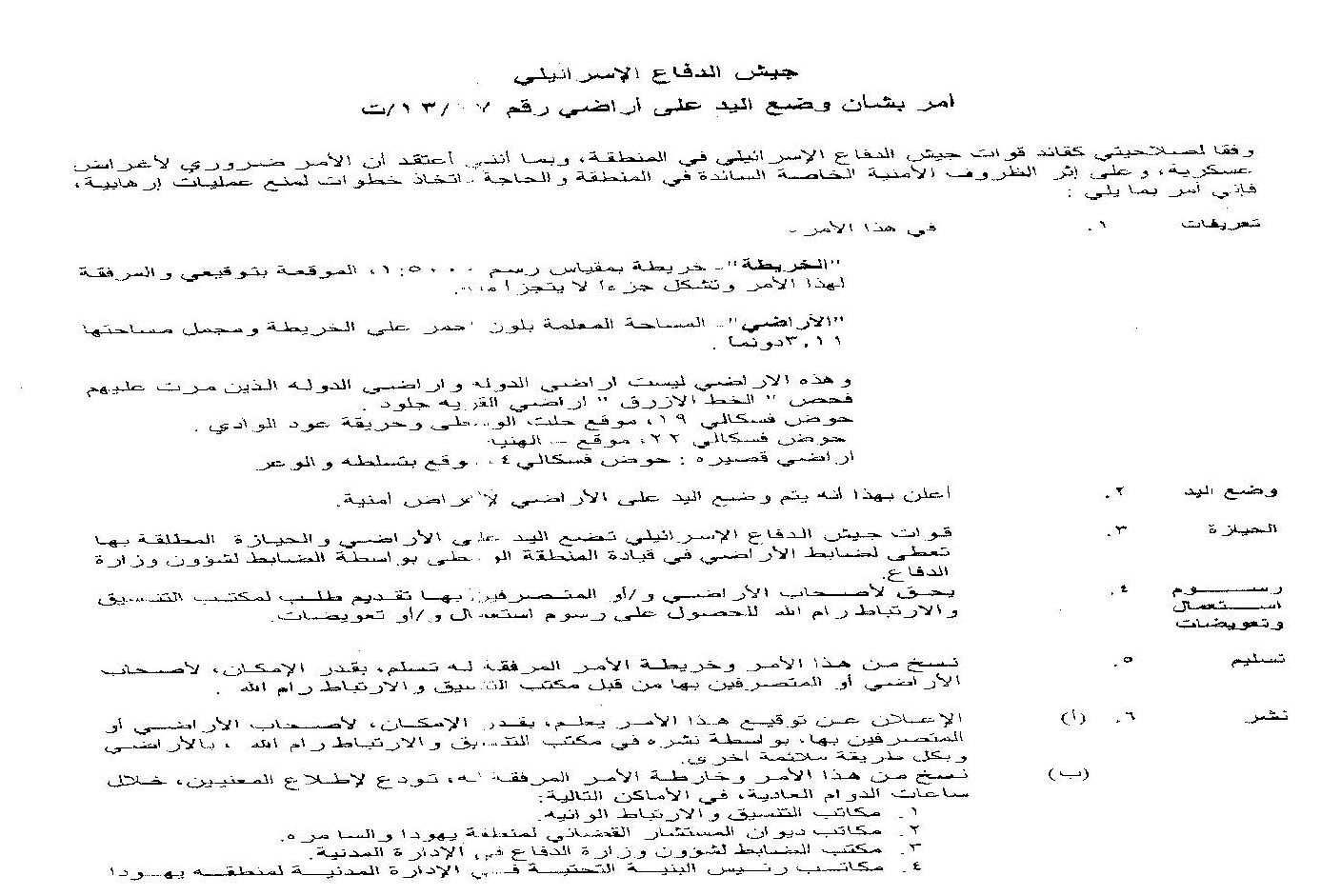
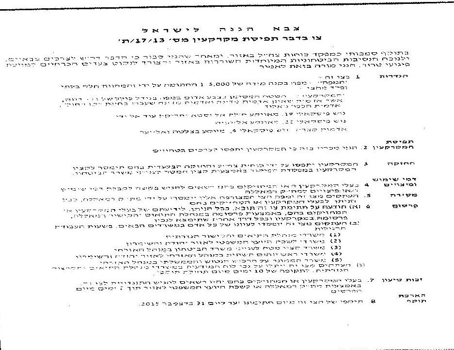
On December 22d 2013, the village council of Qusra was served an military order issued by the Israeli District Coordination Office DCO and signed by the commander of the army of the occupation in the West Bank. The order no.(T/31/7) attached with maps and photos mentioned putting hand on lands located between Yish Kodesh colony  and the area of al-We're, which is situated within the natural block no.19; piece no.22, east of Qusra. As usual, the occupation justified such an act under the pretext of  "Security reasons". 

According to the attached map, an area of 3.11 dunums will be confiscated and that the  apartheid fence will be set up in the colony periphery.


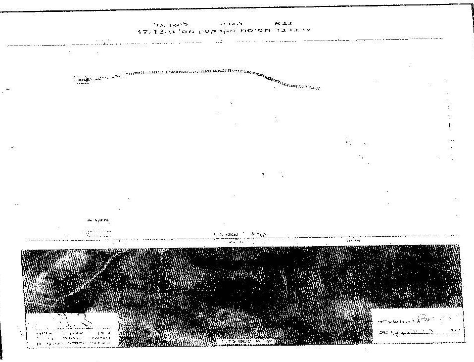
The attachment that came with the military order

It should be marked that the occupation banned Palestinian citizens from reaching out the 500dunums  periphery of Yish Kodesh  colony. This area will be classified as buffer zone. As a result, another 500 dunums will be confiscated. The lands declared inaccessible namely (al-Hinieh, Khallet el-Wusta, Hariqit Awad, al-Wadi, Baslta, and Shu'b al-We're) are about 1.5km within the colony borders.

It should be mentioned that the issuance of this order will have serious implications on not less than 30 families who own lands in the targeted location since the famers were denied access to it.  lands inaccessibility started in 2000 under the pretext of " security reasons" that were represented in protecting colonists who in this regard loot vast area to expand the colony.

It should also be marked that the order assigned December 26th 2013 for  a field tour for the owners of the lands. These farmers also have the right to object the order through  the DCO in Nablus area or in the office of the legal consultant of the area within a period of seven days from the tour time.

About Qusra:

It is located 18 km to the south east of Nablus city and is administered by Qusra village Council.Its total area is 9878 dunums that include 776 dunums of built up area. However, this area does not cover the expansion requirements of the village which forced a lot of the locals to build their houses in areas classified ‘C’ according to Oslo.

Qusra is inhabited by 4377 people according to the PBS statistics of 2007.

It must be pointed that in 1982, Qusra and the nearby Jurish villages faced a large scale land confiscation campaign in preparation for the establishment of Majdulim colony which now covers an area of 170.6 dunums inhabited by 152 colonists.

On the other hand, Qusra is suffering from the increase in demolition orders issued against structures in the village. More than 15 structures are facing real demolition threats. Migdalim colony have  been a starting point for several attacks on the Palestinians and their properties. In the summer of 2008, colonists plowed huge areas of Palestinian lands before capturing them, similar aggressions took place several times.

Also, numerous attacks on farmers and shepherds were reported throughout the years.On the other hand, the village is suffering from the increased number of demolition orders issued against structures in the village; so far, 15 structures and the village main road are threatened.


Prepared by
The Land Research Center
LRC

Recommended For You

سلطات الاحتلال الإسرائيلي تستغل ‘المنفعة العامة’ لنهب الموارد الفلسطينية

by arij
September 30, 2025
0
سلطات الاحتلال الإسرائيلي تستغل ‘المنفعة العامة’ لنهب الموارد الفلسطينية

في الاول من شهر ايلول من العام 2025، نشرت الإدارة المدنية الإسرائيلية، الذراع الأيمن لحكومة الاحتلال الإسرائيلي أمرا عسكريا جديدا تحت عنوان " أمر ءبشأن قانون الأراضي (الاستملاك...

Read moreDetails

The Occupation Targets the Village of Raba Southeast of Jenin with Military Orders and Seizes Vast Areas of Its Lands

by arij
September 13, 2025
0
الاحتلال يستهدف بأوامر عسكرية قرية رابا جنوب شرق جنين ويصادر مساحات واسعة من أراضيها

 The Israeli occupation Army have continued their policy of plundering Palestinian lands, as their bulldozers leveled wide areas of agricultural land in the village of Raba, southeast of...

Read moreDetails

الاحتلال يستهدف بأوامر عسكرية قرية رابا جنوب شرق جنين ويصادر مساحات واسعة من أراضيها

by arij
September 13, 2025
0
الاحتلال يستهدف بأوامر عسكرية قرية رابا جنوب شرق جنين ويصادر مساحات واسعة من أراضيها

  واصلت قوات الاحتلال الإسرائيلي سياسة نهب الأراضي الفلسطينية، حيث أقدمت آلياتها على تجريف أراض زراعية واسعة في قرية رابا جنوب شرق محافظة جنين، تمهيدا لشق شارع عسكري...

Read moreDetails

Nablus Governorate’s Archaeological Sites Face Israeli Expropriation Plans

by arij
September 11, 2025
0
” المواقع الأثرية في محافظة نابلس… ساحة مفتوحة أمام مخططات المصادرة الإسرائيلية “

On 10 August, 2025, the Israeli Civil Administration (ICA), issued a booklet of military orders signed by the head of the so-called ‘Israeli Civil Administration’ in the occupied...

Read moreDetails

” المواقع الأثرية في محافظة نابلس… ساحة مفتوحة أمام مخططات المصادرة الإسرائيلية “

by arij
August 26, 2025
0
” المواقع الأثرية في محافظة نابلس… ساحة مفتوحة أمام مخططات المصادرة الإسرائيلية “

في العاشر من شهر اب من العام 2025, أصدرت الإدارة المدنية الإسرائيلية كراسة أوامر عسكرية موقعة من قبل رئيس ما يسمى "بالإدارة المدنية الإسرائيلية" في الضفة الغربية المحتلة,...

Read moreDetails
Next Post

ARIJ Daily Report - Mon, 23/12/2013

LATEST NEWS

Annexation of the Jordan Valley: Implications for the Two-State Solution and Regional Stability

Annexation of the Jordan Valley: Implications for the Two-State Solution and Regional Stability

by arij
September 29, 2025
0

........................................................

Isolation of Three Villages Northwest of Jerusalem: Silent Annexation Creeps toward the Capital

عزل ثلاث قرى فلسطينية شمال غرب مدينة القدس: الضم الاسرائيلي الصامت يزحف نحو محيط العاصمة

by arij
September 24, 2025
0

........................................................

Isolation of Three Villages Northwest of Jerusalem: Silent Annexation Creeps toward the Capital

Isolation of Three Villages Northwest of Jerusalem: Silent Annexation Creeps toward the Capital

by arij
September 24, 2025
0

........................................................

سياسات التهويد في القدس: من السيطرة المكانية إلى طمس الهوية عبر التسمية

سياسات التهويد في القدس: من السيطرة المكانية إلى طمس الهوية عبر التسمية

by arij
September 23, 2025
0

........................................................

flag_yellow_lowEU-PfP-Logo

This website and its content were initiated in 1993 by the Applied Research Institute – Jerusalem (ARIJ) and the Land Research Center (LRC) with the support from the European Union up until 2023. Since then, the Applied Research Institute – Jerusalem (ARIJ) has taken over the continued development and maintenance of the website. The views expressed remain solely those of ARIJ) and do not necessarily reflect those of the European Union.

© 2025 Copyright ARIJ . All Rights reserved. .

No Result
View All Result
  • Home
  • Settlements
    • New Israeli Settlements
    • Settlement Expansion
  • Israeli Violations
    • Agriculture
    • Confiscation
    • Demolition
    • Environment
    • Eviction of Palestinians
    • Settlers Attacks
  • Bypass Roads
  • Israeli Plans
  • Segregation
    • Checkpoints
    • Closure
    • Separation Plans
  • Military Orders
  • Reports
    • Daily Report
    • Monthly Report
    • Quarterly Report

© 2025 Copyright ARIJ . All Rights reserved. .