• About The Project
  • Palestine in Century
  • Selected Maps
  • Glossary
  • About ARIJ
  • About LRC
  • By Year
    • Case Studies By Year
    • Daily Report By Year
Friday, May 22, 2026
POICA
No Result
View All Result
  • Home
  • Settlements
    • New Israeli Settlements
    • Settlement Expansion
  • Israeli Violations
    • Agriculture
    • Confiscation
    • Demolition
    • Environment
    • Eviction of Palestinians
    • Settlers Attacks
  • Bypass Roads
  • Israeli Plans
  • Segregation
    • Checkpoints
    • Closure
    • Separation Plans
  • Military Orders
  • Reports
    • Daily Report
    • Monthly Report
    • Quarterly Report
No Result
View All Result
POICA
No Result
View All Result

Attacks on Palestinian Farmers in Burin

March 2, 2013
in Israeli Violations
Attacks on Palestinian Farmers in Burin


Violation: attack on Palestinian farmers and confiscation of tools.

Date: March 1, 2013.

Perpetrators: colonists of Yizhar.

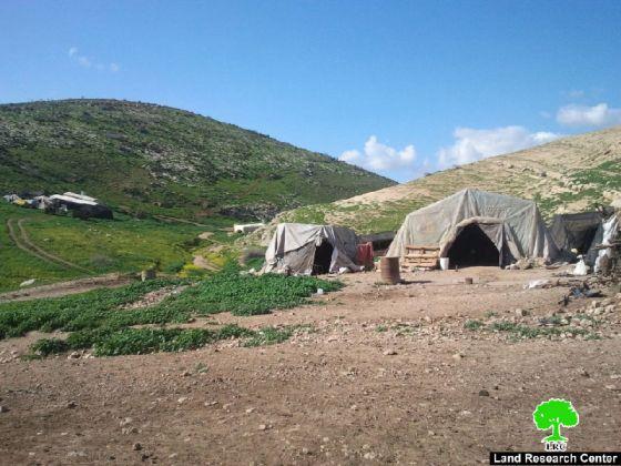
Location: north eastern side of Burin – Nablus.


Details:


At the beginning of the spring season of every year, Palestinian farmers become more active in terms of planting, plowing, and developing their lands; at the same time, Israeli colonists become active but in a brutal and inhuman ways.


On March 1, 2013, a group of colonists of Yizhar launched an attack on Palestinian farmers in the northern side of Burin. The colonists stole some equipment and some money before turning the fields upside down. The attack took place under the nose of the Israeli troops who were watching with joy. 


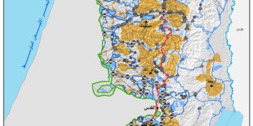
Picture 1: targeted location


Riza-Allah Qadus, one of the victims stated: ‘I own a plot located in Ein al Shara area, to the north of Burin, it is located 2 km away from Burin. The plot total area is 10 dunums, mostly planted with olives. It has been a complimentary source of living for my ten-member family. On March 1, I headed along Ismael Qadus and Jamal Qdus towards our plots in the area to trim the trees andplow the lands. Almost an hour later, more than 15 masked colonists attacked us but we fled leaving all the tools behind. They stole our tools, 2 axes, 3 saws and also stole my ID and 300 ILS. When they stole the tools we chased them but were stopped by the soldiers. We pleaded to the soldiers to stop them but they could not be any more careless, then they threatened to kill us if we did not leave immediately.‘


Burin Targeted by colonists:


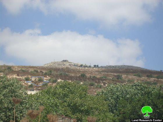
Ein al Shara and the northern side of Burin has been targeted by the Israeli colonists and soldiers on daily basis. Last year, 24 olive trees were cut down while in 2012, 98 were torched. The area has been declared as a ‘closed military zone’ inaccessible by the Palestinians but, at the same time, access-free for the colonists who has been spreading destruction in the area.


Prepared by
 The Land Research Center
LRC


Recommended For You

النكبة الفلسطينية في ذكراها الثامنة والسبعين: من التطهير العرقي إلى الإبادة وإعادة هندسة الجغرافيا الفلسطينية 

by arij
May 18, 2026
0
النكبة الفلسطينية في ذكراها الثامنة والسبعين: من التطهير العرقي إلى الإبادة وإعادة هندسة الجغرافيا الفلسطينية 

تحل الذكرى الثامنة والسبعون للنكبة الفلسطينية في ظل واحدة من أكثر المراحل دموية وخطورة في التاريخ الفلسطيني المعاصر، حيث تتداخل آثار النكبة الأصلية لعام 1948 مع واقع الحرب...

Read moreDetails

بين قصرة وترمسعيا: العنف الاستيطاني الاسرائيلي يضرب المجتمع الفلسطيني

by arij
May 6, 2026
0

في الثالث من شهر أيار من العام 2026، شهد مزارعون في عدة قرى في الضفة الغربية المحتلة على مشهد بات مألوفًا وقاسيا في آنٍ واحد: أشجار مثمرة مقطوعة...

Read moreDetails

INFOGRAPHIC: ISRAELI SETTLER VIOLENCE IN 2025

by arij
April 16, 2026
0

INFOGRAPHIC: ISRAELI SETTLER VIOLENCE IN 2025     Prepared by:   The Applied Research Institute – Jerusalem  

Read moreDetails

أدوات غير مباشرة للاستيطان الإسرائيلي في مناطق (أ) و(ب) لإعادة تشكيل الجغرافيا والسيطرة في الضفة الغربية   

by arij
April 16, 2026
0
العدالة المؤجلة ورأي بلا تنفيذ: من قرار المحكمة إلى واقع الضم

منذ توقيع اتفاقيات أوسلو في تسعينيات القرن الماضي، تم تقسيم الضفة الغربية إلى ثلاث مناطق إدارية وأمنية: (أ)، (ب)، و(ج)، بهدف تنظيم المرحلة الانتقالية نحو تسوية نهائية. وبموجب...

Read moreDetails

INFOGRAPHIC: Palestinian Trees – Victims of the Israeli occupation Army & Settler Groups in 2025

by arij
April 16, 2026
0

    INFOGRAPHIC: Palestinian Trees - Victims of the Israeli occupation Army & Settler Groups in 2025 Prepared by:   The Applied Research Institute – Jerusalem  

Read moreDetails
Next Post
Eviction Orders for 18 Palestinian Families

Eviction Orders for 18 Palestinian Families

LATEST NEWS

إقامة منطقة عسكرية عسكرية داخل أراضي (أ) في جنين

إقامة منطقة عسكرية عسكرية داخل أراضي (أ) في جنين

by arij
May 19, 2026
0

........................................................

النكبة الفلسطينية في ذكراها الثامنة والسبعين: من التطهير العرقي إلى الإبادة وإعادة هندسة الجغرافيا الفلسطينية 

النكبة الفلسطينية في ذكراها الثامنة والسبعين: من التطهير العرقي إلى الإبادة وإعادة هندسة الجغرافيا الفلسطينية 

by arij
May 18, 2026
0

........................................................

“بمساحة اجمالية 177 دونما من أرضي البيرة وبيتين”, طريق استيطاني لخدمة البؤر الاستيطانية في محافظة رام الله

“بمساحة اجمالية 177 دونما من أرضي البيرة وبيتين”, طريق استيطاني لخدمة البؤر الاستيطانية في محافظة رام الله

by arij
May 18, 2026
0

........................................................

“في خدمة مستوطنة ناحال حيلتس”, طريق استيطاني إسرائيلي جديد على أراضي بتير وبيت جالا في محافظة بيت لحم

“في خدمة مستوطنة ناحال حيلتس”, طريق استيطاني إسرائيلي جديد على أراضي بتير وبيت جالا في محافظة بيت لحم

by arij
May 18, 2026
0

........................................................

flag_yellow_lowEU-PfP-Logo

This website and its content were initiated in 1993 by the Applied Research Institute – Jerusalem (ARIJ) and the Land Research Center (LRC) with the support from the European Union up until 2023. Since then, the Applied Research Institute – Jerusalem (ARIJ) has taken over the continued development and maintenance of the website. The views expressed remain solely those of ARIJ) and do not necessarily reflect those of the European Union.

© 2026 Copyright | ARIJ | All Rights reserved.

No Result
View All Result
  • Home
  • Settlements
    • New Israeli Settlements
    • Settlement Expansion
  • Israeli Violations
    • Agriculture
    • Confiscation
    • Demolition
    • Environment
    • Eviction of Palestinians
    • Settlers Attacks
  • Bypass Roads
  • Israeli Plans
  • Segregation
    • Checkpoints
    • Closure
    • Separation Plans
  • Military Orders
  • Reports
    • Daily Report
    • Monthly Report
    • Quarterly Report

© 2026 Copyright | ARIJ | All Rights reserved.